MEASURING SYSTEM, AIRCRAFT MARKINGS, HOLIDAYS
1. UNITS OF MEASUREMENT
The units of measurement used in all air-ground operations are in accordance with the ICAO Annex 5.
Some of the magnitudes in common use are included in the following table:
MAGNITUDE | UNITS IN ICAO TABLE |
Altitudes, elevations and heights | Metres and feet |
Distance used in navigation | Nautical miles |
Relatively short distance (less than 4000 m) | Metres |
Horizontal speed, including wind speed | Knots or Mach |
Vertical speed | Feet per minute |
Wind direction for landing and taking off | Magnetic degrees |
Wind direction except for landing and taking off | True degrees |
Visibility, runway visual range | Kilometres and metres when less than 5 km |
Altimeter setting | Hectopascals (Milibars) |
Temperature | Celsius degrees |
Weight | Kilogrammes |
Time | Hours and minutes |
2. TEMPORAL REFERENCE SYSTEM
Universal Time Coordinated (UTC) and the Gregorian Calendar are used in the Air Navigation Services and in all documents published by the División de Información Aeronáutica unless otherwise specified.
Seasonal periods:
Summer: From the last Sunday of March until the Saturday before the last Sunday of October.
Local time: UTC + 2 hours.
Islas Canarias, local time: UTC + 1 hour.Winter: From the last Sunday of October until the Saturday before the last Sunday of March.
Local time: UTC + 1 hour.
Islas Canarias, local time: UTC.Weekend: From Friday at 1500 UTC until Monday at 0600 UTC.
3. HORIZONTAL REFERENCE SYSTEM
The aeronautical coordinates published in AIP-SPAIN refer to the WGS84 geodetic system, the epoch (measurement date) is provided in the digital dataset, pursuant to the provisions of Annex 15 of the ICAO.
The latest realization published by the NGA on the measurement date shall be used (at the date of update of this page it is G2139, equivalent to ITRF2014).
The area of application of the published geographical coordinates matches the area of responsibility of Spain’s air traffic services.
An asterisk (*) is used to indicate the coordinates that do not fulfil the quality requirements set in the Aeronautical Data Catalogue.
3.1 Local horizontal reference systems in Spain.
Royal Decree 1071/2007 of 27th July, adapted from the European Commission’s mandate of 1999 and which regulates the official geodetic reference system in Spain, establishes the ETRS89 (European Terrestrial Reference System 1989) system as the official geodetic reference system in Spain for geographic and cartographic referencing for both the Iberian peninsula and the Balearic Islands. The REGCAN95 system has been adopted for the Canary Islands. Both systems are associated with the GRS80 (Geodetic Reference System 1980) ellipsoid and have been implemented within the framework defined by the National Geodetic Network by Space Techniques (REGENTE), and its densifications.
Initially, considering the exactness required for the different data established in the Aeronautical Data Catalogue, ETRS89 and REGCAN95 were deemed equivalent to WGS84. However, the ongoing divergence between these systems have led to increasingly greater deviations from the exactness required for certain data, and therefore the ETRS89 and REGCAN95 systems cannot be considered valid for publishing coordinates in AIP-SPAIN.
When sending coordinates to the AIS, use WGS-84 and include as metadata the date of measurement (epoch).
4. VERTICAL REFERENCE SYSTEM
4.1 Description of the reference system
The altimetry reference system for Spain is defined by Real Decreto 1071/2007, Article 4.1, which assigns the mean sea level marks in Alicante as the altitude reference for the peninsula and the local mareographic references for each of the islands. The sources of the altimetry references are defined and published by the Spanish National Geographic Institute. On the other hand, Article 4.2 states that the system is implemented by the lines of the High Precision Levelling Network of Spain (REDNAP).
4.2 Geoid model
The Spanish National Geographic Institute has embraced the EGM2008 geoid model adapted to REDNAP, commonly referred to as EGM08-REDNAP, as the reference surface for orthometric heights. REDNAP implements the altitude system that most closely corresponds to the physical reality of the terrestrial surface in Spain, which means that this reference surface is much more precise than the EGM96 model.
The geoid altitudes with respect to the reference ellipsoid (geoid undulation) provided by EGM08-REDNAP, provide the information for converting the ellipsoid altitudes, obtained via GPS with respect to the reference ellipsoid, to the orthometric heights referred to in EGM08-REDNAP. These undulations of the geoid oscillate around 50 m in Spain.
4.3 Differences between the altitudes referenced in EGM08-REDNAP and those referenced in EGM96
The differences between the orthometric heights referenced in EGM08-REDNAP and the orthometric heights referenced in EGM96 (that is, the differences between the undulations of both geoids) depend on the geographic location of the point under consideration. The following table and map show the undulations and undulation differences of these models in Spain’s provincial capitals.
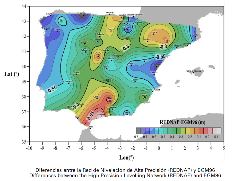
POINT | LON_ETRS89(º) | LA_ETRS89(º) | EGM08 REDNAP (m) | EGM08 (m) | EGM96 (m) | EGM08-GM96 (m) | EGM08 REDNAP-EGM08 (m) | EGM08 REDNAP-EGM96 (m) |
|---|---|---|---|---|---|---|---|---|
A Coruña | -8,39114853 | 43,3701264 | 54,421 | 55,0177 | 55,1208 | -0,103 | -0,597 | -0,7 |
Albacete | -1,85574745 | 38,9958805 | 52,036 | 52,5115 | 52,5489 | -0,037 | 0,475 | -0,513 |
Alicante | -0,4831832 | 38,3454871 | 49,892 | 50,469 | 50,4043 | 0,065 | -0,577 | -0,512 |
Almería | -2,46413188 | 36,8389236 | 49,722 | 50,2901 | 50,3183 | -0,028 | -0,568 | -0,596 |
Ávila | -4,69771277 | 40,6558696 | 54,37 | 54,95 | 54,454 | 0,496 | -0,58 | -0,084 |
Badajoz | -6,97099704 | 38,8787434 | 54,464 | 55,0548 | 55,0109 | 0,044 | -0,591 | -0,547 |
Barcelona | 2,17634927 | 41,3842466 | 49,128 | 49,6857 | 49,4461 | 0,24 | -0,558 | -0,318 |
Bilbao | -2,92390606 | 43,2572196 | 49,855 | 50,4934 | 50,0127 | 0,481 | -0,638 | -0,158 |
Burgos | -3,70419805 | 42,34113 | 53,477 | 54,0622 | 53,7017 | 0,36 | -0,585 | -0,225 |
Cáceres | -6,37121092 | 39,4731676 | 54,191 | 54,7216 | 54,5226 | 0,199 | -0,531 | -0,332 |
Cádiz | -6,28414575 | 36,5217115 | 44,89 | 45,424 | 45,0897 | 0,334 | -0,534 | -0,2 |
Castellón | -0,03688142 | 39,9864081 | 50,354 | 50,9131 | 51,1551 | -0,242 | -0,559 | -0,801 |
Ceuta | -5,30675127 | 35,8881021 | 41,992 | 42,5239 | 41,9638 | 0,56 | -0,532 | 0,028 |
Ciudad Real | -3,93131981 | 38,9865178 | 53,229 | 53,7677 | 54,0181 | -0,25 | -0,539 | -0,789 |
Córdoba | -4,78032455 | 37,8795423 | 50,399 | 50,8762 | 50,6005 | 0,276 | -0,477 | -0,201 |
Cuenca | -2,13152306 | 40,0765376 | 52,187 | 52,774 | 52,8136 | -0,04 | -0,587 | -0,627 |
Girona | 2,82411899 | 41,9818608 | 49,557 | 50,122 | 50,2695 | -0,148 | -0,565 | -0,712 |
Granada | -3,60001883 | 37,1764193 | 48,955 | 49,5324 | 49,4518 | 0,081 | -0,577 | -0,497 |
Guadalajara | -3,16210273 | 40,6343555 | 51,995 | 52,531 | 52,3056 | 0,225 | -0,536 | -0,311 |
Huelva | -6,95040588 | 37,2600411 | 51,87 | 52,4191 | 52,2058 | 0,213 | -0,549 | -0,336 |
Huesca | -0,40842276 | 42,1406274 | 50,58 | 51,1455 | 50,7443 | 0,401 | -0,566 | -0,164 |
Jaén | -3,7903594 | 37,7651913 | 49,632 | 50,1263 | 49,6156 | 0,511 | -0,494 | 0,016 |
Las Palmas | -15,41336841 | 28,0993785 | 43,661 | 43,733 | 41,9132 | 1,82 | -0,072 | 1,748 |
León | -5,56707631 | 42,599121 | 55,308 | 55,9328 | 55,8135 | 0,119 | -0,625 | -0,505 |
Lleida | 0,62061934 | 41,6152736 | 49,435 | 49,9837 | 49,5617 | 0,422 | -0,549 | -0,127 |
Logroño | -2,44565538 | 42,4664495 | 51,038 | 51,6187 | 51,7645 | -0,146 | -0,581 | -0,727 |
Lugo | -7,55817392 | 43,0091282 | 56,068 | 56,6518 | 56,5444 | 0,107 | -0,584 | -0,476 |
Madrid | -3,68760088 | 40,4084119 | 51,111 | 51,6641 | 51,6653 | -0,001 | -0,553 | -0,554 |
Málaga | -4,41997511 | 36,7203427 | 47,964 | 48,5103 | 47,8644 | 0,646 | -0,546 | 0,1 |
Melilla | -2,942281 | 35,294731 | 49,011 | 49,5688 | 49,238 | 0,331 | -0,558 | -0,227 |
Murcia | -1,1285408 | 37,9843636 | 50,194 | 50,6835 | 50,4676 | 0,216 | -0,49 | -0,274 |
Ourense | -7,86368375 | 42,3365492 | 55,738 | 56,3135 | 56,442 | -0,129 | -0,575 | -0,704 |
Oviedo | -5,84372206 | 43,3623217 | 53,925 | 54,4997 | 54,7317 | -0,232 | -0,575 | -0,807 |
Palencia | -4,53460106 | 42,0078373 | 53,51 | 54,145 | 53,7898 | 0,355 | -0,635 | -0,28 |
Palma | 2,65181698 | 39,571147 | 49,039 | 49,4409 | 49,742 | -0,301 | -0,402 | -0,703 |
Pamplona | -1,6451528 | 42,814102 | 49,985 | 50,6288 | 50,3554 | 0,273 | -0,644 | -0,37 |
Pontevedra | -8,64799018 | 42,4338144 | 55,291 | 55,866 | 55,9072 | -0,041 | -0,575 | -0,616 |
Salamanca | -5,66538084 | 40,9673682 | 55,335 | 55,8871 | 55,8178 | 0,069 | -0,552 | -0,483 |
San Sebastián | -1,98191785 | 43,3171716 | 48,634 | 49,2949 | 49,3848 | -0,09 | -0,661 | -0,751 |
Santa Cruz | -16,24720629 | 28,4628541 | 44,031 | 44,1201 | 46,363 | -2,243 | -0,089 | -2,332 |
Santander | -3,80474784 | 43,4629789 | 49,889 | 50,4719 | 50,1158 | 0,356 | -0,583 | -0,227 |
Segovia | -4,12524116 | 40,9498703 | 53,346 | 53,8959 | 53,6585 | 0,237 | -0,55 | -0,313 |
Sevilla | -5.99251368 | 37.3862051 | 49.846 | 50.4692 | 50.1048 | 0.364 | -0.623 | -0.259 |
Soria | -2.46624798 | 41.7632791 | 53.039 | 53.6243 | 53.2836 | 0.341 | -0.585 | -0.245 |
Tarragona | 1.2584219 | 41.1191029 | 49.108 | 49.707 | 49.6657 | 0.041 | -0.599 | -0.558 |
Teruel | -1.10927177 | 40.3441295 | 52.037 | 52.618 | 52.6173 | 0.001 | -0.581 | -0.58 |
Toledo | -4.02431421 | 39.8571519 | 52.396 | 52.9415 | 52.9067 | 0.035 | -0.545 | -0.511 |
Valencia | -0.37565717 | 39.4753444 | 50.075 | 50.609 | 50.714 | -0.105 | -0.534 | -0.639 |
Valladolid | -4.72334924 | 41.6523278 | 53.254 | 53.8839 | 53.6308 | 0.253 | -0.63 | -0.377 |
Vitoria | -2.67275685 | 42.8505879 | 50.86 | 51.4817 | 51.283 | 0.199 | -0.622 | -0.423 |
Zamora | -5.75494831 | 41.4991396 | 55.472 | 56.088 | 55.7578 | 0.33 | -0.616 | -0.286 |
Zaragoza | -0.87928652 | 41.6564566 | 49.852 | 50.4943 | 50.0495 | 0.445 | -0.642 | -0.198 |
5. AIRCRAFT NATIONALITY AND REGISTRATION MARKS
The nationality mark for aircraft registered in Spain is the letter group EC followed by a hyphen and a registration mark consisting of 3 letters or 2 letters and one digit, for example: EC-AUM, EC-JM7.
6. PUBLIC HOLIDAYS
Location of airports/heliports open to civil traffic and central services:
ANDALUCÍA: | Algeciras (HEL), Almería, Córdoba, Granada/Federico García Lorca Granada-Jaén, Jerez, Málaga/Costa del Sol and Sevilla. |
ARAGÓN: | Zaragoza, Huesca/Pirineos, Teruel. |
ASTURIAS: | Asturias. |
ILLES BALEARS: | Ibiza, Menorca, Palma de Mallorca and Mallorca/Son Bonet. |
CANARIAS: | El Hierro, Fuerteventura, Gran Canaria, La Gomera, La Palma, Lanzarote/César Manrique Lanzarote, Tenerife Norte/Ciudad de La Laguna and Tenerife Sur. |
CANTABRIA: | Santander/Seve Ballesteros-Santander. |
CASTILLA-LA MANCHA: | Albacete, Ciudad Real. |
CASTILLA Y LEÓN: | Burgos/Villafría, León, Salamanca/Matacán and Valladolid/Villanubla. |
CATALUÑA: | Andorra-La Seu d’Urgell, Barcelona/Josep Tarradellas Barcelona-El Prat, Girona, Lleida/Alguaire, Reus, Sabadell and Serveis Generals del Circuit de Catalunya (HEL). |
COMUNITAT VALENCIANA: | Alicante/Alicante-Elche Miguel Hernández, Castellón and Valencia. |
EXTREMADURA: | Badajoz/Talavera la Real. |
GALICIA: | A Coruña, Santiago/Rosalía de Castro and Vigo. |
COM. MADRID: | Madrid/Adolfo Suárez Madrid-Barajas, Madrid/Cuatro Vientos, Madrid/Getafe, Madrid/Torrejón and Headquarters. |
REGIÓN MURCIA: | Murcia/Aeropuerto de la Región de Murcia, Murcia/San Javier. |
C. FORAL NAVARRA: | Pamplona. |
PAÍS VASCO: | Bilbao, San Sebastián and Vitoria. |
LA RIOJA: | Logroño. |
CIUDAD DE CEUTA: | Ceuta (HEL). |
CIUDAD DE MELILLA: | Melilla. |
The Spanish public holidays for the year 2026 are (1):
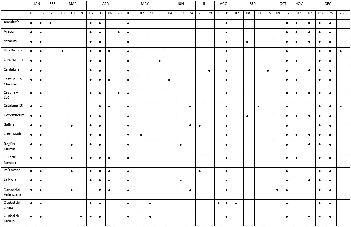
(1) To learn which services are affected consult with the aerodrome.
(2) In addition, for the year 2026, Canarias Autonomous Region has the following local holidays in each island:
El Hierro: 24 September.
Fuerteventura: 18 September.
Gran Canaria: 08 September.
La Gomera: 05 October.
La Palma: 05 August.
Lanzarote and La Graciosa:15 September.
Tenerife: 02 February.
(3) In Cataluña Autonomous Region for the year 2026:
Arán Territory: 17 June replaces to 26 December.
7. AERONAUTICAL CARTOGRAPHY USED
The basic topography used for the production of charts is provided by the Centro Nacional de Información Geográfica on digital format, BCN 200 series.
IAC and VAC charts only include obstacles exceeding 100 m in height. In addition, IAC charts also include controlling obstacles for every segment of the procedure, as far as possible. Every obstacle is depicted with its corresponding symbol and total elevation.