LESU AD 2 AERODROME DATA
AERODROME LOCATION INDICATOR – NAME
LESU – ANDORRA – LA SEU D’URGELL
AERODROME GEOGRAPHICAL AND ADMINISTRATIVE DATA
ARP |
422046N 0012453E. See AD 2-LESU ADC. |
|
Distance and direction from the city |
3.8 km SW. |
|
Elevation |
802 m / 2630 ft. |
|
Geoid undulation |
53.03 + 0.05 m. (1) |
|
Reference temperature |
30º C. |
|
Low average temperature |
3º C. |
|
Magnetic variation |
1º E (2020). |
|
Annual change |
7.8’E. |
|
AD administration |
Aeroports de Catalunya. |
|
Address |
Aeródromo Andorra-La Seu d'Urgell – 25711, Montferrer (Lleida). |
|
TEL |
+34-973 355 324 |
|
FAX |
+34-973 360 934 |
|
AFTN |
LESU |
|
Approved traffic |
VFR, VFRN (2) and IFR. |
|
Remarks |
(1) For all AD points. (2) See item 20. |
OPERATIONAL HOURS
Airport |
HR AD (Restricted use): V: MON–SUN 0630–CCV; I: MON–SUN 0730 -CVV.
|
|
Custom and Immigration |
No. |
|
Health and Sanitation |
No. |
|
AIS/ARO |
Yes (2) |
|
MET briefing |
V: MON–SUN 0800–1600. I: MON–SUN 0800–1600. Other hours under PPR. |
|
ATS |
PPR 24 HR. (3) |
|
Fuelling |
30 MIN after AD opening time until 30 MIN before AD closing time. (4) |
|
Handling |
Yes, PPR 24 HR to HandlingLESU@lesu.cat |
|
Security |
Yes, PPR 24 HR to operacions@lesu.cat |
|
De-icing |
No. |
|
Remarks |
(1) See item 20.
(4) Fuelling available during public and restricted use by gravity. By pressure PPR 24 HR. |
HANDLING SERVICES AND FACILITIES
Cargo facilities |
No. |
|
Fuel types |
AVGAS 100LL, JET A-1. |
|
Oil types |
No. |
|
Refuelling capacity |
AVGAS 100LL: 5000 L, 6.6 L/s. |
|
De-Icing facilities |
No. |
|
Hangar space |
No. |
|
Repair facilities |
No. |
|
Remarks |
None. Ramp agents:
Ramp agents may attend both commercial and general aviation and business. General and Business Aviation Managers (FBO). For passengers and crew who opt to access through the General and Business Aviation terminal, the General and Business Aviation Managers (FBO) authorised by the airport are:
|
PASSENGER FACILITIES
Hotels |
No. |
|
Restaurant |
Yes. See schedules on www.aeroportandorralaseu.cat |
|
Transportation |
No. Taxi O/R to the AD manager. |
|
Medical facilities |
First-aid kit. |
|
Bank/Post Office |
No. |
|
Tourist information |
No. |
|
Remarks |
All services above are available at La Seu d’Urgell, 3.8 km SW. |
RESCUE AND FIRE FIGHTING SERVICES
Fire category |
HR AD restricted use: own means. |
|
Rescue equipment |
According to the fire category published. |
|
Removal of disabled aircraft: |
Service provided by external companies with a maximum response time of 5 HR. Cranes and support equipment with a capacity up to 23 TM. |
|
Remarks |
(1) See item 20. Operational hours: From 15 minutes before the activation of the public use infrastructure until 15 minutes after it is deactivated. Service hours: From one hour before the operational hours until 15 minutes after the deactivation of public use hours. (2) Operational objective of response time up to RWY 03/21 end, less than 3 MIN. |
RUNWAY SURFACE CONDITION ASSESSMENT AND REPORTING AND SNOW PLAN
Types of clearing equipment |
Not applicable. |
|
Clearance priorities |
Not applicable. |
|
Use of material for movement area surface treatment |
Not applicable. |
|
Specially prepared winter runways |
Not applicable. |
|
Remarks |
Runway surface condition assessment and reporting in accordance with the Global Reporting Format (GRF) methodology described in AD 1.2.2. Aerodrome in service during all seasons of the year. |
MOVEMENT AREA DETAILS
Apron |
Surface: Asphalt. Strength: PCN 74/F/D/W/T. |
|
Taxiways |
Width: 15 m. Surface: Asphalt. Strength:PCN 18/F/A/W/T. |
|
Check locations |
Altimeter: Runway-holding position, head of RWY 03: 802 m / 2628 ft. VOR: No. INS: See AD 2-LESU PDC. |
|
Remarks |
None. |
TAXIING GUIDANCE SYSTEM AND MARKINGS
Taxiing guidance system |
Runway-holding positions, indication signs to stands, NO ENTRY signs. |
|
RWY markings |
Threshold, designators, centre line, side stripe |
|
TWY markings |
Side stripe and centre line, spotlight markers on TWY edge. |
|
Remarks |
None. |
AERODROME OBSTACLES
Obstacles which penetrate Approach, Take-Off Climb, Conical, Inner Horizontal, Transitional, Inner Transitional and Balked Landing Surfaces established in ICAO Annex 14; and the areas 2A and 3 established in ICAO Annex 15. Those penetrating these surfaces are identified in the CSV file as "Relevante_Relevant = Si/Yes": |
See Item 10 and Digital Data section. |
|
Remarks |
See AD 2-LESU AOC. |
METEOROLOGICAL SERVICE PROVIDED
MET office |
Andorra-La Seu d'Urgell EMAe. |
|
HR |
See item 3. |
|
METAR |
Half-hourly. |
|
TAF |
24 HR. |
|
TREND |
No. |
|
Briefing |
In person and by telephone. |
|
Flight documentation/Language |
Charts and plain language/Spanish. |
|
Charts |
Significant forecasted maps, and wind and temperature in altitude. |
|
Supplementary equipmet |
No. |
|
ATS unit served |
AFIS. |
|
Additional information |
Valencia OMAe (LEVA): H24;
Andorra-La Seu d'Urgell EMAe: HR: see item 3;
|
|
Remarks |
Aerodrome warnings available. |
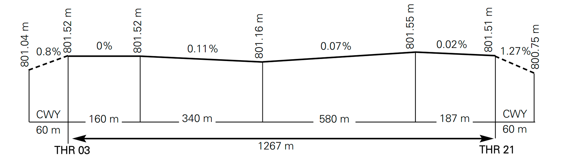
RUNWAY PHYSICAL CHARACTERISTICS
| RWY |
Direction |
DIM (m) |
THR PSN |
THR ELEV TDZ ELEV |
SWY (m) |
CWY (m) |
Strip (m) |
OFZ |
RESA (m) |
RWY/SWY SFC PCN |
|---|---|---|---|---|---|---|---|---|---|---|
03 |
031.01° GEO 030° MAG |
1267 x 28 |
422010.17N 0012424.04E |
THR: 802 m / 2628 ft TDZ: No |
No |
60 x 150 |
1387 x 80 |
No |
No |
RWY: ASPH PCN 17/F/A/W/T SWY: No |
21 |
211.01° GEO 210° MAG |
1267 x 28 |
422045.37N 0012452.56E |
THR: 802 m / 2628 ft TDZ: No |
No |
60 x 150 |
1387 x 80 |
No |
No |
RWY: ASPH PCN 17/F/A/W/T SWY: No |
Remarks: None. |
||||||||||
Profile:
DECLARED DISTANCES
| RWY |
TORA (m) |
TODA (m) |
ASDA (m) |
LDA (m) |
|---|---|---|---|---|
03 |
1267 |
1327 |
1267 |
1267 |
21 |
1267 |
1327 |
1267 |
1267 |
Remarks: None. |
||||
APPROACH AND RUNWAY LIGHTING
Runway |
03 |
|
Approach |
Threshold identification lights. |
|
PAPI (MEHT) (1) |
3.05º (7.64 m / 25 ft) (2) |
|
Threshold |
Green |
|
Touchdown zone |
No. |
|
Runway centre line |
No. |
|
Runway edge |
1267 m white. (4) |
|
Runway end |
Red |
|
Stopway |
No. |
|
Remarks |
(1) Possible unexpected information on PAPI RWY 03 during restricted use hours, 10 minutes before the activation of public use hours.
(4) Adjustable intensity and omnidirectional lights. |
Runway |
21 |
|
Approach |
Threshold identification lights. |
|
PAPI (MEHT) |
2.99° (9.6 m / 32 ft). (1) (2) |
|
Threshold |
Green |
|
Touchdown zone |
No. |
|
Runway centre line |
No. |
|
Runway edge |
1267 m white. (3) |
|
Runway end |
Red |
|
Stopway |
No. |
|
Remarks |
(1) To give notification of occurrences or request a higher intensity, contact the AFIS Unit at Andorra-La Seu d’Urgell AD: 122.205 C.
(3) Adjustable intensity and omnidirectional lights. |
OTHER LIGHTING, SECONDARY POWER SUPPLY
ABN/IBN |
Yes. |
|
WDI |
1 near THR 03 LGTD, 1 near THR 21, 1 near middle of RWY, no LGTD. |
|
TWY lighting |
Centre line: TWY B, C, D and GATE B. |
|
Apron lighting |
Floodlighting poles. |
|
Secondary power supply |
Engine generators that provide a maximum switch-over time (light) of 15 SEC for THR identification lights, THR, edge and RWY end, PAPI, TWY centre line, APN, TWR, SEI and power building. |
|
Remarks |
(1) 11 lattice towers on Montículo de Ensiula, Type C and Type B obstacle lights on the megatower closest to the runway and WDI. |
HELICOPTER LANDING AREA
Position: Use of runway for landing.
|
FATO: RWY 03/21. See item 12. |
|
Elevation
|
FATO: RWY 03/21. THR 03 and THR 21 elevation, see item 12. |
|
Dimensions, surface, maximum weight, marking
|
FATO: RWY 03/21. See items 9 and 12. |
|
Direction |
FATO: RWY 03/21. See item 12. |
|
Declared distances |
FATO: RWY 03/21. See item 13. |
|
Lighting
|
FATO: RWY 03/21. See item 14. |
|
Remarks |
None |
ATS AIRSPACE
| Designation and lateral limits |
Vertical limits |
Airspace class |
Unit Language |
Transition altitude |
|---|---|---|---|---|
FIZ REDUCIDA ANDORRA-LA SEU D’URGELL (RMZ) (FPMZ) (1) |
SFC-5000 ft AMSL |
G |
LA SEU AFIS (2) ES/EN |
2438 m / 8000 ft |
FIZ AMPLIADA ANDORRA-LA SEU D’URGELL (RMZ) |
SFC-7500 ft AMSL |
G |
LA SEU AFIS (2) ES/EN |
|
Remarks |
AD located to the NW of TMA BARCELONA and on the VFR traffic sector with vertical limits: 1000 ft AGL/AMSL-MAX ALT VFR SECTOR (FL080) (see ENR 2.1). The FIZ will only be active during ATS hours. (1) Flight plan submission mandatory zone within AFIS HR. (2) Call sign: La Seu Información. HR ATS: see item 3. |
|||
ATS COMMUNICATION FACILITIES
| Service |
Call sign |
FREQ |
HR |
Remarks |
|---|---|---|---|---|
AFIS |
La Seu Información |
122.205 C |
H24 (1) |
(1) Outside ATS operation hours, this frequency shall be used for A/A communications. |
131.605 C |
HR ATS (2) |
BACK-UP. (2) Outside ATS operation hours, this frequency shall be used for G/A communications. |
||
121.500 MHz |
HR ATS |
EMERG |
RADIO NAVIGATION & LANDING FACILITIES
| Facility (VAR) |
ID |
FREQ |
HR |
Coordinates |
ELEV DME |
Remarks |
|---|---|---|---|---|---|---|
No. |
LOCAL REGULATIONS
Maximum aircraft allowed on the infrastructure, ATR42. Maximum helicopter allowed, A139.
Aircraft with a wingspan higher than 17 m may only taxi via the taxiway on apron N, accessing PRKG 21-23 by GATE B. TWY W and G are limited to C550 and PC24 maximum aircraft respectively.
Helicopters may accomplish both air and ground-taxiing on the aerodrome taxiways. Helicopters with a rotor blade diameter larger than 13 m may only accomplish air-taxiing via apron taxiways E and N. On N air-taxiing may only take place to access PRKG 21 and 22. Helicopters with a rotor blade diameter larger than 12.46 m cannot accomplish air-taxiing via TWY W and G. TWY I is exclusive for helicopter use and is limited to H146.
Helicopters accessing PRKG 21 and 22 must taxi by TWY N, accessing through GATE B.
Helicopter air-taxiing to access PRKG 31-32, 40-42 and 44 must be accomplished via TWY M, being access prohibited from TWY N.
To access the fuelling area, hangar D1 and PRKG 44, visual reference points are available on TWY N and W where aircraft accessing this area will have to stop. See more details on subparagraphs Public Use Operations or Restricted Use Operations, as applicable.
With aircraft PC24 leaving the fuelling area, no taxiing of helicopters from/to PRKG 44 can take place. However, no impact exists to exit the fuelling area for aircraft parked on the C172 area. With aircraft in the refueling area, aircraft bound to or from hangar D1 cannot circulate via TWY G.
Aircraft on ground-taxiing accessing this area may do so via any of the two points. However, helicopters on air-taxiing may only access from the point located on W.
Gravity fuelling in the fuelling area for maximum aircraft PC24. Aircraft up to size C172 will park on the marked position parallel to the fuel tanks. Aircraft over that size, up to PC24, will park on the marked position perpendicular to the fuel tanks. Helicopters (skids) with a rotor blade up to 12.46 m will park on the PC24 spot.
Helicopters with a rotor blade diameter higher than 13 m, which need to access the hangar zone and are lacking wheels for ground taxi, shall be towed through apron taxiway S up to the corresponding hangar.
OPERATIONAL MINIMA
At the AD, VFR flight operations will be conducted under VMC.
At the AD, RNAV1 instrument departure operations will be conducted with visibility 1300 m from the threshold.
At the AD, RNP approach instrument operations will be conducted with visibility 7.8 km and cloud ceiling 2200 ft.
Operating with snow, slush, frost or ice on the runway is prohibited.
Take extreme care with winds of more than 20 kt.
ULM with crosswinds greater than 20 kt operations are prohibited
Specific approval of the operator is required for flying instrument manoeuvres.
ACCEPTANCE OF AIRLINES
Air carriers seeking to operate commercially in the infrastructure must request the airport manager’s approval according to the internal procedure by sending an email to: operacions@lesu.cat
RESTRICTED USE OPERATION
Radio equipment is required to operate on the AD.
The provisions specified in SERA.4001, item b), point 3, shall apply with regard to the submission of flight plans.
Aircraft using the AD are obliged to have adequate equipment in order to monitor frequency 122.205 C for self-control. On that same frequency they shall transmit their intentions and their evolution through the different phases of the flight, in order to provide other aerodrome traffic with information that shall aid in keeping own separation if required.
The Operations Centre of Andorra-La Seu d’Urgell AD may offer orientation on apron occupancy, provide refuelling services and further information of interest. Contact on frequency 131.605 C after runway is vacated.
No aeronautical station shall provide any type of aerodrome information on frequency 122.205 C.
On TWY N the visual reference point is the identification horizontal marking to access PRKG I, and on TWY W the EPL (equipment parking area marking) perpendicular to TWY W which limits PRKG K. In case of air-taxiing, the DGPEIS group will access from TWY W. Contact with 122.205 C must take place to inform about intentions.
PUBLIC USE OPERATION VFRN
AFIS provision hours shall be published by NOTAM. Consult NOTAM and SNOWTAM in force before operating on the infrastructure. NOTAM will be published with minimum advance notice of 18 HR. In any case contact with TWR will be established before entry on FIZ.
The night-time use of the LESU airport is only for commercial operation during public use and is incompatible with the night-time use of the H24 heliport. Both infrastructures cannot be operational at the same time. The coordination between both infrastructures shall be carried out via the email address:operacions@lesu.cat At night-time, only the following may be used: GATE B, taxiways C and B to enter and exit the runway, and it shall be compulsory to use a radio altimeter and the commercial operator has previous experience operating during daytime use.
The following radio altimeter notification points are established in the VFRN: 421957.62N and 0012606.38E; 422106.78N and 0012720.15E.
To operate in the FIZ, when activated, it is compulsory to file a flight plan and to carry radio equipment on board.
The movement of persons or vehicles, including aircraft being towed within the movement area, is subject to advance clearance from the AFIS personnel on duty at the AFIS unit.
Pilots wishing to accomplish taxi service or passenger commercial transport flights must request the activation of public use aerodrome at least 24 HR in advance of the estimated hour of operation, by means of an electronic mail to operacions@lesu.cat and telephonic acknowledgement to:
- TEL: +34-973 355 324.
The request to carry out commercial operations must be submitted within the airport's published operating hours so that operations may receive and accept it. The request must contain the following information:
- Flight number.
- Flight class.
- Ground handling service contracted.
- Aircraft type.
- Scheduled dates and times.
- Level of RFFS protection required.
Operations will make the necessary communications to confirm the provision of necessary services for the operation in public use and issue the corresponding NOTAM. Once this has been done, they will notify the applicant of the authorisation by the same means by which the request was received. The operation will not be considered authorised if not expressly confirmed by airport operations. The hiring of ground handling services authorised by the airport is mandatory for commercial operations.
The movement of persons or vehicles, including aircraft being towed within the movement area, is subject to advance clearance from the AFIS personnel on duty at the AFIS unit.
ULM operating during public use must satisfy the following requirements:
- Operate with radio which guarantees bidirectional communications.
- Submit FPL.
- Know how to use the radio equipment.
- Know and understand aeronautical phraseology.
During public use operation PRKG 11 to 17, 21 to 23 are reserved for the parking of passenger commercial transport and air taxi aircraft.
On TWY N the visual reference point is the identification horizontal marking to access PRKG I, and on TWY W the EPL (equipment parking area marking) perpendicular to TWY W which limits PRKG K. In case of air-taxiing, the DGPEIS group will access from TWY W. Contact with AFIS must take place on these points.
Access to PRKG H, I and K by general aviation on the apron, shall only take place through TWY M. Traffic of aircraft via TWY M is not allowed during autonomous exit from PRKG 21 to 23. While helicopters are turning in PRKG 21 and 22, aircraft may not circulate via TWY M.
OPERATIONAL SAFETY REPORTS
On the specific instance of safety reports related with the aeronautical information service provider AFIS, these may be sent to the e-mail address: safety@skyway-ans.com
RNP RWY 03 APPROACH
For instrument operations, contact the airport manager at: operacions@lesu.cat
Instrument approach is only permitted for commercial operations and requires airport validation.
The validation is obtained by accrediting training in at least the following items:.
- The training must consist of an overall theoretical instruction of the procedure and at least one real execution (or in a simulator certified for this) under VMC throughout the approach from the IAF to landing.
- Explanation of stabilised approach criteria.
- Familiarisation of pilots with the manoeuvre.
- Explanation of the difference between RNAV (GNSS) procedures with minima lines LNAV, LNAV/VNAV, LPV.
- Explanation of the final approach segment, in particular in relation to the position of the MAPt and the flight height on passing over this point.
- The position of the controlling obstacles in each segment.
- It must be remembered to add 50 ft to the minima of the approach chart to descend using the CDFA technique.
- Explanation of the operational concept, transfer from Barcelona approach to AFIS-SEU.
- RAIM function pre-flight verification of the availability of this function.
- Verification of the RAIM function 30 NM from the ARP, and of the GNSS navigation capacity at the IAF and before reaching the FAF.
- Situation in the event of loss of GNSS navigation capacity.
- Rejected landing manoeuvre RWY 03. Indicate the gradients required as determined by the starting point of the manoeuvre.
- Circling visual flight manoeuvre for landing on RWY 21.
- If the installation of any new system is required in the aircraft, the corresponding instruction for the same must be included.
- Recommendation not to use the PAPI system in the last mile before the threshold.
- Wind limitations for operation at the airport.
In the approach briefing, the singular points of this RNP APCH instrument procedure shall be recalled.
FIZ REDUCIDA OPERATION
Only for VFR flights.
Segregation of commercial VFR traffic with respect to ULM.
ULM wishing to operate during the public use hours published, must send a request 1 hour ahead of the estimated time of flight by means of an e-mail to the address: operacions@lesu.cat and by telephonic confirmation TEL: +34-973 355 324 in order to determine the possibility of accomplishing the flight and, if so, fix flight times.
FIZ AMPLIADA OPERATION
Only one simultaneous IFR operation shall be permitted within the FIZ. There cannot be two IFR flights simultaneously within the FIZ.
Segregation of commercial IFR traffic with respect to VFR traffic.
VFR traffic wishing to operate during the public use hours published, must send a request 1:30 hours ahead of the estimated time of flight by means of an e-mail to the address: operacions@lesu.cat and by telephonic confirmation TEL: +34-973 355 324 in order to determine the possibility of accomplishing the flight and, if so, fix flight times.
NOISE ABATEMENT PROCEDURES
No.
FLIGHT PROCEDURES
Helicopters shall use the same reporting points on the aerodrome traffic circuit as the rest of aircraft, and shall land on and take-off from the runway.
LOW VISIBILITY PROCEDURES (LVP)
Low visibility procedures are not available at Andorra-La Seu d’Urgell airport.
AD TRAFFIC CIRCUIT
ADDITIONAL INFORMATION
Windshear on final, especially RWY 21.
Mound on the vicinity of RWY 21.
Take-off or landing of any traffic not considered ULM, helicopters or aircraft will not be cleared at LESU. The activity of paragliders, paramotors and the like is prohibited with FIZ AMPLIADA or FIZ REDUCIDA activated.
Paraglider activity on approach to RWY 03 (in the vicinity of the VFR reporting point “S” of the FIZ REDUCIDA) and take-off from RWY 21 and model aircraft activity at the coordinates 422000N 0012735E.
Where necessary, IFR or VFR traffic may contact TWR on: TEL: +34-973 354 810
A single type of FIZ will be activated each day.
In case of emergency landing by gliders, their departure via TWY A is prohibited.
To conduct special activities in the vicinity of the airport, please contact: operacions@lesu.cat
Andorra-La Seu D'Urgell airport has the appropriate means and local procedures for the treatment of the ATR72 as a higher code letter aircraft.
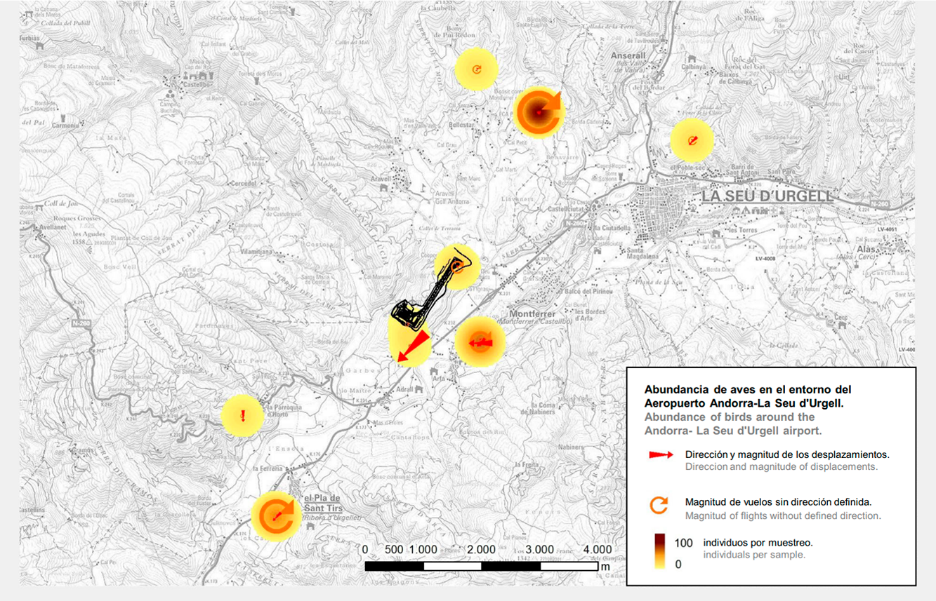
CONCENTRATION AND FLOWS OF BIRDS
Frequent presence of griffon vultures and red kites in the surrounding areas of the airport, especially concentrated on RWY 03 departures and RWY 21 arrivals
CHARTS RELATED TO THE AERODROME
The list of charts related to the aerodrome can be found on the link below:
VISUAL SEGMENT SURFACE (VSS) PENETRATION
Not applicable.