LETA AD 3 HELIPORT DATA
HELIPORT LOCATION INDICATOR and-NAME
LETA - SERVEIS GENERALS DEL CIRCUIT DE CATALUNYA
HELIPORT GEOGRAPHICAL AND ADMINISTRATIVE DATA
Heliport reference point |
413426N 0021525E. See AD 3-LETA HELC. |
|
Distance and direction from the city |
2.5 km N. |
|
Elevation |
150 m / 491 ft. |
|
Geoid undulation |
49 m ± 0.05 m (1). |
|
Reference temperature |
27°C. |
|
Magnetic variation |
1°E (2020). Annual change: 7.5'E. |
|
HLP administration |
BG Helicopters S.L.U. |
|
Address |
Mas “La Moreneta” Apdo. Correos 27, 08160 Montmeló (Barcelona) |
|
Contact |
TEL: +34-935 167 044 |
|
AFTN |
LETA |
|
info@bghelicopters.com |
||
|
Approved traffic |
VFR. |
Remarks |
(1) for all HEL points. |
OPERATIONAL HOURS
Heliport |
|
|
Customs and Immigration |
No. |
|
Health and Sanitation |
No. |
|
AIS/ARO |
HR HEL. (2) (3) |
|
MET briefing |
HR HEL. |
|
ATS |
No. |
|
Fueling |
No. |
|
Handling |
PPR 48 HR. |
|
Security |
During public use of heliport. |
|
De-icing |
No. |
|
Remarks |
|
HANDLING SERVICES AND FACILITIES
Cargo facilities |
No. |
|
Fuel types |
No. |
|
Oil types |
No. |
|
Refuelling capacity |
No. |
|
De-icing facilities |
No. |
|
Hangar space |
HR HEL PPR 48 HR. |
|
Repair facilities |
No. |
|
|
Remarks |
None. |
PASSENGER FACILITIES
Hotels |
In the city. |
|
Restaurant |
No. |
|
Transportation |
No. |
|
Medical facilities |
No. |
|
Bank/Post Office |
No. |
|
Tourist information |
No. |
|
Remarks |
None. |
RESCUE AND FIREFIGHTINGSERVICES
Fire category |
HR HEL restricted use: No. HR HEL public use: H2. (1) |
|
Rescue equipment |
In accordance with the fire category published. |
|
Removal of disabled aircraft |
Service provided by companies external to the HEL. Maximum response time: 1 hour. Minimum equipment: Truck with tilting container trailer for carrying aircraft up to 2 TM, semi-trailer, tow truck and set of steel cables and slings. |
|
Remarks |
(1) See item 19. Operational hours: For the departure of aircraft, from the moment before the start-up of engines until 15 minutes after take-off. For the arrival of aircraft, from 10 minutes before the estimated time of landing or from the moment of clearance for landing, until the engines are stopped. Service hours: From one and a half hours before the operational hours until 45 minutes after the deactivation of public use hours. |
SEASONAL AVAILABILITY -/OBSTACLE CLEARING
Equipment |
No. |
|
Priority |
No. |
|
Remarks |
None. |
Aprons, taxiways and check locations/positions dataMOVEMENT AREA DETAILS
Apron |
Surface: No. Strength: No. |
|
Taxiways |
Width: 4.40 m. Surface: Asphalt. Strength: 6000 kg. |
|
Check locations |
Altimeter: TLOF (1): 149 m / 489 ft. VOR: No. INS: No. |
|
Remarks |
(1) Reference value for all TLOF. |
MARKINGS AND MARKERS
Final approach markings |
Heliport identification. |
|
Take-off markings |
Touchdown area. |
|
TWY markings |
Yes. |
|
TWY markers |
No. |
|
Air Transit Route markers |
No. |
|
Remarks |
None. |
HELIPORT OBSTACLES
Obstacles which penetrate Transitional, Approach and Take-off climb Surfaces contained in Annex 14 of ICAO; and areas 2A and 3 contained in Annex 15 of ICAO. |
See digital data “Item 10”. |
|
Remarks |
See AD 3-LETA AOC. |
METEOROLOGICAL INFORMATION SERVICE PROVIDED
MET office |
No. |
|
HR |
No. |
|
METAR |
Half-hourly. |
|
TAF |
No. |
|
TREND |
No. |
|
Briefing |
By telephone. |
|
Flight documentation/Language |
No. |
|
Charts |
No. The heliport has a terminal for access to the AEMET Aeronautical Meteorological Self-Service (AMA) which contains the weather information necessary for flight planning. |
|
Supplementary equipment |
No. |
|
ATS unit served |
None. |
|
Additional information |
Sabadell EMAe: HR AD. TEL: +34-937 207 724. |
|
|
Remarks |
None. |
HELIPORT DATA
Type of heliport |
Surface-level heliport. |
|
TLOF 1 |
Dimensions: Diameter 16.8 m. Surface: Asphalt. Strength: Maximum allowable mass 6 TM. Coordinates: 413427.1N, 0021526.9E. Elevation: 150 m / 492 ft. |
|
TLOF 2 |
Dimensions: Diameter 15.6 m. Surface: Asphalt. Strength: Maximum allowable mass 6 TM. Coordinates: 413426.3N, 0021526.4E. Elevation: 150 m / 492 ft. |
|
TLOF 3 |
Dimensions: Diameter 15.6 m. Surface: Asphalt. Strength: Maximum allowable mass 6 TM. Coordinates: 413425.6N, 0021525.8E. Elevation: 150 m / 492 ft. |
|
TLOF 4 |
Dimensions: Diameter 15.6 m. Surface: Asphalt. Strength: Maximum allowable mass 6 TM. Coordinates: 413424.8N, 0021525.3E. Elevation: 150 m / 492 ft. |
|
TLOF 5 |
Dimensions: Diameter 16.8 m. Surface: Asphalt. Strength: Maximum allowable mass 6 TM. Coordinates: 413424.0N, 0021524.7E. Elevation: 150 m / 492 ft. |
|
FATO |
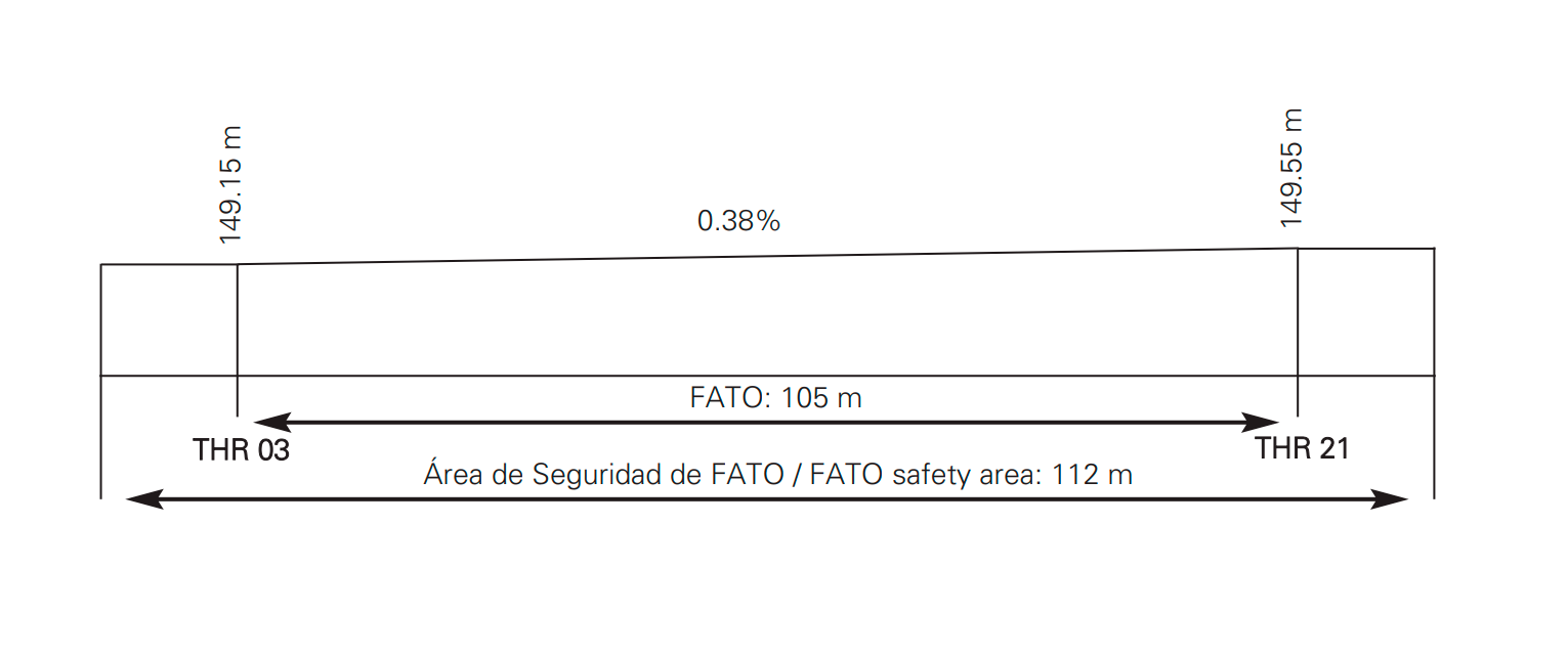
Magnetic heading: 028°-208°. Dimensions: 105 x 21 m. Surface: Asphalt. Strength: Maximum allowable mass 6 TM. Coordinates: 413426.0N 0021524.7E. Elevation: 149.5 m / 491 ft. |
|
Safety area dimensions |
112 x 28 m. |
|
Heliport CWY dimensions |
No. |
|
Obstacle-free sector |
Yes. |
|
Remarks |
None. |
profile
DECLARED DISTANCES
FATO |
TODAH (m) |
RTODAH (m) |
LDAH (m) |
|---|---|---|---|
03 |
105 |
105 |
105 |
21 |
105 |
105 |
105 |
Remarks: None.
APPROACH AND FATO LIGHTING
FATO |
03/21 |
|
Approach |
No. |
|
APAPI |
No. |
|
FATO lighting |
Characteristics: No. Location: None. |
|
Aiming point lighting |
Characteristics: No. Location: None. |
|
TLOF lighting |
Characteristics: Floodlighting poles. Location: AIO building. |
|
Remarks |
None. |
OTHER LIGHTING, SECONDARY POWER SUPPLY
Heliport beacon |
No. |
|
WDI/LDI |
1 near FATO. LGTD. |
|
TWY lighting |
No. |
|
Apron lighting |
Characteristics: No. Location: None. |
|
Secondary power supply |
No. |
|
|
Remarks |
None. |
Air traffic services airspaceATS AIRSPACE
|
Designation |
No. |
Lateral limits |
- |
|
Vertical limits |
- |
|
Airspace class |
- |
|
|
Unit Language |
- - |
Transition altitude |
- |
|
Hours of applicability |
- |
|
Remarks: |
- |
Air traffic services communication facilitiesATS COMMUNICATION FACILITIES
Service |
Call sign |
FREQ (MHz) |
HR |
Remarks |
|---|---|---|---|---|
No |
No |
122.800 |
HR HEL |
HEL without ATS service Only air/air communications |
RADIO NAVIGATION and landing aidsfacilities
Facility (VAR) |
ID |
FREQ |
HR |
Coordinates |
ELEV DME |
Remarks |
|---|---|---|---|---|---|---|
No |
- |
- |
- |
- |
- |
- |
LOCAL heliportREGULATIONS
Consult the NOTAM in force before operating on the infrastructure.
Take-off/landing shall only be permitted when the FATO is vacant.
Air taxiways for access to the TLOF stands from the FATO are defined:
-
Arrival manoeuvres: After final approach to the FATO, carry out air taxiing up to the indicated TLOF. Take the taxiway markings and the centre of the TLOF as visual references.
-
Departure manoeuvres: Air taxiing from the TLOF to the FATO following the taxiway markings.
For embarkation and disembarkation with rotors turning, the tail rotor must be facing the FATO.
OPERATIONAL MINIMA
The HEL shall only be operational under VFR conditions.
Take extreme care with winds exceeding 20 kts.
RESTRICTED USE OPERATION
Radio equipment is required for operating at the HEL.
Aircraft using this HEL are required to carry appropriate equipment to maintain a listening watch on frequency 122.800 MHz for self-coordination. They shall transmit their intentions as well as the evolution of the different phases of their flight on the same frequency, for the awareness and, where applicable, separation from other aircraft forming part of the aerodrome traffic.
PUBLIC USE OPERATION
When commercial passenger transport flights are required, activation of the heliport for public use must be requested at least 96 hours prior to the estimated time of operation, by email to ops@bghelicopters.com and confirmed by telephone at +34 935 167 044.
NOISE ABATEMENT PROCEDURES
No.
FLIGHT PROCEDURES
HEL TRAFFIC CIRCUIT
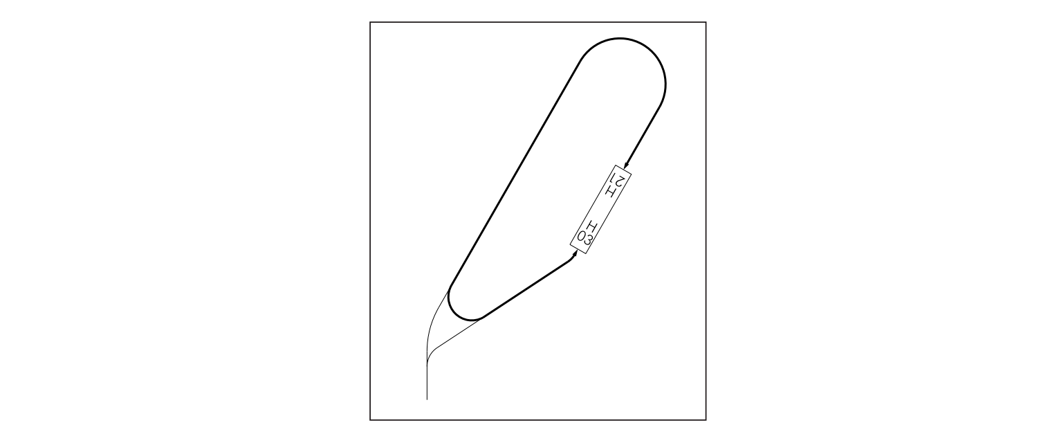
Remarks: Approaches for helicopters operating in Performance classes 1 and 2. For helicopters operating in Performance class 3, consult the heliport management in advance (see item 19).
ADDITIONAL INFORMATION
No.