LEAB AD 2 AERODROME DATA
AERODROME LOCATION INDICATOR - NAME
LEAB - ALBACETE
AERODROME GEOGRAPHICAL AND ADMINISTRATIVE DATA
ARP |
385655N 0015148W. See AD 2-LEAB ADC. |
|
Distance and direction from the city |
4 km S. |
|
Elevation |
701 m / 2301 ft. |
|
Geoid undulation |
51.92 ± 0.05 m. (1) |
|
Reference temperature |
33°C. |
|
Low average temperature |
5°C. |
|
Magnetic variation |
0° (2020). |
|
Annual change |
7.6’E. |
|
AD administration |
CIV: Aena. MIL: Ejército del Aire y del Espacio. |
|
Address |
Base Aérea de Albacete. MIL: 02071 - Albacete CIV: Crta. Peñas de San Pedro km. 4.5, 02049 - Albacete |
|
TEL |
CIV: +34-967 555 703 / 700 MIL: +34-967 556 549 |
|
FAX |
CIV: +34-967 555 716 MIL: +34-967 556 190 |
|
AFTN |
LEAB. |
|
|
CIV: opsleab@aena.es |
||
Approved traffic |
IFR/VFR. (2) |
|
Remarks |
(1) For all AD points. (2) VFR traffic restricted: See item 20. |
OPERATIONAL HOURS
Airport |
CIV: V: 0700-1230; I: 0800-1330. (4) (6). MIL: V: MON-THU: 0600-1230, FRI: 0600-1200; I: MON-THU: 0630-1400, FRI: 0630-1330. (1) (2). |
|
Customs and Immigration |
Customs:
Immigration:
|
|
Health and Sanitation |
CIV: No. MIL: H24. |
|
AIS/ARO/OPV |
HR AD. |
|
MET briefing |
CIV: HR AD. MIL: H24. |
|
ATS |
H24. |
|
Fuelling |
CIV: V: 0800-1200 I: 0900-1300 (5). MIL: H24 (7) (8). |
|
Handling |
CIV: HR AD (3). MIL: V: MON-THU: 0600-1230, FRI: 0600-1200; I: MON-THU: 0630-1400, FRI: 0630-1330. (1) (2). |
|
Security |
CIV: HR AD. MIL: H24. |
|
De-icing |
CIV: No. MIL: H24. |
|
Remarks |
(1) Exceptions:
(2) Foreign State aircraft shall request mandatory PPR at least 72 HR in advance. (3) Mandatory to request clearance 48 HR in advance from the LEAB Operations Office:
(4) Civil VFR flights will be authorized at the following times:
(5) Other times available on request, 24 HR in advance of refuelling:
(6) For IFR flights outside the civil schedule, it is mandatory to request authorization 96 HR in advance of the day of the programmed operation from LEAB Operations Office:
(7) Prior request for refuelling of JP8 fuel PPR at least 24 hours in advance. (8) Coordination with 60 minutes in advance is required, when national ambulance and/or organ transport flights request refuelling service.
|
HANDLING SERVICES AND FACILITIES
Cargo facilities |
MIL: Yes. |
|
Fuel types |
CIV: JET A-1 available for civil aircraft PPR requested 24 HR in advance from SITA ABCOPYA or FAX +34-967 555 716. MIL: F-34. |
|
Oil types |
MIL: G-353, G-354, G-392, G-395, H-515, O-123, S-720, S-743. |
|
Refuelling capacity |
CIV: Truck: 18000 L, 1.3 L/s. Tank: 30000 L. MIL: Truck: 40000 L, 22.5 L/s. 20000 L, 16.7 L/s. |
|
De-Icing facilities |
No. |
|
Hangar space |
No. |
|
Repair facilities |
No. |
|
Remarks |
Agreement with the handling agency is not mandatory for General Aviation operations. Ramp agent:
MIL: GPU: Unit of CA (until 45 KVA) and CC (up to 1500 A). Aircraft are required to have chocks available for refuelling or extended parking. |
PASSENGER FACILITIES
Hotels |
MIL: Military residence. On request. Subject to availability. |
|
Restaurant |
MIL: Military restaurant. On request. Subject to availability. |
|
Transportation |
CIV: Taxis. MIL: Military vehicles. On request. Subject to availability. |
|
Medical facilities |
MIL: First aid and ambulance. |
|
Bank/Post Office |
MIL: Cash dispenser / No. |
|
Tourist information |
No. |
|
Remarks |
None. |
RESCUE AND FIRE FIGHTING SERVICES
Fire category |
CIV: 5. MIL: MON-FRI, EXC HOL, 0800-1500 (LT): 7.- O/T: 5 (7 AVBL PPR 24 HR in advance). |
|
Rescue equipment |
In accordance with the fire category published. |
|
Removal of disabled aircraft |
CIV: Own equipment for removal aircraft up to 5 TM. MIL: Luna RSL 45/9000-A equipment with maximum hook capacity of 30 TM. |
|
Remarks |
None. |
SEASONAL AVAILABILITY/OBSTACLE CLEARING
Equipment |
MIL: Truck with snowplough spades and flux spreader, vacuum snow sweepers, backhoe digger and tow truck. |
|
Priority |
MIL: RWY, TWY and aprons. |
|
Remarks |
None. |
MOVEMENT AREA DETAILS
Apron |
Surface: Asphaltic concrete. Strength: Civil apron E-5: PCN 32/F/A/W/T. Military apron E-1: PCN 43/R/A/W/T. Military apron E-2: PCN 43/R/B/W/T. Military apron E-3: PCN 88/R/A/W/T. E-3.1: PCN 85/R/A/W/T. (The eastern area of apron E-3). Military apron E-4: PCN 82/R/A/W/T. |
|
Taxiways |
Width: 22.5 m. EXC: F: 23 m; G: 18 m; RE-1A: 21 m; RE-8, RE-9, RE-10: 25 m; RF1: 5.2 m. Surface: Asphaltic concrete. Strength: A, RE-5: PCN 23/F/B/W/T; B: PCN 46/F/A/W/T; C: PCN 26/F/A/W/T; D, R-2, R-3: PCN 43/F/B/W/T; E: PCN 50/F/B/W/T; F: PCN 32/F/A/W/T; G: PCN 87/F/B/W/T; R-1: PCN 43/F/B/W/T, PCN 51/F/A/W/T; R-4: PCN 43/F/B/W/T, PCN 55/F/B/W/T; RE-1: PCN 68/R/B/W/T; RE-1A: PCN 18/F/D/W/T; RE-2: PCN 102/F/A/W/T; RE-3: THEORETICAL PCN 54F/D/W/T; RE-4: PCN 10/F/C/W/T; RE-6 THEORETICAL PCN 32 F/A/W/T; RE-7: PCN 11/F/A/W/T; RE-8, RE-10: PCN 9/F/A/W/T; RE-9: PCN 12/F/A/W/T; RF1: PCN 41/F/B/W/T. |
|
Check locations |
Altimeter: Civil apron: ELEV 696 m / 2283 ft. VOR: THR 09 MARC 93.8° DIST 0.93 NM. THR 27 MARC 259.1° DIST 0.55 NM. INS: See AD 2-LEAB PDC. TACAN: THR 09 MARC 101.6° DIST 0.70 NM. ELEV 699 m / 2294 ft. THR 27 MARC 256.3° DIST 0.71 NM. ELEV 705 m / 2314 ft. |
|
Remarks |
None. |
TAXIING GUIDANCE SYSTEM AND MARKINGS
Taxiing guidance system |
Runway-holding positions, intermediate holding positions, boards and stands. |
|
RWY markings |
Designators, threshold, centre line, side stripe, touchdown zone and runway distance remaining boards (in thousands of feet). |
|
TWY markings |
Centre line, EXC G, RE-1A, RE-8, RE-9, RE-10. Side stripe in TWY A, B, C, D, E, F and RF1. |
|
Remarks |
None. |
AERODROME OBSTACLES
In approach and take-off areas |
In circling area and at AD |
|||
|---|---|---|---|---|
RWY Area |
Obstruction |
Coordinates |
Obstruction |
Coordinates |
09 |
Antenna |
385900.4N 0015509.7W |
Antenna 731 m / 2398 ft |
385713.1N 0015142.1W |
Remarks: See AD 2-LEAB AOC. |
||||
METEOROLOGICAL SERVICE PROVIDED
MET office |
CIV/MIL: Albacete OMD. |
|
HR |
H24. |
|
METAR |
Half-hourly. |
|
TAF |
24 HR. |
|
TREND |
Yes. |
|
Briefing |
In person and by telephone. |
|
Flight documentation/Language |
Charts and plain language/Spanish. |
|
Charts |
Significant and provided maps of wind and temperature at altitude. |
|
Supplementary equipment |
CIV: Aeronautical Meteorological Self-service and sensor data in real time. MIL: Aeronautical Meteorological Self-service. Sensor data in real time and satellites, cloud and lightning image and radar information display. |
|
ATS unit served |
TWR, APP, OPV. |
|
Additional information |
Madrid OMAe (LEMC): H24; TEL: +34-915 045 807 MIL (Albacete OMD): H24; TEL: +34-967 556 107 E-mail: omdleab@aemet.es |
|
Remarks |
Aerodrome climatological summary available. Aerodrome warnings available. |
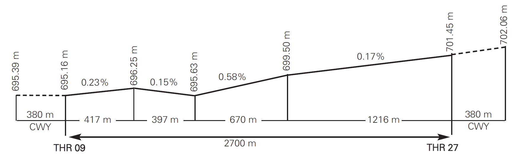
RUNWAY PHYSICAL CHARACTERISTICS
RWY |
Direction |
DIM (m) |
THR PSN |
THR ELEV TDZ ELEV |
SWY (m) |
CWY (m) |
Strip (m) |
OFZ |
RESA (m) |
RWY/SWY SFC PCN |
|---|---|---|---|---|---|---|---|---|---|---|
09 |
087.72° GEO 088° MAG |
2700 x 60 |
385652.68N 0015244.83W |
THR: 695.2 m / 2281 ft TDZ: 696.3 m / 2284 ft |
CIV: No MIL: 380x60 |
CIV: 380x150 MIL: 380x60 |
CIV: 2820x300 MIL: 3078x60 |
No |
No |
RWY: Asphaltic concrete PCN 94/F/A/W/T SWY CIV: No SWY MIL: Asphaltic concrete |
27 |
267.74° GEO 268° MAG |
2700 x 60 |
385656.14N 0015052.75W |
THR: 701.5 m / 2301 ft TDZ: 701.5 m / 2301 ft |
CIV: No MIL: 380x60 |
CIV: 380x150 MIL: 380x60 |
CIV: 2820x300 MIL: 3078x60 |
No |
No |
RWY: Asphaltic concrete PCN 94/F/A/W/T SWY CIV: No SWY MIL: Asphaltic concrete |
Remarks: Albacete Air Base airfield category 4D. |
||||||||||
Profile:
DECLARED DISTANCES
RWY |
TORA (m) |
TODA (m) |
ASDA (m) |
LDA (m) |
|---|---|---|---|---|
09 |
2700 |
3080 |
CIV: 2700 MIL: 3080 |
2700 |
27 |
2700 |
3080 |
CIV: 2700 MIL: 3080 |
2700 |
09 INT B |
1845 |
2225 |
CIV: 1845 MIL: 2225 |
- |
09 INT C |
1095 |
1475 |
CIV: 1095 MIL: 1475 |
- |
27 INT D |
2150 |
2530 |
CIV: 2150 MIL: 2530 |
- |
27 INT C |
1605 |
1985 |
CIV: 1605 MIL: 1985 |
- |
Remarks: None. |
||||
APPROACH AND RUNWAY LIGHTING
Runway |
09 |
|
Approach |
Threshold identification lights. |
|
PAPI (MEHT) |
3.0° (14.65 m / 48 ft). |
|
Threshold |
Green. |
|
Touchdown zone |
No. |
|
Runway centre line |
No. |
|
Runway edge |
White. (1) Distance between lights: 60 m. |
|
Runway end |
Red. |
|
Stopway |
No. |
|
Remarks |
(1) Adjustable light intensity. Lighted runway distance remaining boards (in thousands of feet). |
Runway |
27 |
|
Approach |
Threshold identification lights. |
|
PAPI (MEHT) |
3.0° (14.65 m / 48 ft). |
|
Threshold |
Green. |
|
Touchdown zone |
No. |
|
Runway centre line: |
No. |
|
Runway edge |
White. (1) Distance between lights: 60 m. |
|
Runway end |
Red. |
|
Stopway |
No. |
|
Remarks |
(1) Adjustable light intensity. Lighted runway distance remaining boards (in thousands of feet). |
OTHER LIGHTING, SECONDARY POWER SUPPLY
ABN/IBN |
No. |
|
WDI |
1 near THR 09, 1 near THR 27. No LGTD. |
|
TWY lighting |
Edge, EXC G, RE-1A, RE-8, RE-9, RE-10, RF1. |
|
Apron lighting: CIV/MIL |
Edge and floodlighting poles. |
|
Secondary power supply |
Engine generator of 1st general emergency of 1000 KW. Engine specific generator of 2nd emergency of 250 KW. Response time: immediately. |
|
Remarks |
None. |
HELICOPTER LANDING AREA
Position |
NIL. |
|
Elevation |
NIL. |
|
Dimensions, surface, maximum weight, marking |
NIL. |
|
Direction |
NIL. |
|
Declared distances |
NIL. |
|
Lighting |
NIL. |
|
Remarks |
None. |
ATS AIRSPACE
Designation |
CTR ALBACETE. |
|
Lateral limits |
Circle radius 6.5 NM centred on ARP. |
|
Vertical limits |
SFC-3500 ft AGL. |
|
Airspace class |
D. |
|
|
Unit Language |
ALBACETE APP. ES/EN |
|
Transition altitude |
1850 m/6000 ft. |
Designation |
ATZ ALBACETE. |
|
Lateral limits |
Círculo de 8 km de radio centrado en ARP. |
|
Vertical limits |
SFC-3000 ft HGT (2). |
|
Airspace class |
D. |
|
|
Unit Language |
ALBACETE TWR. ES/EN |
|
Transition altitude |
||
Remarks |
(1) Or the ground visibility, whichever is lower. (2) Or up to the cloud ceiling, whichever is lower. |
ATS COMMUNICATION FACILITIES
Service |
Call sign |
FREQ |
HR |
Remarks |
|---|---|---|---|---|
CTA/APP |
Albacete APP |
118.730 C |
H24 |
APP/H. |
139.305 C |
H24 |
APP/MIL. |
||
257.800 MHz |
H24 |
APP/MIL. |
||
278.025 MHz |
H24 |
APP/MIL. |
||
121.500 MHz |
H24 |
EMERG. |
||
243.000 MHz |
H24 |
EMERG. |
||
TWR |
Albacete TWR |
122.105 C |
H24 |
|
139.305 C |
H24 |
MIL. |
||
386.675 MHz |
H24 |
MIL. |
||
121.500 MHz |
H24 |
EMERG. |
||
243.000 MHz |
H24 |
EMERG. |
||
GCA/ASR |
Albacete GCA |
138.525 MHz |
(1) |
(1) HR: V: 0700-1230 (MON-FRI); I: 0800-1400 (MON-FRI). |
281.075 MHz |
||||
371.450 MHz |
||||
GCA/PAR |
Albacete PAR |
253.375 MHz |
(1) |
|
376.375 MHz |
||||
GND |
Albacete GND |
121.805 C |
H24 |
GND/CIV. |
278.650 MHz |
H24 |
GND/MIL. |
RADIO NAVIGATION & LANDING FACILITIES
Facility (VAR) |
ID |
FREQ |
HR |
Coordinates |
ELEV DME |
Remarks |
|---|---|---|---|---|---|---|
LOC 09 (1°W) |
IABT |
110.700 MHz |
H24 |
385656.7N 0015034.9W |
088° MAG / 426 m FM THR 27. |
|
ILS CAT I |
||||||
GP 09 |
330.200 MHz |
H24 |
385649.2N 0015231.4W |
3°; RDH 16.8 m; at 336 m FM THR 09 & 120 m FL RCL to the right in the direction of APCH. |
||
ILS/DME 09 |
IABT |
CH 44X |
H24 |
385649.2N 0015231.4W |
690 m |
REF DME THR 09. |
LOC 27 (0°) |
IAE |
109.700 MHz |
H24 |
385652.2N 0015301.6W |
268° MAG / 405 m FM THR 09. |
|
ILS CAT I |
||||||
GP 27 |
333.200 MHz |
H24 |
385651.8N 0015103.8W |
3°; RDH 13.6 m; at 272 m FM THR 27 & 122 m FM RCL to the left in the direction of APCH. |
||
ILS/DME 27 |
IAE |
CH 34X |
H24 |
385651.8N 0015103.8W |
699 m |
REF DME THR 27. |
DVOR (0°) |
VAB |
115.800 MHz |
H24 |
385649.6N 0015133.5W |
||
DME |
VAB |
CH 105X |
H24 |
385649.6N 0015133.5W |
690 m |
|
TACAN (0°) |
TAB |
CH 17X |
H24 |
385644.6N 0015148.4W |
690 m |
LOCAL REGULATIONS
No civil aircraft (IFR/VFR) shall be authorized to carry out practices of approaches, touch-downs or take-offs. Only the final touch-down will be authorized, and only provided that a flight plan with destination LEAB has been approved.
AD closed to aircraft without radio communication in both directions. Civil aircraft under VFR should be equipped with an SSR transponder.
For civil aircraft with MTOW greater than 15 TM, it is mandatory to request clearance 48 HR in advance from the LEAB Operations Office.
The first 395 m of RWY 09 and the final 395 m of RWY 27 are not usable by light aircraft with a tail skid, and/or those aircraft whose landing gear elements cannot clear a height of 20 cm above the ground, needed to clear LEAB-02-C-B bidirectional cable barrier.
In such cases the alternative taxiing procedure is:
Exit from RWY 27 shall be via TWY B, and then via R-1 to A, F and apron E5.
To enter RWY 09 proceed via TWY F, A, R-1 and B.
Civil training flights restricted (instrument approach to RWY 27 and RWY 09 not permitted) while military aircraft of the Albacete air base are in flight. Prior coordination between the civil AD operations office and the flight school operations office is recommended.
OPERATING PROCEDURE IN CASE OF ALTERNATE AIRPORT
Albacete Airport may be designated as an alternate airport in flight plans. Even so, Albacete Airport will only guarantee the handling of diverted aircraft within the airport's operating hours. In such cases, the aircraft shall contact TWR and TWR will inform the aircraft whether the airport is operational or not (following consultation with Albacete Airport Operations).
In the event that the aircraft estimates the arrival to be outside the airport's operating hours, the aircraft must be diverted to another alternate airport.
Extensions to the operating hours must be requested at least 96 hours in advance.
REDUCTION OF AVAILABLE PARKING ON APRON
Removal of PRKG 1, 1A, 1B, 1C, 2, 2A, 2B, 3, 4, 5 and 6 and their corresponding markings.
Instead, aircraft shall follow the provisional markings that demarcate the locations of the new provisional PRKG: A1, A2, A3, A4, B and C.
Code letter B and higher code letter aircraft (wingspan equal to or greater than 15 m) shall request guidance from TWR prior to entering the civil apron. Guidance will be available upon request for aircraft with smaller wingspans and shall be compulsory when parking code letter B or C aircraft on the apron.
In case of manoeuvres when entering and exiting the provisional parking, aircraft shall apply the minimum power required and shall stop if any potential hazard is detected in the manoeuvre, requiring the presence of airport staff.
TWY RF-1 to be used exclusively by Helicopters with AH pilots (AIRBUS HELICOPTER).
OPERATIONAL SAFETY REPORTS
Pilots/the operator shall report to the airport as soon as possible about any accidents, incidents, occurrences or events which may have a potential operational impact and in which they have been involved or witnessed. The aim of these reports is to compile the information in order to improve operational safety, besides from the compulsory reporting of the occurrence to the appropriate aeronautical authority. Data may be sent in any format, including at least the following information:
Date and time.
Site.
Parties involved (data used to identify vehicles, aircraft … involved).
Companies involved.
Description of the facts.
Any other data considered relevant (e.g. lighting conditions, weather, phase of the operation such as take-off/landing/stopover, pavement conditions …).
Contact e-mail address of the airport, for receiving operational safety reports: Seguridad_Operacional_ABC@aena.es
In addition to notifying the airport by means of the indicated system, it is necessary to send the same data to the email address of the air traffic service provider: seguridaddevueloala14@mde.es and ECTA_BA_ALBACETE@mde.es
NOISE ABATEMENT PROCEDURES
DEPARTURES
VFR departures RWY 09
SOUTH DEPARTURE:
Reach 1500 ft AGL as soon as possible and turn right to avoid overflying the town of Chinchilla.
Afterburner: Turn off as soon as possible (1500 ft AGL/300 IAS MAX).
Climb up to 5000 ft AGL as soon as possible in outbound vector and follow TWR instructions.
NORTH DEPARTURE:
Before take-off TWR will give notification of the state of the LED35 (activated/not activated).
Reach 1500 ft AGL as soon as possible and turn left to avoid overflying the industrial estates of Camporroso and Romica.
Afterburner: Turn off as soon as possible (1500 ft AGL/300 IAS MAX).
Climb up to 5000 ft AGL as soon as possible in outbound vector and follow TWR instructions.
VFR departures RWY 27
SOUTH DEPARTURE:
Reach 1500 ft AGL as soon as possible and turn left to avoid (as far as possible) overflying Aguas Nuevas.
Afterburner: Turn off as soon as possible (1500 ft AGL/300 IAS MAX).
Climb up to 5000 ft AGL as soon as possible in outbound vector and follow TWR instructions.
NORTH DEPARTURE:
Reach 1500 ft AGL as soon as possible and turn right at 4 NM to avoid overflying the industrial estate of Campollano and suburbs of Albacete.
Afterburner: Turn off as soon as possible (1500 ft AGL/300 IAS MAX).
Climb up to 5000 ft AGL as soon as possible in outbound vector and follow TWR instructions.
ENGINE TESTING
Engine tests at the fixed point will be restricted to those necessary to maintain the operating performance of the unit. They will be forbidden between sunset and sunrise. Technical engine tests are forbidden in aircraft stands and/or runway-holding areas unless they are specifically authorised by headquarters.
Location of the industrial estates:
Industrial estate Camporroso: 385631N 0014530W.
Industrial estate Romica: 390331N 0015016W.
FLIGHT PROCEDURES
LOW VISIBILITY PROCEDURES (LVP)
Low Visibility Procedures (LVP) are not available at Albacete airport.
RADAR DISPLAY SYSTEM
1. The use of the surveillance radar in the provision of the Aerodrome Control Service in the Control Tower of Albacete airport is authorised for performing the following functions, as is established in the Reglamento de la Circulación Aérea in force:
1.1 Radar assistance to aircraft on final approach.
1.2 Radar assistance to other aircraft in the vicinity of the aerodrome.
1.3 Establishing radar separation between succeeding departing aircraft; and
1.4 Providing navigation assistance to VFR flights.
2. The use of the surveillance radar display system installed at Albacete control tower is authorised for performing the following tasks:
2.1 Mode C: Once the level of accuracy of mode C information presented on the radar screen is checked, authorisation can be issued to aircraft in order to occupy altitudes vacated by the preceding aircraft.
2.2 Speed adjustment: based on the speed information presented in the radar screen, the controller may advise aircraft in the approach path to increase or decrease their speed.
2.3 Geographical separation: through the confirmation and/or notification given by the aircraft when crossing over a reporting point published in the AIP and represented in the radar presentation, the controller may authorise ascents or descents in accordance with the applicable geographical separation.
3. The use of the surveillance radar display system installed in Albacete approach unit is also cleared for exclusive military use, complying with the following parameters:
3.1 Minimum separation distance will be 8 NM.
3.2 Radar separation will only be provided between aircraft with mode 3/C transponder.
3.3 Radar information will be used to provide radar vectoring guidance for traffic arriving to final approach aids or to a point from which a precision radar approach, a procedure approach, or a visual approach can be made.
AD TRAFFIC CIRCUIT. CONVENTIONAL VFR ACFT.
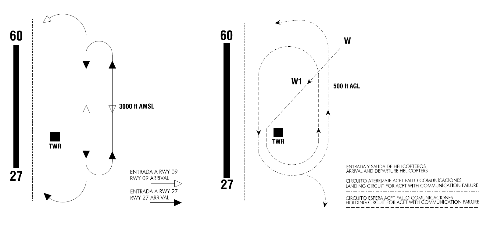
AD TRAFFIC CIRCUIT. JET AIRCRAFT
VFR JET AIRCRAFT RADIO FAILURE
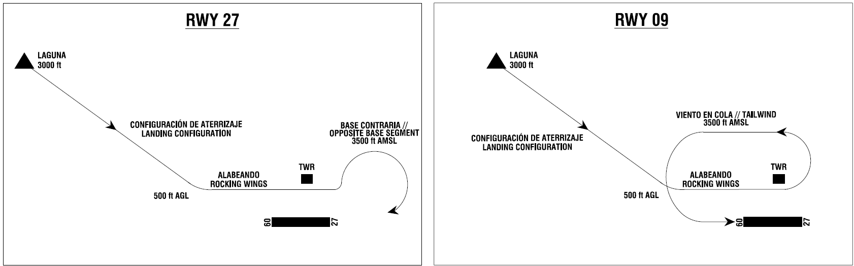
If any jet aircraft should experience radio failure while in VFR conditions, it shall set IFF/SIFF mode 3 A/C 7600 and proceed to LAGUNA point at 3000 ft AMSL.
From LAGUNA, it shall proceed to the threshold of RWY 09 descending to 500 ft AGL and turn towards the runway to pass between the taxiway and the Control Tower while rocking its wings, in landing configuration and with landing lights on. On this pass, the pilot shall check the runway in service (signs, barrier up, aerodrome traffic, etc.).
It shall maintain heading up to the threshold of RWY 27 and climb to 3500 ft AMSL to proceed with tailwind to the north of the runway in order to land on RWY 09, or to the right base segment for RWY 27.
If the green light is observed, it shall proceed to touch down. In case of no sighting or red light, it shall go around, clearing the runway at 500 ft AGL towards the Tower side, while rocking its wings again when reaching the Tower and maintain the traffic circuit at 500 ft AGL until greenlit.
ADDITIONAL INFORMATION
ARRESTING SYSTEMS
Nomenclature |
LEAB-01-R/C-U. |
|
Type |
NET AND CABLE BARRIER UNIDIRECTIONAL 44B-2E. |
|
Location on |
RED RWY 27 THR+2732m/8963ft. CABLE RWY 27 THR+2721m/8927ft. |
|
Readiness status |
Permanently available. |
Nomenclature |
LEAB-02-C-B. |
|
Type |
CABLE BARRIER BIDIRECTIONAL 500-S6. |
|
Location on |
RWY 09 THR+395m/1296ft. RWY 27 THR+2305m/7562ft. |
|
Readiness status |
Permanently available, except flight periods of TLP courses. |
Nomenclature |
LEAB-03-C-B. |
|
Type |
RETRACTABLE BIDIRECTIONAL CABLE BARRIER 500-S8. |
|
Location on |
RWY 09 THR+2059m/6755ft. RWY 27 THR+641m/2103ft. |
|
Readiness status |
Underhand, rising on request. |
Nomenclature |
LEAB-04-R/C-U. |
|
Type |
NET AND CABLE BARRIER UNIDIRECTIONAL 44B-2E. |
|
Location on |
RED RWY 09 THR+2730m/8957ft. CABLE RWY 09 THR+2719m/8920ft. |
|
Readiness status |
Permanently available. |
Radar instrument approach minima (Exclusive military use) |
||||||
RWY |
GP/TCH/RPI |
CAT |
DH/MDA-VIS |
HAT/HAA |
CEIL-VIS |
|
|---|---|---|---|---|---|---|
PAR |
09 |
3°/55/1050 |
ALL |
2478 |
200 |
200-1200 m |
SRE |
09 |
ALL |
2610 |
330 |
400-1600 m |
|
PAR |
27 |
3°/45/854 |
A B C D E HPMA |
2502 |
200 |
200-800 m |
SRE |
27 |
A B C HPMA |
2660 (1) |
358 |
400-1600 m |
|
D E |
2660 (1) |
358 |
400-1600 m (2) |
|||
CIR |
A |
2700 |
398 |
400-1600 m |
||
B |
2800 |
478 |
500-1600 m |
|||
C |
3150 |
848 |
900-4000 m |
|||
D |
3150 |
848 |
900-4400 m |
|||
E |
3690 |
1388 |
1400-4800 m |
|||
HPMA |
2920 |
618 |
700-3200 m |
|||
|
Remarks: (1) Do not descend from 3000 ft before 2.7 DME TAB (2.0 DME ILS 29). (2) With runway lights out of service, increase 400 m. OPR MON-FRI: 0700-1330 except holidays. TLP flight periods. |
||||||
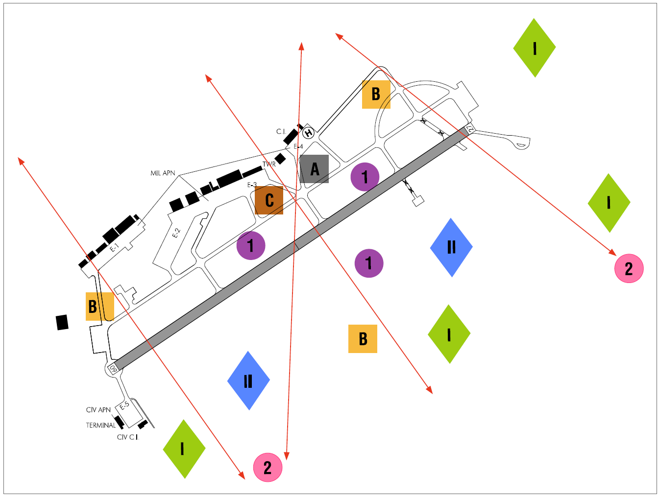
BIRD CONCENTRATION ZONES NEAR THE AIRPORT AREA
BIRD CONCENTRATION AREAS
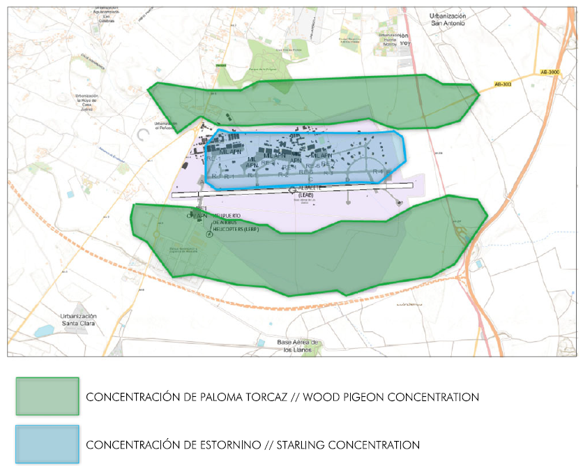
ZONE 1: Starlings.
ZONE 2: Wood pigeons and rock doves.
FEEDING ZONES
ZONE I: Cereal crops.
ZONE II: Invertebrates.
BIRD MOVEMENT ZONES
ZONE A: Birds of prey.
ZONE B: Wood pigeons and rock doves.
ZONE C: Starlings.
CHARTS RELATED TO THE AERODROME
The list of charts related to the aerodrome can be found on the link below:
VISUAL SEGMENT SURFACE (VSS) PENETRATION
Not applicable.