LERT AD 2 AERODROME DATA
AERODROME LOCATION INDICATOR - NAME
LERT - CÁDIZ/Rota
AERODROME GEOGRAPHICAL AND ADMINISTRATIVE DATA
ARP |
363843N 0062058W. See AD 2-LERT ADC. |
|
Distance and direction from the city |
2 km NE from Rota. |
|
Elevation |
26 m / 86 ft. |
|
Geoid undulation |
45.86 m ± 0.05 m. (1) |
|
Reference temperature |
24°C. |
|
Low average temperature |
10ºC. |
|
Magnetic variation |
1°W (2020). |
|
Annual change |
7.9’E. |
|
AD administration |
Armada Española. |
|
Address |
Armada Española: Jefatura aeródromo Militar B.N. Rota; 11530 - Rota-Naval (Cádiz). |
|
TEL |
+34-956 827 497 |
|
FAX |
+34-956 827 047 |
|
AFTN |
LERT |
|
Approved traffic |
IFR/VFR. Exclusive military use. (2) |
|
Remarks |
(1) For all AD points. (2) Spain-USA joint use aerodrome. USA State aircraft see FLIP DoD USA. |
OPERATIONAL HOURS
Airport |
H24. (1) |
|
Customs and Immigration |
Yes. (2) |
|
Health and Sanitation |
HR AD. |
|
AIS/ARO/OPV |
USA: H24. |
|
MET briefing |
HR AD. |
|
ATS |
HR AD. |
|
Fuelling |
USA: H24. |
|
Handling |
HR AD. |
|
Security |
H24. |
|
De-icing |
No. |
|
Remarks |
(1) USA State aircraft: PRECOPE diplomatic authorisation and PPR in accordance with FLIP DoD USA.
(3) Outside these hours, it will provide services during flights of Spanish and third nationality aircraft operating at LERT. Other hours available by 2 HR advance request to the LERT Aeronautical Information Office / Flight.
|
HANDLING SERVICES AND FACILITIES
Cargo facilities |
Yes. PPR. |
|
Fuel types |
F-34. |
|
Oil types |
INFO NO AVBL. |
|
Refuelling capacity |
Trucks: 20000 L & 40000 L: 16.66 L/s. |
|
De-Icing facilities |
No. |
|
Hangar space |
No. |
|
Repair facilities |
No. |
|
Remarks |
GPU: Alternating current (up to 1200 kVA) and direct current (up to 2500 A for 5 seconds / 1000 A continuous) units. |
PASSENGER FACILITIES
Hotels |
Yes. |
|
Restaurant |
Yes. |
|
Transportation |
Yes. PPR. |
|
Medical facilities |
First aids and motor ambulance. |
|
Bank/Post Office |
Yes. |
|
Tourist information |
No. |
|
Remarks |
None. |
RESCUE AND FIRE FIGHTING SERVICES
Fire category |
9. |
|
Rescue equipment |
In accordance with the fire category published. |
|
Removal of disabled aircraft |
Tractors with dragging bars. Flatbed tractor. |
|
Remarks |
None. |
SEASONAL AVAILABILITY/OBSTACLE CLEARING
Equipment |
Backhoe sweeper vehicle, front loader vehicle and self-propelled crane vehicle. |
|
Priority |
Runway and movement area. |
|
Remarks |
None. |
MOVEMENT AREA DETAILS
Apron |
Surface: Concrete. |
|
Taxiways |
Width: 20 m heliport. 23 m main aerodrome. |
|
Check locations |
Altimeter: 363808N 0062808W. ELEV 26 m/86 ft. TACAN: THR RWY 10 bearing 277°;THR RWY 28 bearing 108°. |
|
Remarks |
None. |
TAXIING GUIDANCE SYSTEM AND MARKINGS
Taxiing guidance system |
Runway-holding positions, boards and stands. |
|
RWY markings |
Designators, threshold, centre line, side stripe, touchdown zone and aiming point. |
|
TWY markings |
Centre line and side stripe. |
|
Remarks |
Inertial verification signal in north apron. The aiming point of RWY 28 is different from the PAPI. |
AERODROME OBSTACLES
In approach and take-off areas
RWY Area |
Obstruction |
Coordinates |
|---|---|---|
10 |
Antenna 191 m / 627 ft |
101° / 9.50 NM FM TACAN |
28 |
Antenna 45 m / 148 ft |
149° / 1.50 NM FM TACAN |
Transmission pole 155 m / 509 ft |
149° / 9.00 NM FM TACAN |
|
Transmission pole 155 m / 509 ft |
155° / 9.02 NM FM TACAN |
|
Water tank 82 m / 269 ft |
177° / 0.70 NM FM TACAN |
|
Antenna 70 m / 230 ft |
0.20 NM to N RWY |
|
Antenna 28.7 m / 94 ft |
363845N 0062157W |
In circling area and at AD
Obstruction |
Coordinates |
|---|---|
Foodlighting poles |
132º–147º / 0.6–0.7 NM FM TACAN |
Foodlighting poles in Haz Cargo 47 m / 140 ft |
087º / 0.7 NM FM TACAN |
Remarks: Aerial electricity cables cross the approach path to threshold RWY 28 in N/S direction, at 0.8 NM from the THR. Poles 37 m/121 ft height.
METEOROLOGICAL SERVICE PROVIDED
MET office |
Rota OMD. |
|
HR |
H24. |
|
METAR |
Half-hourly. |
|
TAF |
24 HR. |
|
TREND |
Yes. |
|
Briefing |
In person and by telephone.
|
|
Flight documentation/Language |
Charts and plain language/Spanish/English. |
|
Charts |
Significant, forecasted in altitude (wind and temperature) and maximum wind maps. |
|
Supplementary equipment |
Satellite images, lightning and radar information display. |
|
ATS unit served |
OPV, TWR. |
|
Additional information |
|
|
Remarks |
None. |
RUNWAY PHYSICAL CHARACTERISTICS
RWY |
Direction |
DIM (m) |
THR PSN |
TDZ ELEV |
SWY (m) |
CWY (m) |
Strip (m) |
OFZ |
RESA (m) |
RWY/SWY SFC PCN |
|---|---|---|---|---|---|---|---|---|---|---|
10 |
096.87°GEO 098°MAG |
3690 x 61 |
363849.93N 0062211.86W |
THR: 19.5 m / 64 ft |
45 x 61 |
122 x 61 |
No |
No |
No |
RWY: CONC/ASPH/CONC PCN 68/F/A/W/T PCN 06/R/B/W/T |
28 |
276.90°GEO 278°MAG |
3690 x 61 |
363835.58N 0061944.40W |
THR: 19 m / 62 ft |
45 x 61 |
122 x 61 |
No |
No |
No |
RWY: CONC/ASPH/CONC PCN 68/F/A/W/T PCN 06/R/B/W/T |
Remarks: None. |
||||||||||
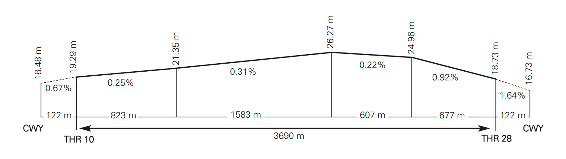
Profile:
DECLARED DISTANCES
RWY |
TORA (m) |
TODA (m) |
ASDA (m) |
LDA (m) |
|---|---|---|---|---|
10 |
3690 |
3812 |
3735 |
3690 |
28 |
3690 |
3812 |
3735 |
3690 |
Remarks: None. |
||||
APPROACH AND RUNWAY LIGHTING
Runway |
10 |
|
Approach |
No. |
|
PAPI (MEHT) |
3° (15.24 m / 50 ft), north of the runway. |
|
Threshold |
Green. |
|
Touchdown zone |
No. |
|
Runway centre line |
No. |
|
Runway edge |
3690 m white. LIH. (1) Distance between lights: 61 m. |
|
Runway end |
Red. |
|
Stopway |
No. |
|
Remarks |
(1) Adjustable intensity lights. |
Runway |
28 |
|
Approach |
No. |
|
PAPI (MEHT) |
2.75° (36.57 m / 120 ft), south of the runway. |
|
Threshold |
Green. |
|
Touchdown zone |
No. |
|
Runway centre line |
No. |
|
Runway edge |
3690 m white. LIH. (1) Distance between lights: 61 m. |
|
Runway end |
Red. |
|
Stopway |
No. |
|
Remarks |
(1) Adjustable intensity lights. |
OTHER LIGHTING, SECONDARY POWER SUPPLY
ABN |
ALTN FLG W/G EV 9s. HN. See AD 2-LERT ADC. |
|
WDI |
1 near ARP. LGTD. |
|
TWY lighting |
Edge. |
|
Apron lighting |
Edge. |
|
Secondary power supply |
Standby equipment that provides to the whole lighting system a maximum time of connection (light) of 15 seconds, according to Annex 14. |
|
Remarks |
Aerodrome beacon of height 269 ft SE of TWR. |
HELICOPTER LANDING AREA
Position |
HRP: 363823N 0061947W. |
|
Elevation |
23 m/74 ft. |
|
Dimensions, surface, maximum weight, marking |
558 x 40 m. Asphalt. PCN 34/R/B/W/T |
|
Direction |
10-28. |
|
Declared distances |
INFO NO AVBL. |
|
RWY 10H/28H lighting |
|
|
Remarks |
Zone for exclusive use of the Armada and third nationalities; 7 spots (stands) on VFR runway for helicopters 10H/28H. |
ATS AIRSPACE
Designation and lateral limits |
Vertical limits |
Airspace class |
Unit / Language |
Transition altitude |
||
CTR ROTA — Circle radius 6.5 NM centred on ARP. (1) |
SFC-1000 ft AGL |
D |
SEVILLA APP ES/EN |
6000 ft |
||
ATZ ROTA — Circle maximum variable radius 10 km centred on ARP. (2) |
SFC-3000 ft HGT |
D |
ROTA TWR ES/EN |
6000 ft |
||
Remarks |
(1) Delegation from SEVILLA ACC to ROTA TWR. (See ENR 2.2). (2) Or the ground visibility, whichever is lower. (3) Or up to the clouds ceiling, whichever is lower. |
|||||
ATS COMMUNICATION FACILITIES
Service |
Call sign |
FREQ |
HR |
Remarks |
|---|---|---|---|---|
APP |
SEVILLA APP |
120.800 MHz; 128.500 MHz; 264.700 MHz; 279.000 MHz |
H24 H24 |
APP/L |
TWR |
ROTA TWR |
119.750 MHz; 122.100 MHz; 139.300 MHz; 257.800 MHz; 344.225 MHz |
H24 H24 |
TWR TWR |
TWR |
ROTA TWR |
121.500 MHz; 243.000 MHz |
H24 |
EMERG |
TWR |
ROTA HLP |
122.225 MHz; 378.250 MHz |
(1) |
(1) V: MON-FRI EXC HOL: 0600-1230; I: MON-FRI EXC HOL: 0700-1330. O/T heliport controlled on ROTA TWR frequencies. |
GND |
ROTA GND |
130.700 MHz; 317.500 MHz; 265.925 MHz |
H24 H24 |
GMC PRI |
ATIS |
|
267.600 MHz |
H24 |
|
GCA |
ROTA GCA |
123.300 MHz; 134.100 MHz; 244.700 MHz; 356.050 MHz; 356.325 MHz; 369.225 MHz; 371.850 MHz |
(2) |
(2) V: MON-FRI EXC HOL: 0600-1230; I: MON-FRI EXC HOL: 0700-1330. O/T when visibility is less than 1.6 km and/or the cloud ceiling is less than 400 ft. |
RADIO NAVIGATION & LANDING FACILITIES
Facility (VAR) |
ID |
FREQ |
HR |
Coordinates |
DME ELEV |
Remarks |
|---|---|---|---|---|---|---|
TACAN (1°W) |
AOG |
CH 23X |
H24 |
363852.3N 0062056.6W |
34.76 m / 114 ft |
|
LOC 10 (1°W) |
IAOG |
108.700 MHz |
H24 |
363833.6N 0061924.4W |
20.73 m / 68 ft |
098° MAG / 501 m FM THR 28. |
ILS CAT I |
ILS U/S due to maintenance every Thursday 0800-1200. Usable PPR 20 MIN. |
|||||
GP 10 |
|
333.100 MHz |
H24 |
363845.5N 0062159.2W |
34.40 m / 113 ft |
3°; RDH 15.2 m at 327 m FM THR 10 & 98 m FM RCL to the right on APCH direction. |
RADAR DASR-11 |
ASR |
See item 18 |
See item 23 |
363904.06N 0062057.06W |
50.29 m / 165 ft |
|
RADAR PAR |
PAR |
See item 18 |
See item 23 |
363848.25N 0062112.66W |
30.44 m / 100 ft |
LOCAL REGULATIONS
Spain-USA joint use aerodrome. Military use only.
USA STATE AIRCRAFT
Mandatory to hold Diplomatic Authorisation from Spain-USA Permanent Committee (PRECOPE) and PPR request in accordance with the aeronautical information publications of the Department of Defense of the USA.
THIRD NATIONALITY STATE AIRCRAFT
Mandatory to hold Diplomatic Authorisation and PPR request at least 48 HR in advance. (1)
SPANISH CIVIL AIRCRAFT
Mandatory to hold authorisation from the Estado Mayor de la Armada and PPR request at least 48 HR in advance. (1)
Remarks: (1) The PPR request may be directed to the LERT Aeronautical Information Office.
- TEL: +34-956 827 497
- FAX: +34-956 827 047
- AFTN: LERT
- E-mail: oficina_aeronautica_rota@mde.es
NOISE ABATEMENT PROCEDURES
High-power tests shall be performed on request.
- HR V: 0500-2000, I: 0600-2100.
- Spots (stands) 40, 41 and 42.
FLIGHT PROCEDURES
LOW VISIBILITY PROCEDURES (LVP)
RWY 10 is equipped with ILS CAT I and, likewise, RWY 10/28 is authorised for low visibility take-offs (LVTO).
PHASES
a) Preparation phase: When the visibility conditions have deteriorated noticeably, to 1000 m or less, the Preparation phase will be established. The ATC Service will inform the aircraft affected.
b) Activation phase:Low visibility procedures (LVP) shall be applied when any of the following conditions is met:
-
When any transmissometer indicates an RVR of 600 m or less.
-
When the visibility is less than 600 m (in cases of transmissometer failure).
-
When the weather conditions are deteriorating rapidly and this is advisable.
The ATC Service will inform the aircraft affected by radiotelephone that the low visibility procedures are being applied. This information will be recorded in the ATIS system.
c) Cancellation phase:The Low Visibility Procedures will be cancelled when the following conditions are met:
-
When all the transmissometers indicate RVR above 1000 m, or visibility above 1000 m (if the latter are out of service).
-
Clear and favourable improving trend in the weather conditions for a period of at least 10 minutes.
SURFACE MOVEMENTS
a)As a general rule, while the Low Visibility Procedures (LVP) are in force, only one aircraft will be cleared to taxi at a time in the manoeuvring area.
b)Pilots and/or drivers shall proceed to verify the situation of the aircraft at all times, ensuring that taxiing takes place under conditions of complete safety. In the event of disorientation or doubt they shall halt the aircraft/vehicle and notify the Control Tower immediately.
c) Arrivals:
-
An aircraft that has landed, after reporting “RUNWAY VACATED”, shall hold and await taxiing instructions.
-
On entering the parking apron, it shall await the presence of the "FOLLOW ME" vehicle for guidance to the assigned stand. It shall report “FOLLOW ME IN SIGHT” and “TAXIWAY VACATED” to TWR.
d) Departures:
-
Pilots shall request clearance for start-up or taxiing, reporting the spot (stand) and apron exit taxiway requested.
-
When the Low Visibility Procedures are in force, normally only one aircraft will be cleared to taxi in the manoeuvring area at a time.
-
In the event that an aircraft has to return to the apron, the pilot shall inform the tower and await new instructions.
COMMUNICATIONS FAILURE
a) In the case of a departing/arriving aircraft, this shall continue with the designated route up to the clearance limit, taking extreme care and not deviating from the route. Once there, it shall hold until the arrival of a "FOLLOW ME" vehicle.
b)Vehicles with communications failure shall leave the zone not permitted immediately (taxiways, main runway, etc.) and await the arrival of a "FOLLOW ME" vehicle.
SAFETY
a) If in doubt about the position in the manoeuvring area, the pilot must halt the aircraft and report this circumstance to the Tower, including the last known position.
b)The "FOLLOW ME" vehicle shall be available for the guidance of aircraft both in arrivals and departures upon request by the commander.
c)The movement of vehicles in the manoeuvring area shall be restricted to the minimum indispensable.
d)Any incident which could affect the Low Visibility Procedures (LVP) shall be notified immediately to all the aircraft affected so they can take the appropriate measures.
AD TRAFFIC CIRCUIT
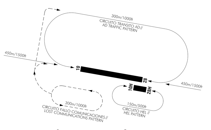
Remarks:
- Break-up procedure authorised for tactical military jet aircraft only.
- Jet aircraft entering break-up shall proceed from an initial point at 5 NM from AOG and 2500 ft, descending to 1500 ft over the threshold of the runway in service. Break-up shall be performed with the interval in sight or following the TWR instructions, levelled at 1500 ft and descending to the traffic height once established in the tailwind segment.
ADDITIONAL INFORMATION
ARRESTING GEAR
-
E-28 (B) 701.00 m FM THR 28.
-
E-28 (B) 1067.00 m FM THR 10.
Remarks: The normal situation of the arresting gear is NOT DEPLOYED. Verify the status of the E-28 cable prior to arrival with ATIS or on the TWR frequency.
Radar instrument approach minima
ROTA GCA (1) (7) ASR 344.0 134 1 (2) 259.0 (2)
RWY |
GP/TCH/RPI |
CAT |
DH/MDA – VIS |
HAT/HAA |
CEIL – VIS |
|
|---|---|---|---|---|---|---|
PAR |
10 (3) |
3.0° / 55 / 986 |
A B C D E HPMA |
264 – 1200 m |
200 |
(200 – 1200 m) |
28 (4) (5) |
2.75° / 128 / 2216 |
A B C D E HPMA |
262 – 1200 m |
200 |
(200 – 1200 m) |
|
ASR |
10 |
A B C D E HPMA |
440 – 1600 m |
369 |
(400 – 1600 m) |
|
28 (5) |
A B C D E HPMA |
380 – 1600 m |
316 |
(400 – 1600 m) |
||
CIR |
10–28 (6) |
A |
520 – 1600 m |
440 |
(500 – 1600 m) |
|
B |
580 – 1600 m |
500 |
(500 – 1600 m) |
|||
C |
680 – 2400 m |
600 |
(600 – 2400 m) |
|||
D |
960 – 4400 m |
880 |
(900 – 4400 m) |
|||
E |
1060 – 4800 m |
980 |
(1000 – 4800 m) |
|||
HPMA |
640 – 2800 m |
560 |
(600 – 2800 m) |
Remarks
- Maintenance of the PAR / ASR every Monday HR V: 0900-1300, I: 0800-1200 under VMC. If ASR is unserviceable, PAR is unavailable.
- Back-up GCA.
- PAR RPI and PAPI RPI are different.
- Caution: PAR glide path and PAPI glide path are different.
- First 2000 ft of RWY 28 have a rising slope of 0.97%.
- Circuit south of RWY 10/28 not authorised.
- GCA available. HR V: MON-FRI EXC HOL: 0600-1230; I: MON-FRI EXC HOL: 0700-1330. O/T when the visibility is less than 1.6 km and/or the cloud ceiling is less than 400 ft.
- The activation schedule for Delegated Airspace (EAD) shall be H24, on request from ROTA TWR, coordinated in advance with SEVILLA ACC, communicated at least 5 minutes in advance, and during the period necessary for performing radar approach operations (PAR/ASR)
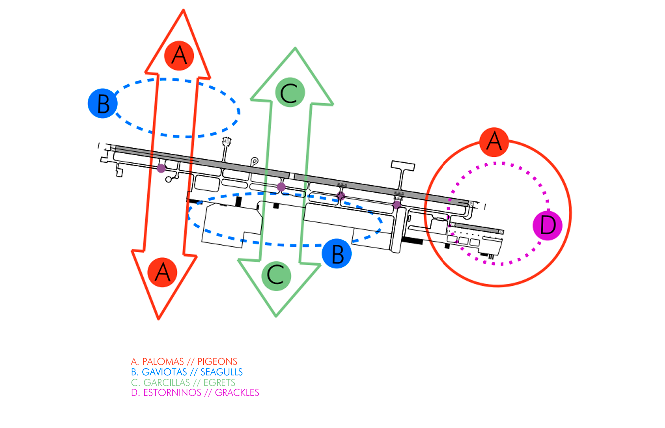
BIRDS CONCENTRATION AREA
Caution in landing and taking-off operations by RWY 10/28 due to birds concentration in the vicinity of the aerodrome.
A: Crossing of pigeons during the whole year (special intensity between May and September).
B: Sporadic crossing of seagulls in stormy days.
C: Crossing of egrets during the whole year.
D: Crossing of grackles between November and December.
CHARTS RELATED TO THE AERODROME
The list of charts related to the aerodrome can be found on the link below:
VISUAL SEGMENT SURFACE (VSS) PENETRATION
Not applicable.