GCHI AD 2 AERODROME DATA
AERODROME LOCATION INDICATOR - NAME
GCHI - EL HIERRO
AERODROME GEOGRAPHICAL AND ADMINISTRATIVE DATA
| ARP | 274853N 0175313W. See AD 2-GCHI ADC. | |
| Distance and direction from the city | 9 km NE. | |
| Elevation | 32 m / 106 ft. | |
| Geoid undulation | 39.50 m ± 0.05 m. (1) | |
| Reference temperature | 27°C. | |
| Low average temperature | 18ºC. | |
| Magnetic variation | 5°W (2020). | |
| Annual change | 10.2’ E. | |
| AD administration | Aena | |
| Address | Aeropuerto de El Hierro 38910, Valverde, El Hierro. | |
| TEL | +34-922 553 707 | |
| FAX | +34-922 553 731 | |
| AFTN | GCHI | |
| vde.coord@aena.es | ||
| Approved traffic | IFR/VFR. (2) | |
| Remarks |
SITA: VDEOPYA.
(1) For all AD points. (2) General Aviation IFR/VFR traffic (except hospital, military, search and rescue and State aircraft) apron parking restricted except by prior request 24 HR in advance to vde.coord@aena.es or TEL: +34-922 553 707 and confirmation from this AD coordination office. |
OPERATIONAL HOURS
| Airport |
V: 0710-1700 EXC JUL, AUG and SEP 0710-1800, PS 90 MIN.
I: 0810-1800. PS 90 MIN. |
|
| Customs and Immigration | No. | |
| Health and Sanitation | No. | |
| AIS/ARO | H24 (1) | |
| MET briefing | HR AD PS 40 MIN BFR. | |
| ATS |
HR AFIS: SAT and SUN: HR AD. (2)
HR TWR: From MON to FRI: HR AD. (2) PS 90 MIN PPR. |
|
| Fuelling | No. | |
| Handling | HR AD. | |
| Security | HR AD. | |
| De-icing | No. | |
| Remarks |
(1) Centralised ARO office, geographical area 15.
Centralised AIO Office - International NOTAM Office. (2) See items 18 and 20. |
HANDLING SERVICES AND FACILITIES
| Cargo facilities | No. | |
| Fuel types | No. | |
| Oil types | No. | |
| Refuelling capacity | No. | |
| De-icing facilities | No. | |
| Hangar space | No. | |
| Repair facilities | No. | |
| Remarks |
Ramp agents:
Ramp agents may attend both Commercial and General Aviation. |
PASSENGER FACILITIES
| Hotels | No. | |
| Restaurant | Yes. | |
| Transportation | Bus, taxis and hire cars. | |
| Medical facilities | No. | |
| Bank/Post Office | No. | |
| Tourist information | Yes. | |
| Remarks | None. |
RESCUE AND FIRE FIGHTING SERVICES
| Fire category | 5. | |
| Rescue equipment | According to the fire category published. | |
| Removal of disabled aircraft | 2 dollies for rescue up to 10 TM, lifting and towing equipment for CAT I and II and AETS10 aircraft. | |
| Remarks |
Telephone and e-mail address of the aerodrome coordinator for transferring unused aircraft in the manoeuvring area or nearby:
|
RUNWAY SURFACE CONDITION ASSESSMENT AND REPORTING AND SNOW PLAN
| Types of clearing equipment | Not applicable. | |
| Clearance priorities | Not applicable. | |
| Use of material for surface treatment | Not applicable. | |
| Specially prepared winter runways | Not applicable. | |
| Remarks |
Runway surface condition assessment and reporting in accordance with the Global Reporting Format (GRF) methodology described in (AD 1.2.2). Aerodrome in service during all seasons of the year. |
MOVEMENT AREA DETAILS
| Apron | Surface: Flexible asphalt. Strength: PCN 14/F/C/W/T (PRKG 1 and 1A); PCN 26/F/A/W/T (PRKG 2, 2A, 3 and 3A). | |
| Taxiways |
Width: TWY A: 16.56 TWY B: 11.77 TWY C: 12.04 TWY D: 15.25. Surface: Asphalt. Strength : TWY A: PCN 14/F/C/W/T. TWY B, C and D: PCN 26/F/A/W/T. |
|
| Check locations |
Altimeter: Apron ELEV: 30 m/98 ft. VOR: No. INS: No. |
|
| Remarks | None. |
TAXIING GUIDANCE SYSTEM AND MARKINGS
Taxiing guidance system |
Horizontal marks, runway-holding positions, runway guard lights (1), information boards and stands. |
|
RWY markings |
Designators, threshold, centre line, side stripe, touchdown zone and aiming point. |
|
TWY markings |
Centre line and side stripe. |
|
Remarks |
(1) LED lighting. |
AERODROME OBSTACLES
Obstacles which penetrate Approach, Take-Off Climb, Conical, Inner Horizontal, Transitional, Inner Transitional and Balked Landing Surfaces established in ICAO Annex 14; and the areas 2A and 3 established in ICAO Annex 15. Those penetrating these surfaces are identified in the CSV file as “Relevante_Relevant = Si/Yes”. |
See Item 10 and Data Set. |
|
Remarks: |
See AD 2-GCHI AOC. |
METEOROLOGICAL SERVICE PROVIDED
| MET office | El Hierro EMAe. | |
| HR | HR AD PS 40 MIN BFR. Outside this schedule, a half-hourly METAR AUTO will be issued. | |
| METAR | Half-hourly. | |
| TAF | 24 HR. | |
| TREND | No. | |
| Briefing | In person and by telephone. | |
| Flight documentation/Language | Charts and plain language / Spanish. | |
| Charts | Significant, forecast at altitude (wind and temperature) maps. | |
| Supplementary equipment | No. | |
| ATS unit served | AFIS, TWR. | |
| Additional information |
Las Palmas OMAe (GCGC): H24
El Hierro EMAe: HR AD
|
|
| Remarks | Aerodrome climatological summary available. Aerodrome warnings available. |
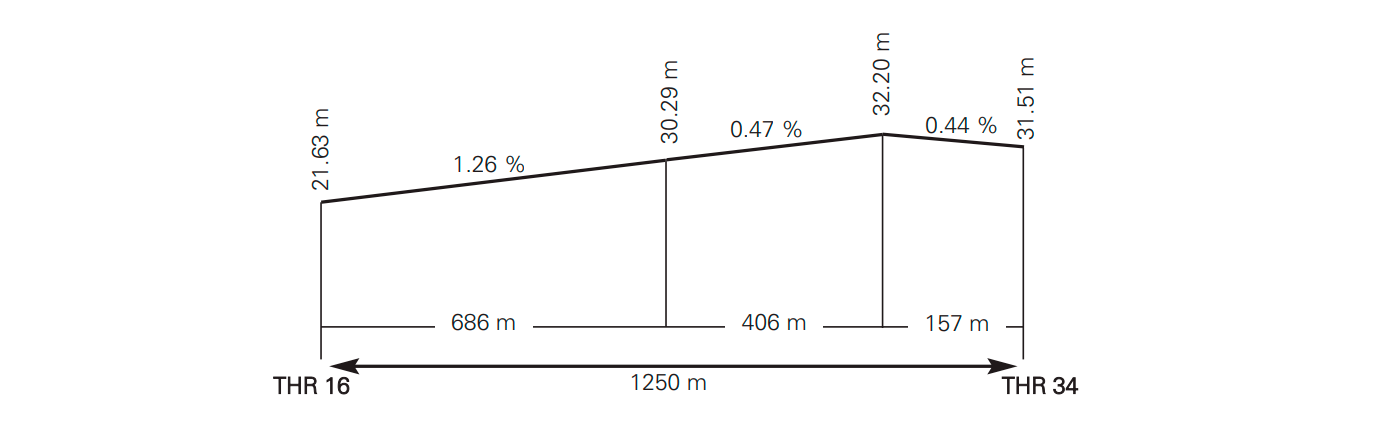
RUNWAY PHYSICAL CHARACTERISTICS
| RWY | Direction | DIM (m) | THR PSN | THR ELEV / TDZ ELEV | SWY (m) | CWY (m) | Strip (m) | OFZ | RESA (m) | RWY/SWY SFC PCN |
|---|---|---|---|---|---|---|---|---|---|---|
| 16 |
152.57° GEO
158° MAG |
1250 x 30 | 274911.46N 0175323.91W |
THR: 22 m / 71 ft.
TDZ: No |
No | No | 1310 x 75 | No | No |
RWY: ASPH PCN 26/F/A/W/T (1)
SWY: No |
| 34 |
332.57° GEO
338° MAG |
1250 x 30 | 274835.43N 0175302.89W |
THR: 32 m / 103 ft.
TDZ: No |
No | No | 1310 x 75 | No | No |
RWY: ASPH PCN 26/F/A/W/T (1)
SWY: No |
Remarks:(1) First 85 m RWY 16 PCN 42/R/C/W/T. First 150 m RWY 34 PCN 11/F/A/W/T. |
||||||||||
Profile
DECLARED DISTANCES
| RWY | TORA (m) | TODA (m) | ASDA (m) | LDA (m) |
|---|---|---|---|---|
| 16 | 1250 | 1250 | 1250 | 1250 |
| 34 | 1250 | 1250 | 1250 | 1250 |
Remarks: None |
||||
APPROACH AND RUNWAY LIGHTING
Runway |
16 |
|
Approach |
Threshold identification lights. |
|
PAPI (MEHT) |
3° (7.90 m/26 ft). (1) |
|
Threshold |
Green with wing bars. |
|
Touchdown zone |
No. |
|
Runway centre line |
No. |
|
Runway edge |
1250 m: 850 m white + 400 m yellow. LIM
|
|
Runway end |
Red.
|
|
Stopway |
No. |
|
Remarks |
Switch on of lights by radio outside operational hours by frequency 118.100 MHZ. Adjustable light intensity. (1) Angular coverage restricted to 4.8º to the right side of RCL in direction of APCH. |
Runway |
34 |
|
Approach |
Threshold identification lights. |
|
PAPI (MEHT) |
3° (8.00 m/26 ft). |
|
Threshold |
Green with wing bars. |
|
Touchdown zone |
No. |
|
Runway centre line |
No. |
|
Runway edge |
1250 m: 850 m white + 400 m yellow. LIM.
|
|
Runway end |
Red.
|
|
Stopway |
No. |
|
Remarks |
Switch on of lights by radio outside operational hours by frequency 118.100 MHZ. Adjustable light intensity. |
OTHER LIGHTING, SECONDARY POWER SUPPLY
ABN/IBN |
No. |
|
WDI |
1 near THR 16, 1 near THR 34. LGTD. |
|
TWY lighting |
Edge. |
|
Apron lighting |
Edge (1) and floodlighting pole in PRKG 1 and 1A. |
|
Secondary power supply |
Engine generators which provide a switch-over time (light) of 15 seconds and an uninterruptible power supply which provides a maximum switchover time (light) of 1 second for the following lighting systems: Runway edge, runway end, threshold, threshold identification lights, taxiway edge, apron edge and runway protection lights. |
|
Remarks |
(1) Adjustable light intensity. |
HELICOPTER LANDING AREA
Location |
FATO: RWY 16/34. Coordinates THR 16 and THR 34, see item 12. Ground taxiing: TLOF coincides with RWY 16/34, see item 12. Air taxiing: TLOF coincides with PRKG 1 and 3. See AD 2-GCHI PDC. |
|
Elevation |
FATO: RWY 16/34. Elevation THR 16 and THR 34, see item 12. Ground taxiing: TLOF coincides with RWY 16/34, see item 12. Air taxiing: TLOF coincides with PRKG 1 and 3. AD 2-GCHI PDC. |
|
Dimensions, surface, maximum weight, marking |
FATO: RWY 16/34. Ground taxiing: TLOF coincides as RWY 16/34, see item 12. Air taxiing: TLOF coincides with PRKG 1 and 3. AD 2-GCHI PDC. |
|
Direction |
No. |
|
Declared distances |
No. |
|
Lighting |
Floodlighting poles in PRKG 1. |
|
Remarks |
For air taxiing, AS32 and B412 helicopters shall taxi exclusively via TWY A and D. |
ATS AIRSPACE
Designation |
FIZ HIERRO (RMZ) (FPMZ). (1)
|
|
| Lateral limits | 275457N 0175947W, 275716N 0175446W; 275353N 0175248W from this point following arc of 5 NM centred on ARP, 275113N 0174813W, 274315N 0174332W, 273953N 0175051W, 274352N 0175310W, from this point following arc of 5 NM centred on ARP, 275142N 0175753W, 275457N 0175947W. |
|
|
Vertical limits Airspace class |
SFC-2700 ft AMSL... G. |
|
Unit / Language |
HIERRO AFIS. ES/EN |
|
Transition altitude |
1850 m/6000 ft |
Designation |
CTR HIERRO (2). |
|
| Lateral limits | Lateral limits coincide with those published for FIZ HIERRO. |
|
|
Vertical limits Airspace class |
SFC-2700 ft AMSL... D. |
|
Unit / Language |
CANARIAS APP. ES/EN |
|
Transition altitude |
|
Designation |
ATZ HIERRO . |
|
| Lateral limits | Circle radius 8 km centred on ARP (3). |
|
|
Vertical limits Airspace class |
SFC-1800 ft AMSL (4)... D. |
|
Unit / Language |
HIERRO TWR. ES/EN |
|
Transition altitude |
|
|
Remarks |
(1) During AFIS HR. Flight plan submission mandatory zone.
|
ATS COMMUNICATION FACILITIES
| Service | Call sign | FREQ | HR | Remarks |
|---|---|---|---|---|
| APP | Canarias APP |
125.350 MHz
126.100 MHz 133.675 MHz |
H24
H24 H24 |
BACK-UP |
| TWR | Hierro TWR | 118.075 MHz | HR TWR (1) | ATZ and CTR during TWR HR. (1) See item 3. |
| AFIS | Hierro Información |
118.075 MHz
121.500 MHz |
HR AFIS (1)
HR AD |
FIZ during AFIS HR.
EMERG |
RADIO NAVIGATION & LANDING FACILITIES
| Facility (VAR) | ID | FREQ | HR | Coordinates | DME ELEV | Remarks |
|---|---|---|---|---|---|---|
| NDB (5º W) | HIE | 376.000 kHz | H24 | 274858.2N 0175311.0W | - | - |
| DME | HR |
CH 79X
113.20 MHz |
H24 | 274857.8N 0175311.2W | 30 m | U/S BTN: 215º/310º |
LOCAL REGULATIONS
Control service is not provided out of TWR operational hours. AFIS service is provided during AFIS operational hours (see items 3 and 18). Parking guidance service will be provided to aircraft of non-customary air carriers and when requested by the flight crew. See AFIS procedures in ENR 1.5 and AD 1.1. Operations by aircraft with ACN ( aircraft classification number) 12 on RWY 16/34 are allowed. Microlight operations are not allowed.
It is mandatory to submit a flight plan and be equipped with two-way radio communications when AFIS service is provided within the FIZ. Only one IFR operation will be allowed at a time within the FIZ.
When the change of the service provided is expected to coincide with an aircraft operation,at the airport or within its airspace, the ATS unit concerned will inform pilots about the type of service supplied.
Instrument approaches are to be used solely under VMC conditions in the surroundings of the aerodrome, since it is certified with a visual flight runway.
OPERATIONAL SAFETY REPORTS
Pilots/operator shall report to the airport as soon as possible about any accidents, incidents, occurrences or events which may have a potential operational impact and in which they have been involved or witnessed.
The aim of these reports is the compilation of the information in order to improve operational safety, independently of the mandatory reporting of the occurrence to the appropriate aeronautical authority. Data may be sent in any format, including at least the following information:
- Date and time.
- Site.
- Parties involved (data used to identify vehicles, aircraft…involved).
- Companies implicated.
- Description of the facts.
- Any other data considered relevant (e.g. lighting conditions, weather, phase of the operation such as take-off / landing / stopover, pavement conditions…).
Contact e-mail address of the airport, for the reception of operational safety reports, is the following: Seguridad_Operacional_VDE@aena.es
In addition to notifying the airport by means of the indicated system, it is necessary to send at least basic data of the accident, incident, occurrence or event to the air traffic control service provider (ATC).
AIRCRAFT WITH LANDING GEAR WIDTH HIGHER THAN THE AT72's
Aircraft with landing gear width higher than the AT72's, must coordinate the operation with vde.coord@aena.es and TEL:+34-922 553 707.
NOISE ABATEMENT PROCEDURES
No.
FLIGHT PROCEDURES
OPERATIONAL STANDSTILL PROCEDURE IN THE MOVEMENT AREA (PPOAM)
Operations are not permitted when the RVR is less than 550 m (VIS less than 800 m if the RVR value is not available).
LOW VISIBILITY PROCEDURES (LVP)
Low Visibility Procedures (LVP) are not available at El Hierro airport.
RADAR DISPLAY SYSTEM
ATS staff will maintain all operations conducted at or near the aerodrome under constant visual surveillance, having an ATS Surveillance System to support said visual surveillance, as established in Article 4.5.1.3 of the Reglamento de la Circulación Aérea.
This is subject to limitations and availability of equipment.
AD TRAFFIC CIRCUIT

ADDITIONAL INFORMATION
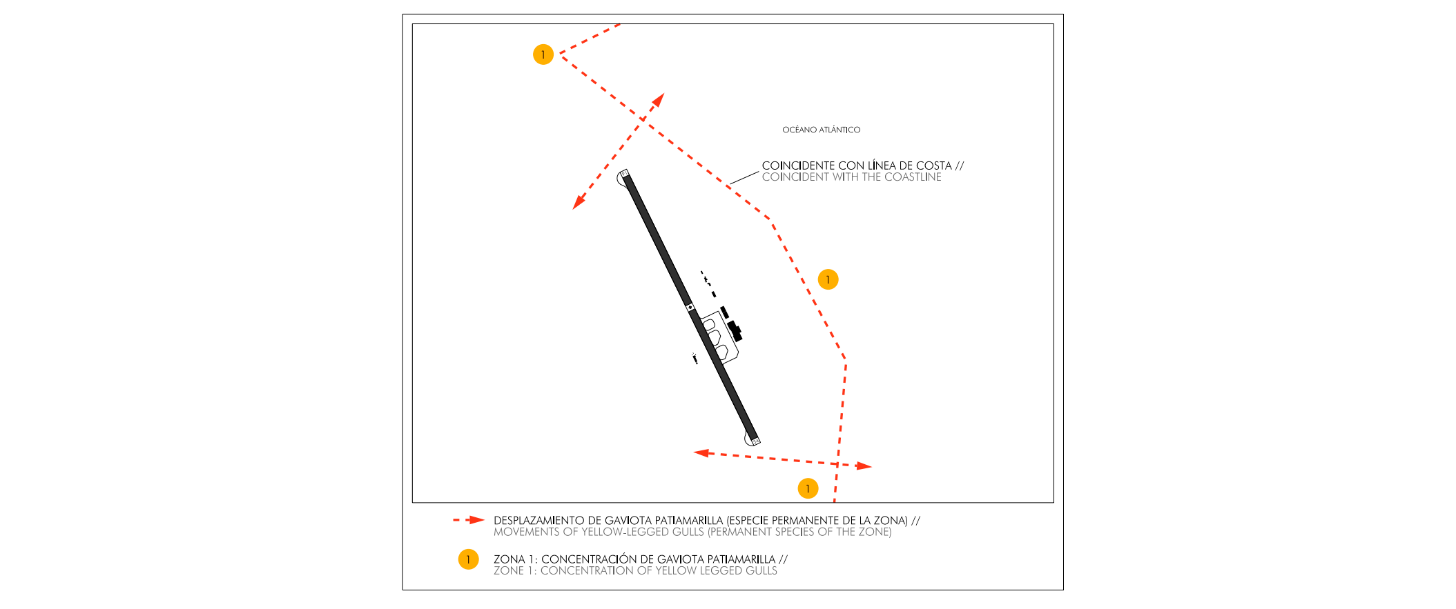
BIRD CONCENTRATION ZONES
The following bird concentration zone lies close to the airport grounds:
- Zone 1: Concentration of yellow‐legged gulls. This zone is made up of the cliffs, coastal rocks, inter‐tidal zones, fishing area of Tamaduste and the La Estaca harbour.
BIRD MOVEMENTS
Movements of yellow-legged gulls (permanent species of the zone).
WIND PHENOMENA
- A major operational problem is the variability of the wind; on many occasions it is oscillating in direction, often within the first quadrant.
- It is recommended not to perform the approach with a hillside wind between 280º and 320º and an intensity above 10 kt, due to the presence of a very strong mountain wave. (1)
- Equally, with winds between 330º and 350º with intensities greater than 15 kt, if moderate turbulence is experienced on short final, missed approach must be executed since tailwinds may be encountered at 50 ft height. (2)
- In summer, with winds from 020º to 060º and intensities between 20 kt and 30 kt or more, there will be strong downdrafts at THR 34. (3)
With any of the winds mentioned above, strong turbulence should be expected after take-off, so it is recommended, once this has been accomplished, to turn as soon as possible towards the sea.

ELECTRONIC FLIGHT INSTRUMENT SYSTEM (EFIS) ERROR WARNINGS
Error warnings are occasionally displayed at the RWY 34 threshold in the “EFIS comparison” display or “heading disagree” with regard to the magnetic heading, as both EFIS are not aligned.
CHARTS RELATED TO THE AERODROME
The list of charts related to the aerodrome can be found on the link below:
VISUAL SEGMENT SURFACE (VSS) PENETRATION
Not applicable.