AERODROME LOCATION INDICATOR AND NAME
LERL - CIUDAD REAL
AERODROME GEOGRAPHICAL AND ADMINISTRATIVE DATA
| ARP | 385123N 0035812W. See AD 2-LERL ADC. | |
| Distance and direction from the city | 15 km S. | |
| Elevation | 646 m / 2120 ft. | |
| Geoid undulation | 50.0 m ± 0.5 m (1). | |
| Reference temperature | 34ºC. | |
| Low average temperature | 6ºC. | |
| Magnetic variation | 0º (2025). | |
| Annual change | 9.3'E. | |
| AD administration | Ciudad Real International Airport. | |
| Address | Aeropuerto de Ciudad Real - Autovía Ciudad Real-Puertollano s/n. 13434 Ciudad Real. |
|
| TEL | +34-926 841 818 | |
| FAX | +34-926 841 713 | |
| AFTN | LERL | |
| ceops@airportcria.com | ||
| Approved traffic | VFR. (2) | |
| Remarks | (1) For all AD points. (2) See item 20. Local Regulations. |
OPERATIONAL HOURS
| Airport | HR AD (Public use): V: MON-SUN: on request SR-SS. (1). I: MON-SUN: on request SR-SS. (1). HR AD (Restricted use): V: MON-FRI: 0800 - 1500; SAT and SUN: On demand. (2). I: MON-FRI: 0900 - 1600; SAT and SUN: On demand. (2). |
|
| Customs and Immigration | HR AD. | |
| Health and Sanitation | No. | |
| AIS | HR AD. | |
| ARO | HR AD. | |
| MET briefing | No. | |
| ATS | No. | |
| Fuelling | HR AD (PPR 48h). | |
| Handling | HR AD (uso público). | |
| Security | H24. | |
| De-icing | No. | |
| Remarks | (1) (2) See item 20. Local Regulations. (1) The airport may be opened for public use when the airport operations office is requested by the air carrier 72 HR in advance. The opening shall be effective when it is expressly confirmed by the airport operations office. Public use operational hours are set by NOTAM, and therefore the current NOTAM must be consulted. The NOTAM will be published at least 24 HR in advance. Exceptionally and in cases of emergencies or unforeseen situations, the NOTAM may be published up to 6 HR prior to the activation of public use. (2) During the restricted use of the airport, the following operations by aircraft with code letter up to 2C will be permitted: general aviation, flight training, aerial work, and flights for line or base maintenance, emergency and medical evacuation flights. For any operation during restricted use hours, a request must be submitted at least 24 HR in advance. The operation will be subject to explicit confirmation by the airport operations office. The airport may be opened under restricted use outside these hours, between CCM and CCV at the latest, upon request submitted by the air carrier to the airport operations office at least 24 HR in advance. Confirmation from the airport operations office will be required for the opening to be effective. |
HANDLING SERVICES AND FACILITIES
| Cargo facilities | Cargo terminal 8000 m2. | |
| Fuel types | JET A-1. | |
| Oil types | AEROSHELL W100. | |
| Refuelling capacity | JET A-1: 2 trucks 30000 L, 25 L/s.. | |
| De-icing facilities | No. | |
| Hangar space | No. | |
| Repair facilities | No. | |
| Remarks | Ramp agents: General and executive aviation handling: SMIA, S.L.:
Commercial aviation handling: SMIA, S.L.:
Refuelling available on request 48 HR in advance. |
PASSENGER FACILITIES
| Hotels | No. | |
| Restaurant | No. | |
| Transportation | Taxi. | |
| Medical facilities | First aid. | |
| Bank/Post Office | No / No. | |
| Tourist information | No. | |
| Remarks | None. |
RESCUE AND FIREFIGHTING SERVICES
| Fire category | Public use HR AD: 5 (1). Restricted use HR AD: means for restricted-use aerodrome. |
|
| Rescue equipment | In accordance with the fire category published. | |
| Removal of disabled aircraft | External service: Crane trucks external to the AD with a maximum lifting capacity of 120 TM. (2) | |
| Remarks | (1) Operational objective of response time to ends of RWY 10/28 of less than 3 MIN. (2) Withdrawal notice number (Operations centre):
|
RUNWAY SURFACE CONDITION ASSESSMENT AND REPORTING, AND SNOW PLAN
| Types of clearing equipment | Not applicable. | |
| Clearance priorities | Not applicable. | |
| Use of material for movement area surface treatment | Not applicable. | |
| Specially prepared winter runways | Not applicable. | |
| Remarks | Runway surface condition assessment and reporting in accordance with the Global Reporting Format (GRF) methodology described in AD 1.2.2. Aerodrome in service during all seasons of the year. |
APRONS, TAXIWAYS AND CHECK LOCATIONS/POSITIONS DATA
| Apron | Commercial Aviation: Southwest area PCN 77/R/B/W/T. |
|
| Taxiways | Width:25 m. A: PCN 77/R/B/W/T. |
|
| Check locations | Altimeter: Apron ELEV 622 m/2041 ft. VOR: No. INS: No. |
|
| Remarks | None. |
SURFACE MOVEMENT GUIDANCE AND CONTROL SYSTEM AND MARKINGS
| Taxiing guidance system | NO ENTRY boards, runway-holding positions, intermediate holding positions, stands. | |
| RWY markings | Designators, threshold, displaced threshold RWY 28, centre line, edge, side stripe, aiming point, touchdown zone and making rapid exit indicators. | |
| TWY markings | Centre line. (1) | |
| Remarks | (1) The taxiway edge is marked by elevated, omnidirectional retroreflective, non-electric beacons, blue in colour. |
AERODROME OBSTACLES
| Obstacles which penetrate Approach, Take-off climb, Conical, Inner Horizontal and Transitional Surfaces contained in Annex 14 of ICAO; and areas 2A and 3 contained in Annex 15 of ICAO: | See Item 10 and Data Set. | |
| Remarks | See AD 2-LERL AOC. |
METEOROLOGICAL INFORMATION PROVIDED
| MET office | No. | |
| HR | No. | |
| METAR | No. | |
| TAF | No. | |
| TREND | No. | |
| Information | No. | |
| Flight documentation/Language | No. | |
| Charts | No. | |
| Supplementary equipment | No. | |
| ATS unit served | No. | |
| Additional information | No. |
|
| Remarks | No. |
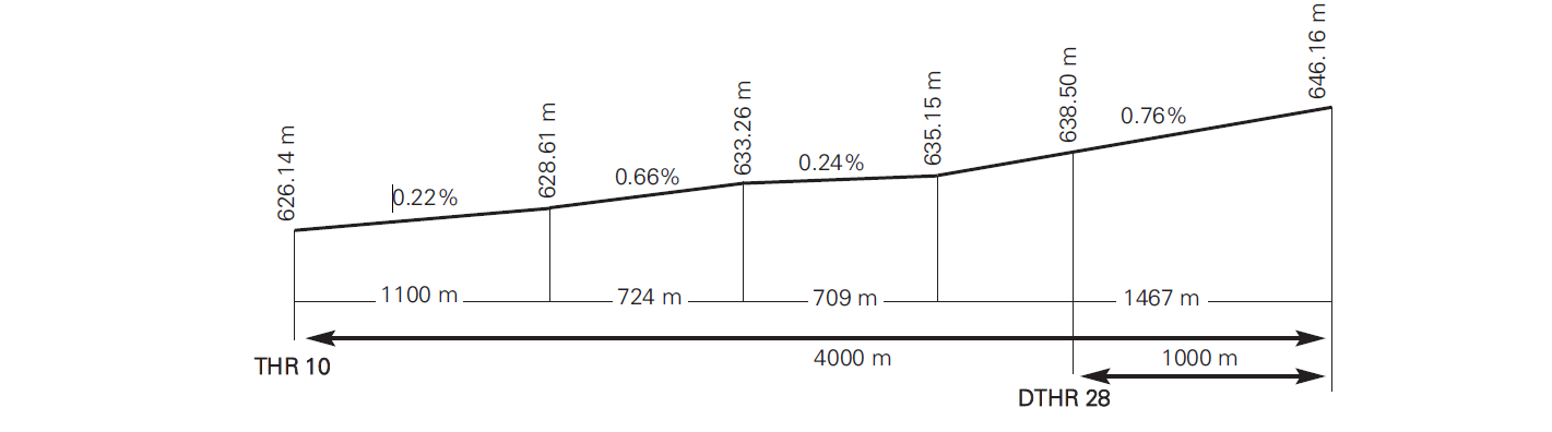
RUNWAY PHYSICAL CHARACTERISTICS
| RWY | Direction | DIM (m) | THR PSN | THR ELEV / TDZ ELEV | SWY (m) | CWY (m) | Strip (m) | OFZ | RESA (m) | RWY/SWY SFC PCN |
|---|---|---|---|---|---|---|---|---|---|---|
| 10 (1) | 102.58°GEO / 102°MAG | 4000 x 60 | 385137.56N 0035933.18W | THR: 626.1 m/2054 ft TDZ: 627.1 m/2057 ft |
60 x 60 | 60 x 150 | 4240 x 150 | No | 240 x 150 | RWY: ASPH PCN 123/F/A/W/T — SWY: No |
| 28 (2) | 282.60°GEO / 282°MAG | 4000 x 60 | 385116.36N 0035731.76W | THR: 639 m/2095 ft TDZ: 634.8 m/2083 ft |
60 x 60 | 60 x 150 | 4240 x 150 | No | 240 x 150 | RWY: ASPH PCN 123/F/A/W/T — SWY: No |
Remarks:
(1) End RWY 10 coordinates: 385109.29N 0035651.29W.
(2) THR RWY 28 displaced 1000 m.
Profile
DECLARED DISTANCES
| RWY | TORA (m) | TODA (m) | ASDA (m) | LDA (m) |
|---|---|---|---|---|
| 10 | 4000 | 4060 | 4060 | 4000 |
| 28 | 4000 | 4060 | 4060 | 3000 |
| 28 INT E-3 | 3000 | 3060 | 3060 | NU |
Remarks:None.
APPROACH AND RUNWAY LIGHTING
| Runway | 10 | |
| Approach | No. | |
| PAPI (MEHT) | 3° (21.67 m/71 ft). (1) | |
| Threshold | No. | |
| Touchdown zone | No. | |
| Runway centre line | No. | |
| Runway edge | No. | |
| Runway end | No. | |
| Stopway | No. | |
| Remarks | NIL. |
| Runway | 28 | |
| Approach | No. | |
| PAPI (MEHT) | 3° (21.46 m/70 ft). | |
| Threshold | No. | |
| Touchdown zone | No. | |
| Runway centre line | No. | |
| Runway edge | No. | |
| Runway end | No. | |
| Stopway | No. | |
| Remarks | NIL. |
OTHER LIGHTING, SECONDARY POWER SUPPLY
| ABN/IBN | No. | |
| WDI | 1 near THR 10 and other near THR 28. | |
| TWY lighting | No. | |
| Apron lighting | No. | |
| Secondary power supply | Engine generators that provide a maximum switchover (light) time of 15 seconds, according to Annex 14. | |
| Remarks | None. |
HELICOPTER LANDING AREA
| Position | No. | |
| Elevation | No. | |
| Dimensions, surface, maximum weight, marking | No. | |
| Direction | No. | |
| Declared distances | No. | |
| Lighting | No. | |
| Remarks | None. |
AIR TRAFFIC SERVICES AIRSPACE
Designation |
FIZ CIUDAD REAL (1) (RMZ) (FPMZ) (2). |
|
Lateral limits |
385431N 0040320W, from this point following arc of 5 NM centre on ARP, up to 385201N 0035149W, 385431N 0040320W. |
|
Vertical limits |
SFC-4000 ft AMSL. |
|
Airspace class |
G. |
|
Unit Language |
None. None. |
|
Transition altitude |
1850 m/6000 ft. |
|
Hours of applicability |
|
|
Remarks |
(1) Deactivated. (2) RMZ, FPMZ: During the public and restricted-use hours of the aerodrome. |
AIR TRAFFIC SERVICES COMMUNICATION FACILITIES
| Service | Call sign | FREQ | HR | Remarks |
|---|---|---|---|---|
| 118.055 C | HR AD | Only Air/Air communications. | ||
| No. | No. | 121.500 MHz | HR AD | EMERG. |
RADIO NAVIGATION AND LANDING AIDS
| Facility (VAR) | ID | FREQ | HR | Coordinates | DME ELEV | Remarks |
|---|---|---|---|---|---|---|
| No. |
LOCAL AERODROME REGULATIONS
Night operations are not authorised.
Operations for commercial air transport of passengers are not permitted.
The aerodrome is closed to aircraft without two-way radio communications on the relevant frequency.
Submission of a flight plan is mandatory.
Ultralight operations are not permitted.
Helicopter operations are not permitted.
The rapid exit taxiway is for aircraft up to code letter D.
Departures from RWY 28 shall be carried out from the intersection with TWY E3.
Runway access and exit shall be carried out via TWY E1.
TWY E2 and TWY E3 is only for aircraft taxiing to the RESTRICTED AREA.
RWY 10 shall be preferred provided the tailwind component does not exceed 10 kt on a dry runway, or on a wet runway with good braking action.
Pilots shall vacate the runway promptly, provided operational safety conditions allow.
No visual docking guidance system is available.
GENERAL TAXI PROCEDURES
Avoiding collisions with other aircraft or obstacles is the responsibility of the aircraft operator while taxiing on the apron, and of the ground handling agent, if any, during pushback, towing, or departure from the parking stand. Restrictions for taxiing on the apron with reference to aircraft wingspan are indicated by surface markings.
ENTRY TO RESTRICTED AREA
Taxiing and routing to the RESTRICTED AREA shall be conducted under “FOLLOW ME” vehicle escort up to the “NO ENTRY” ground marking, where the aircraft shall stop and shut down engines following instructions from the ground handling agent.
EXIT FROM RESTRICTED AREA
Engine start on TWY T1 or T3 must be coordinated with the ground handling agent.
RADIO FAILURE ON MANOEUVRING AREA
In the event that an aircraft or vehicle operating on the manoeuvring area experiences a communications failure, the following procedures shall apply:
- Aircraft departing: Hold position and await the arrival of a “FOLLOW ME” vehicle which will guide it to the parking position assigned by the appropriate authority.
- Aircraft just landed: Hold position on the first section of taxiway and await the arrival of a “FOLLOW ME” vehicle which will guide it to the parking position assigned by the appropriate authority.
- Vehicle: Vacate the “no stay” zone by the nearest exit available from its position, never crossing the runway. If unsure about vacating the “no stay” zone, hold position and await the “FOLLOW ME” vehicle for assistance.
RESTRICTED USE OPERATIONS
A prior request must be submitted at least 24 hours in advance. Operations are subject to explicit confirmation by the airport operations office CEOPS. The aircraft operator or pilot shall submit the request via:
- E-mail: ceops@airportcria.com
- Date of operation.
- Aircraft identification.
- Aircraft type.
- Planned dates and times.
- Origin and destination.
The request shall include:
During restricted use of the airport, aircraft operations up to code letter 2C are permitted for: general aviation, flight schools, aerial work, line or base maintenance flights, urgent and emergency medical transport.
ARRIVALS DURING RESTRICTED USE
- Notify Ciudad Real Airport by phone (TEL: +34-926 838 032) prior to departure. Departure to Ciudad Real Airport shall not occur until contact has been made.
- The airport will advise the aircraft by telephone of the pre-assigned parking stand, after verifying its availability.
- NOTE: If TEOPS (Operational Technician) identifies in real time that the preassigned parking stand is not available, TEOPS will guide the aircraft from TWY E1 to a new parking stand.
- Report arrival on frequency 118.055 C, in compliance with VFR arrival procedures as indicated on the airport’s visual approach chart.
- Remain listening on the previous frequency until fully parked.
- The pilot-in-command shall vacate the runway and taxi across the manoeuvring area and apron to the assigned parking stand following the visual guidance.
DEPARTURES DURING RESTRICTED USE
- Notify TEOPS by phone or in person if required (TEL: +34 926 838 032).
- Report start-up prior to departure on frequency 118.055 C, in compliance with VFR departure procedures indicated on the airport’s visual approach chart.
- Remain listening on the aforementioned frequency.
PUBLIC USE OPERATIONS
A prior request must be submitted at least 72 hours in advance. Operations are subject to explicit confirmation by the airport operations office. The operator or pilot shall submit the request via:
- E-mail: ceops@airportcria.com
- Date of operation.
- Aircraft identification.
- Aircraft type.
- Planned dates and times.
- Origin and destination.
The request shall include:
During public use, only aircraft with a maximum MTOW of 5700 kg or a maximum seating configuration of nine seats are permitted. A ground handling agent is mandatory for all public use operations.
ARRIVALS DURING PUBLIC USE
- Aircraft shall report on frequency 118.055 C after landing, indicating runway vacated and taxiway used.
- Taxiing to the parking position shall be conducted under “FOLLOW ME” escort from TWY E1.
- Crew shall wait at the parking stand for the ground handling agent.
- The ramp technician shall supervise the parking manoeuvre and ensure that safety measures regarding separation margins and FOD control are kept.
DEPARTURES DURING PUBLIC USE
- Aircraft shall be ready for pushback, towing, or taxi within 5 minutes of the approved startup time; otherwise, the pilot shall notify CEOPS.
- Pilots shall report startup or taxi on frequency 118.055 C, indicating their
parking position and aircraft call sign or registration.
- For all autonomous departures, pilots are responsible for vacating the stand following apron guidance.
- For tractor-assisted departures, the main landing gear shall be aligned on the taxiway centreline, with possible adjustment of the longitudinal axis angle.
- The ground handling coordinator is responsible for ensuring safe aircraft movement and that engine blast does not pose a risk to personnel, equipment, or other aircraft parked or manoeuvring.
- Aircraft shall proceed to a runway-holding position following surface markings and report position and intentions on frequency 118.055 C.
NOISE ABATEMENT PROCEDURES
ENGINE TESTS
Engine tests may be conducted under restricted use only with prior authorisation from the aerodrome, which will specify the procedure and the area designated for the tests.
Requests for authorisation to conduct engine tests must be submitted by telephone at least 24 hours in advance, including the following information::
- Start time.
- End time.
- Date of accomplishment.
- Air carrier.
- Aircraft model.
- Registration.
- Type of test: APU, idling, above idling
- CEOPS TEL: +34-926 838 032
FLIGHT PROCEDURES
LOW VISIBILITY PROCEDURES (LVP)
Low Visibility Procedures (LVP) are not available at Ciudad Real airport.
COMMUNICATIONS FAILURE
In the event of an aircraft operating in the monoeuvring area experiences a communications failure, it will contact with CEOPS holding position and waiting until the arrival of a vehicle which will guide the aircraft to the parking position.
AD TRAFFIC CIRCUIT

ADDITIONAL INFORMATION
Fauna control service is available in HR AD.
Fog is recorded with a certain frequency between the months from November to February.
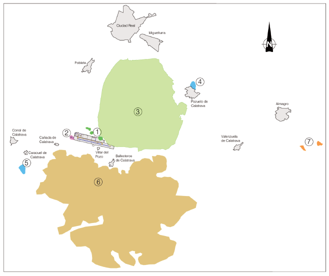
BIRD CONCENTRATION AREAS
- Area 1: Olive Groves.
- Area 2: Oak Grove.
- Area 3: ZEPA (Special protection área for birds).
- Area 4: Prado Lagoon.
- Area 5: Caracuel Lagoon.
- Area 6: Calatrava Mountain range.
- Area 7: Almagro Landfill.
AERONAUTICAL CHARTS RELATED TO AN AERODROME
The list of charts related to the aerodrome can be found on the link below:
VISUAL SEGMENT SURFACE (VSS) PENETRATION
Not applicable.