GCGM AD 2 AERODROME DATA
AERODROME LOCATION INDICATOR AND NAME
GCGM - LA GOMERA
AERODROME GEOGRAPHICAL AND ADMINISTRATIVE DATA
| ARP | 280147N 0171253W. See AD 2-GCGM ADC. | |
| Distance and direction from the city | 34 km SW. | |
| Elevation | 218 m/716 ft. | |
| Geoid undulation | 43.7 m ± 0.05 m (1). | |
| Reference temperature | 27°C. | |
| Low average temperature | 18ºC. | |
| Magnetic variation | 5ºW (2020). | |
| Annual change | 9.6'E | |
| AD administration | Aena. | |
| Address | Aeropuerto de La Gomera - 38812 Alajeró - La Gomera | |
| TEL | +34-922 873 000 | |
| FAX | +34-922 873 002 | |
| AFTN | GCGM | |
| cecoaqgz@aena.es | ||
| Approved traffic | VFR | |
| Remarks | (1) For all AD points. |
OPERATIONAL HOURS
| Airport | V: 0700-1700; I: 0800-1800. PS TIL SS PPR (1) |
|
| Customs and Immigration | No. | |
| Health and Sanitation | No. | |
| AIS/ARO | H24 (2) | |
| MET briefing | V: 0600-1700; I: 0700-1800 PS TIL SS PPR. | |
| ATS | HR AD. (3) | |
| Fuelling | No. | |
| Handling | HR AD. | |
| Security | HR AD. | |
| De-icing | No. | |
| Remarks | (1) Consult with EMAe (See item 11).
Centralised AIO Office - International NOTAM Office
(3) See items 18 and 20. |
HANDLING SERVICES AND FACILITIES
| Cargo facilities | No. | |
| Fuel types | No. | |
| Oil types | No. | |
| Refuelling capacity | No. | |
| De-icing facilities | No. | |
| Hangar space | No. | |
| Repair facilities | No. | |
| Remarks | GENERAL AND BUSINESS AVIATION To hire the handling agent service in all operations is mandatory.
There are exceptions (see Item 20). - AVIAPARTNER
Ramp agents may attend both commercial and general aviation. |
PASSENGER FACILITIES
| Hotels | No. | |
| Restaurant | No. | |
| Transportation | Taxis, hire cars and public transport. | |
| Medical facilities | No. | |
| Bank/Post Office | No. | |
| Tourist information | No. | |
| Remarks | None. |
RESCUE AND FIREFIGHTING SERVICES
| Fire Category | 5. | |
| Rescue equipment | In accordance with the fire category published. | |
| Removal of disabled aircraft | Two aircraft recovery dollies with capacity of up to 10 TM, AETS20 - Debogging Kit, and lifting and towing equipment for CAT I and II aircraft. | |
| Remarks | Local contact details for disabled aircraft transfer operations: CECOA Office (AENA Operations Centre - GMZ)
|
RUNWAY SURFACE CONDITION ASSESSMENT AND REPORTING, AND SNOW PLAN
| Types of clearing equipment | Not applicable. | |
| Clearance priorities | Not applicable. | |
| Use of material for movement area surface treatment | Not applicable. | |
| Specially prepared winter runways | Not applicable. | |
| Remarks | Runway surface condition assessment and reporting in accordance
with the Global Reporting Format (GRF) methodology described in
AD 1.2.2. Aerodrome in service during all seasons of the year. |
APRONS, TAXIWAYS AND CHECK LOCATIONS/POSITIONS DATA
| Apron | Surface: Asphalt. Strength: PCN 52/F/B/W/T. | |
| Taxiways | Width: 15 m. Surface: Asphalt Strength: TWY A: PCN 63/F/B/W/T. | |
| Check locations | Altimeter: Apron ELEV 218 m/715 ft. VOR: No. INS: No. |
|
| Remarks | None. |
SURFACE MOVEMENT GUIDANCE AND CONTROL SYSTEM AND MARKINGS
| Taxiing guidance system | Boards, runway-holding position and stands. | |
| RWY markings | Designators, threshold, centre line, edge, touchdown zone and aiming point. | |
| TWY markings | Centre line and edge. | |
| Remarks | None. |
AERODROME OBSTACLES
| Obstacles which penetrate Approach, Take-off climb, Conical, Inner Horizontal and Transitional Surfaces contained in Annex 14 of ICAO; and areas 2A and 3 contained in Annex 15 of ICAO: | See Item 10 and Data Set. RWY 09 without obstacles. |
|
| Remarks | See AD 2-GCGM AOC. |
METEOROLOGICAL INFORMATION PROVIDED
| MET office | La Gomera EMAe. | |
| HR | V: 0600-1700; I: 0700-1800 PS TIL SS PPR. Outside this schedule, a halfhourly METAR AUTO will be issued. | |
| METAR | Half-hourly. (1) | |
| TAF | 24 HR. | |
| TREND | No. | |
| Briefing | In person and by telephone. | |
| Flight documentation / Language | Charts and plain language/Spanish. | |
| Charts | Forecast significant, wind and temperature at altitude maps. | |
| Supplementary equipment | No. | |
| ATS unit served | AFIS. | |
| Additional information | Las Palmas OMAe (GCGC): H24
La Gomera EMAe: HR AD |
|
| Remarks | Aerodrome warnings available. (1) In METAR, METAR/SPECI and METAR AUTO, within the paragraph RMK, wind data of RWY 09 identified as R09 and midpoint of the RWY 09/27 identified as ARP, will be included. |
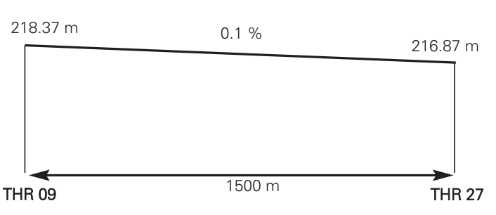
RUNWAY PHYSICAL CHARACTERISTICS
| RWY | Direction | DIM (m) | THR PSN | THR ELEV | SWY (m) | CWY (m) | Strip (m) | OFZ | RESA (m) | RWY/SWY SFC PCN |
|
|---|---|---|---|---|---|---|---|---|---|---|---|
| 09 | 081.22°GEO 086°MAG | 1500 x 30 | 280142.93N 0171319.69W | THR: 218 m / 716 ft TDZ: No |
No | 60 x 150 | 1620 x 80 | No | No | RWY: ASPH
PCN 55/F/B/W/T SWY: No |
|
| 29 | 261.23°GEO 266°MAG | 1500 x 30 | 280150.37N 0171225.42W | THR: 217 m / 712 ft TDZ: No |
No | 60 x 150 | 1620 x 80 | No | No | RWY: ASPH
PCN 55/F/B/W/T SWY: No |
|
| Remarks: None. | |||||||||||
Profile:
DECLARED DISTANCES
| RWY | TORA (m) | TODA (m) | ASDA (m) | LDA (m) |
|---|---|---|---|---|
| 09 | 1500 | 1560 | 1500 | 1500 |
| 27 | 1500 | 1560 | 1500 | 1500 |
| 09 INT A | 400 | 460 | 400 | – |
| 27 INT A | 1100 | 1160 | 1100 | – |
| Remarks: None. | ||||
APPROACH AND RUNWAY LIGHTING
| Runway | 09 | |
| Approach | SLIU. Threshold identification lights. | |
| PAPI (MEHT) | 3° (10.32 m/34 ft). | |
| Threshold | Green. | |
| Touchdown zone | No. | |
| Runway centre line | No. | |
| Runway edge | 1500 m white LIH. Distance between lights: 60 m. | |
| Runway end | Red. | |
| Stopway | No. | |
| Remarks | Guided centre line lights on turn pad. Outside AD HR, switch on of lights by radio (TWR FREQ). Adjustable light intensity. |
| Runway | 27 | |
| Approach | SLIU. Threshold identification lights. | |
| PAPI (MEHT) | 3° (10.34 m/34 ft). | |
| Threshold | Green. | |
| Touchdown zone | No. | |
| Runway centre line | No. | |
| Runway edge | 1500 m white LIH. Distance between lights: 60 m. | |
| Runway end | Red. | |
| Stopway | No. | |
| Remarks | Guided centre line lights on turn pad. Outside AD HR, switch on of lights by radio (TWR FREQ). Adjustable light intensity. |
OTHER LIGHTING, SECONDARY POWER SUPPLY
| ABN/IBN | No. | |
| WDI | 1 near RWY centre LGTD; 1 near THR 09 and 1 near THR 27 NO LGTD. | |
| TWY lighting | Edge. | |
| Apron lighting | Edge, 2 floodlighting poles. | |
| Secondary power supply | Engine generators that provide a maximum switchover (light) time of 15 seconds for all the lighting systems. | |
| Remarks | None. |
HELICOPTER LANDING AREA
| Position | Geoid undulation: see item 2. FATO: RWY 09/27. Coordinates THR 09 and THR 27, see item 12. Ground taxiing: TLOF same as RWY 09/27. Air taxiing: TLOF same as the PRKG 1 and 3. |
|
| Elevation | FATO: RWY 09/27. Elevation THR 09 and THR 27, see item 12.
|
|
| Dimensions, surface, maximum weight, marking | FATO: RWY 09/27. Entry/exit stand signal, stand designation sign, perimeter marking and touchdown zone marking. |
|
| Direction | No. | |
| Declared distances | See item 13. | |
| Lighting | See items 14 and 15. | |
| Remarks | Apron lighting with floodlighting. |
AIR TRAFFIC SERVICES AIRSPACE
Designation |
FIZ LA GOMERA (RMZ) (FPMZ) (1). |
|
Lateral limits |
Intersection of two circles of 3 NM radius centred on THR 09 and THR 27 joined by its common tangent with magnetic heading 078° from THR 09 and 288° from THR 27. |
|
Vertical limits |
SFC-1000 ft AGL -1650 ft AMSL (2). |
|
Airspace class |
G. |
|
Unit Language |
LA GOMERA AFIS. |
|
Transition altitude |
1850 m/6000 ft. |
|
| Hours of applicability | - | |
Remarks |
(1) Flight plan submission mandatory zone within AFIS HR. |
AIR TRAFFIC SERVICES COMMUNICATION FACILITIES
| Service | AFIS | |
| Call sign | La Gomera Información. | |
| FREQ | 118.375 MHz. 121.500 MHz. |
|
| HR | HR AD. HR AD. |
|
| Remarks | EMERG. |
RADIO NAVIGATION AND LANDING AIDS
| Facility (VAR) | ID | FREQ | HR | Coordinates | DME ELEV | Remarks |
|---|---|---|---|---|---|---|
| DVOR (5º W) | LGM | 116.000 MHz | H24 | 280143.5N 0171253.6W | COV 40 NM U/S BTN: - R-288/028 CW; - R-248/288 CW BLW 6000 ft AMSL; - R-218/248 CW BLW 7000 ft AMSL; - R-088/218 CW BLW 6500 ft AMSL; - R-078/088 CW BLW 7000 ft AMSL; - R-068/078 CW BLW 9500 ft AMSL; - R-028/068 CW BLW 12000 ft AMSL. COV 10 NM U/S BTN: - R-310/020 CW, R-065/100 CW & R-135/155 CW BLW 9000 ft AMSL. |
|
| DME | LGM | CH 107X | H24 | 280143.0N 0171253.3W | 210 m | COV 40 NM U/S BTN: - R-288/028 CW; - R-248/288 CW BLW 6000 ft AMSL; - R-218/248 CW BLW 7000 ft AMSL; - R-088/218 CW BLW 6500 ft AMSL; - R-078/088 CW BLW 7000 ft AMSL; - R-068/078 CW BLW 9500 ft AMSL; - R-028/068 CW BLW 12000 ft AMSL. COV 10 NM U/S BTN: - R-310/020 CW BLW 9000 ft AMSL. |
LOCAL AERODROME REGULATIONS
Aerodrome closed to aircraft without radiocommunications.
Control service is not provided at La Gomera airport. See AFIS procedures at ENR 1.5 and AD 1.1.
Microlight operations are not allowed.
Aircraft operating at AFIS aerodromes and in their associated FIZ, shall operate in accordance with a flight plan and shall be equipped for two way radiocommunications.
MINIMUM RUNWAY OCCUPANCY TIME
ARRIVALS
To minimise the runway occupancy time and the possibility of "go-around", pilots are reminded:
- To vacate the runway rapidly and at the highest possible speed without prejudice to safety.
- To vacate the runway completely before halting.
DEPARTURES
Pilots shall be ready for departure when they reach the runway holding position.
TAKE-OFF FROM INTERSECTION
Take-off operations are allowed from RWY 09/27 intersection with TWY A. (See distances at item 13).
Aircraft shall, preferably, request permission at the same time that clearance to start-up.
HANDLING SERVICE TO GENERAL AND BUSINESS AVIATION
All general and business aviation operations require the mandatory provision/hiring of handling services (see Item 4) except:
-All aircraft due to its wingspan (Max 13.54 m), could be parked in the PRKG 4 and 5 of General and Sport Aviation.
At the arrival operations, before unloading, passengers and crew must wait for the arrival of their handling agent.
PERSONNEL MOVEMENT IN APRON
Movements on foot in apron will be always made via marked pedestrian paths, or in a vehicle of authorized handling agent.
OPERATIONAL SAFETY REPORTS
Pilots/operator shall report to the airport as soon as possible about any accidents, incidents, occurrences or events which may have a potential operational impact and in which they have been involved or witnessed.
The aim of these reports is the compilation of the information in order to improve operational safety, independently of the compulsory report of the occurrence to the appropriate aeronautical authority.
Data may be sent in any format, including at least the following information:
- Date and time.
- Site.
- Parties involved (data used to identify vehicles, aircraft…involved).
- Companies implicated.
- Description of the facts.
- Any other data considered relevant (e.g. lighting conditions, weather, phase of the operation such as takeoff / landing / stopover, pavement conditions…).
Contact e-mail address of the airport, for the reception of operational safety reports, is the following:
Seguridad_Operacional_QGZ@aena.es
In addition to notifying the airport by means of the indicated system, it is necessary to send at least basic data of the accident, incident, occurrence or event to the air traffic control service provider (ATC).
NOISE ABATEMENT PROCEDURES
No.
FLIGHT PROCEDURES
LOW VISIBILITY PROCEDURES (LVP)
Low Visibility Procedures (LVP) are not available at La Gomera airport.
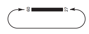
AD TRAFFIC CIRCUIT
ADDITIONAL INFORMATION
Presence of birds (partridges, seagulls, pigeons and others) on runway and overflying. More probably seagulls when raining or with runway wet.
WIND PHENOMENA
Orographic conditions on the island of La Gomera and the airport situation favour the appearance, in determined circumstances, of windshear and turbulence phenomena:
- Occasionally anemometer readings THR 09 and 27 differs from what is detected in short final approach. There is a third anemometer in the middle point which reading is available.
- Intense trade winds may generate turbulence on RWY 27 approach.
- Gentle winds may generate sudden changes in wind direction on RWY 09.
- Hillside gentle winds may generate turbulence in the middle of the runway.
- With W gentle winds may occur that the central anemometer and wind reading are opposite from the one in the operating headway, this causes turbulence and windshear in the runway. In that case the middle point anemometer reading can be useful.
With gentle winds (5 kt-6 kt) can appear the windshear and turbulence phenomena described above.
Likewise, it is recommended that aircraft crew have a basic level of recent experience in the airport.
It is not recommended to approach with directional winds between 300º and 060º (hillside winds) and sustained winds with intensities greater than 15 kt or wind gusts exceeding 20 kt.
AERONAUTICAL CHARTS RELATED TO AN AERODROME
The list of charts related to the aerodrome can be found on the link below:
VISUAL SEGMENT SURFACE (VSS) PENETRATION
Not applicable.