LECU/LEVS AD 2 AERODROME DATA
AERODROME LOCATION INDICATOR AND NAME
LECU/LEVS – MADRID/Cuatro Vientos
AERODROME GEOGRAPHICAL AND ADMINISTRATIVE DATA
| ARP | 402214N 0034707W. See AD 2-LECU/LEVS ADC. | |
| Distance and direction from city | 8.5 km SW. | |
| Elevation | 692 m / 2269 ft. | |
| Geoid undulation | 50.95 m ± 0.05 m (1). | |
| Reference temperature | 33°C. | |
| Low average temperature | 6ºC. | |
| Magnetic variation | 0º (2020). | |
| Annual change | 8.2’E. | |
| AD administration | CIV: Aena. MIL: Ejército del Aire y del Espacio. |
|
| Address | CIV:Aeropuerto de Madrid/Cuatro Vientos; Edificio Terminal;
Ctra. Barrio de la Fortuna, s/n;
28054 Madrid MIL: Base Aérea de Cuatro Vientos; Avenida de la Aviación, 14 -L-10. 28054 - Madrid |
|
| TEL | CIV: +34 913 210 900 (2) MIL: +34-916 493 000 |
|
| FAX | CIV: +34-913 210 949 MIL: +34-916 493 077 |
|
| AFTN | CIV: LECU MIL: LEVSZPZX; LEVSYFYX |
|
CIV:mcvops@aena.es |
||
| Approved traffic | VFR | |
| Remarks | (1) For all AD points. (2) TEL OPS: +34-913 210 922 |
OPERATIONAL HOURS
| Airport | CIV: V: 0700-SS; I: 0800-SS. V: 1100-1200; I: 1200-1300. |
|
| Customs and immigration | HR AD. For flights outside the Schengen Area, a list of passengers and aircrew should be sent 48 hours in advance to the email address mcvops@aena.es | |
| Health and sanitation | No. | |
| OPV | HR AD. | |
| AIS | H24. (2) | |
| ARO | H24 (3). | |
| MET briefing | CIV: HR AD. MIL: HR AD. Other hours depending on the needs of office, MAX 2130 UTC. |
|
| ATS | CIV: HR AD. MIL: HR AD (4) |
|
| Fuelling | HR AD. | |
| Handling | No. | |
| Security | H24. | |
| De-icing | No. | |
| Remarks | (1) Foreign state/military aircraft. See item 20: Local regulations.
(3) Centralised ARO Office Geographical Area 4.
(4) Service provider: Ejército del Aire. |
HANDLING SERVICES AND FACILITIES
| Cargo facilities | No. | |
| Fuel types | CIV: JET A-1, AVGAS 100LL. MIL: JP8 (F34 NATO). |
|
| Oil types | MIL: G-354, G-355, G-359, G-395, H-515, H-537, O-142, O-147, O-155, O-156, S-743, S-749, S-750, S-752, S-1739. | |
| Refuelling capacity | CIV: JET A-1: 1 truck 12500 L, 14.2 L/s. 1 truck 5200 L. AVGAS 100LL: 2 trucks 3000 L |
|
| De-icing facilities | No. | |
| Hangar space | No. | |
| Repair facilities | CIV: For fixed wing aircraft and helicopters. | |
| Remarks | MIL: GPU: AC unit (up to 100 KVA) and DC (up to 2500 A). - Exolum:
|
PASSENGER FACILITIES
| Hotels | MIL: Yes. | |
| Restaurant | Yes. | |
| Transportation | CIV: Taxis, on request. MIL: Buses and light vehicles available on request. |
|
| Medical facilities | CIV: No. MIL: First aid and motor ambulances. |
|
| Bank/Post Office | No. | |
| Tourist information | No. | |
| Remarks | None. |
RESCUE AND FIREFIGHTING SERVICES
| Fire category | CIV: 3. (1) MIL: 5. V: 0530-1300 (MON TO FRI EXC HOL). I: 0630-1400 (MON TO FRI EXC HOL). 4. V: 1300-2030 (MON TO FRI EXC HOL). (2). 0530-2030 (SAT, SUN AND HOL). (2). I: 1400-2130 (MON TO FRI EXC HOL). (2). 0630-2130 (SAT, SUN AND HOL). (2). |
|
| Rescue equipment | In accordance with the fire category published. | |
| Removal of disabled aircraft | CIV: Own equipment available for the removal of disabled aircraft up to 5 Tm. For heavier aircraft, external services are required, subject to
prior presence and/or authorisation by the owner/operator, and at their own expense. Contact details of the coordination centre for the
recovery of disabled aircraft:
MIL: Pulling tractors. |
|
| Remarks | (1) Response time less than 3 MIN, with an operational objective of less than 2 MIN. Category increase requests are not accepted. (2) MIL category extendible to 5 with PPR 48 HR. |
RUNWAY SURFACE CONDITION ASSESSMENT AND REPORTING, AND SNOW PLAN
| Types of clearing equipment | Trucks and pickup trucks with snowplough blade and melter spreader. | |
| Clearance priorities | Helicopter aprons. | |
| Use of material for movement area surface treatment | Urea (UREA). | |
| Specially prepared winter runways | Not applicable. | |
| Remarks | Period of application of snow plan: 1-NOV to 31-MAR. Runway surface condition assessment and reporting in accordance with the Global Reporting Format (GRF) methodology described in AD 1.2.2. Aerodrome in service during all seasons of the year. |
APRONS, TAXIWAYS AND CHECK LOCATIONS/POSITIONS DATA
| Apron | Surface: Concrete. Strength: CIV: Between gates A and B, C and E: PCN 44/R/C/W/T; Between gates B and C: PCN 30/R/C/W/T; East isolated apron: PCN 5/R/C/W/T. West apron: PCN 15/F/D/W/T. |
|
| Taxiways | Width: 15 m. (1) Surface: Asphalt. (1) Strength: A-0 to A-8: PCN 18/F/D/W/T; B-1: PCN 19/R/D/W/T; B-2, K-1, E-2, L-1 and L-2: PCN 15/F/D/W/T; J-3: PCN 18/F/D/W/T. |
|
| Check locations | Altimeter: MIL apron: P1 692 m / 2270 ft. P2 691 m / 2266 ft. P2 684 m / 2243 ft. CIV apron: 687 m / 2255 ft. East isolated apron: 687 m / 2254 ft. West apron: 687 m / 2255 ft. VOR: No. INS: No. |
|
| Remarks | (1) Except C-1 and J-1 air taxi-routes for helicopters; and T-1 Natural soil. |
SURFACE MOVEMENT GUIDANCE AND CONTROL SYSTEM AND MARKINGS
| Taxiing guidance system | Boards, NO ENTRY signs, runway-holding positions and intermediate holding positions on exit taxiways. | |
| RWY markings | Designators, threshold, centre line, side stripe, aiming point, touchdown zone, and rapid exit taxiway markings on RWY 27 (J3). | |
| TWY markings | Centre line and edge. C-1 and J-1: Centre line. | |
| Remarks | None. |
AERODROME OBSTACLES
| Obstacles which penetrate Approach, Take-off climb, Conical, Inner Horizontal and Transitional Surfaces contained in Annex 14 of ICAO; and areas 2A and 3 contained in Annex 15 of ICAO: | See Item 10 and Data Set. | |
| Remarks | See AD 2-LECU/LEVS AOC. |
METEOROLOGICAL INFORMATION PROVIDED
| MET office | CIV: Madrid/Cuatro Vientos OMD. MIL: Cuatro Vientos OMD. |
|
| HR | CIV: HR AD. Outside this schedule, a half-hourly METAR AUTO will be issued. MIL: HR AD. Other hours depending on the needs of office, MAX 2130 UTC. |
|
| METAR | Half-hourly. | |
| TAF | 24 HR. | |
| TREND | No. | |
| Briefing | CIV: Telephone, email and AMA. MIL: In person and all the other means. |
|
| Flight documentation/Language | Charts and plain language / Spanish. | |
| Charts | Significant forecasted and wind and temperature in altitude maps. | |
| Supplementary equipment | CIV: AMA. MIL: Clouds and lightnings image and radar information display. |
|
| ATS unit served | TWR. | |
| Additional information | Madrid OMAe (LEMC): H24
MADRID/Cuatro Vientos MET office: |
|
| Remarks | Aerodrome climatological summary available. Aerodrome warnings available. Automatic reports do not include precipitation information. |
RUNWAY PHYSICAL CHARACTERISTICS
| RWY | Direction | DIM (m) | THR PSN | TDZ ELEV | SWY (m) | CWY (m) | Strip (m) | OFZ | RESA (m) | RWY/SWY SFC PCN |
|---|---|---|---|---|---|---|---|---|---|---|
| 09 | 093.78° GEO 094° MAG |
1500 x 30 | 402216.04N 0034738.14W | THR: 692 m / 2269 ft TDZ: No |
54 x 30 | No | 1740 x 80 | No | No | RWY: ASPH PCN 39/F/A/W/T (2) SWY: INFO NO AVBL |
| 27 | 273.79° GEO 274° MAG |
1500 x 30 | 402212.84N 0034634.87W | THR: 686 m / 2250 ft TDZ: No |
55 x 30 | No | 1740 x 80 | No | No | RWY: ASPH PCN 39/F/A/W/T (2) SWY: INFO NO AVBL |
| 09 (1) | 094.10° GEO 095° MAG |
1127 x 45 | 402220.43N 0034726.54W | THR: 690 m / 2264 ft TDZ: No |
No | No | No | No | No | Natural soil |
| 27 (1) | 274.11° GEO 275° MAG |
1127 x 45 | 402217.84N 0034639.32W | THR: 684 m / 2244 ft TDZ: No |
No | No | No | No | No | Natural soil |
Remarks: (1) Closed to civil traffic. (2) EXC between L-1 and K-1: PCN 74/F/C/W/T. |
||||||||||
Profile:
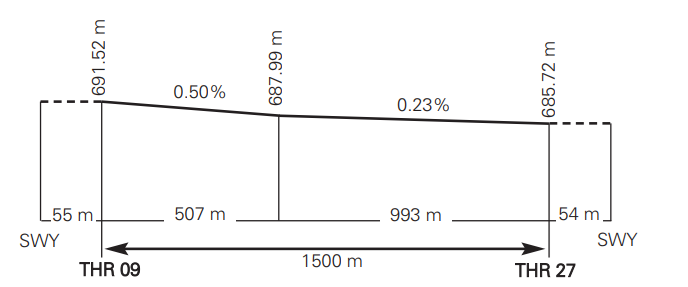
DECLARED DISTANCES
| RWY | TORA (m) | TODA (m) | ASDA (m) | LDA (m) |
|---|---|---|---|---|
| 09 | 1500 | 1500 | 1554 | 1500 |
| 27 | 1500 | 1500 | 1555 | 1500 |
| 09 INT K-1 | 1278 | 1278 | 1332 | – |
| Remarks | None. | |||
APPROACH AND RUNWAY LIGHTING
| Runway | 09 | |
| Approach | Simple, 420 m. | |
| PAPI (MEHT) | 2.8° (8.20 m / 27 ft). | |
| Threshold | Green. | |
| Touchdown zone | No. | |
| Runway centre line | No. | |
| Runway edge | 1500 m: 900 m white + 600 m yellow. (1) Distance between lights: 50 m. | |
| Runway end | Red. | |
| Stopway | No. | |
| Remarks | (1) Adjustable lights intensity. Lights are switched on by request to ATC Service during operational hours. |
| Runway | 27 | |
| Approach | Simple, 300 m. | |
| PAPI (MEHT) | 3° (9.00 m / 30 ft). | |
| Threshold | Green. | |
| Touchdown zone | No. | |
| Runway centre line | No. | |
| Runway edge | 1500 m: 900 m white + 600 m yellow. (1) Distance between lights: 50 m. | |
| Runway end | Red. | |
| Stopway | No. | |
| Remarks | (1) Adjustable lights intensity. Lights are switched on by request to ATC Service during operational hours. |
OTHER LIGHTING, SECONDARY POWER SUPPLY
| ABN | 1 near AD. | |
| WDI | 1 near THR 09, 1 near THR 27. LGTD. | |
| TWY lighting | Edge. C-1 and J-1: Centre line (reflective markers). | |
| Apron lighting | CIV: 6 lighting towers. East isolated apron: 2 lighting towers. |
|
| Secondary power supply | Engine generators, 3 s start-up and a maximum switch-over time of 14 s. | |
| Remarks | None. |
HELICOPTER LANDING AREA
| Position | CIV: FATO RWY 09/27. See item 12. MIL: To the north of ARP. |
|
| Elevation | CIV: See item 12. MIL: H-1: 686 m / 2251 ft; H-2: 685 m / 2249 ft. |
|
| Dimensions, surface, maximum weight, marking | CIV: FATO: See items 8, 9 and 12. Air taxiing: TWY C-1: CBR 50 and J-1: CBR 52. See taxiing routes in item 20. Stands: See PDC. CIV: Simultaneous operations are not allowed for helicopters on the contiguous stands. In PRKG TLO-05 and 80, aircraft must be towed to and from the stands if PRKG 07 and 81 are occupied. MIL: H-1 Helisurface: 30 m x 40 m, base concrete - surface asphalt. H-2 Helisurface: 18 m x 18 m / Natural soil. TWY O-1: 10 m x 142 m / Asphalt. |
|
| Direction | CIV: See item 12. MIL: 09/27. |
|
| Declared distances | CIV: See table below (*). MIL: No. |
|
| Lighting | CIV: See items 14 and 15. MIL: Edge and approach lighting system at H-1. |
|
| Remarks | MIL: Use forbidden to civil aircraft. VASIS at H-1. |
(*)
| RWY | TORA (m) | TODA (m) | ASDA (m) | LDA (m) |
|---|---|---|---|---|
| 09 INT C-1 | 124 | 124 | 178 | – |
| 09 INT J-1 | 269 | 269 | 323 | – |
| 09 INT K-1 | 1278 | 1278 | 1332 | – |
| 27 INT C-1 | 1373 | 1373 | 1428 | – |
| 27 INT J-1 | 1227 | 1227 | 1282 | – |
| 27 INT K-1 | 234 | 234 | 289 | – |
AIR TRAFFIC SERVICES AIRSPACE
| Designation | ATZ MADRID/CUATRO VIENTOS. | |
| Lateral limits | Circle radius 3 km centred on ARP. | |
| Vertical limits | SFC-4500 ft AMSL. | |
| Airspace class | D. | |
| Unit / Language | CUATRO VIENTOS TWR. ES/EN. |
|
| Transition altitude | 3962 m/13000 ft. | |
| Hours of applicability | - | |
| Remarks | None. |
AIR TRAFFIC SERVICES COMMUNICATION FACILITIES
| Service | Call sign | FREQ | HR | Remarks |
|---|---|---|---|---|
| TWR | Cuatro Vientos TWR | 118.705 C | HR AD | - |
| 121.500 MHz | H24 | EMERG | ||
| 121.805 C | HR AD | GMC | ||
| 137.525 MHz | HR AD | MIL | ||
| 139.300 MHz | HR AD | MIL | ||
| 257.800 MHz | HR AD | MIL | ||
| 122.505 C | HR AD | BACK UP | ||
| ATIS | Cuatro Vientos Information | 118.230 C | HR AD | |
| D-ATIS | Cuatro Vientos Information | NIL | HR AD | Provision of ATIS information via data link. |
| VDF | Cuatro Vientos Gonio | 118.705 C | HR AD | - |
| 121.500 MHz | HR AD | - | ||
| 137.525 MHz | HR AD | - | ||
| 121.805 C | HR AD | - |
RADIO NAVIGATION AND LANDING AIDS
| Facility (VAR) | ID | FREQ | HR | Coordinates | ELEV DME | Remarks |
|---|---|---|---|---|---|---|
| NDB (0°) | CVT | 417.000 kHz | H24 | 402204.0N 0034624.2W | - | COV 10 NM AVBL at 5000 ft AMSL. |
LOCAL AERODROME REGULATIONS
AD available only for light civil aircraft, military and State aircraft under VFR.
Medium wake civil aircraft with prior application and subsequent clearance
from local ATC and airport Management, also for VFR flights. With the
following speed restrictions for arrivals and departures by the visual points and
circuit manoeuvres:
| Light civil aircraft | Medium wake civil aircraft | |
|---|---|---|
| Aircraft type | All | All |
| IAS MAX | 150 kt | 150 kt |
AD closed to aircraft without two-way radio communication.
Starting up engines before the start of operational hours is not permitted.
Unavailability of PEV: traveller entry point for pets from third countries.
APRON SATURATION
Should there be no stands available on the apron, it will be permitted to park in the zones designated on the PDC as "saturation parking area" and "east isolated apron". To access these, the engines must be stopped at the “stop engine” point, and the aircraft parked by towing. Exit shall be performed by towing the aircraft up to the start of the taxiway centre line marking, and at this point start-up of the engines shall take place.
The maximum aircraft allowed for the “East isolated apron” is maximum wingspan 18 m.The maximum aircraft allowed for the “Saturation parking area” is maximum wingspan 12 m and maximum length 11 m.
FOREIGN STATE/MILITARY STATE AIRCRAFT
PPR request is mandatory at least 72 hours in advance. When transporting dangerous goods, the request will be accomplished at least 2 working days in advance.
PPR request will be submitted during HR AD to the AFTN addresses LEVSZPZX and LEVSYFYX and to the e-mail address: poc_ba_cuatro_vientos@ea.mde.es
START-UP PROCEDURE
ATC shall consider that every aircraft at the holding position is able to commence the line up on the runway and the take-off run immediately after the appropriate clearance is issued and in a maximum time of five minutes.
Aircraft unable to comply with this requirement shall notify ATC before reaching the holding position.
TAXIING RESTRICTIONS
On the apron TWY for accessing the stands, aircraft with wingspan greater than 18 m must follow ATC instructions.
When vacating runway, hold position at intermediate holding positions and await ATC instructions.
CIVIL APRON
PRKG 07 is reserved for hospital and emergency flights and, in the case of not being used by this kind of flights, may be used by aircraft for boarding/unboarding passengers during a period less than 3 hours and following request to operations office.
WEST APRON
Reserved for restricted use of hangars. The maximum aircraft allowed is maximum wingspan 18 m.
MILITARY APRONS
Due to the characteristics of the taxiing guidance system to the parking positions in the military aprons, operations in this area of aircraft with wing span greater than 20 m or length greater than 16 m, must be executed with extreme caution. Aircraft will wait at the entry of the military apron designated by TWR for the arrival of a "FOLLOW ME" vehicle or signalman in order to be guided to the stand designated for its parking.
AIRCRAFT ANCHORAGE
Anchoring in all parking positions is made available to users. Should adverse weather conditions are forecasted, the aircraft anchorage with MTOW less than 5700 Kg shall proceed the anchorage.
HANGAR USE
Aircraft using a hangar and with no monthly parking ticket in LECU, shall contact the operations Office upon arrival and prior to departure thereof.
STANDARD TAXIING ROUTES
RWY 27 CONFIGURATION
a) Departures.
PRKG 00 to 27: Taxiing via gate D, TWY A-4, A-3 to the runway-holding position.
PRKG 28/29, 30/31, 32/33, 34 and 35:
• Fixed-wing aircraft taxiing via gate C, TWY A3 to the runway-holding position.
• Helicopters taxiing via gate C, TWY C-1.
PRKG 36-82 and saturation parking area: Taxiing via gate B to the runway-holding position.
East isolated apron: Taxiing via TWY A-0, A-1, A-2 to the runway-holding position or TWY C-1 following TWR instructions.
West apron:
• Fixed-wing aircraft taxiing vía TWY A-6, A-5, A-4, A-3 to the runway-holding position.
• Helicopters taxiing vía TWY A-6, A-7 to the runway-holding position K-1.
Operational aircraft: Exempt from complying with standard routes. These will contact the control service and follow ATC instructions.
Helicopters departing via gate E will use TWY J-1 following ATC instructions.
b) Arrivals.
PRKG 00-82 and saturation parking area: Aircraft will taxi around TWY A and enter the apron through gate E or that designated by the TWR.
East isolated apron: Taxiing via TWY A up to the apron.
Helicopters:
• For the West Apron (Hangars 4 to 11), aircraft shall exit the runway normally via TWY K-1 unless otherwise instructed by ATC, and taxi via TWY A
to the West Apron.
Operational aircraft: exempt from complying with standard routes. These will contact the control service and follow ATC instructions.
All standard routes are subject to modification by the ATS unit.
RWY 09 CONFIGURATION
a) Departures.
PRKG 00 to 27: Taxiing via gate D, A-5, A-6, A-7, A-8 to the runway-holding position.
PRKG 28/29, 30/31, 32/33, 34 and 35:
• Fixed-wing aircraft taxiing via gate C, TWY A-4, A-5, A-6, A-7, A-8 to the runway-holding position.
• Helicopters taxiing via gate C, TWY C-1.
PRKG 36-82 and saturation parking area: Taxiing via gate B, A-3, A-4, A-5, A-6, A-7, A-8 to the runway-holding position.
East isolated apron: Taxiing via A-0, A-1, A-2, A-3, A-4, A-5, A-6, A-7, A-8 to the runway-holding position.
West apron:
• Fixed-wing aircraft taxiing vía TWY A-6, A-5, A-4, A-3 to the runway-holding position.
• Helicopters taxiing vía TWY A-6, A-7 to the runway-holding position K-1.
Operational aircraft: exempt from complying with standard routes. These will contact the control service and follow ATC instructions.
Helicopters departing via gate E will use TWY J-1 following ATC instructions.
b) Arrivals.
PRKG 00-82 and saturation parking area: Aircraft will taxi around TWY A and enter the apron through gate E.
East isolated apron: Taxiing via TWY A up to the apron.
Helicopters:
• For the West Apron (Hangars 4 to 11), aircraft shall exit the runway normally via TWY K-1 unless otherwise instructed by ATC, and taxi via TWY A
to the West Apron.
Operational aircraft: exempt from complying with standard routes. These will contact the control service and follow ATC instructions.
All standard routes are subject to modification by the ATS unit.
ENERGY SAVINGS POLICY, TURN AERONAUTICAL SURFACE LIGHTS OFF
During operating hours, and should there are no adverse weather conditions or turn-on request, energy savings procedures are applied consisting of the turning-off of all or some of the surface aeronautical lights indicated in item 14 of AD 2-LECU/LEVS.
ENGINE TEST
ATC clearance must be requested prior to beginning an engine test.
MINIMUM RWY OCCUPANCY TIME
Notwithstanding aircraft safety and standard operations, pilots are reminded that rapid exit from the RWY enables maximum runway utilisation and reduces its occupancy time.
Unless otherwise indicated by ATC, aircraft shall vacate RWY 27 via rapid exit taxiway J3.
FLIGHTS FROM LECM TO LECU (FLIGHTS Y)
| ATS ROUTES | CONTROL TRANSFER POINT | COMMUNICATION TRANSFER |
|---|---|---|
| Traffic from East | Circuit or vertical from aerodrome at 4000 ft QNH | 10 NM before aerodrome |
| Traffic from West/Southwest | Point S passing at 4000 ft QNH | 10 NM before point S |
| Traffic from West/Northwest | Point N passing at 4000 ft QNH | 10 NM before point N |
Any other procedure must be previously coordinated.
FLIGHTS FROM LECU TO LECM (FLIGHTS Z WITH FIRST IFR POINT CVT)
| ATS ROUTES | CONTROL TRANSFER POINT |
|---|---|
| Circuit or vertical from aerodrome leaving at 4000 ft in climb at 5000 ft QNH |
Any other procedure must be previously coordinated.
OPERATIONAL SAFETY REPORTS
Pilots/operator shall report to the airport as soon as possible about any accidents, incidents, occurrences or events which may have a potential operational impact and in which they have been involved or witnessed.
The aim of these reports is the compilation of information in order to improve operational safety, independently from the compulsory report of the occurrence to the appropriate aeronautical authority. Data may be sent in any format, including at least the following information:
- Date and time.
- Site.
- Parties involved (data used to identify vehicles, aircraft...involved).
- Companies involved.
- Description of the facts.
- Any other data considered relevant (e.g. lighting conditions, weather, phase of the operation such as take-off / landing / stopover, pavement conditions…).
The airport's contact e-mail address, for the reception of operational safety
reports, is the following:
Seguridad_Operacional_MCV@aena.es
In addition to notifying the airport by means of the indicated system, it is necessary to send at least basic data of the accident, incident, occurrence or event to the air traffic control service provider (ATC).
NOISE ABATEMENT PROCEDURES
No.
FLIGHT PROCEDURES
Aircraft taking-off from RWY 09 shall leave the aerodrome traffic circuit after finishing the right tail wind leg and ask for clearance to control tower to cross the approach area of RWY 09.
Helicopters taking-off from AD MIL, Helisurface 09 (Apron H-1), shall leave the military aerodrome traffic circuit after finishing the left tail wind leg on course to point N (Boadilla del Monte).
The helicopter landing area of Hospital Central de la Defensa (Gómez-Ulla) is marked with automatic marking lights, FREQ 136.000 MHz, with a response time in seconds.
ATS SURVEILLANCE SYSTEM
ATS surveillance systems may be used in the aerodrome control service to carry out the following duties:
a) Supervision of the flight path of aircraft on final approach;
b) Supervision of the flight paths of other aircraft in the vicinity of the aerodrome.
Depending on the availability of the radars which provide coverage to the ATZ, the areas or heights for which the indicated uses of the radar are supplied could be affected. The air traffic controllers at the aerodrome shall maintain all the operations performed at it or in its vicinity under constant visual surveillance, with access to an ATS surveillance system to support that visual observation, as stipulated in article 4.5.1.3 of the Reglamento de la Circulación Aérea. All of the foregoing shall depend on the limitations of the equipment
LOW VISIBILITY PROCEDURES (LVP)
Low Visibility Procedures (LVP) are not available at Madrid/Cuatro Vientos airport.
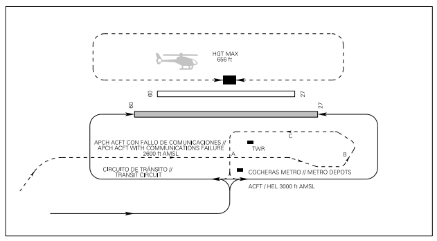
COMMUNICATIONS FAILURE PROCEDURE
After joining the communications failure circuit (from the point S, Residencial Miraflores, AD 2-LECU/LEVS VAC) at 2600 ft AMSL, one segment should be performed parallel to the runway (Segment A), equidistant between TWR and the Metro depots situated to the South. After this, they shall perform a turn (Turn B) and another segment (Segment C) passing in front of TWR to receive the light signals, overflying the taxiway and avoiding passing over the hangars and the apron. Finally, one segment perpendicular to the runway is performed to join the AD traffic circuit in the corresponding direction and at 3000 ft AMSL.
AD TRAFFIC CIRCUIT
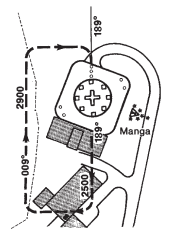
Helicopter circuit of the Gómez-Ulla military hospital.
ARRIVALS: Helicopters arriving at this heliport must establish radio contact with Madrid/Cuatro Vientos TWR 5 minutes before the estimated time of arrival, notifying their position and intentions, with the object of receiving information on main traffic.
DEPARTURES: Helicopters prepare to take-off from this heliport must establish radio contact with Madrid/Cuatro Vientos TWR before taking-off, notifying the route to be followed after take-off, in order to receive instructions.
ADDITIONAL INFORMATION
Caution due to standing water on runway and taxiway under moderate rain conditions.
BIRDS AREAS OF CONCENTRATION AND FLOWS
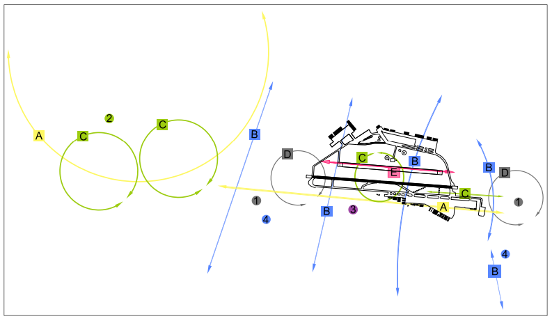
- A. White stork.
- B. Wood pigeon, common pigeon.
- C. Black kite, black vulture, booted eagle.
- D. Common swift, swallow.
- E. Laughing gull, lesser black-backed gull.
- Area 1.- Starling and swift concentration.
- Area 2.- Bird of prey concentration.
- Area 3.- Partridge and little bustard concentration.
- Area 4.- Pigeon concentration.
- Movement A: Sporadic displacements of white storks in Spring and Summer to the South of the runway and around THR 09.
- Movement B: Displacements of pigeons can be seen all year, mainly moving North-South. More abundant close to the two thresholds.
- Movement C: Displacements of birds of prey, principally black kites and black vultures. They are more abundant in Spring and Summer and in the vicinity of Venta la Rubia. In Winter, presence of common buzzards and red kites. Within the airport, specimens in search of carrion or using thermals to climb.
- Movement D: Displacements of insectivorous birds such as swifts, swallows and starlings. Very numerous in Summer on feeding flights, especially around the two thresholds.
- Movement E: Displacements of gulls, but only present in Autumn and Winter. When there is fog, rain or wind, they perch inside the airport early in the morning.
AERONAUTICAL CHARTS RELATED TO THE AERODROME
The list of charts related to the aerodrome can be found on the link below:
VISUAL SEGMENT SURFACE (VSS) PENETRATION
Not applicable.