LERJ AD 2 AERODROME DATA
AERODROME LOCATION INDICATOR AND NAME
LERJ - LOGROÑO
AERODROME GEOGRAPHICAL AND ADMINISTRATIVE DATA
| ARP | 422738N 0021914W. See AD 2-LERJ ADC. | |
| Distance and direction from the city | 10 km E. | |
| Elevation | 352 m / 1156 ft. | |
| Geoid undulation | 51 m ± 0.05 m (1). | |
| Reference temperature | 30°C. | |
| Magnetic variation | 0º (2020). | |
| Annual change | 8.3’E. | |
| AD administration | Aena. | |
| Address | Aeropuerto de Logroño-Agoncillo Crta N232 (Logroño-Zaragoza) s/n 26160 Agoncillo (La Rioja). |
|
| TEL | +34-941 277 400/477 | |
| FAX | +34-941 277 410/479 | |
| AFTN | LERJ | |
| operacioneslarioja@aena.es | ||
| Approved traffic | IFR/VFR. | |
| Remarks | (1) For all AD points. |
OPERATIONAL HOURS
| Airport | From the second-last Saturday in July to the first Sunday in September, both inclusive.
V: MON-FRI 0630-1700 SAT 0630-1030 SUN 1200-1600
V: SAT 1030-1730 SUN 0830-1100 and 1600-1830
V: MON-FRI 0525-1100 and 1635-2000 PS 30-MIN PPR 30 MIN BFR AD CLSD SAT 0630-1030 SUN 1600-1930 PS 1 HR PPR 30 MIN BFR AD CLSD I: MON-FRI 0625-1200 and 1735-2100 PS 30 MIN PPR 30 MIN BFR AD CLSD SAT 0730-1130 SUN 1700-2030 PS 1 HR PPR 30 MIN BFR AD CLSD
V: MON-FRI 1100-1635 SAT 1030-1730 SUN 0830-1315 and 1415-1600 I: MON-FRI 1200-1735 SAT 1130-1830 SUN 0930-1415 and 1515-1700 |
|
| Customs and Immigration | Yes (4). | |
| Health and Sanitation | No. | |
| AIS/ARO | H24 (5) | |
| MET briefing | HR AD. | |
| ATS |
V: MON-FRI 0615-1720
V: MON-FRI 0510-2020 PS 30MIN PPR BFR AD CLSD |
|
| Fuelling | HR AD, public and restricted use. PPR, to:
|
|
| Handling | HR AD, public use. | |
| Security | HR AD, public and restricted use. | |
| De-icing | HR AD, public use. | |
| Remarks | Airport hours of activity: See HR ATS. In case of expediting PPR, see (6). (1) Possibility for authorisation of commercial flights outside AD operational schedule, public use, subject
to request at least 48 hours in advance and with prior authorisation. See item 20 “Local regulations”,
Commercial operations outside AD schedule, public use. (4) Requests at least 48 HR in advance to operacioneslarioja@aena.es (5) Centralised ARO office geographical area 2.
Centralised AIO Office - International NOTAM Office
(6) V: MON-FRI 0510-2050 SUN 0815-1335 and 1400-2050 I: MON-FRI 0610-2150 SUN 0915-1435 and 1500-2150 |
HANDLING SERVICES AND FACILITIES
| Cargo facilities | Cargo terminal 260 m2. | |
| Fuel types | JET A-1, AVGAS 100LL. (1). | |
| Oil types | No. | |
| Refuelling capacity | JET A-1: 140000 l, 20 L/s. AVGAS 100LL: 20000 l, 1.5 L/s. |
|
| De-icing facilities | Yes; PRKG 4. | |
| Hangar space | No. | |
| Repair facilities | No. | |
| Remarks | (1) PPR CTC.
Hiring a handling agent is mandatory for General Aviation operations whose MTOW is higher than 10 TM or that involve the transport more of four passengers. Ramp agents: - SOUTH EUROPE GROUND SERVICES
|
PASSENGER FACILITIES
| Hotels | No. | |
| Restaurant | No. | |
| Transportation | Taxies and buses. | |
| Medical facilities | No. | |
| Bank/Post Office | No. | |
| Tourist information | No. | |
| Remarks | None. |
RESCUE AND FIREFIGHTING SERVICES
| Fire category | 5. HR AD, public use. (1) (2) HR AD, restricted use: non-private means of restricted use. (3) |
|
| Rescue equipment | In accordance with the fire category published. | |
| Removal of disabled aircraft | The Airport possesses the following equipment for removing disabled aircraft:
|
|
| Remarks | (1) CAT 6 and 7 on request, according to the procedure (see item 20, Local regulations: procedure for the
request of rescue and fire fighting level of protection on demand). (2) The end-area response time of RWY 11/29 is less than 3 MIN, with an operational target of less than 2 MIN (3) Means of extinction: 1 firefighter team leader and 2 firefighters with, 2 vehicles with foam-making equipment holding 6100 L water for the production of foam meeting performance level C (ICAO), capable of discharging foam solution at a rate of 5000 L/min, complementary agent of 250 kg of BC powder or 90 of CO2. |
RUNWAY SURFACE CONDITION ASSESSMENT AND REPORTING, AND SNOW PLAN
| Types of clearing equipment | Urea spreader, snowplough. | |
| Clearance priorities | Runway, TWY A and aprons. | |
| Use of material for movement area surface treatment | Urea (UREA). | |
| Specially prepared winter runways | Not applicable. | |
| Remarks | Period of application of snow plan: 1-NOV to 30-MAR. Runway surface condition assessment and reporting in accordance with the Global Reporting Format (GRF) methodology described in AD 1.2.2. Aerodrome in service during all seasons of the year. |
APRONS, TAXIWAYS AND CHECK LOCATIONS/POSITIONS DATA
| Apron | Surface: Concrete. Strength: PCN 27/R/A/W/T. |
|
| CC.AA. Base apron | Surface: Concrete. Strength: PCN 49/R/A/W/T. |
|
| General aviation apron | Surface: Concrete. Strength: PCN 15/F/D/W/T. |
|
| Taxiways | Width: A: 23 m, B: 15 m, D: 8.5 m. |
|
| Check locations | Altimeter: Apron ELEV 349 m/1145 ft. |
|
| Remarks | None. |
SURFACE MOVEMENT GUIDANCE AND CONTROL SYSTEM AND MARKINGS
| Taxiing guidance system | Runway holding position, stop bar (1), boards and stand markings. | |
| RWY markings | Designators, threshold, centre line, touchdown zone, side stripe and aiming point. | |
| TWY markings | Centre line, side stripe. | |
| Remarks | Retroreflective markers at edge of TWY D, apron, general aviation apron and runway turn pads. (1) LED lighting. |
AERODROME OBSTACLES
| Obstacles in Approach, Take-Off Climb, Conical, Inner Horizontal, Transitional, Inner Transitional and Balked Landing Surfaces established in ICAO Annex 14; and the areas 2A and 3 established in ICAO Annex 15. Those penetrating these surfaces are identified in the CSV file as “Relevante_Relevant = Si/Yes”. | See Item 10 and Data Set. | |
| Remarks | See AD 2-LERJ AOC. |
METEOROLOGICAL INFORMATION PROVIDED
| MET office | (1). | |
| HR | (1). | |
| METAR | (1). | |
| TAF | (1). | |
| TREND | (1). | |
| Briefing | (1). | |
| Flight documentation/Language | (1). | |
| Charts | (1). | |
| Supplementary equipment | (1). | |
| ATS unit served | (1). | |
| Additional information | (1). | |
| Remarks | (1) MET office is located at the Military Base and provides its information with the LELO indicator. (See AD 3-LELO item 11). |
RUNWAY PHYSICAL CHARACTERISTICS
| RWY | Direction | DIM (m) | THR PSN | THR ELEV / TDZ ELEV | SWY (m) | CWY (m) | Strip (m) | OFZ | RESA (m) | RWY/SWY SFC PCN |
|---|---|---|---|---|---|---|---|---|---|---|
| 11 | 109.78° GEO 110° MAG |
2200 x 45 | 422749.43N 0021956.99W | THR: 352 m / 1156 ft TDZ: No |
No | 60 x 150 | 2320 x 280 (1) | No | 90 x 90 | RWY: ASPH PCN 73/F/B/W/T (2) (3) SWY: No |
| 29 | 289.80° GEO 290° MAG |
2200 x 45 | 422725.29N 0021826.36W | THR: 347.1 m / 1138 ft TDZ: 349.8 m / 1147 ft |
No | 60 x 150 | 2320 x 280 (1) | No | 90 x 90 | RWY: ASPH PCN 73/F/B/W/T (2) (4) SWY: No |
| Remarks: (1) Unpaved. |
||||||||||
Profile
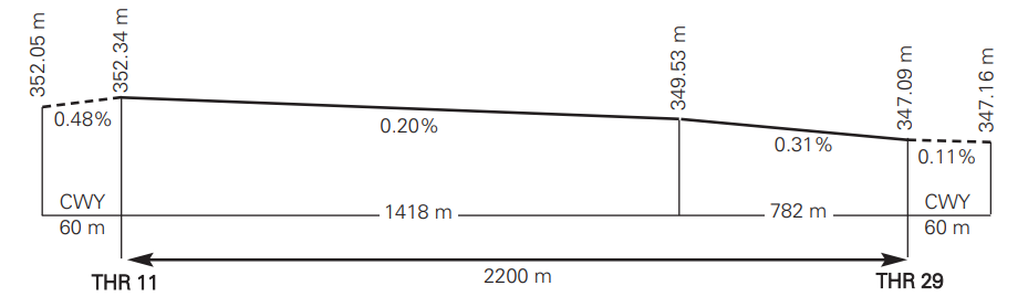
DECLARED DISTANCES
| RWY | TORA (m) | TODA (m) | ASDA (m) | LDA (m) |
|---|---|---|---|---|
| 11 | 2200 | 2260 | 2200 | 2200 |
| 29 | 2200 | 2260 | 2200 | 2200 |
| 29 INT A | 1669 | 1729 | 1669 | – |
| 11 INT B | 875 | 935 | 875 | – |
| 29 INT B | 1341 | 1401 | 1341 | – |
| Remarks | None. | |||
APPROACH AND RUNWAY LIGHTING
| Runway | 11 | |
| Approach | No. | |
| PAPI (MEHT) | 2.97° (16.10 m/53 ft). | |
| Threshold | Green, with wing bar. | |
| Touchdown zone | No. | |
| Runway centre line | 2201 m: 1301 m white+600 m red and white+300 m red (1). Distance between lights: 30 m. | |
| Runway edge | 2201 m: 1601 m white + 600 m yellow. (1) Distance between lights: 60 m. | |
| Runway end | Red. | |
| Stopway | No. | |
| Remarks | (1) Adjustable light intensity. |
| Runway | 29 | |
| Approach | Precision CAT I, 900 m. (1). | |
| PAPI (MEHT) | 2.99° (15.18 m/50 ft). | |
| Threshold | Green, with wing bar. | |
| Touchdown zone | No. | |
| Runway centre line | 2201 m: 1301 m white+600 m red and white+300 m red (1). Distance between lights: 30 m. | |
| Runway edge | 2201 m: 1601 m white + 600 m yellow. (1) Distance between lights: 60 m. | |
| Runway end | Red. | |
| Stopway | No. | |
| Remarks | (1) Adjustable light intensity. |
OTHER LIGHTING, SECONDARY POWER SUPPLY
| ABN/IBN | No. | |
| WDI | 1 near THR 11, 1 near THR 29. LGTD. | |
| TWY lighting | A: Centre line and edge (1); B: Edge (1), to the runway holding position; D: No. | |
| Apron lighting | Floodlighting poles. Apron General Aviation: No. |
|
| Secondary power supply | Engine generators that provide a maximum switch over (light) time of 15 seconds. Switch over for emergency systems (runway edge, THR 29 and 11, RWY end 29 and 11, stop bar, approach system, PAPI 29 and 11) less than 1 seconds. | |
| Remarks | Runway turn pads edge (1). (1) LED lighting. |
HELICOPTER LANDING AREA
| Position | Geoid undulation: See item 2. FATO: RWY 11/29. Coordinates THR 11 and THR 29, see item 12. Ground taxiing: TLOF same as RWY 11/29. Coordinates 422738N 0021914W (same as ARP). Air Taxiing: TLOF same as the PRKG 1H, 4H and 5H. |
|
| Elevation | FATO: RWY 11/29. Elevation THR 11 and THR 29, see item 12. Ground taxiing: TLOF same as RWY 11/29. Elevation 352 m (Same as ARP). Air Taxiing: TLOF same as the PRKG 1H, 4H and 5H. |
|
| Dimensions, surface, maximum weight, marking | FATO: RWY 11/29, see item 12. Ground taxiing: TLOF same as RWY 11/29, see item 12. Air Taxiing: PRKG 1H, 4H and 5H: Concrete PCN 27/R/A/W/T. As it coincides with the stands, it does not require TLOF marking. |
|
| Direction | No. | |
| Declared distances | Check table below. (*) | |
| Lighting | No. | |
| Remarks | None. |
(*)
| RWY | RTODAH (m) | TODAH (m) | LDAH (m) |
|---|---|---|---|
| 11 INT A | 554 | 614 | 1669 |
| 29 INT A | 1669 | 1729 | 554 |
| 11 INT B | 875 | 935 | 1341 |
| 29 INT B | 1341 | 1401 | 875 |
AIR TRAFFIC SERVICES AIRSPACE
Designation |
CTR LOGROÑO. |
|
Lateral limits |
423339N 0023308W; 423339N 0023055W; 423053N 0022537W; arc centred on DVOR/DME LPA: 422738N 0021937W, radius 5.5 NM, clockwise; 423208N 0021519W; 423200N 0020554W; 422511N 0020347W; 422215N 0020505W; 422208N 0021932W; arc centred on DVOR/DME LPA: 422738N 0021937W, radius 5.5 NM, clockwise; 422539N 0022633W; 422556N 0023521W; 422845N 0023539W; 423339N 0023308W. |
|
Vertical limits |
SFC-1000 ft AGL. |
|
Airspace class |
D. |
|
Unit Language |
RIOJA TWR. ES/EN. |
|
Transition altitude |
1850 m/6000 ft. |
|
Hours of applicability |
- |
|
Remarks |
None. |
Designation |
ATZ LOGROÑO. |
|
Lateral limits |
Circle radius 8 km centred on DVOR/DME LPA (1). |
|
Vertical limits |
SFC-3000 ft HGT (2). |
|
Airspace class |
D. |
|
Unit Language |
RIOJA TWR. ES/EN. |
|
Transition altitude |
- |
|
Hours of applicability |
- |
|
Remarks |
(1) Or the ground visibility, whichever is lower. |
AIR TRAFFIC SERVICES COMMUNICATION FACILITIES
| Service | Call sign | FREQ | HR | Remarks |
|---|---|---|---|---|
| APP/TWR | Rioja TWR | 118.580 C | HR ATS | APP/L |
| 121.500 MHz | HR ATS | EMERG | ||
| 243.000 MHz | HR ATS | EMERG | ||
| 121.705 C | HR ATS | GMC |
RADIO NAVIGATION AND LANDING AIDS
| Facility (VAR) | ID | FREQ/CH | HR | Coordinates | DME ELEV | Remarks |
|---|---|---|---|---|---|---|
| DVOR (0º) | LPA | 115.450 MHz | H24 | 422737.9N 0021936.9W | - | COV at 40 NM NO AVBL BTN:
|
| DME | LPA | CH 101Y | H24 | 422737.5N 0021937.1W | 360 m |
COV at 40 NM NO AVBL BTN: |
| NDB (0º) | EAG | 399.000 kHz | HR AD | 422705.0N 0021852.9W | - | COV 45 NM. |
LOC 29 (0º) ILS CAT I |
ILO | 108.350 MHz | H24 | 422751.1N 0022003.2W | - | 290ºMAG / 151 m FM THR 11 COV 25 NM AVBL at 4000 ft AMSL or ABV. |
| GP 29 | - | 333.950 MHz | H24 | 422731.8N 0021837.2W | - | 3º; RDH 16.52 m; at 300 m FM THR 29 & 105 m RCL on the right in APCH direction. COV 10 NM AVBL at 3000 ft AMSL or ABV. Possible oscillations indication of FLY UP BTN 4 & 5 NM BLW GP. |
| ILS/DME 29 | ILO | CH 20Y | H24 | 422731.8N 0021837.2W | 354 m | REF DME THR 29. |
LOCAL AERODROME REGULATIONS
GAT flight plans with origin and/or destination from/to Logroño AD shall be addressed to both location indicators LERJZTZX (Logroño AD control tower) and LELOZTZX (Agoncillo Airbase control tower).
Take-off from intersection with TWY A and TWY B: Departures from RWY 29 and RWY 11 intersection with TWY A and TWY B are allowed. (See declared distances AD 2-LERJ item 13).
Aircraft shall request it from ATC, preferably, at the same time as clearance for start-up.
ATC shall give radio notice of the declared distance from intersection.
HELICOPTER OPERATION
Since there is no other specific area to operate with helicopters in Logroño Airport, those whose operators have no exemption letter will be treated as fixed-wing aircraft and will be authorised by ATC to take off and land on the runway.
However, in order to reduce the taxiing as far as possible, they will normally will be authorised by ATC to take off and land from the intersection of RWY 11/29 with TWY A/B.
TAXIING ROUTES
Helicopters will usually be authorised to enter or leave RWY 11/29 via TWY A. The taxiing will be made by TWY A and this taxiing may be air or ground depending on the type of the helicopter.
ARRIVALS
Arrival helicopters will land normally on RWY 11/29. They will be authorised by ATC to taxi by exit taxiway where they will follow the horizontal marked indications up to the stand assigned by CEOPS.
DEPARTURES
Departure helicopters will be authorised by ATC to taxi from assigned stand by the Airport Operations Coordination Centre (CEOPS). via TWY A to enter in RWY 11/29.
STAND HELICOPTERS
The helicopters will use PRKG 1H, 4H and 5H.
OPERATIONAL SAFETY REPORTS
Pilots/operator shall report to the airport as soon as possible any accidents, incidents, occurrences or events which may have a potential operational impact and in which they have been involved or witnessed.
The aim of these reports is the compilation of the information in order to improve operational safety, independently of the mandatory reporting of the occurrence to the appropriate aeronautical authority. Data may be sent in any format, including at least the following information:
- Date and time.
- Site.
- Parties involved (data used to identify vehicles, aircraft … involved).
- Companies implicated.
- Description of the facts.
- Any other data considered relevant (e.g. lighting conditions, weather, phase of the operation such as take-off/landing/stopover, pavement conditions …).
Contact e-mail address of the airport, for the reception of operational safety reports, is the following: Seguridad_Operacional_RJL@aena.es
In addition to notifying the airport by means of the indicated system, it is necessary to send at least basic data of the accident, incident, occurrence or event to the air traffic control service provider (ATC) to the following e-mail: lecm.safety@enaire.es
COMMERCIAL OPERATIONS OUTSIDE AD SCHEDULE, PUBLIC USE
Possibility for operation of commercial flights which need to operate under conditions of public use, with published RFFS category, during restricted hours or outside HR AD operational schedule, subject to request at least 48 hours in advance and with prior AENA authorisation. The request for operations with a higher RFFS category than the one published must be made 15 days in advance.
PROCEDURE
Complete the request form downloadable from the AENA website, Logroño Airport:
https://www.aena.es/es/logrono-agoncillo.html
This request form, completely filled in, must be sent by the applicant to the following e-mail address or the following fax:
- E-mail: operacioneslarioja@aena.es
- FAX: +34-941 277 479
The applicant must await confirmation or denial of the request via the means of contact facilitated on the form.
NIGHT VISUAL OPERATIONS (VFR-N)
VFR-N flights are permitted.
APPLICATION PROCEDURE FOR ON-DEMAND RESCUE AND FIREFIGHTING PROTECTION LEVEL.
Logroño Airport provides RFFS protection level 5 continuously and permanently during the HR AD for public use, and protection levels 6 and 7 on demand. To operate at protection level 6 or 7, interested companies should apply via e-mail to operacioneslarioja@aena.es .The application must be made at least 15 days before the scheduled date and must contain the following information:
- Flight number.
- Class of flight.
- Type of aircraft.
- Scheduled date and time.
The confirmation of the attention to the flight will be made by the same means within a maximum period of 7 days from receipt.
OPERATION OF CODE LETTER D AIRCRAFT
Code letter D aircraft are allowed to operate provided they have received previous authorisation from the airport. The position allocated for these operations will be PRKG 3B for the B752 and DH8D and PRKG 3 for the C130.
Restrictions:
- As there is a distance of less than 4.5 m between the outer wheel of the main landing gear and the edge of the taxiway, movement of code letter D aircraft should be performed with an “oversteer” manoeuvre when turning into the intersection of TWY A with the runway.
- CEOPS will require the pilot to use minimum power to perform the exit turn out of the parking position.
- Incompatibility of simultaneous use of PRKG 3B with PRKG 2, 3, 5 and 5H and PRKG 3 with PRKG 2, 3B, 5 and 5H when a code letter D aircraft is parked.
AIRCRAFT DEICING
The supplier handling agent will request authorisation from Operations.
PRKG 4 is allocated for carrying out aircraft de-icing operations. The maximum wingspan aircraft that may use PRKG 4 for de-icing is a ATR-42.
In the event that the Procedure for the Shutdown of Operations in the Movement Area applies, and it is necessary to speed up the deicing manoeuvre, authorisation for the use of PRKG 2 will be given as an exception for carrying out the deicing. The maximum wingspan aircraft that may use the PRKG 2 for deicing is a CRJ-900.
NOISE ABATEMENT PROCEDURES
No.
FLIGHT PROCEDURES
LOW VISIBILITY PROCEDURES (LVP)
Low Visibility Procedures (LVP) are not available at Logroño Airport.
OPERATIONAL STANSTILL PROCEDURE IN THE MOVEMENT AREA (PPOAM)
The OPERATIONAL STANSTILL PROCEDURE IN THE MOVEMENT AREA WHEN RVR IS BELOW 550 M (PPOAM 550) is available at Logroño Airport for maintaining safety in the movement area. It includes the following phases:
- STAGE I: Warning. RVR < 800 m (or VIS < 1700 m in case of transmissometer failure).
- STAGE II: Operations completely halted. RVR < 550 m (or VIS < 1500 m in case of transmissometer failure).
- STAGE III: Operations resumed. RVR > 550 m and firm improving trend (or VIS > 1500 m and firm improving trend in case of transmissometer failure).
Information for pilots
Uncertainty regarding the position in the manoeuvring area
When in doubt about the position of the aircraft relative to the manoeuvring area:
- if it is known that the aircraft is not on runway, immediately stop the aircraft and report this event (including the last known position) to ATC.
- if it is known that the aircraft is on runway, immediately report (including the last known position) to ATC, evacuating the runway, as soon as possible, if a proper nearby taxiway can be located, unless ATC indicates otherwise; and then, stop the aircraft.
Failure of an aircraft
Report the situation to ATC and await the arrival of assistance. In the case that the aircraft is on a runway, if possible and unless ATC indicates otherwise, the pilot will evacuate the runway.
Loss of visual contact between traffics
In the case of the loss of visual contact with another aircraft or a vehicle with which separation is maintained, ATC will be informed immediately and the aircraft will stop.
Communications failure
Departing aircraft: aircraft shall continue by the assigned route and stop at the limit of the ATC clearance, taking extreme caution. Here they will maintain their position and wait for the arrival of an assistance vehicle.
Arriving aircraft: if the aircraft has just landed, it shall maintain its position when leaving the runway and wait for the arrival of an assistance vehicle.
If the aircraft already has taxiing ATC clearance, it shall continue by the assigned route to the limit of such authorisation, taking extreme caution. Here, it will maintain its position and wait for the arrival of an assistance vehicle.
Vehicle: It shall proceed to leave the "no stay" zone via the closest possible point to its position, then shall remain in position and await the arrival of an RFFS vehicle which shall lead it to the specified location.
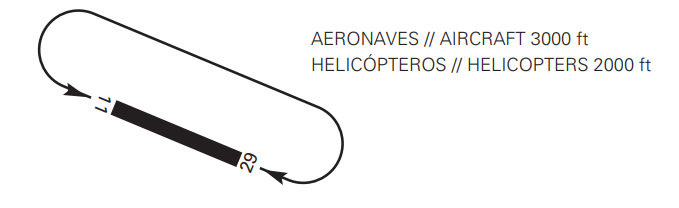
AD TRAFFIC CIRCUIT
ADDITIONAL INFORMATION
Slope of Apron General Aviation above 1%.
It is mandatory to use blocks in stands of General Aviation Apron.
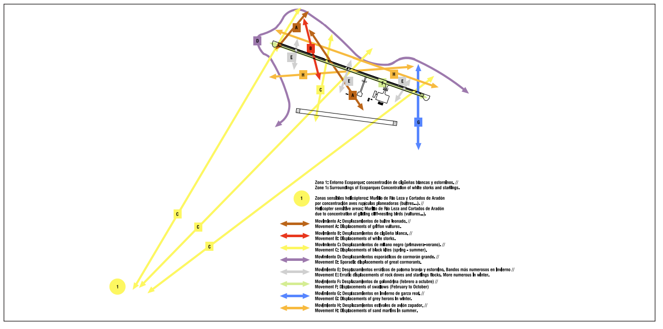
BIRD CONCENTRATION AREAS
AERONAUTICAL CHARTS RELATED TO AN AERODROME
The list of charts related to the aerodrome can be found on the link below:
VISUAL SEGMENT SURFACE (VSS) PENETRATION
The instrument approach procedures affected can be found below:
- IAC 1 RNP RWY 11 (LPV ONLY): LPV.
- IAC 2 RNP RWY 29 (LPV ONLY): LPV.
- IAC 3 ILS Z RWY 29: direct approach.
- IAC 4 ILS Y RWY 29: direct approach.
- IAC 5 LOC RWY 29: direct approach.