LETO AD 2 AERODROME DATA
AERODROME LOCATION INDICATOR AND- NAME
LETO - MADRID/Torrejón
AERODROME GEOGRAPHICAL AND ADMINISTRATIVE DATA
ARP |
402948N 0032645W. See AD 2-LETO ADC. |
|
Distance and direction from city |
24 km E. |
|
Elevation |
618 m / 2026 ft. |
|
Geoid undulation |
51.39 m ± 0.05 m (1). |
|
Reference temperature |
34°C. |
|
Low average temperature |
5°C. |
|
Magnetic variation |
0° (2020). |
|
Annual change |
8.1'E. |
|
AD administration |
Ejército del Aire y del Espacio. |
|
Address |
Base Aérea de Torrejón; Ctra. Madrid-Barcelona km 22.800 |
|
TEL |
+34-916 274 710 |
|
FAX |
+34-916 274 617 |
|
AFTN |
LETO |
|
Approved traffic |
IFR/VFR. |
|
Remarks |
(1) For all AD points. |
OPERATIONAL HOURS
Airport |
H24 (1). |
|
Customs and Immigration |
No. |
|
Health and Sanitation |
No. |
|
AIS/ARO/OPV |
HR AD. |
|
MET briefing |
HR AD. |
|
ATS |
HR AD. |
|
Fuelling |
HR AD. |
|
Handling |
HR AD. |
|
Security |
HR AD. |
|
De-icing |
HR AD. |
|
Remarks |
(1) Foreign state aircraft will request compulsory PPR at least with 72 HR in advance. As a general rule, PPR will not be accepted from:
|
HANDLING SERVICES AND FACILITIES
Cargo facilities |
SATA CAT I.
|
|
Fuel types |
F-34. |
|
Oil types |
O-113, O-133, O-142, O-147, O-148, O-156, O-158, O-190, O-226, O-228, O-237, O-238, O-1236. |
|
Refuelling capacity |
trucks 40000 L, 22.5 L/s. |
|
De-icing facilities |
No. |
|
Hangar space |
No. |
|
Repair facilities |
No. |
|
Remarks |
GPU: Unit of AC (up to 100 KVA) and DC(up to 2500 A). |
PASSENGER FACILITIES
Hotels |
Yes. |
|
Restaurant |
Yes. |
|
Transportation |
Buses and light vehicles on request. |
|
Medical facilities |
No. |
|
Bank / Post office |
Yes / No. |
|
Tourist Information |
No. |
|
Remarks |
None. |
RESCUE AND FIRE FIGHTING SERVICES
Fire category |
8. |
|
Rescue equipment |
In accordance with the fire category published. |
|
Removal of disabled aircraft |
Self-propelled crane for lifting any aircraft weighing no more than 30 TM. Low pressure bags up to 13 TM. Hydraulic jacks up to 15 TM. |
|
Remarks |
None. |
RUNWAY SURFACE CONDITION ASSESSMENT AND REPORTING, AND SNOW PLAN
Equipment |
Snow blower sweepers, breakdown truck. |
|
Priority |
Runways, taxiways and apron. |
|
Remarks |
None. |
APRONS, TAXIWAYS AND CHECK LOCATIONS/POSITIONS DATAMOVEMENT AREA DETAILS
Apron |
Surface: Concrete. |
|
Taxiways |
Width: |
|
Check locations |
Altimeter: PE 1: 596.96 m / 1958.51 ft. |
|
Remarks |
None. |
SURFACE MOVEMENT GUIDANCE AND CONTROL SYSTEM AND MARKINGSTAXIING GUIDANCE SYSTEM AND MARKINGS
Taxiing guidance system |
Boards at RWY/TWY intersections, parking line boards on TWY edge, runway-holding positions, stop bars, apron security line and stands. |
|
RWY markings |
Designators, threshold, centre line, edge, touchdown zone, aiming point, runway distance remaining sign, side stripe and pre-threshold area. |
|
TWY markings |
Centre line and edge. |
|
Remarks |
None. |
AERODROME OBSTACLES
In the approach and take-off areas |
In the circuit area and at the AD |
|||
|---|---|---|---|---|
RWY area |
Obstacle |
Coordinates |
Obstacle |
Coordinates |
04 APCH / 22 TKOF |
Mound |
8.9 km / 219° MAG FM THR 04 |
Mound |
4.8 km / 022° MAG FM THR 22 |
Contour line |
3.3 km / 226° MAG FM THR 04 |
Plateau |
5.7 km / 169° MAG FM THR 22 |
|
22 APCH / 04 TKOF |
Mound |
14 km / 036° MAG FM THR 22 |
Water reservoir |
2.4 km / 190° MAG FM THR 22 |
Mound |
9.0 km / 039° MAG FM THR 22 |
Radio antennas |
2.1 km / 235° MAG FM THR 22 |
|
Contour line |
1.7 km / 049° MAG FM THR 22 |
Radar antennas |
7.1 km / 257° MAG FM THR 22 |
|
Remarks: See AD 2-LETO AOC. |
||||
METEOROLOGICAL INFORMATION PROVIDEDMETEOROLOGICAL SERVICE PROVIDED
MET office |
Torrejón OMD. |
|
HR |
H24. |
|
METAR |
Half-hourly. |
|
TAF |
24 HR. |
|
TREND |
Yes. |
|
Briefing |
In person and by phone. |
|
Flight documentation / Language |
Plain language / Spanish. |
|
Charts |
Significant, forecasted in altitude (wind and temperature) and maximum wind maps. |
|
Supplementary equipment |
Cloud imagery, lightning and radar information display. |
|
ATS unit served |
TWR, APP, OPV. |
|
Additional information |
Madrid OMAe (LEMC): H24
Torrejón OMD
|
|
Remarks |
None. |
RUNWAY PHYSICAL CHARACTERISTICS
RWY |
Direction |
DIM (m) |
THR PSN |
TDZ ELEV |
SWY (m) |
CWY (m) |
Strip (m) |
OFZ |
RESA (m) |
RWY/SWY SFC |
|
|---|---|---|---|---|---|---|---|---|---|---|---|
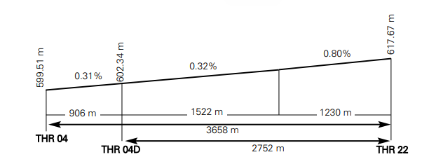
04 |
043.40° GEO |
3658 x 60 |
402905.18N |
THR: 599.5 m / 1967 ft |
85 x 60 |
No |
4338 x 150 |
No |
240 x 150 |
RWY: ASPH |
|
04D (1) |
043.40° GEO |
2752 x 60 |
402926.99N |
THR: 602 m / 1976 ft |
85 x 60 |
No |
4338 x 150 |
No |
240 x 150 |
RWY: ASPH |
|
22 |
223.40° GEO |
3658 x 60 |
403031.39N |
THR: 617.7 m / 2026 ft |
595 x 60 |
No |
4338 x 150 |
No |
240 x 150 |
RWY: ASPH |
|
Remarks: (1) RWY 04D only usable by military aircraft making the turn for landing within 2.5 DME TJZ or before R-143 VTZ. |
|||||||||||
Profile
DECLARED DISTANCES
RWY |
TORA (m) |
TODA (m) |
ASDA (m) |
LDA (m) |
|---|---|---|---|---|
04 |
3658 |
3658 |
3743 |
3658 |
04D (1) |
2752 |
2752 |
2837 |
2752 |
22 |
3658 |
3658 |
4253 |
3658 |
04 INT C2,C8 |
3198 |
3198 |
3283 |
– |
04 INT C3 |
2605 |
2605 |
2690 |
– |
22 INT C4 |
2347 |
2347 |
2942 |
– |
22 INT C7 |
3247 |
3247 |
3842 |
– |
22 INT C9 |
2347 |
2347 |
2960 |
– |
Remarks |
(1) RWY 04D only usable by military aircraft making the turn for landing within 2.5 DME TJZ or before R-143 VTZ. |
|||
APPROACH AND RUNWAY LIGHTING
Runway |
04 |
|
Approach |
Precision CAT I 900 m. LIH (1). Threshold identification lights. |
|
PAPI (MEHT) |
3° (17.97 m / 59 ft). |
|
Threshold |
Green. |
|
Touchdown zone |
No. |
|
Runway centre line |
3658 m: 2758 m white + 600 m red and white + 300 m red. LIH (1). |
|
Runway edge |
3658 m: 3058 m white + 600 m yellow. LIH (1). |
|
Runway end |
Red. |
|
Stopway |
Red. |
|
Remarks |
(1) Adjustable light intensity. |
Runway |
04D |
|
Approach |
Simple 420 m. Threshold identification lights. |
|
PAPI (MEHT) |
3° (13.91 m / 46 ft). |
|
Threshold |
Green. |
|
Touchdown zone |
No. |
|
Runway centre line |
2752 m: 1852 m white + 600 m red and white + 300 m red. LIH (1). |
|
Runway edge |
2752 m: 2152 m white + 600 m yellow. LIH (1). |
|
Runway end |
Red. |
|
Stopway |
Red. |
|
Remarks |
(1) Adjustable light intensity. |
Runway |
22 |
|
Approach |
Precision CAT I 900 m. LIH (1). Threshold identification lights. |
|
PAPI (MEHT) |
3° (16.25 m / 53 ft). |
|
Threshold |
Green with wing bar. |
|
Touchdown zone |
No. |
|
Runway centre line |
3658 m: 2758 m white + 600 m red and white + 300 m red. LIH (1). |
|
Runway edge |
3658 m: 3058 m white + 600 m yellow. LIH (1). |
|
Runway end |
Red. |
|
Stopway |
Red. |
|
Remarks |
(1) Adjustable light intensity. |
OTHER LIGHTING, SECONDARY POWER SUPPLY
ABN/IBN |
402921N 0032608W. See AD 2-LETO ADC. |
|
WDI/LDI |
1 near THR 04, 1 near THR 22, 1 near TWY C8. |
|
TWY lighting |
Edge. |
|
Apron lighting |
PE 1, PE 7 and PE 8: 2 Floodlighting poles. |
|
Secondary power supply |
Engine generators that provide a maximum switchover time (light) of 15 seconds for all the lighting systems. |
|
Remarks |
None. |
HELICOPTER LANDING AREA
Position |
NE of ARP: 40º30’02.550’’N 003º27’02.600’’W (1)(2). |
|
Elevation |
610 m (2011.29 ft). |
|
Dimensions, surface, maximum weight, marking |
- Main apron: 24.5 m x 24.5 m, base concrete. |
|
Direction |
No. |
|
Declared distances |
No. |
|
Lighting |
Edge marking and two floodlighting poles. |
|
Remarks |
(1) See AD 2-LETO ADC. |
AIR TRAFFIC SERVICES AIRSPACE ATS AIRSPACE
Designation |
CTR MADRID. |
|
Lateral limits |
403301.53N 0034658.39W; arc centred on DVOR/DME BRA (402808.9N 0033327.1W), radius 11.4 NM; 402158.81N 0032053.71W; 401544.73N 0031457.24W; 400611.28N 0032929.16W; 401222.89N 0033746.85W; 400809.08N 0034614.61W; 401320.10N 0035258.35W; 401642.37N 0034856.17W; arc centred on MADRID/Getafe AD (401738.6N 0034325.4W), radius 8.0 km; 402038.71N 0034729.48W; arc centred on MADRID/Cuatro Vientos AD (402214.4N 0034706.5W), radius 3.0 km; 402146.76N 0034504.54W; arc centred on MADRID/Getafe AD (401738.6N 0034325.4W), radius 8.0 km; 402154.86N 0034232.04W; 402308.24N 0034112.60W; 403301.53N 0034658.39W. |
|
Vertical limits |
SFC-1000 ft AGL. |
|
Airspace class |
D (1). |
|
Unit |
MADRID APP. |
|
Language |
ES/EN. |
|
Transition altitude |
3962 m / 13000 ft. |
|
Hours of applicabilty |
- |
|
Remarks |
(1) Visual flights only allowed to Spanish military aircraft from/to Ministerio de Defensa facilities. |
Designation |
ATZ MADRID/TORREJÓN. |
|
Lateral limits |
8 km radius circle centred on 402956N 0032644W (2). |
|
Vertical limits |
SFC-3000 ft AGL (3). |
|
Airspace class |
D. |
|
Responsible unit |
TORREJÓN TWR. |
|
Language |
ES/EN. |
|
Transition altitude |
- |
|
Hours of applicabilty |
- |
|
Remarks |
(2) Or the ground visibility, whichever is lower |
AIR TRAFFIC SERVICES COMMUNICATION FACILITIESATS COMMUNICATION FACILITIES
Service |
Call sign |
FREQ |
HR |
Remarks |
|---|---|---|---|---|
APP |
Madrid APP |
124.230 C |
H24 |
APP/L, DEP W |
127.100 MHz |
H24 |
|||
127.505 C |
H24 |
|||
131.175 MHz |
H24 |
DEP E |
||
376.250 MHz |
H24 |
MIL |
||
APP |
Torrejón APP |
119.950 MHz |
H24 |
MIL |
258.925 MHz |
H24 |
MIL |
||
254.975 MHz |
H24 |
MIL |
||
TWR |
Torrejón TWR |
118.300 MHz |
H24 |
GMC |
121.500 MHz |
H24 |
EMERG |
||
122.100 MHz |
H24 |
MIL |
||
136.275 MHz |
H24 |
BACK-UP |
||
139.300 MHz |
H24 |
MIL |
||
243.000 MHz |
H24 |
EMERG |
||
257.800 MHz |
H24 |
MIL |
||
339.600 MHz |
H24 |
MIL |
||
396.900 MHz |
H24 |
GMC MIL |
||
GCA |
Torrejón GCA |
118.900 MHz |
H24 |
MIL. HR MAINT PAR/ASR: MON 1530-1900 LT |
123.300 MHz |
H24 |
MIL |
||
125.300 MHz |
H24 |
MIL |
||
343.875 MHz |
H24 |
MIL |
||
356.150 MHz |
H24 |
MIL |
||
374.525 MHz |
H24 |
MIL |
RADIO NAVIGATION AND LANDING AIDSRADIO NAVIGATION & LANDING FACILITIES
Facility (VAR) |
ID |
FREQ |
HR |
Coordinates |
DME ELEV |
Remarks |
|---|---|---|---|---|---|---|
DVOR (1° W) |
VTZ |
115.100 MHz |
H24 |
402832.2N 0032819.3W |
- |
HR MAINT: MON 1530-1830 LT. |
DME |
VTZ |
CH 98X |
H24 |
402832.2N 0032819.3W |
660 m |
HR MAINT: MON 1530-1830 LT. |
LOC 22 (1° W) ILS CAT I |
ITJA |
109.500 MHz |
H24 |
402843.1N 0032805.8W |
- |
224° MAG / 935 m FM THR 04; |
GP 22 |
332.600 MHz |
H24 |
403024.3N 0032607.1W |
- |
3°; RDH 16.8 m; at 404 m FM THR 22 & 110 m FM RCL to the right in APCH direction. |
|
ILS/DME |
ITJA |
CH 32X |
H24 |
403024.3N 0032607.1W |
622 m |
REF DME THR 22. |
TACAN (1° W) |
TJZ |
CH 72X |
H24 |
402956.0N 0032643.8W |
600 m |
R-090/R-170: possible loss of signal BTN 20 NM & 25 NM BLW 6000 ft AMSL. |
LOCAL AERODROME REGULATIONSLOCAL REGULATIONS
ATC PROCEDURES
REDUCED RUNWAY SEPARATION MINIMA ON THE SAME RUNWAY
Although the runway may temporarily be occupied by an aircraft landing or taking off, clearance to land may be granted to a subsequent aircraft, provided that:
-
There is a distance between aircraft of at least 2000 m from the THR, and
-
The aerodrome ATC is certain that, when an aircraft cleared in this way will cross the threshold, there will be appropiate separation from the preceding one
This procedure may be used notwithstanding to the requirements established in the Reglamento de la Circulación Aérea regarding the use of conditional phrases for movements affecting the active runway or runways.
These minima shall apply between sunrise and sunset only, and under the following conditions:
-
Wake turbulence separation minima shall be maintained.
-
While Visual Meteorological Conditions (VMC) prevail at the aerodrome.
-
When braking action is not adversely affected by precipitants on the runway (slush, water, etc.).
-
When the aircraft involved operate normally.
When issuing the landing clearance in accordance with this procedure, the following instructions shall be used:" ... (Call sign) BEHIND LANDING / DEPARTING (aircraft type), CLEARED TO LAND RUNWAY (number)"
AIR/GROUND COMMUNICATION FAILURE PROCEDURES
AIR COMMUNICATION FAILURE
Any aircraft experiencing a communication failure shall immediately respond on SSR mode 7600.
VFR flight in VMC
- Jet aircraft shall proceed through one of the two published visual corridors and overfly the apron at 500 ft AGL while rocking its wings and maintaining a heading of 219º. When over the TWR, pilots shall check the runway in use. If RWY 22 is in use, they shall break to the left and enter the traffic pattern tailwind, and if RWY 04 is in use, they shall take the opposite heading, conducting an offset entry, entering the traffic pattern tailwind while waiting for light signals from TWR.
- Conventional aircraft proceeding through the North visual corridor, over Daganzo, shall descend to 500 ft AGL and fly "ABEAM" downwind, rocking its wings heading for TWR. Once the runway in use has been determined, they shall await light signals from TWR. If proceeding through the South visual corridor, over Meseta de San Juan, they shall descend to 500 ft AGL and overfly the apron while rocking their wings heading 219º. When over the TWR, pilots shall check the runway in use. If the runway in use is 22, they shall break to the left and enter the traffic pattern downwind leg; if RWY 04 is in use, they shall take the opposite heading conducting an offset entry, entering the traffic pattern downwind leg while awaiting light signals from TWR.
Note: Neither the runway nor its centreline extension shall be over flown in any case.
VFR flights (Change in the meteorological conditions from VMC to IMC)
When the meteorological conditions deteriorate progressively, making it impossible to maintain uninterrupted visual contact with the ground, aircraft shall climb to the last cleared level acknowledged or to the minimum safety altitude, whichever is higher, and maintain this level until reaching one of the entry points (STAR's), and head to DUKKE (IAF). At this point, the holding pattern at 6000 ft must be abandoned and a descent started in order to shoot one of the published IFR approaches on RWY 22. If RWY 04 is in use, the procedure shall be carried out in the same way and when the airfield is in sight, a "circling" manoeuvre must be executed to land on RWY 04.
IFR flights
- When the communication failure occurs during the STAR procedure before reaching the IAF:
Proceed to the designated IAF (DUKKE) from the cleared STAR (in accordance with the FPL), maintaining the last assigned level or altitude acknowledged, and enter the holding pattern. Begin the descent after completing one holding pattern turn (leaving the holding pattern at 6000 ft), or at the EAT whichever occurs later, in order to shoot one of the IFR approaches published for the RWY in service and land in the following 30 minutes.
- When the failure occurs during radar vectoring before the IAF:
The aircraft will proceed through the most direct way to intercept the STAR until reaching the IAF, and must follow the communication failure procedure during the STAR manoeuvre.
- When the failure occurs during radar vectoring after crossing the IAF:
The aircraft will proceed through the most direct way to intercept the STAR until reaching the lAF, and must follow the communication failure procedure during the STAR manoeuvre.
- When the failure occurs during radar vectoring after crossing the IAF:
The aircraft shall maintain the last cleared altitude acknowledged, and proceed to intercept the final approach course and complete the landing manoeuvre. If this is not possible, aircraft shall conduct the communication failure missed approach procedure.
- If the failure occurs during the missed approach, aircraft:
Shall not begin the missed approach before the MAPT. Shall begin the missed approach procedure according to the corresponding IAC. Complete at least one holding pattern turn over the IAF, in order to shoot the approach and land.
- When the failure occurs during the SID:
The aircraft shall continue with the SID up to the TMA exit point, climbing to the last cleared level acknowledged or to the minimum safety altitude, whichever is higher, and maintain this altitude during 7 minutes, in accordance with the maximum levels in the departure charts and continuing the flight with respect to the filed FPL. In case the aircraft is in the Torrejón Delegated Airspace, if the Pilot in Command decides to return to the departure aerodrome, they shall follow the appropriate procedure, as described above.
- When the failure occurs during the departure under radar vectoring: The aircraft shall proceed by the most direct route to intercept the last SID procedure received from ATC, continue with the communication failure procedure during the SID. If SID authorisation is not received, proceed to intercept the appropriate SID to TMA exit point and in accordance with the type of navigation expressed in the updated FPL.
GROUND COMMUNICATION FAILURE
If an aircraft or vehicle operating in the manoeuvering area experiences a communication failure, proceed as follows:
-
If the aircraft is on departure: continue on the assigned route and stop at an intermediate holding position or clearance limit, taking extreme care to avoid detours . Once there, hold position and wait for the arrival of a "FOLLOW ME" vehicle which will lead you to the parking position.
-
In the case of a vehicle: remain in position and await the arrival of a "FOLLOW ME" vehicle which will assist as appropriate.
VFR FLIGHTS IN VMC CONDITIONS (CHECK RWY IN USE AND WAIT FOR LIGHT SIGNALS) |
||
|---|---|---|
RWY 22 |
RWY 04 |
|
JET AIRCRAFT: |
Break to the left and enter downwind |
Reverse to the opposite heading (offset entry). Enter downwind |
CONVENTIONAL AIRCRAFT: |
Enter downwind while rocking |
Enter downwind while rocking |
CONVENTIONAL AIRCRAFT: |
Break to the left and enter downwind |
Reverse to the opposite heading (offset entry). Enter downwind |
VFR FLIGHTS IN IMC CONDITIONS |
||
ACTIONS |
RWY 22: DUKKE 6000 ft and carry out IAC |
RWY 04: DUKKE 6000 ft and carry out IAC and subsequent circling |
IFR FLIGHT |
|
|---|---|
FAILURE MOMENT |
ACTIONS |
STAR BEFORE IAF |
Proceed to IAF (DUKKE) maintain the last cleared level and enter in holding pattern. |
RADAR VECTORING BEFORE IAF |
As for STAR failure before IAF. |
RADAR VECTORING AFTER IAF |
Maintain cleared altitude. |
MISSED APPROACH |
Do not begin missed approach before MAPT. |
DURING SID |
Continue SID to TMA exit point. |
DEPARTURE UNDER RADAR VECTOR |
Proceed directly and intercept the SID procedure received from ATC. |
NOISE ABATEMENT PROCEDURES
No.
FLIGHT PROCEDURES
ADJUSTMENT OF VERTICAL SPEED IN MADRID TMA
Aircraft in evolution shall adjust their vertical speed when approaching the assigned altitude or flight level. In those circumstances, vertical speed shall be reduced to 1500 ft per minute when approaching a vertical distance of 1000 ft above or below the assigned altitude or flight level.
All aircraft flying under RCAO rules take-off from RWY 22 or in south visual circuit, shall not exceed 2.5 DME TJZ or R-143 VTZ on the southwest side of the aerodrome. If such is not possible, the aircraft shall notify this event to LETO TWR-APP/GCA before take-off or before entering the visual circuit.
Caution, traffic in approach or departure close to airport Adolfo Suárez Madrid-Barajas
VFR CORRIDORS SPEED LIMIT
The maximum speed in conventional VFR corridors is limited to 220 Kt. The maximum speed in VFR jet corridors is limited to 350 Kt, unless authorized by the Control Agency.
MILITARY AD TRAFFIC CIRCUIT
CONVENTIONAL AIRCRAFT
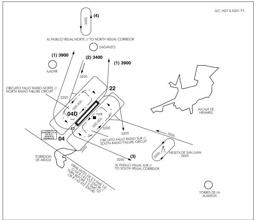
(1) Aircraft departing from RWY 04/22 destination the North visual corridor, shall climb to reach 3900 ft altitude unless otherwise instructed by TWR. Caution due to possible traffic in holding pattern at 3400 ft North of Daganzo.
(2) Aircraft coming from the North visual corridor descending to reach the traffic pattern altitude
(3) Aircraft departing from RWY 04/22 destination the South visual corridor, shall always leave Meseta de San Juan to the left.
(4) Holding pattern North of Daganzo, turning left at 3400 ft, without overflying the village of Daganzo.
MILITARY AD TRAFFIC CIRCUIT
JET AIRCRAFT
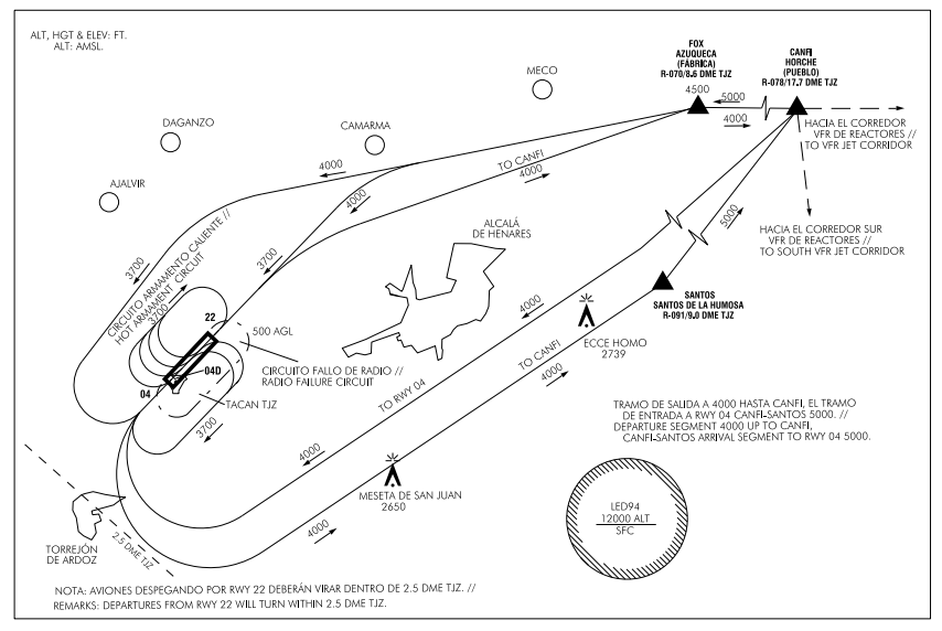
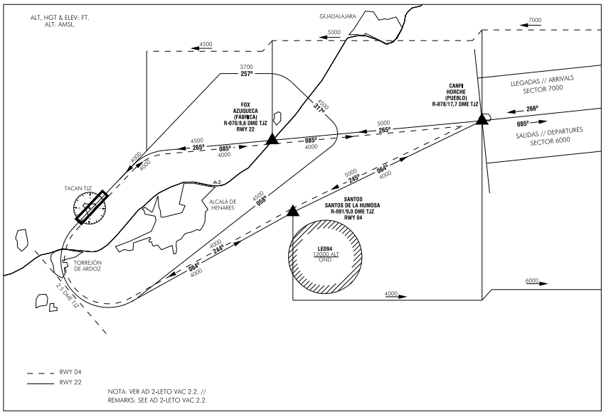
VISUAL APPROACH ROUTES DETAILS
ADDITIONAL INFORMATION
ARRESTING SYSTEMS
Nomenclature |
LETO-01-R-U |
|
Type |
NET BARRIER UNIDIRECTIONAL. |
|
Location on |
RWY 22 THR +3758 m / 12329 ft. |
|
Readiness status |
Permanently available, on pilot request. |
Nomenclature |
LETO-02-C-B |
|
Type |
RETRACTABLE CABLE BARRIER BIDIRECTIONAL. |
|
Location on |
RWY 04 THR +550 m / 1804 ft. |
|
Readiness status |
Permanently available, on pilot request. |
Nomenclature |
LETO-03-C-B |
|
Type |
RETRACTABLE CABLE BARRIER BIDIRECTIONAL |
|
Location on |
RWY 04 THR +1829 m / 6001 ft. |
|
Readiness status |
Permanently available, on pilot request. |
Nomenclature |
LETO-04-C-B |
|
Type |
RETRACTABLE CABLE BARRIER BIDIRECTIONAL. |
|
Location on |
RWY 04 THR +3098 m / 10164 ft. |
|
Readiness status |
Permanently available, on pilot request. |
Nomenclature |
LETO-05-R-U |
|
Type |
NET BARRIER UNIDIRECTIONAL. |
|
Location on |
RWY 04 THR +3698 m / 12133 ft. |
|
Readiness status |
Permanently available, on pilot request. |
RADAR INSTRUMENT APPROACH MINIMA (EXCLUSIVE MILITARY USE)
RWY |
GP/TCH/RPI |
CAT |
DH/MDA - VIS |
HAT/HAA |
CEIL - VIS |
|
|---|---|---|---|---|---|---|
PAR (3) |
22 |
3° / 49 / 1033 |
A B C D E |
2226 - 800 m |
200 |
200 - 800 m |
SRE |
22 |
A B |
2680 - 800 m (1) |
682 |
700 - 800 m (1) |
|
C |
2680 - 2000 m |
682 |
700 - 2000 m (1) |
|||
D HPMA |
2680 - 2400 m |
682 |
700 - 2400 m (1) |
|||
SRE |
04 |
A B |
2330 - 800 m (1) |
363 |
400 - 800 m (1) |
|
C |
2330 - 1200 m (2) |
363 |
400 - 1200 m (2) |
|||
D HPMA |
2330 - 1200 m |
363 |
400 - 1200 m (1) |
|||
CIR |
A |
2580 - 1600 m |
554 |
600 - 1600 m |
||
B |
2900 - 2000 m |
874 |
900 - 2000 m |
|||
C |
3060 - 4800 m |
1034 |
1100 - 4800 m |
|||
D |
3140 - 4800 m |
1114 |
1200 - 4800 m |
|||
HPMA |
2900 - 4400 m |
874 |
900 - 4400 m |
Remarks:
(1) When ALS U/S increase VIS 800 m.
(2) When ALS U/S increase VIS 400 m.
(3) For the PAR approach, the missed approach instructions shall be:“Climb on RWY heading to 2600 ft, turn left inside 2.5 DME TJZ or coordinates 402956.0N 0032643.8W on track 045º, to intercept and follow R-075 TJZ direct to DUKKE climbing to 6000 ft”.
BIRD CONCENTRATION AREAS AROUND THE TORREJÓN AIR BASE
BIRD CONCENTRATION AREAS
Area 1: concentration of starlings and lapwings.
Area 2: concentration of wood pigeons and rock doves.
FEEDING AND WATERING AREAS
Area I: grasses and grain crops.
Area II: invertebrates, amphibians, fish and water.
BIRD MOVEMENT AREAS
Movement A: movement of vultures and other birds of prey.
Movement B: movement of pigeons.
Movement C: movement of starlings and lapwings (winter months).
Movement D: movement of lesser black-backed gulls (winter months).
Movement E: movement of white storks.
AERONAUTICAL CHARTS RELATED TO AN AERODROMECHARTS RELATED TO THE AERODROME
The list of charts related to the aerodrome can be found at the following link:
VISUAL SEGMENT SURFACE (VSS) PENETRATION
Not applicable.