LEAS AD 2 AERODROME DATA
AERODROME LOCATION INDICATORAND - NAME
LEAS - ASTURIAS
AERODROME GEOGRAPHICAL AND ADMINISTRATIVE DATA
ARP |
433349N 0060205W. See AD 2-LEAS ADC. |
|
Distance and direction from the city |
13 km W. |
|
Elevation |
127 m / 416 ft. |
|
Geoid undulation |
52.73 ± 0.05 m (1). |
|
Reference temperature |
22°C. |
|
Low average temperature |
8ºC. |
|
Magnetic variation |
0º (2025). |
|
Annual change |
10.4' E. |
|
AD administration |
Aena. |
|
Address |
Aeropuerto de Asturias; 33459 Santiago del Monte (Castrillón) Asturias. |
|
TEL |
+34-985 127 500 |
|
| FAX | +34-985 127 516 | |
AFTN |
LEAS |
|
Approved traffic |
IFR/VFR. |
|
Remarks |
(1) For all AD points. |
OPERATIONAL HOURS
Airport |
V: 0440-2330, PS 1 HR PPR 1 HR BFR AD CLSD. I: 0540-2315, PS 1 HR AND 30 MIN PPR 1 HR BFR AD CLSD. |
|
Customs and Immigration |
HR AD. |
|
Health and Sanitation |
See GEN 1.4. |
|
AIS |
H24 (1). |
|
| ARO | HR AD (2). | |
MET briefing |
HR AD PS 55 MIN BFR HR AD. |
|
ATS |
V: 0425-2350, PS 1 HR PPR 1 HR BFR AD CLSD. I: 0525-2335, PS 1 HR AND 30 MIN PPR 1 HR BFR AD CLSD |
|
Fuelling |
V: 0410-2330, PS 1 HR PPR BFR AD CLSD. |
|
Handling |
HR AD. |
|
Security |
H24. |
|
De-icing |
No. |
|
Remarks |
(1) Centralised AIO Office - International NOTAM Office:
(2) ARO service provided by the Operations Office of the airport. |
HANDLING SERVICES AND FACILITIES
Cargo facilities |
Up to 10000 kg. |
|
Fuel types |
100LL, JET A-1 (1). |
|
Oil types |
AEROSHELL W100. |
|
Refuelling capacity |
JET A-1:
|
|
De-Icing facilities |
No. |
|
Hangar space |
No. |
|
Repair facilities |
No. |
|
Remarks |
It is compulsory to hire ground handling services for all operations, including non-commercial ones. During arrival operations, passengers and cabin crew shall wait on board the aircraft for ground handling staff to arrive. At the very least, a Category 5 apron, aircraft assistance, must be hired. Additionally, whenever there are passengers whose arrival or destination is a NON-SCHENGEN airport, Category 2, passenger assistance, must be hired. Exemptions: State, hospital, SAR, military, humanitarian and fire-fighting flights.
Ramp agents: Both for Commercial and General and Executive Aviation: Only for General and Executive Aviation: |
PASSENGER FACILITIES
Hotels |
No. |
|
Restaurant |
Yes. |
|
Transportation |
Taxis, hire cars, buses. |
|
Medical facilities |
No. |
|
Bank/Post Office |
Cash dispenser / No. |
|
Tourist information |
Yes. |
|
Remarks |
None. |
RESCUE AND FIREFIGHTING SERVICES
Fire category |
7. (1) |
|
Rescue equipment |
In accordance with the fire category published. |
|
Removal of disabled aircraft |
Local companies, response time: regular hours: 45 to 60 min; night and weekend: 90 min. MAX ACFT that can be moved: code letter E ACFT. (2) |
|
Remarks |
(1) 8 on request, according to procedure (see item 20). (2) Person responsible for coordinating aircraft transfer operations: Operations Officer / Service executive. Contact via the airport Operations Office:
|
RUNWAY SURFACE CONDITION ASSESSMENT AND REPORTING, AND SNOW PLAN
Types of clearing equipment |
Snowplough with 4 m snowplough blade and 5 m3 urea spreader incorporated. |
|
Clearance priorities |
Runway, TWY C, A, PRKG 02, 03 and 04, apron service road and rest of stands. |
|
Use of material for movement area surface treatment |
Urea (UREA). |
|
Specially prepared winter runways |
Not applicable. |
|
Remarks |
Period of application of snow plan: 01-DEC to 28/29-FEB. Runway surface condition assessment and reporting in accordance with the Global Reporting Format (GRF) methodology described in AD 1.2.2. Aerodrome in service during all seasons of the year. |
APRONS, TAXIWAYS AND CHECK LOCATIONS/POSITIONS DATAMOVEMENT AREA DETAILS
Apron |
Surface: Concrete. Strength:
|
|
Taxiways |
Width: 23 m; EXC A: 32.5 m. Surface: Asphalt.
|
|
Check locations |
Altimeter: Apron ELEV 128 m / 420 ft. |
|
Remarks |
None. |
SURFACE MOVEMENT GUIDANCE AND CONTROL SYSTEM AND MARKINGSTAXIING GUIDANCE SYSTEM AND MARKINGS
Taxiing guidance system |
Horizontal marking, runway-holding position, intermediate holding position, stop bars, lights of intermediate holding position, lighted boards, NO ENTRY signs, runway guard lights, NO-ENTRY bar in TWY D, stands.
|
|
RWY markings |
Designators, threshold, centre line, aiming point, side stripe and touchdown zone. (1) |
|
TWY markings |
Centre line and side stripe. |
|
Remarks |
(1) The lengths of the TDZ on RWY 29 up to 600 m. |
AERODROME OBSTACLES
Obstacles which penetrate Approach, Take-Off Climb, Conical, Inner Horizontal, Transitional, Inner Transitional and Balked Landing Surfaces established in ICAO Annex 14; and the areas 2A and 3 established in ICAO Annex 15. Those penetrating these surfaces are identified in the CSV file as “Relevante_Relevant = Si/Yes”. |
See Item 10 and Data Set. |
|
Remarks |
See AD 2-LEAS AOC. |
METEOROLOGICAL INFORMATION PROVIDEDMETEOROLOGICAL SERVICE PROVIDED
MET office |
Asturias EMAe. |
|
HR |
HR AD PS 55 MIN BFR HR AD. Outside this schedule, a half-hourly METAR AUTO will be issued. |
|
METAR |
Half-hourly. |
|
TAF |
24 HR. |
|
TREND |
Yes. |
|
Briefing |
In person and by telephone. |
|
Flight documentation/Language |
Charts and plain language/Spanish. |
|
Charts |
Significant, forecast at altitude (wind and temperature) and maximum wind maps. |
|
Supplementary equipment |
Cloud images, lightning and radar information display. |
|
ATS unit served |
TWR, APP. |
|
Additional information |
Santander OMAe (LESD): H24
Asturias EMAe: HR AD |
|
Remarks |
Aerodrome climatological summary available. Aerodrome warnings available. |
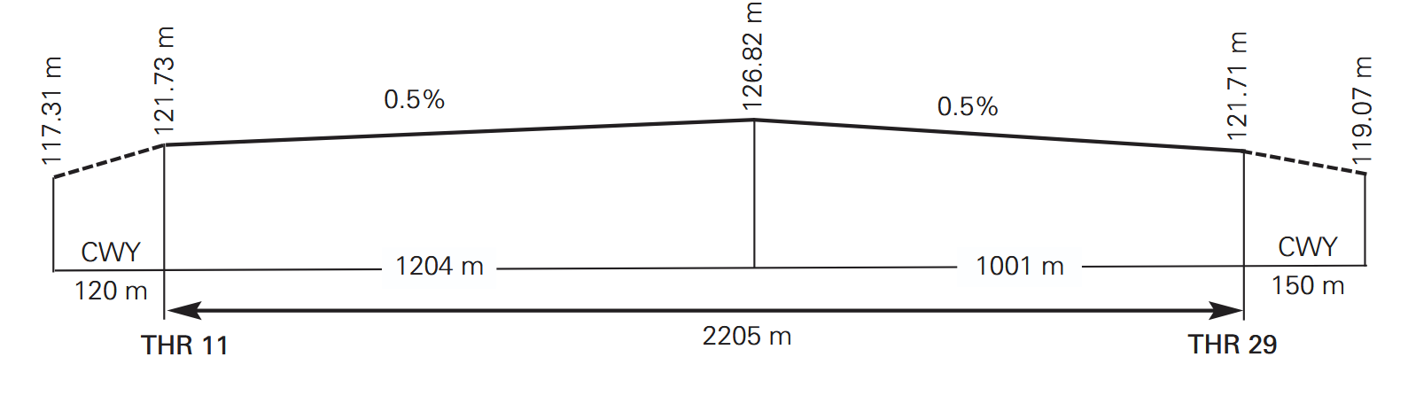
RUNWAY PHYSICAL CHARACTERISTICS
RWY |
Direction |
DIM (m) |
THR PSN |
THR ELEV TDZ ELEV |
SWY (m) |
CWY (m) |
Strip (m) |
OFZ |
RESA (m) |
RWY/SWY SFC PCN |
|---|---|---|---|---|---|---|---|---|---|---|
11 |
108.03° GEO 108° MAG |
2205 x 45 |
433359.90N |
THR: 122 m / 399 ft TDZ: No |
No |
150 x 150 |
2325 x 280 (1) |
No |
90 x 90 |
RWY: ASPH PCN 110/F/A/W/T (2) SWY: No |
29 |
288.05° GEO 288° MAG |
2205 x 45 |
433337.79N |
THR: 121.7 m / 399 ft TDZ: 126.2 m / 414 ft |
No |
120 x 150 |
2325 x 280 (1) |
Yes |
90 x 90 |
RWY: ASPH PCN 110/F/A/W/T (2) SWY: No |
Remarks: (1) Irregular strip layout at the beginning of RWY 11. (See AD 2-LEAS ADC). (2) First 150 m from THR 11 and first 135 m from THR 29: PCN 66/F/A/W/T. |
||||||||||
Profile
DECLARED DISTANCES
RWY |
TORA (m) |
TODA (m) |
ASDA (m) |
LDA (m) |
|---|---|---|---|---|
11 |
2205 |
2355 |
2205 |
2205 |
29 |
2205 |
2325 |
2205 |
2205 |
11 INT C |
845 |
995 |
845 |
- |
29 INT C |
1383 |
1503 |
1383 |
- |
Remarks: None. |
||||
APPROACH AND RUNWAY LIGHTING
Runway |
11 |
|
Approach |
Threshold identification lights. |
|
PAPI (MEHT) |
3° (15.98 m / 52 ft). (1) |
|
Threshold |
Green with wing bar. |
|
Touchdown zone |
No. |
|
Runway centre line |
2205 m: 1305 m white + 600 m white and red + 300 m red. LIH. |
|
| Runway edge | 2205 m: 1605 m white + 600 m yellow. LIH Distance between lights: 50 m. |
|
| Runway end | Red. | |
| Stopway | No. | |
Remarks |
LED lighting. |
Runway |
29 |
|
Approach |
Precision CAT II/III, 420 m. LIH. |
|
PAPI (MEHT) |
3° (15.45 m / 51 ft). (1) |
|
Threshold |
Green with wing bar. |
|
Touchdown zone |
900 m white. |
|
Runway centre line |
2205 m: 1305 m white + 600 m white and red + 300 m red. LIH. Distance between lights: 15 m. |
|
| Runway edge | 2205 m: 1605 m white + 600 m yellow. LIH. Distance between lights: 50 m. |
|
| Runway end | Red. | |
| Stopway | No. | |
Remarks |
LED lighting. |
OTHER LIGHTING, SECONDARY POWER SUPPLY
ABN/IBN |
No. |
|
WDI |
1 near THR 11, 1 near THR 29, 1 near TWY C. LGTD. |
|
TWY lighting |
Centre line. |
|
Apron lighting |
With floodlights. |
|
Secondary power supply |
CAT II/III, according to Annex 14. |
|
Remarks |
LED lighting. Retroreflective markers on TWY edge and apron edge. Radio control equipment for visual aids switch on and brightness selection. OPR AVBL 120.505 MHz and when the aerodrome is closed. Please inform security at TEL: +34-985 127 520 in case of use. |
HELICOPTER LANDING AREA
Position |
|
|
Elevation |
|
|
Dimensions, surface, maximum weight, marking |
|
|
Direction |
See item 12. |
|
Declared distances |
See item 13. |
|
Lighting |
See items 14 and 15. |
|
Remarks |
See item 20 for local regulations. |
AIR TRAFFIC SERVICES AIRSPACEATS AIRSPACE
Designation |
CTR ASTURIAS. |
|
Lateral limits |
Airspace within the line joining the following points: 434008.0N 0061515.0W; 433252.0N 0054013.0W; 432623.0N 0054259.0W; 432623.0N 0055139.0W; 433457.0N 0061724.0W; 434008.0N 0061515.0W. |
|
Vertical limits |
SFC-3000 ft AMSL. | |
Airspace class |
D. |
|
Unit Language |
ASTURIAS TWR. ES/EN. |
|
Transition altitude |
1850 m/6000 ft. |
|
Hours of applicability |
- |
|
Remarks |
None. |
Designation |
ATZ ASTURIAS. |
|
Lateral limits |
Circle radius 8 km centred on ARP. (1) |
|
Vertical limits |
SFC-3000 ft HGT (2). | |
Airspace class |
D. |
|
Unit Language |
ASTURIAS TWR. ES/EN. |
|
Transition altitude |
- |
|
Hours of applicability |
- |
|
Remarks |
(1) Or the ground visibility, whichever is lower. (2) Or up to the cloud ceiling, whichever is lower. |
AIR TRAFFIC SERVICES COMMUNICATION FACILITIESATS COMMUNICATION FACILITIES
Service |
Call sign |
FREQ |
HR |
Remarks |
|---|---|---|---|---|
APP |
Asturias APP |
118.150 MHz |
HR ATS |
APP/L |
TWR |
Asturias TWR |
118.150 MHz |
HR ATS |
- |
121.500 MHz |
HR ATS |
EMERG |
||
243.000 MHz |
HR ATS |
EMERG |
||
121.705 C |
HR ATS |
GMC |
RADIO NAVIGATION AND LANDING AIDSRADIO NAVIGATION & LANDING FACILITIES
Facility (VAR) |
ID |
FREQ |
HR |
Coordinates |
DME ELEV |
Remarks |
|---|---|---|---|---|---|---|
DVOR (0º) |
VES |
112.400 MHz |
H24 |
433325.4N 0060025.5W |
- |
Possible signal loss in R-174. No signal in R-174 BTN ROVAK and 73.0 NM VES BLW FL200. R-252 COV FL095 52 NM, FL120 63 NM. |
DME |
VES |
CH 71X |
H24 |
433325.5N 0060026.4W |
120 m |
Possible signal loss in R-174 and R-040. No signal in R-174 BTN ROVAK and 73.0 NM VES BLW FL200. R-252 Possible signal loss FM 43 NM. |
LOC 29 (0º) ILS CAT III |
AVS |
110.100 MHz |
H24 |
433401.5N 0060258.1W |
- |
288º MAG/160 m FM THR 11; |
GP 29 |
- |
334.400 MHz |
H24 |
433344.3N 0060128.6W |
- |
3°; RDH 16.6 m; at 289 m FM THR 29 & 116 m FM RCL to the right in direction APCH. |
ILS/DME 29 |
AVS |
CH 38X |
H24 |
433344.5N 0060128.5W |
129 m |
REF DME THR 29. COV 17 NM (15.9 DME) at 3000 ft or ABV AVBL BTN -24º & +35º FM RCL. |
NDB (0º) |
AV |
387.000 kHz |
H24 |
433220.7N 0055549.9W |
- |
COV 40 NM. |
LOCAL AERODROME REGULATIONSLOCAL REGULATIONS
For reasons of apron capacity, all air taxi, school and other General Aviation flight operations must request prior authorization from:
- Oficina de Operaciones LEAS
- TEL: +34-985 127 531; 532
- FAX: +34-985 545 109
- AFTN: LEASYFYX
- E-mail: operaciones_ovd@aena.es
Providing the following information:
- Name of the operator.
- Origin, date, ETA and aircraft identification.
- Destination, date, ETD and aircraft identification.
- Type of aircraft.
- Flight rules: VFR/IFR.
State, ambulance and hospital flights are exempt from this authorization. VFR/IFR flights without this prior authorization will not be permitted by the aerodrome.
ILS CATEGORY II AND III OPERATIONS
RWY 29, subject to service availability of the appropiate approach and landing aids, is suitable for carrying out CAT II and III operations by those air operators whose operational minima have been approved by the aeronautical civil authority.
HELICOPTER OPERATIONS
APPROACH
In VMC conditions, arriving traffic will comply with the visual approach chart VAC in force. They will proceed to the appropriate compulsory reporting visual points and they will request instructions from ATC.
In IMC conditions, they will comply with the published standard instrument arrival charts in force, following ATC instructions.
FINAL APPROACH
Helicopters shall approach aligned with the runway.
Under VMC conditions, unless otherwise indicated by ATC, they must complete the final approach on the runway.
In the cases indicated below, helicopters may complete the final approach on the parallel taxiway, on the straight segment of T parallel to runway between the runway-holding position T-1 and B for approaches by RWY 29, and on the segment of T between A and B for approaches by RWY 11 (see AD 2-LEAS ADC):
- Traffic with operational letter of exemption.
- Emergency operations.
- With exceptional ATC clearance, due to weather conditions or other operational needs which require this to reduce risks.
When the helicopter maximum length is larger than 23 m, the final approach will be carried out along the runway in any case.
In the event of simultaneous operations on the runway or taxiing on the apron, the final approach along the parallel taxiway shall not be cleared by ATC.
When their final approach is completed, helicopters with wheel landing gear will carry out touchdown at the same location to then proceed to ground taxiing (unless ATC should clear air taxiing due to operational needs).
When their final approach is completed, helicopters with skid landing gear will attain hovering in order to carry out air taxiing thereafter.
Under IMC conditions, helicopters must perform the final approach on the runway in any case, in accordance with the instrument approach procedures in force, following ATC instructions.
PARKING
Helicopters will follow the indications of the “FOLLOW ME” vehicle to be guided to the stand.
The helicopter parking positions shall be those identified as general aviation stands AG03 and AG05, which shall be accessed, unless otherwise indicated by ATC, by taxiing via TWY T and B.
When the air taxiing is completed, the helicopters with skid landing gear will carry out touchdown on the assigned location in the stand.
Simultaneous operations for helicopters on the apron are not allowed, without specific authorization.
TAXIING
Helicopter taxiing will be carried out via the taxiways and service roads marked on the apron to the stand.
Helicopters with wheel landing gear will carry out ground taxiing. Due to operational needs, ATC may clear air taxiing by helicopters with wheel landing gear. Unless otherwise indicated by ATC, helicopters will access the parking apron via TWY B and will exit via TWY B to T.
LIFT-OFF
Helicopters with skid landing gear will carry out lift-off on the stand and, when they attain hovering, they will begin taxiing to the exit.
Helicopters with wheel landing gear will carry out the lift-off prior to take-off.
TAKE-OFF
Under VMC conditions, take-off shall be performed on the runway.
In the cases indicated below, helicopters may take off from the parallel taxiway, from the straight segment of T parallel to the runway between the runway-holding position T-1 and B or from the segment between A and B (see AD 2-LEAS ADC):
- Traffic with operational letter of exemption.
- Emergency operations.
- With exceptional ATC clearance, due to weather conditions or other operational needs which require this to reduce risks.
In the event of simultaneous operations on the runway or taxiing on the apron, take-off on the parallel taxiway shall not be cleared by ATC.
Should the maximum length of the helicopter be greater than 23 m, take-off shall be performed on the runway in all cases.
In IMC conditions, the departure will comply with the published standard instrument departure charts in force, following ATC instructions.
OVERFLIGHTS
Within the airport area, overflight is not allowed above:
- Buildings: terminal building, control tower, etc.
- Vehicle parkings areas.
- Fuel storage areas.
- Handling equipments areas.
- Other aircraft.
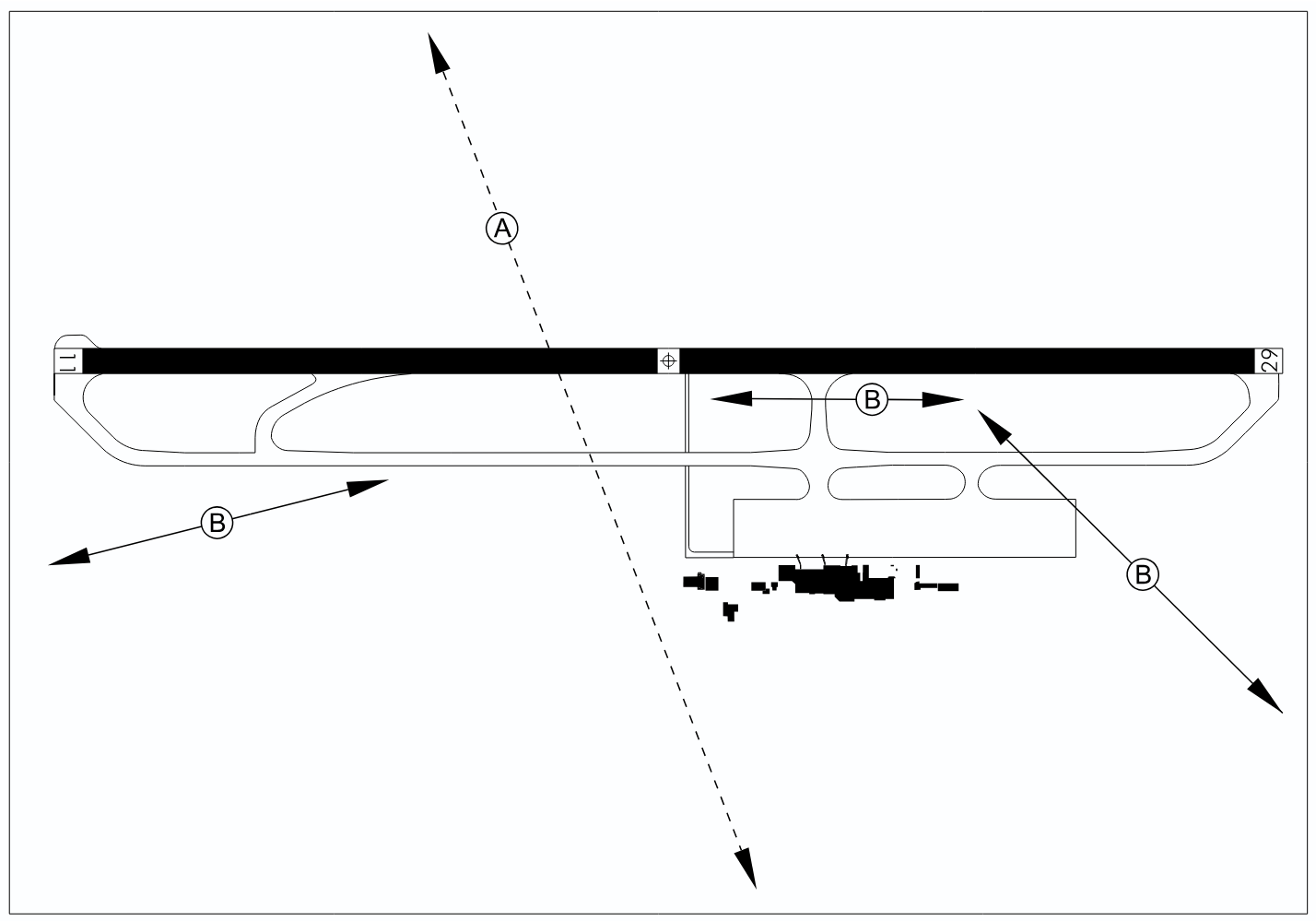
STANDARD TAXIING PROCEDURES
The West configuration (RWY 29) will be preferential, operating according to the appropriate assignment, except when the meteorological conditions establish another runway in use (RWY 11), or with ATC clearance.
Pilots, who request the use of a runway different from the appropriate assignment described above, shall be responsible for the possible delays.
All aircraft, which overshoot the exit taxiways C and D in landing, shall taxi to the runway end and vacate it via TWY T.
Aircraft of category L (light) are excluded from this restriction, subject to ATC clearance.
Take-off from RWY 11 and RWY 29 from the intersection with TWY C is authorized, except during LVC.
Pilots in command of departing aircraft, on reaching the runway-holding position of the runway in use, shall have carried out their previous checks and shall be ready to line up and begin the take-off run immediately after receiving the appropriate clearance. Aircraft which for any reason can not comply with this requirement, will notify this fact to ATC before reaching the holding position.
Regarding allocation of taxiing routes and entrance/exit gate to apron, according to the runway in use and except for operational reasons to the contrary (compliance with CTOT, pilot requesting opposite runway, direction of push-back/towing depending on aircraft taxiing on apron, incidents on apron, etc.), where ATC may coordinate the use of the opposite entrance/exit gate with TOAM/CECOPS, the aircraft assigned PRKG 1, 2 and 3 shall enter and exit the apron by TWY A, and aircraft assigned PRKG 4, 5, 6, 7, 8, 9 and AG shall enter and exit the apron by TWY B.
On the basis of these procedures, the following taxiing routes are established (see AD 2-LEAS ADC):
-
Arrivals to RWY 11:
- RWY 11-ARR01: TWY T, A to PRKG 01, 02, 03.
- RWY 11-ARR02: TWY T, B to PRKG 04, 05, 06, 07, 08, 09, AG.
- RWY 11-ARR03: TWY C, A to PRKG 01, 02, 03.
- RWY 11-ARR04: TWY C, T direction T-1, B to PRKG 04, 05, 06, 07, 08, 09, AG.
- RWY 11-DEP01: from PRKG 01, 02, 03 to TWY A, T to the holding point T-2.
- RWY 11-DEP02: from PRKG 04, 05, 06, 07, 08, 09, AG to TWY B, T to the holding point T-2.
- RWY 11-DEP03: from PRKG 01, 02, 03 to TWY A, T to the holding point C-1.
- RWY 11-DEP04: from PRKG 04, 05, 06, 07, 08, 09, AG. to TWY B, T to the holding point C-1.
- RWY 29-ARR01: TWY T, A to PRKG 01, 02, 03.
- RWY 29-ARR02: TWY D, T, A to PRKG 01, 02, 03.
- RWY 29-ARR03: TWY C, A to PRKG 01, 02, 03.
- RWY 29-ARR04: TWY T, B to PRKG 04, 05, 06, 07, 08, 09, AG.
- RWY 29-ARR05: TWY D, T, B to PRKG 04, 05, 06, 07, 08, 09, AG.
- RWY 29-ARR06: TWY C, T direction T-1, B to PRKG 04, 05, 06, 07, 08, 09, AG.
- RWY 29-DEP01: from PRKG 01, 02, 03 to TWY A, T to holding point T-1.
- RWY 29-DEP02: from PRKG 04, 05, 06, 07, 08, 09, AG to TWY B, T to holding point T-1.
- RWY 29-DEP03: from PRKG 01, 02, 03 to TWY A, T to holding point C-1.
- RWY 29-DEP04: from PRKG 04, 05, 06, 07, 08, 09, AG. to TWY B, T to holding point C-1.
Departures from RWY 11:
Departures from RWY 11 INT C:
Arrivals to RWY 29:
Departures from RWY 29:
Departures from RWY 29 INT C:
Unless otherwise indicated by ATC, in each case the established taxiing route to be used shall correspond to the:
- Runway in use.
- Requirements of take-off length (departure taxiing route).
- Requirements of landing length (arrival taxiing route). Pilots in command of the arriving aircraft will vacate the runway as soon as possible after touchdown in order to make maximum use of runway capacity, to lessen the occupancy time and to avoid missed approach manoeuvres, and without detriment to the safety and normal operation of the aircraft.
- All surface movements of aircraft, towed aircraft, persons and vehicles in the manoeuvring area are subject to prior ATC clearance.
- Assigned stand.
Aircraft shall follow the indications of the“FOLLOW ME” vehicle to be guided to the assigned stand, depending on operational criteria.
Simultaneous operations of entry to/exit from stands will not be carried out in contiguous stands.
Entry-to and exit-from stand manoeuvres shall be carried out at a close to idling power. If a significant power increase is required, pilots shall contact ATC and the manoeuvre will be carried out under the supervision of a signalman.
All movements of aircraft, towed aircraft, persons and vehicles on the apron shall be regulated by the Apron Safety Regulations.
Collision avoidance with other aircraft or obstacles is responsibility of:
- Pilots taxiing in the apron and in the areas not visible from TWR.
- Ground handling agents during exit manoeuvring from the stand.
OPERATION OF TRANSPONDER IN MODE S WHEN THE AIRCRAFT IS ON THE GROUND
To enable cooperation with the Mode-S based Advanced Surveillance System, aircraft operators intending to use Asturias airport shall ensure that their transponders are able to operate in Mode S when the aircraft is on the ground.
Pilots shall:
Select AUTO Mode and the assigned Mode A code. If AUTO mode is not available, select ON (i.e. XPDR) and the assigned Mode A code:
- From the request for towed push-back or taxiing, whichever is earlier.
- After landing, continuously until the aircraft is fully parked on stand.
- When fully parked on stand, select STBY.
Whenever the aircraft is capable of reporting Aircraft Identification (i.e. callsign used in flight), this should also be entered (through the FMS or the Transponder Control Panel) from the moment of request for towed push-back or taxiing, whichever is earlier. Air crew must use the ICAO defined format for entry of the Aircraft Identification (i.e. BAW123, AFR6380, ...).
To ensure that the performance of systems based on SSR frequencies (including airborne TCAS units and SSR radars) is not compromised, TCAS should not be selected before receiving the clearance to line up. It should then be deselected after vacating the runway.
For aircraft taxiing without flight plan, Mode A code 1000 should be selected.
PROCEDURE FOR THE REQUEST OF RESCUE PROTECTION LEVEL AND FIRE FIGHTING CATEGORY ON DEMAND
An operator wishing to operate at Asturias Airport with an aircraft of category ICAO-SSEI higher than 7 shall apply to the airport via email at: operaciones_ovd@aena.es, as far in advance as possible of the scheduled arrival date indicating the aircraft model and the scheduled time of arrival.
OPERATIONAL PROCEDURES FOR AIRCRAFT OF CODE LETTERS D AND E
GENERAL
The risk analyses undertaken have accredited that Asturias Airport offers sufficient guarantees of the level of operational safety required for the operation on the apron of all code letter D aircraft and those code letter E aircraft whose size and characteristics in terms of the physical infrastructure required for their manoeuvres and operations do not exceed those of the model A330-300.
When a code letter D aircraft is moving through the East or West zone of the Movement Area, the movement of more than one aircraft in the same zone shall not be permitted, the dividing line between the East and West zones of the Movement Area being understood to be the centre line perpendicular to the runway which runs along TWY B.
In the case of code letter E aircraft, simultaneous operation on the runway/taxiing is limited to one aircraft at a time.
The operation of aircraft exceeding the aerodrome’s certified design characteristics is permitted during the application of LVP, and the directives described under the local procedure must also be observed.
It is necessary for code letter D or E aircraft to employ oversteering to enter or exit the apron via access gate B.
PARKING
The autonomous PRKG 08A on the apron has been defined for code letter aircraft (D and E), and its use is incompatible with that of the PRKG 07 and 08.
During the manoeuvres of parking and exit, use of the common ESA (Equipment Staging Area) for PRKG 06 and 07 shall be prohibited.
The movement of vehicles via the section of service road adjacent to apron PRKG 08A is not permitted during entry and exit manoeuvres for aircraft exceeding the aerodrome’s certified design characteristics.
GROUND MOVEMENT
The power permitted on the apron is limited, with idling being established for taxiing on the apron.
- Arrivals:
- RWY 29.- Exit runway via TWY T, taxiing via the parallel TWY T, up to apron access gate B, the taxiway via which aircraft shall access the apron towards the stand defined, taxiing via the access taxiway to the stand.
- RWY 11.- Exit runway via TWY T, taxiing via the parallel TWY T, up to apron access gate B, the taxiway via which aircraft shall access the apron towards the stand defined, taxiing via the access taxiway to the stand.
- If a pilot issues a specific request to ATC, guidance can be given with a "FOLLOW ME" vehicle to an arriving aircraft up to the corresponding apron gate. Obligatory guidance from apron access gate B up to aircraft stand.
- Departures:
- RWY 29.- Exit from apron via B, taxiing via TWY T direction T-1 up to THR 29.
- RWY 11.- Exit from apron via B, taxiing via TWY T direction T-2 up to THR 11.
- If a pilot issues a specific request to ATC, guidance can be given with a "FOLLOW ME" vehicle to a departing aircraft, from the parking stand to the requested point of the manoeuvring area. Obligatory guidance from parking stand up to apron access gate B.
NIGHT VISUAL OPERATIONS (VFR-N)
VFR-N flights are permitted.
OPERATIONAL SAFETY REPORTS
Pilots/operator shall report to the airport as soon as possible, any accidents, incidents, occurrences or events which may have a potential operational impact and which they have been involved in or have witnessed.
The aim of these reports is the compilation of information in order to improve operational safety, independently of the mandatory reporting of the occurrence to the appropriate aeronautical authority. Data may be sent in any format, including at least the following information:
- Date and time.
- Site.
- Parties involved (data used to identify vehicles, aircraft...involved).
- Companies implicated.
- Description of the facts.
- Any other data considered relevant (e.g. lighting conditions, weather, phase of the operation such as takeoff / landing / stopover, pavement conditions…).
The contact e-mail address of the airport, for the reception of operational safety reports, is the following: seguridad_operacional_ovd@aena.es
In addition to notifying the airport by means of the indicated system, it is necessary to send at least basic data of the accident, incident, occurrence or event to the air traffic control service provider (ATC).
On the specific instance of safety reports related with the air traffic control service provider (manoeuvring area, flight phases and ATS airspace) these may be sent to the e-mail address: lecm.safety@enaire.es
NOISE ABATEMENT PROCEDURES
No.
FLIGHT PROCEDURES
VISUAL DEPARTURE PROCEDURE FOR IFR FLIGHTS
IFR flights may request a “visual departure” from ATC, on the ground or in the air, under the following conditions:
- Between the beginning of civil twilight in the morning and the end of civil twilight in the evening.
- Weather conditions in the direction of take-off and subsequent initial climb that allow visual flight up to the Minimum Sector Altitude (MSA), which will be provided by ATC.
- In the air, the pilot will propose a heading or a direct route to ATC.
- On the ground, the pilot will propose a heading or point to ATC, or ATC will propose a visual departure subject to the pilot's consent and readback.
- The pilot will be responsible for maintaining the obstacle clearance margin up to the Minimum Sector Altitude (MSA).
FLIGHT PROCEDURES FOR AIRCRAFT WITHOUT RNAV1 OPERATIONAL CLEARANCE
- ARRIVALS PROCEDURE
Aircraft without RNAV1 operational clearance shall notify LECM of this condition on initial callup when entering FIR and they will receive ATC instructions to proceed to AMAKA or XONDA.
- Procedure in case of communications failure during arrival.
Traffic with communications failure shall proceed as follows: maintain last cleared level/altitude, proceed directly to AMAKA or XONDA, and from there, proceed to DVOR/DME VES and join holding. Start descending after one complete holding pattern or after the EAT if received, whichever is later, complete a published IFR approach to the active runway for arrivals, and land within the next 30 minutes.
- DEPARTURES PROCEDURE
- Procedure in case of communications failure during departure.
Aircraft without RNAV1 operational clearance in initial call with LEAS shall will be cleared via conventional SID to proceed to AMAKA or XONDA as directed by ATC.
Traffic with communications failure shall proceed as follows: Head as directly as possible to AMAKA or XONDA climbing to the last cleared altitude/level or until the minimum safe altitude, whichever is higher; maintain that altitude or level for 7 minutes, afterwards, continue climbing according to the updated FPL and join the corresponding ATS route.
LOW VISIBILITY PROCEDURES (LVP)
GENERAL
- RWY 11 is authorized for low visibility take-offs (LVTO).RWY 29, equipped with ILS, is authorized for CAT II/III precision approaches and for low visibility take-offs.
- Low visibility procedures (LVP) shall be applied when any of the following
conditions is met:
- When any transmissometer indicates RVR equal to or lower than 800 m,or visibility equal to or lower than 800 m in the case of failure of all the transmissometers, or
- Cloud ceiling equal to or lower than 300 ft (90 m).
- ATC shall inform pilots by radiotelephone that low visibility procedures are being applied. Any incident notified or detected which might affect the LVP shall be communicated immediately to the aircraft so that they can take appropriate measures.
- ATC shall supply the values of the runway visual range (RVR) directly, as
follows:
- RVR TDZ: Reading corresponding to the touchdown zone.
- RVR MID: Reading from the runway midpoint.
- RVR END: Reading from the runway end.
- When CAT II/III approaches are performed, permission to land shall be conceded before the aircraft is at 2 NM from the TDZ and will only be issued once the sensitive areas (LSA) of the ILS are clear.
- The LVP shall be cancelled when all of the following conditions are met:
- When all the transmissometers indicate RVR above 1000 m, or the same value of visibility if the transmissometers are out of service, and
- Cloud ceiling higher than 500 ft (150 m).
GROUND MOVEMENTS
While LVPs are active, only taxiing of one single mobile unit (aircraft, vehicle or aircraft-vehicle group, vehicle-vehicle under guidance, towing or checking of the manoeuvring area) is permitted in the manoeuvring area, and only one aircraft on the apron is permitted.
While the LVP are active, TWY C shall be closed. Pilots shall proceed to verify the situation of their aircraft at all times, especially at intersections, ensuring that their taxiing takes place under conditions of complete operational safety.
If a pilot issues a specific request to ATC, guidance can be given with a "FOLLOW ME" vehicle on arrival to the corresponding gate on the apron. Obligatory guidance from apron access gate to parking stand.
If a pilot issues a specific request to ATC, guidance can be given with a "FOLLOW ME" vehicle to a departing aircraft from the parking stand to the requested manoeuvring area point.
In the event that an exiting aircraft has to return to the apron, the pilot shall inform ATC and await new taxiing instructions.
With the LVP active, the same requirements and physical restrictions on taxiways and on the apron for aircraft exceeding the aerodrome’s certified design characteristics (see item 20. LOCAL REGULATIONS – OPERATIONAL PROCEDURE FOR AIRCRAFT OF CODE LETTERS D AND E).
Arrivals
On vacating RWY 29, pilots shall notify:
a) ILS sensitive area clear and,
b) Exit taxiway used.
The ILS sensitive area becomes vacant when the centre line lights of the taxiway used change from green and yellow to all green.
On the apron, pilots shall notify:
a) Stand assigned to the aircraft and,
b) Frequency out.
Any aircraft that overshoots TWY D in landing on RWY 29 shall continue taxiing to the runway end to vacate it via TWY T.
Departures
Pilots shall notify the start of taxiing towards TWY A or B (as indicated by ATC).
COMMUNICATIONS FAILURE AND ANOMALOUS SITUATIONS IN THE MANOEUVRING AREA.
Communications failure
In the event that an aircraft operating in the manoeuvring area should experience a communications failure, it shall proceed as follows:
- Departing aircraft: the aircraft shall continue by the assigned route and halt at the ATC clearance limit, taking extreme care, where it shall hold and await the arrival of an assistance vehicle.
- Arriving aircraft: if the aircraft has just landed, it shall hold on vacating the sensitive area and await the arrival of an assistance vehicle.
If the aircraft already has ATC taxiing clearance, it shall continue by the assigned route and halt at the ATC clearance limit, taking extreme care, where it shall hold and await the arrival of an assistance vehicle.
Anomalous situations in the manoeuvring area
- Uncertainty about position in the manoeuvring area.
- Other than as provided for in the following paragraph, if a pilot is in doubt about the position of the aircraft in relation to the manoeuvring area, they must immediately halt the aircraft and report this circumstance to ATC (including the last known position).
- In situations in which a pilot is in doubt about the position of the aircraft in relation to the manoeuvring area, but recognises that the aircraft is on a runway, the pilot shall immediately report this to ATC (including the last known position), and vacate the runway as soon as possible, if they can find an appropriate taxiway nearby, unless ATC should indicate otherwise, and then, halt the aircraft.
- In the event that ATC realises that an aircraft or vehicle has lost its position in the manoeuvring area, or is not sure of its position, the appropriate measures shall be taken immediately to safeguard the operations and help the aircraft or vehicle in question to determine its position.
- Loss of visual contact between mobile elements
- In the event that one aircraft loses visual contact with another, or with a vehicle with which it is maintaining its own separation, ATC shall be informed immediately, and the aircraft halted. ATC shall take the measures that it shall deem fit.
- Breakdown of aircraft
- It shall report the situation to ATC and await the arrival of assistance. Should it find itself on a runway, if possible and unless ATC should indicate otherwise, this shall be vacated.
CAT II/III PRACTICE APPROACHES
- ATC shall not authorize CAT II/III precision practice approaches when the visibility is equal to or less than 1000 m or the cloud ceiling is equal to or less than 500 ft (150 m).
- Those aircraft wishing to carry out this kind of approach shall communicate this to ATC as soon as possible so that the appropriate measures can be taken.
AIRCRAFT ON TAKE-OFF
Take-offs with RVR below 125 m are permitted. It is compulsory to comply with Requirement AMC1 SPA.LVO.100(a) of Regulation (EU) 965/2012 of 5 October 2012 laying down technical requirements and administrative procedures related to air operations, which states in Section (e) that low visibility take-off operations are not permitted when RVR<75m, and therefore no operations shall be conducted under these conditions.
Guided take-offs are permitted on RWY 29 provided the requirements of AMC1 ADR are met. OPS.B.045(a)(1). Aircraft shall notify ATC as soon as possible if they require a guided take-off.
ATS SURVEILLANCE SYSTEM
ATS surveillance systems may be used in the provision of the aerodrome control service, to perform the following functions:
- Flight path monitoring of aircraft on final approach;
- Flight path monitoring of other aircraft in the vicinity of the aerodrome;
- Establishing the separation specified in article 4.6.7.3 of the R.C.A between consecutive departing aircraft;
- Providing navigation assistance to VFR flights.
The provision of functions b) and d) is not guaranteed neither in the ATZ below 500 ft AMSL, nor in the south half of the ATZ below 1600 ft AMSL. Depending on the availability of ATS surveillance systems, the altitude from which the preceding functions (a), b), c) and d)) can be provided may be affected or they may even be suspended, in this case, this will be notified to the aircraft by the available aeronautical information resources.
CONTINUOUS DESCENT OPERATIONS
Depending on traffic situation, and if no need for interrupting the descent is foreseen, aircraft will be cleared to proceed to a standard arrival (STAR), or by means of a “direct to” clearance to an intermediate fix of the STAR, to the IAF, to an intermediate approach fix or to the IF, to the adecuate altitude of the instrumental procedure (IAC), in order to allow a continuous descent operation.
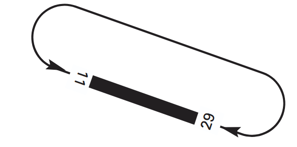
AD TRAFFIC CIRCUIT
ADDITIONAL INFORMATION
High probability of unpredicted fog.
BIRD CONCENTRATION AREAS
Birds presence in and near the airport is probable. Caution is therefore recommended, especially under adverse meteorological conditions and with North wind.
Between approximately 15 June and 15 September, with greatest likelihood during the months of July and August, after days of rain, with stable environmental conditions, high humidity and temperature, and in the absence of rain and wind, there may be occasional concentrations of yellow-legged gulls (Larus michahellis),due to the massive presence of flying ants over therunway at altitudes between 0 and 500 metres (higher when there is low pressure).
FLOWS OF BIRDS
Between the months of October and March, coinciding with the winter and migratory periods, and especially associated with the occurrence of adverse weather (sea storms, cold waves), there may be concentrations of flocks of wading birds (European lapwing, European golden plover) in the airport grounds, with preferential use of paved areas in the Airport Operational Safety Zone.
- Yellow-legged gull (Larus michahellis).
- Small birds of prey, mainly common buzzard (Buteo buteo) and common kestrel (Falco tinnunculus).
AERONAUTICAL CHARTS RELATED TO AN AERODROMECHARTS RELATED TO THE AERODROME
The list of charts related to the aerodrome can be found on the link below:
VISUAL SEGMENT SURFACE (VSS) PENETRATION
Not applicable.