LEBZ AD 2 AERODROME DATA
Aerodrome location indicator and name
LEBZ - BADAJOZ/Talavera La Real
AERODROME GEOGRAPHICAL AND ADMINISTRATIVE DATA
ARP |
385329N 0064917W. See AD 2-LEBZ ADC. |
|
Distance and direction from the city |
13 km E. |
|
Elevation |
185 m / 608 ft. |
|
Geoid undulation |
54.17 m ± 0.05 (1). |
|
Reference temperature |
35°C. |
|
Low average temperature |
8ºC. |
|
Magnetic variation |
1º W (2020). |
|
Annual change |
8.4´E. |
|
AD administration |
CIV: Aena. |
|
Address |
Ctra. Badajoz - Balboa s/n. - 06195 Badajoz. |
|
TEL |
CIV: +34-924 210 406 |
|
FAX |
CIV: +34-924 210 453 |
|
AFTN |
LEBZ |
|
CIV: cecoabjz@aena.es |
||
Approved traffic |
IFR/VFR. |
|
Remarks |
(1) For all AD points. |
OPERATIONAL HOURS
Airport |
CIV: V: 0630-1815; I: 0730-1915. (1)
Other hours according to training periods. |
|
Customs and Immigration |
HR AD. |
|
Health and Sanitation |
No. |
|
AIS/ARO/OPV |
HR AD. |
|
MET briefing |
HR AD. |
|
ATS |
HR AD. |
|
Fuelling |
CIV: V: SUN-FRI 0600-1300; SAT 0600-1000 |
|
Handling |
HR AD. |
|
Security |
H24. |
|
De-icing |
Ask handling agent IBERIA. |
|
Remarks |
(1) Extension of civil operating hours and foreign State aircraft, see item 20.
|
HANDLING SERVICES AND FACILITIES
Cargo facilities |
MIL: Up to 72000 Kg. |
|
Fuel types |
CIV: JET A-1, 100LL. |
|
Oil types |
CIV: NIL. |
|
Refuelling capacity |
CIV:
MIL: |
|
De-Icing facilities |
No. |
|
Hangar space |
No. |
|
Repair facilities |
No. |
|
Remarks |
GPU: AC (up to 45 KVA) and DC (up to 1500 A) unit.
AVIAPARTNER AVIAVIP SPAIN
|
PASSENGER FACILITIES
Hotels |
MIL: Yes. |
|
Restaurant |
MIL: Yes. |
|
Transportation |
CIV: Taxis and hire cars. |
|
Medical facilities |
MIL: First aid and ambulance. |
|
Bank/Post Office |
No. |
|
Tourist information |
No. |
|
Remarks |
None. |
Rescue and firefighting services
Fire category |
CIV: 7. |
|
Rescue equipment |
MIL: In accordance with the fire category published. |
|
Removal of disabled aircraft |
Yes, only by dragging. |
|
Remarks |
Service provided by the Ejército del Aire y del Espacio. |
Runway surface condition assessment and reporting, and snow plan
Equipment |
MIL: Heavy crane of 72000 Kg. |
|
Priority |
RWY, TWY and apron. |
|
Remarks |
Service provided by the Ejército del Aire y del Espacio. |
Aprons, taxiways and check locations/positions data
Apron |
Surface: CIV: Asphaltic concrete. MIL: Hydraulic concrete. |
|
Taxiways |
Width: 22 m.
|
|
Check locations |
Altimeter: Civil apron: 180 m / 591 ft. |
|
Remarks |
None. |
Surface movement guidance and control system and markings
Taxiing guidance system |
Runway-holding positions, boards and stands. |
|
RWY markings |
Designators, threshold, centre line, aiming point, touchdown zone and side stripe. |
|
TWY markings |
Centre line and side stripe. |
|
Remarks |
None. |
AERODROME OBSTACLES
IN APPROACH AND TAKE-OFF AREAS
RWY/Area |
Obstacle |
Coordinates |
|---|---|---|
31/APCH |
Tower 272 m / 892 ft |
127°/ 9380 m.FM THR 31
|
Remarks: See AD 2-LEBZ AOC. |
||
IN CIRCLING AREA AND AD
Obstacle |
Coordinates |
|
|---|---|---|
Antenna 288.04 m / 945.01 ft |
385208.9N 0064918.7W |
|
Antenna 179 m / 586 ft |
385352.6N 0064950.3W |
|
Hangar 190 m / 623 ft |
385310.9N 0064926.9W |
|
Floodlighting pole 202 m / 663 ft |
385302.3N 0064902.1W |
|
ABN 209 m / 687 ft |
385254.6N 0064900.8W |
|
Antenna 199 m / 652 ft |
385259.5N 0064849.9W |
|
Antenna 203 m / 664 ft |
385310.8N 0064910.1W |
|
Antenna 203 m / 664 f |
385309.0N 0064907.1W |
|
Remarks: See AD 2-LEBZ AOC. |
||
Meteorological information provided
MET office |
CIV/MIL: Talavera La Real OMD. |
|
HR |
HR AD. |
|
METAR |
Half-hourly. |
|
TAF |
H24. |
|
TREND |
No. |
|
Landing forecasts |
No. |
|
Briefing |
Telephone and fax. |
|
Flight documentation/Language |
Charts and plain language/Spanish. |
|
Charts |
Significant and forecast at altitude (wind and temperature) maps. |
|
Supplementary equipment |
Cloud, lighting and radar information image display. |
|
ATS unit served |
AIS, TWR, OPV. |
|
Additional information |
Sevilla OMAe (LESV): H24
Talavera La Real OMD: HR AD
|
|
Remarks |
Aerodrome climatological summary available. Aerodrome warnings available. |
RUNWAY PHYSICAL CHARACTERISTICS
RWY |
Direction |
DIM (m) |
THR PSN |
THR ELEV |
SWY (m) |
CWY (m) |
Strip (m) |
OFZ |
RESA (m) |
RWY/SWY SFC |
|---|---|---|---|---|---|---|---|---|---|---|
13 |
125.62° GEO |
2852 x 60 |
385355.51N 0065004.62W |
THR: 176 m / 578 ft |
300 x 60 |
300 x 150 |
No |
No |
No |
RWY: Asphaltic concrete |
31 |
305.63° GEO |
2852 x 60 |
385301.64N 0064828.42W |
THR: 185.2 m / 608 ft |
300 x 60 |
300 x 150 |
No |
No |
No |
RWY: Asphaltic concrete |
Remarks: Talavera La Real Air Base Airfield Category 4DNone. |
||||||||||
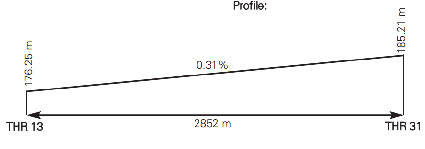
Profile
DECLARED DISTANCES
RWY |
TORA (m) |
TODA (m) |
ASDA (m) |
LDA (m) |
|---|---|---|---|---|
13 |
2852 |
3152 |
3152 |
2852 |
31 |
2852 |
3152 |
3152 |
2852 |
Remarks: None. |
||||
APPROACH AND RUNWAY LIGHTING
Runway |
13 |
|
Approach |
Simple, 420 m. Threshold identification lights. (1) |
|
VASIS |
2.5º. Right wing U/S. |
|
Threshold |
Green. |
|
Touchdown zone |
No. |
|
Runway centre line |
No. |
|
Runway edge |
2852 m white. Distance between lights: 55 m. (1) |
|
Runway end |
Red. |
|
Stopway |
No. |
|
Remarks |
(1) Adjustable light intensity. |
Runway |
31 |
|
Approach |
Simple, 420 m. Threshold identification lights. (1) |
|
VASIS |
2.5°. Left wing U/S. |
|
Threshold |
Green. |
|
Touchdown zone |
No. |
|
Runway centre line |
No. |
|
Runway edge |
2852 m white. Distance between lights: 55 m. (1) |
|
Runway end |
Red. |
|
Stopway |
No. |
|
Remarks |
(1) Adjustable light intensity. |
OTHER LIGHTING, SECONDARY POWER SUPPLY
ABN |
ALTN FLG W EV 8 s. |
|
WDI |
1 near THR 31 LGTD. |
|
TWY lighting |
Edge EXC C-3 and C-4. |
|
Apron lighting |
CIV: 6 floodlighting towers. MIL: 4 floodlighting towers. |
|
Secondary power supply |
1 engine generator set that provides a switch-over time for CAT I according to Annex 14. |
|
Remarks |
None. |
HELICOPTER LANDING AREA
Position |
Intersection of TWY C-1-2 and T-3. |
|
Elevation |
Information not available. |
|
Dimensions, surface, maximum weight, marking |
Information not available. |
|
Direction |
Information not available. |
|
Declared distances |
Information not available. |
|
Lighting |
Information not available. |
|
Remarks |
None. |
Air traffic services airspace
Designation |
CTR TALAVERA.
|
|
|
Lateral limits |
383939.3675N 0071552.6301W, circular sector of 25 NM radius centred on 385329N 0064917W up to 391754.4652N 0064222.1199W,390745.2233N 0070835.5513W, following the Portuguese boundary up 383939.3675N 0071552.6301W. |
Vertical limits Airspace class |
FL 195-FL240... C. SFC-FL195... D. |
|
Unit / Language |
TALAVERA APP ES/EN. |
|
Transition altitude |
- |
|
Hours of applicability |
- |
Designation |
ATZ BADAJOZ. |
|
|
Lateral limits |
Circle radius 8 km centred on ARP (1). |
Vertical limits Airspace class |
SFC-3000 ft HGT (2)... D. |
|
Unit / Language |
BADAJOZ TWR |
|
Transition altitude |
1850 m/6000 ft. |
|
|
Remarks |
(1) Or the ground visibility, whichever is lower. |
Hours of applicability |
- |
Air traffic services communication facilities
Service |
Call sign |
FREQ |
HR |
Remarks |
|---|---|---|---|---|
APP |
Talavera APP |
120.555 C |
HR AD |
CIV/MIL |
TWR |
Badajoz TWR |
121.500 MHz |
HR AD |
EMERG |
Badajoz GMC |
130.155 C |
HR AD |
GMC CIV/MIL |
Radio navigation and landing aids
Facility (VAR) |
ID |
FREQ |
HR |
Coordinates |
DME ELEV |
Remarks |
|---|---|---|---|---|---|---|
DVOR (1º W) |
VBZ |
116.800 MHz |
H24 |
385323.5N 0064856.8W |
— |
— |
DME |
VBZ |
CH 115X |
H24 |
385323.5N 0064856.8W |
180 m |
— |
LOC 31 ILS CAT I (1º W) |
ITL |
110.500 MHz |
H24 |
385401.7N 0065015.6W |
— |
COV 25 NM. |
GP 31 |
— |
329.600 MHz |
H24 |
385310.4N 0064835.7W |
— |
3°; RDH 16 m; at 300.7 m FM THR 31 & 117.4 m RCL to the right in the direction of APCH. |
ILS/DME 31 |
ITL |
CH 42X |
H24 |
385310.4N 0064835.7W |
192 m |
REF DME THR 31 |
TACAN (1º W) |
TBC |
CH 25X |
H24 |
385329.8N 0064907.2W |
— |
Possible signal loss BLW 6000 ft BTN 16 NM & 25 NM in the sector BTN 10º & 30º. |
Local aerodrome regulations
The request for extension of civil operating hours shall be addressed by companies or air operators to the AENA delegate at the Talavera La Real Air Base (Badajoz), at least four days in advance.
In the case of scheduled lines operating from or to Badajoz that suffer delays due to unforeseen causes not attributable to the operating company, they may submit the request for extension of operating hours at least two hours in advance.
Foreign state/military aircraft: it is mandatory to request PPR at least 72 hours in advance to one of the following addresses:
-
AFTN : LEBZ
-
FAX : +34-924 209 815
In case of transport of dangerous goods, it shall be carried out at least two working days in advance. As a general rule, PPR request will not be accepted during the following hours:
-
V: FM FRI 1200 TO MON 0630.
-
I: FM FRI 1330 TO MON 0730.
During the period of military activity, no civil aircraft (IFR/VFR) will be authorized to conduct approach or take-off and landing practices.
Only take-off and final landing with an approved flight plan from or to LEBZ AD will be authorized. These operations may experience delays depending on the military activity in progress at that time.
Engine testing not available on civil apron.
NOISE ABATEMENT PROCEDURES
No.
FLIGHT PROCEDURES
VFR aircraft with destination Badajoz will establish radio contact before entering the CTR.
LOW VISIBILITY PROCEDURES (LVP)
Low Visibility Procedures (LVP) are not available at Badajoz airport.
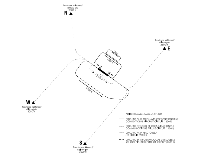
AD TRAFFIC CIRCUIT
ADDITIONAL INFORMATION
ARRESTING SYSTEMS
-
Nomenclature: LEBZ-01-R-U.
-
Type: NET BARRIER UNIDIRECTIONAL.
-
Location: RWY 13 THR+2862 m/9390 ft.
-
Readiness status: Permanently available, under pilot request.
-
Nomenclature: LEBZ-02-R-U.
-
Type: NET BARRIER UNIDIRECTIONAL.
-
Location: RWY 31 THR+2832 m/9291 ft.
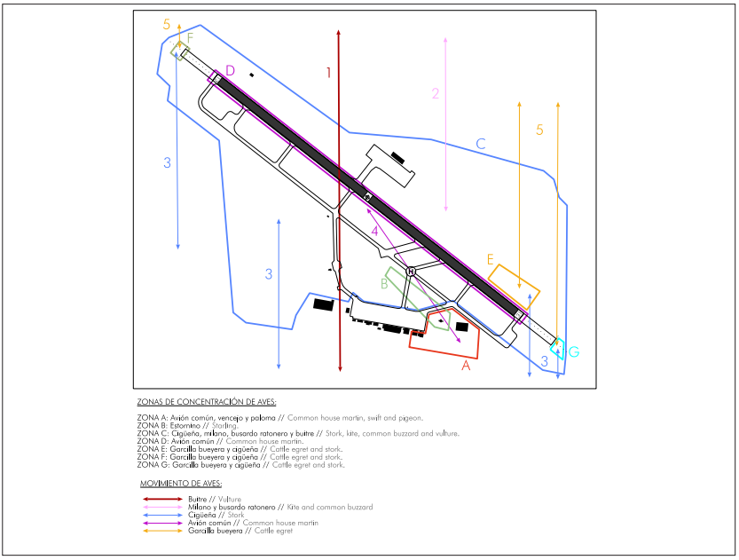
BIRD CONCENTRATION AREAS
Zone A: The common house martin and swift are the predominant species, and they remain from February to September. The presence of pigeons is occasional.
Zone B: There is not much presence of starlings, but they are found concentrated between the Control Tower and the antennas between TWY C-1-2 and C-1-3.
Zone C: Kites and common buzzards are found in the zone all year, although their presence increases around harvest time (May, June). Storks are found in the zone practically year round, although they are more common from Spring to Autumn, and particularly around harvest time. Vultures are also present in this zone around harvest time.
Zone D: In the months of June, July and August, common house martins occasionally roost in large numbers on the runway if temperatures are low.
Zones E, F and G: During clearing works in the ILS critical areas (localizer and glide path), and the zone between the stopway of RWY 13 and the air base fence, there is a large concentration of cattle egrets, with storks in smaller numbers.
BIRD MOVEMENTS
Flow 1: During spring, Summer and Autumn, vultures may be seen in transit from the North to feeding zones to the South. Their number rises during the hotter months as they make use of the thermals, and at harvest time they may even feed in zone C.
Flow 2: The kite and common buzzard fly from the North to zone C for feeding, especially around harvest time.
Flow 3: The storks go to zones C, E and F from the South, for feeding.
Flow 4: During the months of June, July and August, and if temperatures fall, the common house martin occasionally moves to the runway (zone D) at dusk to roost, returning to zone A by day when temperatures rise.
Flow 5: The cattle egret moves from the north to zones E and F for feeding.
Aeronautical charts related to an aerodrome
The list of charts related to the aerodrome can be found on the link below:
VISUAL SEGMENT SURFACE (VSS) PENETRATION
Not applicable.