LECO AD 2 AERODROME DATA
AERODROME LOCATION INDICATOR - NAME
LECO - A CORUÑA
AERODROME GEOGRAPHICAL AND ADMINISTRATIVE DATA
ARP |
431807N 0082238W. See AD 2-LECO ADC. |
|
Distance and direction from the city |
8 km S. |
|
Elevation |
101 m / 330 ft. |
|
Geoid undulation |
54.60 m ± 0.05 m (1). |
|
Reference temperature |
24°C. |
|
Low average temperature |
8ºC. |
|
Magnetic variation |
2°W (2020). |
|
Annual change |
9.2'E. |
|
AD administration |
Aena. |
|
Address |
Aeropuerto de A Coruña, Apdo. 10; 15174 Rutis-Vilaboa (A Coruña). |
|
TEL |
+34-981 187 201/210/209. |
|
AFTN |
LECO |
|
Approved traffic |
IFR/VFR (2). |
|
Remarks |
(1) For all AD points. (2) Due to apron capacity: All operations of General Aviation, Business, Air taxis, Training flights, State aircraft except for special reasons, must comply with the following procedure:
IFR and VFR flights without prior clearance will be rejected. |
OPERATIONAL HOURS
Airport |
V: 0430-2230; I: 0530-2330. PS 1 HR PPR. |
|
Customs and Immigration |
HR AD. |
|
Health and Sanitation |
No. |
|
AIS/ARO |
H24. (1) |
|
MET briefing |
FM 1 HR BFR HR AD TO 30 MIN AFT HR AD. |
|
ATS |
HR AD. |
|
Fuelling |
HR AD. |
|
Handling |
HR AD. |
|
Security |
HR AD. |
|
De-icing |
HR AD. |
|
Remarks |
(1) Centralised ARO office geographical area 1.
Centralised AIO Office - International NOTAM Office.
|
HANDLING SERVICES AND FACILITIES
Cargo facilities |
Fork lift 1500 kg. Conveyor belt 1000 kg. |
|
Fuel types |
JET A-1, 100LL. |
|
Oil types |
AEROSHELL W100. |
|
Refuelling |
JET A-1:
100LL:
|
|
De-Icing facilities |
Aircraft shall perform de-icing on their own stand, with hot water and glycol units. Service provided by handling agent. |
|
Hangar space |
No. |
|
Repair facilities |
No. |
|
Remarks |
It is compulsory to hire ground handling services for all operations, including non-commercial ones. During arrival operations, passengers and cabin crew shall wait on board the aircraft for ground handling staff to arrive. At the very least, a category 5 apron, aircraft assistance, must be hired. Additionally, whenever there are passengers whose origin or destination is a NON-Schengen airport, category 2, Passenger assistance, must be hired. Exemptions: State, hospital, SAR, military, humanitarian and fire-fighting flights. Handling agents:
|
PASSENGER FACILITIES
Hotels |
No. |
|
Restaurant |
Yes. |
|
Transportation |
Buses, taxis and hire cars. |
|
Medical facilities |
No. |
|
Bank/Post Office |
Cash dispensers / No. |
|
Tourist information |
Yes. |
|
Remarks |
None. |
RESCUE AND FIRE FIGHTING SERVICE
Fire category |
7. (1) |
|
Rescue equipment |
In accordance with the fire category published. |
|
Removal of disabled aircraft |
Available subject to signed declaration of disablement by the aircraft operator so that they may proceed to remove it with their own means, and releasing the airport manager from liability. (2) Capacities of available equipment:
|
|
Remarks |
(1) Response time is less than 3 min, with an operational objetive less than 2 min. (2) Responsability for the coordination of operations in the removal of disabled aircraft: Airport Coordination Office. Contact data can be found in item 2. |
RUNWAY SURFACE CONDITION ASSESSMENT AND REPORTING AND SNOW PLAN
Types of clearing equipment |
Not applicable. |
|
Clearance priorities |
Not applicable. |
|
Use of material for movement area surface treatment |
UREA. |
|
Specially prepared winter runways |
Not applicable. |
|
Remarks |
Runway surface condition assessment and reporting in accordance with the Global Reporting Format (GRF) methodology described in AD 1.2.2. Aerodrome in service during all seasons of the year. |
MOVEMENT AREA DETAILS
Apron |
Surface: Concrete. Strength: Ramp 0: PCN 95/R/D/W/T. Ramp 1: PCN 90/R/C/W/T. |
|
Taxiways |
Width: 23 m. Surface: Asphalt. Strength: TWY N: PCN 47/F/B/W/T. TWY S: PCN 97/F/A/W/T. |
|
Air taxiway |
Width: TWY NA: 6.2 m. Surface: Graded aggregate. Strength: INFO NO AVBL. |
|
Check locations |
Altimeter: Apron ELEV 93 m/305 ft. VOR: No. INS: See AD 2-LECO PDC. |
|
Remarks |
None. |
TAXIING GUIDANCE SYSTEM AND MARKINGS
Taxiing guidance system |
Boards, runway-holding positions, stop bars, runway guard lights and stands. |
|
RWY markings |
Designators, threshold, centre line, side stripe, aiming point and touchdown zone. |
|
TWY markings |
Edge, centre line and enhanced centre line. |
|
Remarks |
None. |
AERODROME OBSTACLES
Obstacles which penetrate Approach, Take-Off Climb, Conical, Inner Horizontal, Transitional, Inner Transitional and Balked Landing Surfaces established in ICAO Annex 14; and the areas 2A and 3 established in ICAO Annex 15. Those penetrating these surfaces are identified in the CSV file as “Relevante_Relevant = Si/Yes”. |
See Item 10 and Data Sets section. |
|
Remarks |
See AD 2-LECO AOC. |
The following aerodrome obstacles with LED lighting do not have infrared emission (see the digital data of item 10).
Localizer path - LECO-OBS-00300-000-2022 |
Windsock at THR 03 - LECO-OBS-00563-000-2022 |
Central windsock - LECO-OBS-00315-000-2022 |
Windsock at THR 21 - LECO-OBS-00466-000-2022 |
Hangar workshops - LECO-OBS-00627-001-2022 |
SEI - LECO-OBS-00631-001-2022 |
Control tower - LECO-OBS-00556-004-2022 |
Lighting tower 1- LECO-OBS-0478-000-2022 |
Lighting tower 2 - LECO-OBS-00632-000-2022 |
Lighting tower 3 - LECO-OBS-00635-000-2022 |
Lighting tower 4 - LECO-OBS-00649-000-2022 |
Lighting tower 5 - LECO-OBS-00654-000-2022 |
Jet blast deflector 1 - LECO-OBS-00652-001-2022 |
Jet blast deflector 2 - LECO-OBS-00653-001-2022 |
Jet blast deflector 3 - LECO-OBS-01680-001-2022 |
METEOROLOGICAL SERVICE PROVIDED
MET office |
A Coruña EMAe. |
|
HR |
FM 1 HR BFR HR AD TO 30 MIN AFT HR AD. Outside this schedule, a half-hourly METAR AUTO will be issued. |
|
METAR |
Half-hourly. |
|
TAF |
24 HR. |
|
TREND |
Yes. |
|
Briefing |
In person and by telephone. |
|
Flight documentation/Language |
Charts and plain language / Spanish. |
|
Charts |
Significant forecasted and wind and temperature in altitude maps. |
|
Supplementary equipment |
Clouds and lightning image and radar information display. |
|
ATS unit served |
TWR. |
|
Additional information |
Santander OMAe (LESD): H24; TEL: +34-942 392 464. A Coruña EMAe: HR AD; TEL: +34-981 134 647. |
|
Remarks |
Aerodrome climatological summary available. Aerodrome warnings available. There is a meteorological station sited in 4322N 00826W, near the AD area, this station accomplishes observation balloons launched daily from 1115 to 1200, and from 2315 to 0000. See ENR 5.3 Aerodrome MET guide avaliable. |
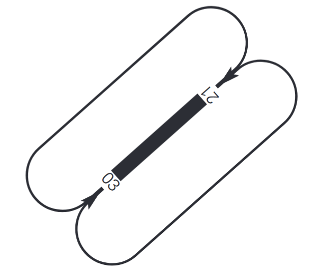
RUNWAY PHYSICAL CHARACTERISTICS
RWY |
Direction |
DIM (m) |
THR PSN |
THR ELEV TDZ ELEV |
SWY (m) |
CWY (m) |
Strip (m) |
OFZ |
RESA (m) |
RWY/SWY SFC PCN |
|---|---|---|---|---|---|---|---|---|---|---|
03 |
030.94°GEO 033º MAG |
2188 x 45 |
431730.13N 0082308.72W |
THR: 100m/ 329 ft TDZ: 100.6m/ 330 ft |
No |
300 x 150 |
2308 x 150 (5) |
No |
240 x 150 (1) |
RWY: ASPH PCN 72/F/B/W/T (7) SWY: No |
21 (2) (3) |
210.95°GEO 213°MAG |
2188 x 45 (4) |
431830.94N 0082218.81W |
THR: 82.8m/ 272 ft TDZ: 88.1m/ 289 ft |
No |
300 x 150 |
2248 x 150 (5) (6) |
Yes |
240 x 150 |
RWY: ASPH PCN 72/F/B/W/T (7) SWY: No |
Remarks: (1) The last 90 m, RESA is 90 x 90. (2) Coordinates start only for take-off RWY 21: 431835.08N 0082215.41W. (3) End of RWY 21 coordinates: 431734.28 0082305.19W. (4) The last 150 m are not usable for landings. (5) Runway strip width requirement waived: runway strip is 150 m wide instead of 300 m. (6) The strip for landings in RWY 21 is 2158 x 150 and begins 60 m before THR 21. (7) Intermediate turning pad: PCN 68/F/C/W/T. |
||||||||||
Profile:
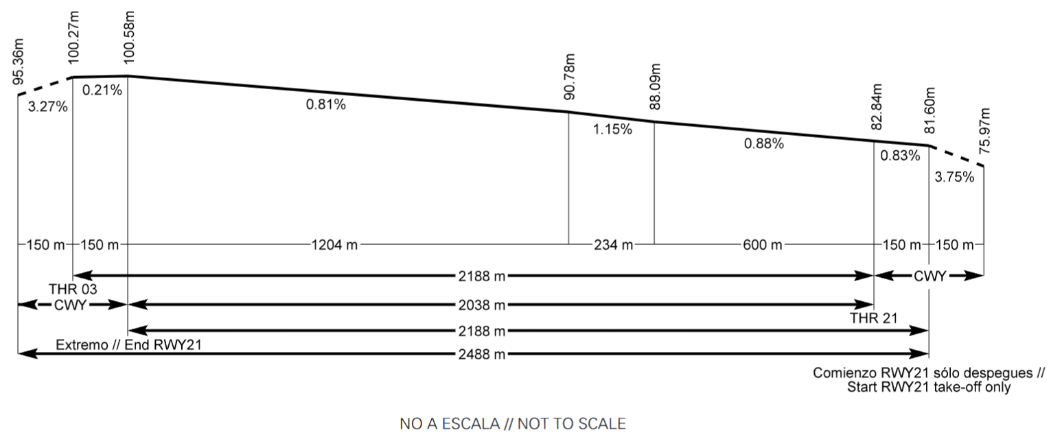
DECLARED DISTANCES
RWY |
TORA (m) |
TODA (m) |
ASDA (m) |
LDA (m) |
|---|---|---|---|---|
03 |
2188 |
2488 |
2188 |
2188 |
21 |
2188 (1) |
2488 (1) |
2188 (1) |
2038 |
21 INT N |
1192 |
1492 |
1192 |
NU |
Remarks: (1) Includes 150 m before THR 21. |
||||
APPROACH AND RUNWAY LIGHTING
Runway |
03 |
|
Approach |
Threshold identification lights. (1) |
|
PAPI (MEHT) |
3.42° (16.40 m/54 ft). |
|
Threshold |
Green, with wing bars. |
|
Touchdown zone |
No. |
|
Runway centre line |
2188 m: 1288 m white + 600 m red and white + 300 m red. (1) Distance between lights: 15 m. |
|
Runway edge |
2188 m: 1588 m white + 600 m yellow. (1) Distance between lights: 50 m. |
|
Runway end |
Red. Distance between lights: 2.80 m. |
|
Stopway |
No. |
|
Remarks |
(1) Adjustable intensity LED lights. |
Runway |
21 |
|
Approach |
Precision CAT II/III, 420 m. Runway lead-in lighting system, 210 m. (1) |
|
PAPI (MEHT) |
3° (16.37 m/54 ft). |
|
Threshold |
Green, with wing bars. |
|
Touchdown zone |
900 m white. |
|
Runway centre line |
2188 m: 1288 m white + 600 m red and white + 300 m red. (1) Distance between lights: 15 m. |
|
Runway edge |
2188 m: 150 m red + 1438 m white + 600 m yellow. (1) Distance between lights: 50 m. |
|
Runway end |
Red. Distance between lights: 2.80 m. |
|
Stopway |
No. |
|
Remarks |
(1) Adjustable intensity LED lights. |
OTHER LIGHTING, SECONDARY POWER SUPPLY
ABN/IBN |
No. |
|
WDI |
1 near THR 03, 1 near THR 21, 1 near ARP. LGTD. |
|
TWY lighting |
Centre line and edge. (1) |
|
Apron lighting |
Floodlighting poles. |
|
Secondary power supply |
Static uninterruptible power supply that provides a maximum switch-over (light) time of 1 second for the approach, runway and taxiways, marking and engine generators that provide a maximum switch-over (light) time of 15 seconds for the apron lighting, according to Annex 14. |
|
Remarks |
(1) Reflective markers in edge. |
HELICOPTER LANDING AREA
Position |
Geoid undulation: See item 2. FATO: RWY 03/21. Coordinates THR 03 and THR 21, see item 12. Taxiing: TLOF same as RWY 03/21. Coordinates 431807N 0082238W (same as ARP). |
|
Elevation |
FATO: RWY 03/21. Elevation THR 03 and THR 21, see item 12. Taxiing: TLOF same as RWY 03/21. Elevation 101 m (same as THR 03). |
|
Dimensions, surface, maximum weight, marking |
No. |
|
Direction |
No. |
|
Declared distances |
No. |
|
Lighthing |
No. |
|
Remarks |
None. |
ATS AIRSPACE
Designation |
CTR A CORUÑA. |
|
Lateral limits |
431929N 0080726W; 430823N 0081635W; 431542N 0083528W; 432732N 0082547W; 431929N 0080726W. |
|
Vertical limits |
SFC - 3000 ft AMSL. |
|
Airspace class |
D. |
|
Unit Language |
A CORUÑA TWR. ES/EN. |
|
Transition altitude |
1850 m / 6000 ft. |
|
Remarks |
Out of the hours of operation, the volume of airspace associated to CTR A CORUÑA Will be class G, with flight information service provided by SANTIAGO TACC (see SANTIAGO APP frequency in item 18). |
ATS COMMUNICATION FACILITIES
Service |
Call sign |
FREQ |
HR |
Remarks |
|---|---|---|---|---|
APP |
Santiago APP |
120.200 MHz |
H24 |
APP/H |
TWR |
A Coruña TWR |
118.305 C |
HR AD |
|
121.500 MHz |
HR AD |
EMERG |
||
121.705 C |
HR AD |
GMC |
||
VDF |
A Coruña gonio |
118.300 MHz |
HR AD |
|
121.500 MHz |
HR AD |
|
||
ATIS |
A Coruña Information |
129.005 C |
HR AD |
|
D-ATIS |
A Coruña Information |
NIL |
HR AD |
Provision of ATIS information via data link. |
RADIO NAVIGATION & LANDING FACILITIES
Facility (VAR) |
ID |
FREQ |
HR |
Coordinates |
DME ELEV |
Remarks |
|---|---|---|---|---|---|---|
DVOR (2º W) |
LRA |
115.100 MHz |
H24 |
432346.2N 0081824.5W |
COV at 10 NM possible oscillations of ± 2º BTN R-300/R-360 at 4500 ft AMSL or BLW. COV at 25 NM AVBL BTN:
|
|
DME |
LRA |
CH 98X |
H24 |
432346.2N 0081825.2W |
120 m |
COV at 25 NM AVBL BTN:
|
NDB (2º W) |
COA |
401.000 kHz |
H24 |
432156.1N 0081942.3W |
031° MAG/7243 m FM THR 21. |
|
L (2º W) |
C |
410.000 kHz |
H24 |
431925.2N 0082139.0W |
030° MAG/1898 m FM THR 21. |
|
LOC 21 |
LCO |
109.900 MHz |
H24 |
431725.8N 0082312.3W |
213° MAG/156 m FM THR 03. COV 17 NM AVBL BTN ± 35º at 2800 ft AMSL or ABV. |
|
ILS CAT II (2º W) |
||||||
GP 21 |
333.800 MHz |
H24 |
431824.5N 0082227.7W |
3°; RDH 16.50 m; at 271.82 m FM THR 21 & 69.84 m FM RCL to the right in the direction of APCH. Full fly-up indications may not be received BLW GP and beyond 6º Right FM RCL. |
||
ILS/DME 21 |
LCO |
CH 36X |
H24 |
431824.5N 0082227.7W |
90 m |
REF DME THR 21. |
LOCAL REGULATIONS
A Coruña airport has topographic and climatological features that require specific procedures and operating methods. Crews should familiarize themselves with these before coming to LECO. This provision is particularly important for pilots not familiar with this airport.
Landing aircraft surpassing the taxiway exits to the apron must continue taxiing straight ahead in order to make the turn at the runway end. Nevertheless, the possibility to vacate the runway making the turn on the intermediate turning pad is allowed.
AUTHORISED TAKE-OFFS FROM RUNWAY INTERSECTION
-
Intersection of TWY N with RWY 21. There are no constraints for use.
STANDARD TAXIING PROCEDURES
START-UP OF ENGINES/TURBINES
The handling company or the airline must check that both pedestrians and vehicles comply with the minimum engine separation requirements regulated by the Apron Safety Guidelines, before aircraft start-up their engines.
In order to avoid FPL being cancelled automatically, the EOBT must be updated.
-
Pilots will request clearance to start-up engines/turbines on the appropriate A Coruña TWR frequency.
When this clearance is requested, the aircraft must be ready to start up immediately or in a good condition to do so within a maximum of 5 minutes.
-
Upon requesting engine start-up clearance from ATC, pilots will report the complete aircraft designator and the parking position occupied.
-
The start-up request should be carried out, considering that aircraft should be ready to leave the stand, in line with the following criteria:
-
Aircraft with CTOT assigned: 10 minutes before CTOT when it is parked at a towed push-back stand, or 5 minutes before CTOT for the rest of stands.
-
Aircraft without CTOT assigned: if it requires towed push-back: maximum 5 minutes after its EOBT. In all other cases, maximum 10 minutes after its EOBT.
-
-
Depending on the air traffic situation, any ATC clearance requested later than the periods established in these criteria may be rejected.
GROUND MOVEMENT
It is forbidden to cross the taxiways for accessing the stands in the apron on foot.
General Aviation passengers will preferably use the GATE C.
The TWR ATC personnel will be responsible for establishing the taxi route for accessing the runway in use for departure operations, this possibly being TWY N or TWY S.
For entry operations in stands, aircraft will wait for the arrival of a “FOLLOW ME” vehicle on the TWY N and S holding position exits, or in its absence, the Coordination Office shall notify ATC of the stand assigned and that no guidance is available. ATC shall notify the aircraft of the stand so it may proceed following the apron markings.
Autonomous exit manoeuvres will be carried out using the minimum idle power. Aircraft will be responsible for carrying out the stand exit manoeuvre, observing the guidance marking and leaving the apron via the TWY specified by ATC.
-
All movements of aircraft, towed aircraft, personnel and vehicles on the manoeuvring area are subject to previous ATC clearance.
-
TWR is responsible for issuing clearances and instructions for towed pushback and the taxiing of aircraft.
-
All movements of aircraft in the apron are subject to previous ATC clearance.
-
Avoiding collisions with other aircraft and obstacles is responsibility of:
-
Handling companies during the push-back manoeuvre.
-
Pilots, during taxiing in the apron.
-
ATC, in the manoeuvring area.
-
PUSH-BACK MANOEUVRING AND TAXIING
-
Aircraft must be ready for towed push-back or taxiing within the next 5 minutes after the approved start-up time; otherwise pilots will contact ATC. No longer than 3 minutes should pass between the push-back manoeuvre being finished and the beginning of taxiing.
-
Push-back manoeuvres shall be completed as follows, unless A Coruña TWR advises differently:
-
RWY 21 in service: nosing north, for taxiing to TWY N.
-
RWY 03 in service: nosing south, for taxiing to TWY S.
-
180º turns in the TWY apron not be authorised.
NIGHT VISUAL OPERATIONS (VFR-N)
Night visual operations are cleared.
ENERGY SAVING POLICY, SHUTDOWN OF SURFACE AERONAUTICAL LIGHTS
A Coruña airport in operating hours and when there is no probability that regular or emergency operations are carried out, applies energy saving procedures that involves the shutdown of the runway centre line and edge lights, and PAPI.
RESTRICTIONS TO STANDS
-
Access to PRKG 6 or H3 is limited to taxiing by aircraft MAX SPAN 18.
-
Access to the flying school hangar is limited to taxiing by aircraft MAX SPAN 11.
-
Aircraft to access PRKG 2, must follow the instructions exactly perform by the signalman in guiding and aircraft parking.
-
Aircraft to access PRKG 6, must enter with minimal power in this stand.
-
In all stands equipped with a 400 Hz power supply installations, the use of the installation will be compulsory, unless the same is not operational.
-
With APU inoperative for all stands, and whenever possible, before approaching to make the 400 Hz connection, the aircraft should have turned off all left engines (A319, A320, A321, B737, etc., always with engine 1 turned off).
OPERATIONS WITH AIRCRAFT OF TYPE A19N/A20N/A21N
PRKG 2. In the event that it is necessary to increase the power at PRKG 2 above what is standard practice, PRKG 1 should be clear of equipment and persons.
OPERATIONS OF CODE LETTER D AND E AIRCRAFT
In general at A Coruña airport, arrival and permanence of aircraft more than 36 m wingspan are not allowed, without prior clearance of the airport. For this reason, so a code letter D and E aircraft can operate the prior request by airline or handling agent, and an explicit clearance by de airport management, are mandatory.
-
Taxiing routes:
-
Taxiing by this type of aircraft shall solely be accomplished via TWY S.
-
After landing or when departing, ATC will indicate that taxiing must take place at low speed with engines idling and whenever possible with outer engines off.
-
-
Parking:
-
The parking position shall be the PRKG 11A (Ramp 1) .
-
Use of PRKG 11A by higher code letter aircraft is incompatible with the use of PRKG 11, 12, H1 and H2.
-
Movement of code letters D and E aircraft at turns must be accomplished using the "oversteering" manoeuvre and with the guidance of a signalman.
HELICOPTER OPERATIONS
At A Coruña Airport, not be defined other specific area to operate with helicopters, they will have the same treatment as fixed-wing aircraft and will be authorised by ATC to take off and land, from/to RWY 03/21.
-
Ground taxiing: Due to operational reasons ATC may authorise entry to/exit from RWY 03/21 via TWY N or TWY S.
-
Air taxiing: exclusive use for UHEL helicopters (Helicopters Unit of Guardia Civil) via TWY NA.
ILS CATEGORY II OPERATIONS
Subject to service availability of the appropriate approach and landing aids, RWY 21 is suitable for the carrying out of CAT II operations by those air operators whose operational minima has been approved by the aeronautical civil authority.
OPERATIONAL SAFETY REPORTS
Pilots/the operator shall report to the airport as soon as possible with regards any accidents, incidents, occurrences or events which may have a potential operational impact and in which they have been involved or witnessed.
The aim of these reports is to compile information in order to improve operational safety, independently of the compulsory reporting of the occurrence to the appropriate aeronautical authority. Data may be sent in any format, including at least the following information:
-
Date and time.
-
Site.
-
Parties involved (data used to identify vehicles, aircraft...involved).
-
Companies involved.
-
Description of the facts.
-
Any other data considered relevant (e.g. weather, lighting conditions, phase of the operation such as takeoff / landing / stopover, pavement conditions…).
The contact e-mail address of the airport, for submitting operational safety reports, is the following: seg.ope.lcg@aena.es
In addition to notifying the airport by means of the indicated system, it is necessary to send at least the basic data of the accident, incident, occurrence or event to the air traffic control service provider (ATC).
NOISE ABATEMENT PROCEDURES
Jet aircraft engine tests are restricted to those cases where their implementation is absolutely necessary, clearance being requested mandatorily from the airport coordination office ( coord.lcg@aena.es ).
FLIGHT PROCEDURES
LOW VISIBILITY PROCEDURES (LVP)
GENERAL
1.1. RWY 03/21 is for take-offs in low visibility conditions. RWY 21 is equipped with ILS CAT II and authorised for Category II approaches.
1.2. In addition to general procedures, Low Visibility Procedures (LVP) will be applied, in the following conditions:
-
When the RVR value is below 1800 m, measured with any visibilimeter, or the same value of visibility if the visibilimeters are out of service, and/or
-
When the cloud ceiling is below 152 m (500 ft), or
-
When rapid worsening of meteorological conditions deem it necessary.
1.3. Pilots will be informed about the application of LVP by radiotelephony or ATIS system. Any notified or detected incidence, that may affect the LVP, will be immediately communicated to the aircraft and ATC services involved.
1.4. Runway visual range values will be supplied directly by ATC, in accordance with the following:
-
RVR TDZ: reading corresponding to the Touchdown Zone.
-
RVR MID: reading of the runway mid-point.
-
RVR END: reading of the end of the runway.
1.5. When the OFZ (Obstacle free zone) and the LSA (Localiser Sensitive Area) are vacated, they will be authorised for landing, always before the aircraft reaches the 2 NM point from the TDZ. If this is not possible, instructions for a missed approach will be issued.
1.6. When ILS approaches are underway, landing clearance will only be issued when critical and sensitive ILS areas (LSA and LCA) are vacated.
1.7. LVP will be cancelled when the following meteorological conditions are reported:
-
RVR values greater 1900 m reported by all transmissometers or the same value of visibility if the transmissometers are out of service.
-
Cloud ceiling is above 213 m (700 ft).
-
Strong tendency of improvement in meteorological conditions.
1.8. Take-offs not allowed when the RVR is less than 125m.
GROUND MOVEMENT
-
In the event that Execution Stage III weather conditions are reached without the Airport being ready for LVP, TWR will apply the ground movement restrictions listed below:
-
RVR between 600 m and 1800 m. The maximum number of aircraft that can move simultaneously in the manoeuvring area is ONE (1).
-
RVR =<600m no aircraft may move.
-
-
In the event that the airport is ready, the restrictions shall be as follows:
-
RVR between 600 m and 1800 m. At the discretion of ATC, according to the manual and visibility from TWR.
-
RVR =<600m ONE MOVEMENT ALLOWED.
-
ARRIVALS
-
When leaving the runway, pilots must report the:
-
Runway vacated
-
Sensitive area vacated
-
Taxiway used.
-
-
At the apron entry, aircraft must wait for the arrival of a "FOLLOW ME" vehicle in order to be guided to the assigned stand. Pilot will notify the stand and frequency out.
With low visibility procedures (LVP) activated, the taxiing route for accessing the stands in arrivals will be via TWY S.
DEPARTURES
-
Pilots will notify of entry in runway.
COMMUNICATIONS FAILURE
Whenever an aircraft or vehicle operating in the manoeuvring area experiences a communication failure, it must proceed as follows:
-
Departing aircraft: must continue by the assigned route to its clearance limit, taking extreme caution to avoid detours. Aircraft must hold position at this point and wait for the arrival of a "FOLLOW ME" vehicle in order to be guided to the stand designated by the appropriate authority.
-
Arriving aircraft: must hold position within the first segment of the taxiway, where the ILS sensitive area is vacated, and wait for the arrival of a "FOLLOW ME" vehicle in order to be guided to the stand assigned.
-
Vehicle: must hold its position and wait for the arrival of a "FOLLOW ME" vehicle which will give it instructions. In the case of a failure in communications while the vehicle is crossing or standing in a runway, it will vacate the runway as soon as possible, stopping outside of the runway and waiting for the arrival of a "FOLLOW ME" vehicle.
CAT II TRAINING APPROACHES
The pilots in command of aircraft wishing to carry out CAT II precision training approaches will request the appropriate authorisation from A Coruña ATC staff.
If the ILS critical and/or sensitive areas are not protected, such circumstance shall be notified to the pilot in command. Any other incident affecting the training operation must be also notified.
ATC staff shall notify the coordination Office of the training aircraft call sign before it starts the approach manoeuvre. Following consultation with CNS/ATM technical staff and the Operations Technician in the Area of Movement (TOAM), the Airport Service Coordinator will notify ATC staff of the limitations to performing this manoeuvre and will proceed to the registration.
RADAR DISPLAY SYSTEM
Above 1600 ft, ATS surveillance systems may be used in supplying the aerodrome control service to execute the following functions:
-
Supervision of the flight path of aircraft on final approach.
-
Supervision of the flight paths of other aircraft in the vicinity of the aerodrome.
-
Provision of navigation assistance to VFR flights.
Depending on the availability of the radars which provide coverage to the CTR, the areas or heights for which the indicated uses of the radar are supplied may vary.
The aerodrome air traffic controllers shall maintain all the operations taking place at the aerodrome or in the vicinity under constant visual surveillance, with access to an ATS surveillance system to support that visual observation, as stipulated in article 4.5.1.3 of the Reglamento de la Circulación Aérea.
All of the foregoing shall depend on the limitations of the equipment.
CONTINUOUS DESCENT OPERATIONS
Depending on traffic situation, and if no need for interrupting the descent is foreseen, aircraft will be cleared to proceed to a standard arrival (STAR), or by means of a “direct to” clearance to an intermediate fix of the STAR, to the IAF, to an intermediate approach fix or to the IF, to the minimum altitude of the IAF or the IF of the instrument procedure (IAC) or the minimum ATC surveillance altitude of the sectors through which the direct route passes, whichever is the higher, so that the descent operation may be accomplished continuously.
AD TRAFFIC CIRCUIT
CIRCLING TO RWY 03
To execute this manoeuvre, it is necessary to carry out an instrument approach to RWY 21 and complete it with a visual manoeuvre (in circuit) to position the aircraft to land on RWY 03.
Of the two circuits on opposite sides of the runway, the one to the east of the airfield (right tailwind for RWY 03) is the predetermined one.
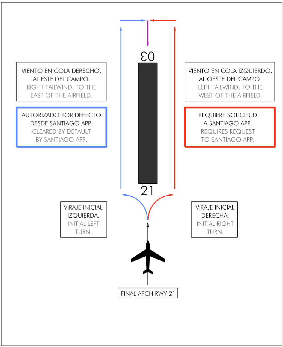
Due to visual traffic operations within the CTR A CORUÑA, if crews require to accomplish the circling manoeuvre to the west of the field, they must request this as early as possible from SANTIAGO APP, so that this service can coordinate with the TWR and have enough time to clear traffic from the circuit required. Otherwise, the request may be denied in the interest of the safety of other aircraft.
When an aircraft is established at the end of RWY 21, entering RWY 03 with a tailwind requires an initial turn to the opposite side of the circuit which it is joining.
ADDITIONAL INFORMATION
Notification issued to aircraft equipped with TCAS, versions earlier than no. 7, operating at A Coruña airport:
-
For permanent radar performance verification of the new en-route radar to be installed in As Pontes, a radar transponder has been installed in the ILS glide path with the following characteristics:
-
Location: 431825.9736N 0082219.4734W.
-
Alpha Mode code: 7777.
-
Antenna altitude: 300 ft.
-
Aircraft equipped with TCAS, versions earlier than no. 7, overflying these coordinates at low altitude, may receive TCAS traffic advisories corresponding to this fixed transponder. These indications do not identify real traffic and should be ignored.
Access TWY for the hangar is restricted exclusively to the aircraft of the flying school based at the airport.
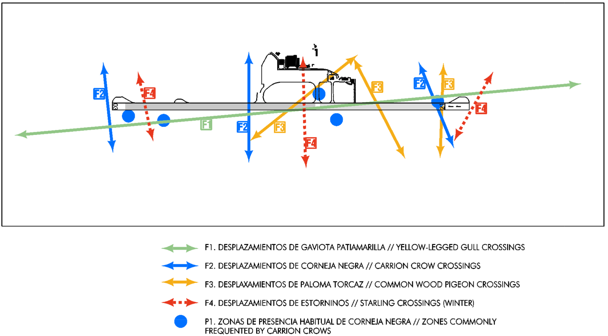
FAUNA CONTROL SERVICE
Fauna Control Service from sunrise to sunset.
BIRD CONCENTRATION AREAS
Caution due to bird concentration on RWY 03/21 particularly during autumn and winter seasons (yellow-legged gulls, common buzzards, carrion crows, spotless starlings, common wood pigeons and passerine birds).
Daily movements of yellow-legged gulls in the early morning, approximately 2 hours after sunrise, and in the late evening, approximately 2 hours before sunset. These crossings increase in April-May (breeding period) and in September-December (juveniles and overwintering birds).
Movements of starlings in winter (November-February) in the early morning and late evening.
Summer presence of black kites (April-July). Occasional presence of curlews in migration crossings (April-May).
The following bird concentration and natural crossing zones are located near the airport grounds:
CHARTS RELATED TO THE AERODROME
The list of charts related to the aerodrome can be found on the link below:
VISUAL SEGMENT SURFACE (VSS) PENETRATION
Not applicable.