GEML AD 2 AERODROME DATA
AERODROME LOCATION INDICATOR AND - NAME
GEML - MELILLA
AERODROME GEOGRAPHICAL AND ADMINISTRATIVE DATAAERODROME GEOGRAPHICAL AND ADMINISTRATION DATA
ARP |
351647N 0025723W. See AD 2-GEML ADC. |
|
Distance and direction from the city |
4 km SW. |
|
Elevation |
48 m/156 ft. |
|
Geoid undulation |
47 m ± 0.15 m (1). |
|
Reference temperature |
29°C. |
|
Low average temperature |
13ºC. |
|
Magnetic variation |
1ºE (2025). |
|
Annual change |
8.8'E. |
|
AD administration |
CIV: Aena. MIL: Ejército del Aire y del Espacio. |
|
Address |
CIV: Aeropuerto de Melilla, Carretera Yasinen s/n; 52005 Melilla. MIL: Comandancia Militar Aérea del Aeropuerto de Melilla, Carretera Yasinen s/n; 52005 Melilla. |
|
TEL |
CIV: CECOA: +34-952 698 622/621 Management: +34-952 698 614 MIL: +34-952 976 972; +34-952 676 615 |
|
FAX |
CIV: CECOA: +34-952 698 677 Management: +34-952 698 608 MIL: +34-917 686 358 |
|
AFTN |
GEML |
|
CIV: melillaCECOA@aena.es |
||
Approved traffic |
IFR/VFR. (2) |
|
Remarks |
(1) For all AD points. (2) Night VFR flights (VFRN) are permitted. |
OPERATIONAL HOURS
Airport |
V: 0515-2015, PS 1 HR PPR; I: 0615-2115, PS 1 HR PPR. |
|
Customs and Immigration |
No. |
|
Health and Sanitation |
No. |
|
AIS |
H24. (1) |
|
ARO |
H24. (2) |
|
MET briefing |
V: 0430-2000; I: 0530-2100. |
|
ATS |
V: 0500-2035, I: 0600-2135. In case PPR is activated: V: 0500-2135, I: 0600-2235. |
|
Fuelling |
HR AD. |
|
Handling |
HR AD. |
|
Security |
HR AD. |
|
De-icing |
No. |
|
Remarks |
State aircraft operating on the military apron shall request permission the previous working day during 0800-1400 LT by
Airport operational schedule: V: 0500-2035, I: 0600-2135. In the event of activation of PPR: V: 0500-2135, I: 0600-2235. (1) Centralised AIO Office - International NOTAM Office
(2) Centralised ARO office geographical area 14
|
HANDLING SERVICES AND FACILITIES
Cargo facilities |
CIV: Warehouse, goods lift, vehicles for transport. MIL: Manual pallet-lifter, Cargo trailer, Forklifts up to 4500 kg, platform for 3 pallet HCU. |
|
Fuel types |
JET A-1 (1). |
|
Oil types |
No. |
|
Refuelling capacity |
JET A-1:
|
|
De-Icing facilities |
No. |
|
Hangar space |
No. |
|
Repair facilities |
No. |
|
Remarks |
MIL: GPU: AC (up to 100 KVA) and DC units (up to 2500 A peak / 1000 A permanent). Ramp agents:
|
PASSENGER FACILITIES
Hotels |
No. |
|
Restaurant |
Yes. |
|
Transportation |
CIV: Taxis. MIL: Crew minibus O/R. |
|
Medical facilities |
No. |
|
Bank/Post Office |
No/No. |
|
Tourist information |
Yes. |
|
Remarks |
None. |
RESCUE AND FIRE FIGHTING SERVICES
Fire category |
5. |
|
Rescue equipment |
In accordance with the fire category published. |
|
Removal of disabled aircraft |
External service for removal of aircraft, prior notice and charged to the owner/operator. Means available MAX: AT 76 and general aviation. Capacity of towing and raising. |
|
Remarks |
None. |
RUNWAY SURFACE CONDITION ASSESSMENT AND REPORTING, AND SNOW PLAN
Types of clearing equipment |
Not applicable. |
|
Clearance priorities |
Not applicable. |
|
Use of material for movement area surface treatment |
Not applicable. |
|
Specially prepared winter runways |
Not applicable. |
|
Remarks |
Runway surface condition assessment and reporting in accordance with the Global Reporting Format (GRF) methodology described in AD 1.2.2. Aerodrome in service during all seasons of the year. |
APRONS, TAXIWAYS AND CHECK LOCATIONS/POSITIONS DATAMOVEMENT AREA DETAILS
Apron |
Surface: CIV: Concrete. MIL: Asphalt / Soil compacted. Strength: CIV: General aviation G1 & G2: PCN 34/R/C/W/T. PRKG H1/ L1 & L2/P2: PCN 17/R/C/W/T. PRKG L3/P3: PCN 13/R/B/W/T. PRKG L4/P4 & H5/L5/P5: PCN 28/R/B/W/T. MIL: Information not available. |
|
Taxiways |
Width: CIV: 21.70 m. MIL: 15 m. Surface: CIV and MIL: Asphalt. Strength: CIV: PCN 34/F/A/W/T. MIL: PCN 11/F/A/W/T. |
|
Check locations |
Altimeter: Apron ELEV 51 m / 166 ft. VOR: No. INS: No. |
|
Remarks |
Contact points for vehicles with TWR for access to movement area: R, I-1, I-2, D-1, D-2, P and V. See AD 2-GEML ADC. TWY centre line: see INSIGNIA and Data Set. |
SURFACE MOVEMENT GUIDANCE AND CONTROL SYSTEM AND MARKINGSTAXIING GUIDANCE SYSTEM AND MARKINGS
Taxiing guidance system |
Boards, runway-holding positions, stands and runway guard lights. |
|
RWY markings |
Designators, centre line, side stripe, threshold, threshold RWY 15 displaced, touchdown zone and aiming point. |
|
TWY markings |
Centre line and side stripe. |
|
Remarks |
None. |
AERODROME OBSTACLES
Obstacles which penetrate Approach, Take-Off Climb, Conical, Inner Horizontal, Transitional, Inner Transitional and Balked Landing Surfaces established in ICAO Annex 14; and the areas 2A and 3 established in ICAO Annex 15. Those penetrating these surfaces are identified in the CSV file as "Relevante_Relevant = Si/Yes". |
See Item 10 and Data Set. |
|
Remarks |
See AD 2-GEML AOC. |
METEOROLOGICAL INFORMATION PROVIDEDMETEOROLOGICAL SERVICE PROVIDED
MET office |
Melilla EMAe. |
|
HR |
V: 0430-2000; I: 0530-2100. Outside this schedule, a half-hourly METAR AUTO will be issued. |
|
METAR |
Half-hourly. |
|
TAF |
24 HR. |
|
TREND |
No. |
|
Briefing |
In person and by telephone. |
|
Flight documentation/Language |
Charts and plain language/Spanish. |
|
Charts |
Forecasted significant and wind and temperature in altitude maps. |
|
Supplementary equipment |
Clouds image, lightnings and radar information display. |
|
ATS unit served |
TWR. |
|
Additional information |
Sevilla OMAe (LESV): H24
Melilla EMAe: HR AD
|
|
Remarks |
Aerodrome climatological summary available. Aerodrome warnings available. |
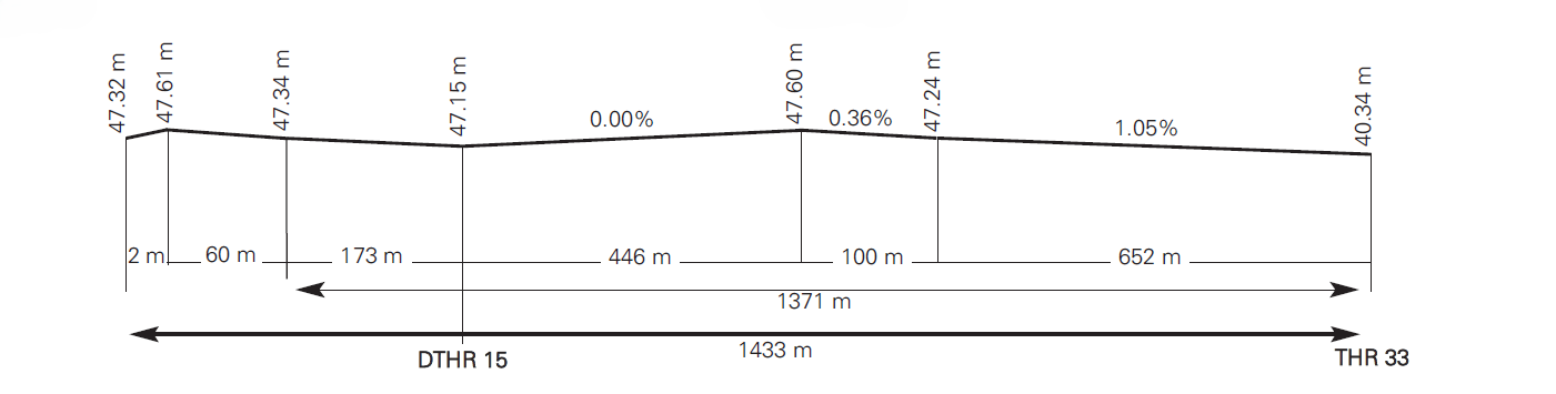
RUNWAY PHYSICAL CHARACTERISTICS
RWY |
Direction |
DIM (m) |
THR PSN |
THR ELEV TDZ ELEV |
SWY (m) |
CWY (m) |
Strip (m) |
OFZ |
RESA (m) |
SFC PCN |
|---|---|---|---|---|---|---|---|---|---|---|
15 (1) (3) |
146.27°GEO 146°MAG |
1433 x 45 |
351701.94N 0025734.36W |
THR: 47 m/155 ft TDZ: No |
No |
No |
1553 x 150 (4) |
No |
90 x 90 |
RWY: ASPH PCN 35/F/A/W/T SWY: No |
33 (2) |
326.27°GEO 326°MAG |
1371 x 45 |
351629.60N 0025708.04W |
THR: 40 m/132 ft TDZ: No |
No |
60 x 150 |
1491 x 150 |
No |
90 x 90 |
RWY: ASPH PCN 35/F/A/W/T SWY: No |
Remarks: (1) THR RWY 15 displaced 235 m. (2) End RWY 33 coordinates: 351706.61N 0025738.17W. (3) RWY 15: Physical start: 351708.28N 0025739.52W. (4) Last 31.8 m RWY 15 left side: strip decreases to 143.3 m. |
||||||||||
Profile
DECLARED DISTANCES
RWY |
TORA (m) |
TODA (m) |
ASDA (m) |
LDA (m) |
|---|---|---|---|---|
15 |
1433 |
1433 |
1433 |
1198 |
33 |
1371 |
1431 |
1371 |
1371 |
Remarks: None. |
||||
APPROACH AND RUNWAY LIGHTING
Runway |
15 |
|
Approach |
Single, 300 m. Threshold identification lights. LIH. |
|
PAPI (MEHT) |
4.38º (11.94 m / 39 ft). |
|
Threshold |
Green. |
|
Touchdown zone |
No. |
|
Runway centreline |
No. |
|
Runway edge |
1433 m: 235 m red + 784 m white + 414 m yellow. (1) Distance between lights: 50 m. |
|
Runway end |
Red. |
|
Stopway |
No. |
|
Remarks |
(1) Adjustable light intensity. Guided centreline lights on turn pad: Green and adjustable light intensity. |
Runway |
33 |
|
Approach |
Threshold identification lights. |
|
PAPI (MEHT) |
3° (9.12 m / 30 ft). |
|
Threshold |
Green. |
|
Touchdown zone |
No. |
|
Runway centreline |
No. |
|
Runway edge |
1371 m: 913 m white + 458 m yellow. (1) Distance between lights: 50 m. |
|
Runway end |
Red. |
|
Stopway |
No. |
|
Remarks |
(1) Adjustable intensity. Guided centreline lights on turn pad: Green and adjustable light intensity. |
OTHER LIGHTING, SECONDARY POWER SUPPLY
ABN/IBN |
No. |
|
WDI |
1 near THR 15, 1 near THR 33. LGTD. |
|
TWY lighting |
Edge. |
|
Apron lighting |
Edge. |
|
Secondary power supply |
Uninterrupted power supply for the entire lighting system. |
|
Remarks |
None. |
HELICOPTER LANDING AREA
Position |
FATO: RWY 15/33. Coordinates THR 15 and THR 33, see item 12. Ground taxiing: TLOF coincides with RWY 15/33. Coordinates THR 15 and THR 33, see item 12. Air taxiing: TLOF coincides with PRKG H1 or H5 of civil apron. See AD 2-GEML PDC. |
|
Elevation |
FATO: RWY 15/33. Elevation THR 15 and THR 33, see item 12. Ground taxiing: TLOF coincides with RWY 15/33, see item 12. Air taxiing: TLOF coincides with PRKG H1 or H5 of civil apron. |
|
Dimensions, surface, maximum weight, marking |
FATO: RWY 15/33. See item 12 and AD 2-GEML ADC. Ground taxiing: TLOF coincides with RWY 15/33. See item 12 and AD 2-GEML ADC. Air taxiing: TLOF coincides with PRKG H1 or H5 of civil apron. See AD 2-GEML PDC. PRKG H5: Concrete PCN 28/R/B/W/T. PRKG H1: Concrete PCN 17/R/B/W/T. |
|
Direction |
FATO coincides with RWY 15/33. See item 12. |
|
Declared distances |
FATO coincides with RWY 15/33. See item 13. |
|
Lighting |
RWY 15/33 see item 14, apron see item 15. |
|
Remarks |
None. |
AIR TRAFFIC SERVICES AIRSPACE ATS AIRSPACE
Designation |
ATZ MELILLA. |
|
| Lateral limits | Circle radius 8 km centred on ARP. (1) | |
Vertical limits |
SFC - 3000 ft HGT. (2) |
|
Airspace class |
D. |
|
Unit Language |
MELILLA TWR. ES/EN. |
|
Transition altitude |
1850 m/6000 ft. |
|
Hours of applicability |
- |
|
Remarks |
(1) Or the ground visibility, whichever is lower. (2) Or up to the cloud ceiling, whichever is lower. |
AIR TRAFFIC SERVICES COMMUNICATION FACILITIESATS COMMUNICATION FACILITIES
Service |
Call sign |
FREQ |
HR |
Remarks |
|---|---|---|---|---|
TWR |
Melilla |
119.525 MHz |
HR ATS |
- |
121.500 MHz |
HR ATS |
EMERG |
||
139.300 MHz |
HR ATS |
MIL |
||
121.775 MHz |
HR ATS |
GMC / BACK-UP |
||
257.800 MHz |
HR ATS |
MIL |
RADIO NAVIGATION AND LANDING AIDSRADIO NAVIGATION & LANDING FACILITIES
Facility (VAR) |
ID |
FREQ |
HR |
Coordinates |
ELEV DME |
Remarks |
|---|---|---|---|---|---|---|
DVOR (1ºE) |
MEL |
114.250 MHz |
H24 |
351649.6N 0025729.4W |
- |
U/S BTN R-120/R-270. |
DME |
MEL |
CH 89Y |
H24 |
351649.2N 0025729.8W |
60 m |
U/S BTN R-120/R-270. |
NDB (1ºE) |
MIA |
292.000 kHz |
H24 |
351828.1N 0025719.9W |
- |
COV 25 NM AVBL BTN: 280º/085º at 6000 ft AMSL or ABV. 85º/280º U/S. |
DME |
MLL |
CH 121X 117.400 MHz |
H24 |
351826.6N 0025719.5W |
120 m |
COV 25 NM AVBL BTN: 280º/085º at 6000 ft AMSL or ABV. 085º/280º U/S. COV 40 NM AVBL BTN: 320º/360º at FL90 or ABV, 360º/045º at 4000 ft AMSL or ABV. |
LOCAL AERODROME REGULATIONSLOCAL REGULATIONS
USE OF APRON
All surface movements of aircraft, towed aircraft, persons and vehicles in the manoeuvring area are subject to prior ATC clearance. All movements of aircraft, towed aircraft, persons and vehicles on the apron shall be regulated by the Apron Safety Regulations.
Powerback manoeuvre is only permitted after request from CECOA and express authorization.
On requesting start-up, pilots shall notify the stand they occupy and inform of the need for cross-bleed start-up if this is necessary.
Avoiding collisions with other aircraft or obstacles is the responsibility of:
-
Pilots during taxiing on the apron.
-
Ground handling companies during the push-back manoeuvre or exit from the stand.
TWR shall facilitate the stand to the pilot of the aircraft once it is on the ground.
Guiding service by a "FOLLOW ME" vehicle is not provided.
While an aircraft is entering or vacating PRKG L1/H1, the taxiing of any other aircraft via the access TWY to PRKG G1 and G2 will be prohibited. Additionally, the movement of vehicles along the adjacent service road will not be permitted during this time.
USE OF RUNWAY
Back-track manoeuvres only permitted on the turn pads provided on the runway other than when indicated otherwise by the ATS/TWR service.
Operations of banner towing are prohibited.
OTHER RESTRICTIONS
There are no usage restrictions for aircraft with a reference code equal to or lower than the one declared for the airport (3C), with the exception of the Bombardier Q400, which is not authorised to operate.
HELICOPTER OPERATIONS
Helicopter operations (take-off/landing) authorised on runway and air or ground taxiing, as appropriate, up to PRKG H1 or H5.
PARKING AND TAXIING OF AIRCRAFT WITH A WINGSPAN HIGHER THAN AT76
Aircraft with a wingspan higher than ATR 72-600 shall only park at Stand L2. When these aircraft enter and exit L2, Stands H1/L1 and L3/P3 shall be restricted.
OPERATIONAL SAFETY REPORTS
Pilots/operator shall report to the airport as soon as possible about any accidents, incidents, occurrences or events which may have a potential operational impact and in which they have been involved or witnessed. The aim of these reports is the compilation of the information in order to improve operational safety, independently of the compulsory report of the occurrence to the appropriate aeronautical authority. Data may be sent in any format, including at least the following information:
-
Date and time.
-
Site.
-
Parties involved (data used to identify vehicles, aircraft...involved).
-
Companies implicated.
-
Description of the facts.
-
Any other data considered relevant (e.g. lighting conditions, weather, phase of the operation such as take-off / landing / stopover, pavement conditions…).
Contact e-mail address of the airport, for the reception of operational safety reports, is the following: SeguridadOperacionalMLN@aena.es
In addition to notifying the airport by means of the indicated system, it is necessary to send at least basic data of the accident, incident, occurrence or event to the air traffic control service provider (ATC).
On the specific instance of safety reports related with the air traffic control service provider (manoeuvring area, flight phases and ATS airspace) these may be sent to the e-mail address: lecsdptosafetymg@enaire.es
OPERATIONAL PROCEDURE FOR HIGHER CODE LETTER AIRCRAFT
GENERAL
The following code letter D military aircraft are authorised to operate at Melilla Airport: Airbus A400M, Lockheed C130 and Transall C160.
Operations by other code letter D aircraft are not permitted.
SURFACE MOVEMENT
-
Arrivals: Land and taxi via runway up to opposite threshold, turn on turn pad and vacate runway via TWY MIL or, exceptionally, via TWY C when the civil apron is in use.
-
Departures: Enter runway via TWY MIL or, exceptionally, via TWY C when the civil apron is in use, taxi to threshold and turn on turn pad to line up.
PARKING
Aircraft that are the object of this procedure shall park autonomously on the military apron. Use of the civil apron for aircraft parking may be permitted only under exceptional circumstances and with prior notification to Melilla Airport.
OPERATIONAL RESTRICTIONS
These aircraft shall taxi at reduced speed and, whenever possible, with the outer engines off and the other engines idling.
The PAPI is not usable for the operation of these aircraft.
Use of the civil apron by aircraft with a higher code letter shall only take place outside operational hours and is subject to prior notification to Melilla Airport.
Pavement markings on the civil apron and signage on TWY C are not available for aircraft with a higher code letter.
The presence of personnel or ground vehicles on the civil apron is not permitted while a higher code letter aircraft is taxiing or has engines running, except for RFFS vehicles and personnel.
GENERAL AND BUSINESS AVIATION
General Aviation aircraft must have engaged a Handling Agent to operate at this airport in any of the following cases:
-
Flights whose origin and/or destination is in a Non-Schengen country.
-
Flights with origin at an aerodrome which does not apply the departure security measures provided for in the Regulation (EU) 300/2008.
-
Aircraft whose MTOW is greater than 3.5 tonnes and/or whose wingspan is greater than 12 m (parking on commercial apron).
-
Aircraft using a jet propulsion system.
Exemption: State, hospital, SAR, military, humanitarian and fire fighting flights.
Operational restrictions: The use of General Aviation PRKG G1 and G2 is restricted to daytime hours.
NOISE ABATEMENT PROCEDURES
GROUND ENGINE TEST AREA
Tests on stand: ATR 72-600 aircraft (or less challenging aircraft) when testing at idle regime.
Tests in engine testing zone (PRKG P5): ATR 72-600 aircraft (or less challenging aircraft) when the test is at medium and/or full power, provided that PRKG L4/P4 is free. The aircraft must place itself in position P (Poniente).
As an alternative point to PRKG L5/P5/H5, the two Runway heads are available for exceptional cases of apron saturation.
Aircraft that are more challenging than the ATR 72-600 may only perform engine tests (other than those performed at idling speed) at runway thresholds.
Remarks: No engine tests shall be carried out outside the published operational hours. These must be communicated to and authorized in advance by CECOA, and authorized by TWR at start. They shall not be carried out during loading or unloading passengers on the apron.
FLIGHT PROCEDURES
INCOMPATIBILITY BETWEEN THE VOR AND NDB APPROACH PROCEDURES
Accomplishment of the VOR approach by an aircraft is incompatible with the simultaneous accomplishment of the NDB approach by another aircraft; for this reason, preferably, the VOR approach manoeuvre shall be used. Nevertheless, in the event that the pilot intends to perform the NDB approach, GEML shall be informed in advance, so that it is possible to provide the appropriate information to users.
ATS SURVEILLANCE SYSTEMS
ATS surveillance systems may be used at Melilla Airport in providing the AD control service to carry out the following duties:
-
Supervision of flight path of aircraft on final approach;
-
Supervision of the flight path of other aircraft in the vicinity of the aerodrome;
-
Implementation of separation established by RCA section 4.6.7.3 between successive departing aircraft; and
-
Provision of navigation assistance to VFR flights.
The provision of the functions b) and d) is not guaranteed in the ATZ below 1000 ft AMSL, nor in the western half of the ATZ below 1300 ft AMSL.
The provision of function c) is not guaranteed in the ATZ below 1300 ft AMSL for departures from RWY 33, nor below 1000 ft AMSL for departures from RWY 15; similarly, for the provision of this function c), authoritative information about the position of both aircraft is necessary.
Depending on the availability of the ATS surveillance systems, the altitude from which the foregoing functions (namely a), b), c) and d)) can be provided may be affected, or they may even be suspended, in which case aircraft will be notified using the means of aeronautical communication available.
LOW VISIBILITY PROCEDURES (LVP)
Low Visibility Procedures (LVP) are not available at Melilla Airport.
OPERATIONAL STANDSTILL PROCEDURE IN THE MOVEMENT AREA (PPOAM)
An Operational Standstill Procedure in the Movement Area when VIS is below 800 m (PPOAM 800) is available to maintain safety in the movement area in low-visibility situations, which consists of the following phases:
-
PHASE I. Warning: 1100 m ≥ VIS ≥ 800 m;
-
PHASE II. Operational standstill: 800 m > VIS;
-
PHASE III. Operational resumption: VIS ≥ 800 m and firm improving trend.
Information for pilots: In any case, ATC will inform CECOA and, if applicable, coordinate measures in addition to the ones described here.
Uncertainty regarding the position in the manoeuvring area
-
Except as provided in the paragraph below, if a pilot is in doubt about the position of the aircraft relative to the manoeuvring area, he/she shall immediately stop the aircraft and report this event (including the last known position) to ATC.
-
In situations where the pilot is in doubt about the position of the aircraft relative to the manoeuvring area, but recognises that the aircraft is on a runway, the pilot shall immediately report this event (including the last known position) to ATC evacuating the runway as soon as possible, if he/she is able to locate a suitable nearby taxiway, unless ATC indicates otherwise; and shall then stop the aircraft.
Failure of an aircraft
-
Report the situation to ATC and await the arrival of assistance. In the event of being on a runway, if possible and unless ATC should indicate otherwise, vacate it.
Loss of visual contact between traffic
-
In the event of loss of visual contact with another aircraft or a vehicle with which they are maintaining their own separation, report ATC immediately and stop the aircraft.
Communications failure
-
Departing aircraft: the aircraft shall continue by the assigned route and shall stop at the ATC clearance limit, taking extreme care, where it shall hold position and wait for the arrival of an assistance vehicle (SEI).
-
Arriving aircraft: if the aircraft has just landed, it shall hold position after vacating the runway and wait for the arrival of an assistance vehicle.
-
If the aircraft already holds ATC taxiing clearance, it shall continue by the assigned route up to the clearance limit, taking extreme care, where it shall hold position and wait for the arrival of an assistance vehicle.
ADDITIONAL INFORMATION
MIL: VHF radio frequency available for coordination of ground services with State aircraft.
On short final approach to RWY 33, existence of zones of suction due to natural depression of the ground.
ZONES OF BIRD CONCENTRATION
The following zones of bird concentration and passage are located close to the airport:
-
Laguna del Parque Forestal Juan Carlos I, with presence of large gulls, cattle egrets, pigeons and swallows, which come both to drink and to feed on insects.
-
Campo de Golf Público de Melilla, with presence of pigeons, herons (including cattle egrets), gulls, steppe birds, passerines and swallows.
-
Puerto de Melilla, being a feeding and roosting zone for large gulls and, to a lesser extent, pigeons.
-
Acantilados de Aguadú, being a breeding zone for large gulls and, to a lesser extent, pigeons.
-
Los Cortados de Horcas, being a breeding zone for large gulls and, to a lesser extent, pigeons.
-
Colonias de cría de la Ciudad de Melilla, being a breeding zone for large gulls and, to a lesser extent, pigeons.
-
Antigua fábrica de harinas, being a refuge zone for large gulls and pigeons.
-
Granja Tramonti, this is a feeding zone for herons, passerines, starlings and pigeons.
-
Puerto de Beni Enzar, it is a feeding zone for large gulls.
-
Mar Chica, wetland of international importance offering a place of feeding and breeding both for gulls and waders, as well as herons, passerines and feeding zone for large birds of prey and large gulls.
-
Colonias del Cabo Tres Forcas, this is a breeding zone for large gulls.
-
"Altos del Real" Football Field. Shelters large gulls on days of strong easterly winds.
-
University Hospital and Barracks. Shelter and nesting area for large gulls.
-
Granja Escuela Gloria Fuertes.
-
Balsa de Las Adelfas.
-
Palomares de la Federación de Colombicultura.
AERONAUTICAL CHARTS RELATED TO AN AERODROMECHARTS RELATED TO THE AERODROME
The list of charts related to the aerodrome can be found on the link below:
VISUAL SEGMENT SURFACE (VSS) PENETRATION
Not applicable.