LEMO AD 2 AERODROME DATA
AERODROME LOCATION INDICATOR AND - NAME
LEMO - SEVILLA/Morón
AERODROME GEOGRAPHICAL AND ADMINISTRATIVE DATA
ARP |
371030N 0053658W. See AD 2-LEMO ADC. |
|
Distance and direction from the city |
50 km SE Sevilla, 17 km NW Morón. |
|
Elevation |
87 m / 285 ft. |
|
Geoid undulation |
47.04 m ± 0.05 m. |
|
Reference temperature |
34°C. |
|
Low average temperature |
9ºC. |
|
Magnetic variation |
1ºW (2020). |
|
Annual change |
7.8'E. |
|
AD administration |
Ejército del Aire y del Espacio. |
|
Address |
Base Aérea de Morón - Ctra Sevilla-Morón km 17. 41530 - Morón de la Frontera (Sevilla). |
|
TEL |
+34-954 842 200 |
|
| FAX | +34-954 842 713 | |
AFTN |
LEMO |
|
Approved traffic |
IFR/VFR. Exclusive military use. |
|
Remarks |
(1) For all AD points. |
OPERATIONAL HOURS
Airport |
H24. (1) |
|
Customs and Immigration |
HR AD. |
|
Health and Sanitation |
HR AD. |
|
AIS/ARO/OPV |
HR AD. |
|
MET briefing |
HR AD. |
|
ATS |
HR AD. |
|
Fuelling |
HR AD. |
|
Handling |
HR AD. |
|
Security |
H24. |
|
De-icing |
No. |
|
Remarks |
(1) Foreign State aircraft will request compulsory PPR with 72 HR in advance. Requests will be done via:
DoD (Department of Defence, USA) ACFT will contact with USAF AMOPS at DNS: 814-722-8418/8419 for PPR request. |
HANDLING SERVICES AND FACILITIES
Cargo facilities |
Forklifts up to 8 Tm and 4 Tm, cargo transferrer (load MAX 30000 pounds), towable passenger gangway, docking material (chains, straps, tensors and pallet packaging), pallet-lifters (towable) and pallet platforms (fixed). |
|
Fuel types |
F-34. |
|
Oil types |
G-353, G-359, G-372, G-382, G-392, H-515, H-537, H-5420-133, O-142, O-148, O-153, O-156, O-190, O-226, O-228, O-1236. |
|
Refuelling capacity |
Trucks:
Pumping truck (EA ACFT only). |
|
De-Icing facilities |
No. |
|
Hangar space |
No. |
|
Repair facilities |
No. |
|
Remarks |
Unit of AC (115V 400HZ 60 KVA) and DC (24/28V 2500A). Liquid oxygen O/R. |
PASSENGER FACILITIES
Hotels |
Yes. |
|
Restaurant |
Yes. |
|
Transportation |
Buses and light vehicles according to availability and on request. |
|
Medical facilities |
First aid and ambulance. |
|
Bank/Post Office |
Yes/No. |
|
Tourist information |
No. |
|
Remarks |
None. |
RESCUE AND FIREFIGHTING SERVICES
Fire category |
6 extendible to 8 with PPR 48 HR in advance. |
|
Rescue equipment |
In accordance with the fire category published. |
|
Removal of disabled aircraft |
Facilities suitable for the aircraft based at the unit. |
|
Remarks |
None. |
RUNWAY SURFACE CONDITION ASSESSMENT AND REPORTING, AND SNOW PLAN
Equipment |
Aircraft lifting crane (30000 kg), snow blower sweeper. |
|
Priority |
Runways, taxiways and apron. |
|
Remarks |
None. |
APRONS, TAXIWAYS AND CHECK LOCATIONS/POSITIONS DATAMOVEMENT AREA DETAILS
Apron |
Surface: Concrete. Strength: P1: PCN 49/R/B/W/T; P2: PCN 28/R/B/W/T; P3: PCN 24/R/C/W/T; P4: PCN 71/R/B/W/T; P5: PCN 27/R/B/W/T. |
|
Taxiways |
Width: 22.86 m. Surface: A, D, C1 (East segment), C2, C3, C5, C6: Concrete; B, C, C1 (West segment), TA1, TA2, TA3: Asphalt. Strength: A: PCN 48/R/B/W/T; B: PCN 57/F/A/W/T; C: PCN 61/F/A/W/T; D: PCN 81/R/B/W/T; TA-1: PCN 37/F/A/W/T; TA-2: PCN 39/F/A/W/T; TA-3: PCN 40/F/A/W/T; C-1: PCN 17/R/C/W/T; C-2: PCN 64/R/B/W/T; C-3: PCN 44/R/B/W/T; C-4: PCN 37/R/B/W/T; C-5: PCN 36/R/B/W/T; C-6: PCN 36/R/C/W/T. |
|
Check locations |
Altimeter: No. VOR: No. INS: No. TACAN: TWY A and D. |
|
Remarks |
P1 divided into Ejército del Aire y del Espacio area (South part) and USA area (North part). Caution: Shelters C16. |
SURFACE MOVEMENT GUIDANCE AND CONTROL SYSTEM AND MARKINGSTAXIING GUIDANCE SYSTEM AND MARKINGS
Taxiing guidance system |
Runway-holding positions, boards and stop bars. |
|
RWY markings |
Designators, threshold, centre line, side stripe and touch down zone. |
|
TWY markings |
Centre line and side stripe. |
|
Remarks |
None. |
AERODROME OBSTACLES
In approach and take-off areas |
In circling area and at AD |
|||
|---|---|---|---|---|
RWY Area |
Obstruction | Coordinates |
Obstruction |
Coordinates |
02
|
Radar 3.5 m/11 ft | 371014.0N 0053632.2W |
Arresting gear BAK-12B (B) |
500 m FM THR 02 |
| Radar 3.5 m/11 ft | 371116.6N 0053641.3W |
|||
| Radar 3.5 m/11 ft | 371033.8N 0053701.0W |
|||
| Radar 3.5 m/11 ft | 371030.7N 0053551.1W |
|||
| Radar 3.5 m/11 ft | 370950.4N 0053720.6W |
|||
| Radar 3.5 m/11 ft | 370947.5N 0053710.6W |
|||
| GCA 5 m/16 ft | 371028.6N 0053708.4W |
|||
20
|
Floodlighting pole 132.5 m/435 ft | 2000 m/179ºMAG FM THR20 |
Arresting gear BAK-12B (B) |
495 m FM THR 20 |
| Water tank 140.5 m/461 ft | 1500 m/164°MAG FM THR20 |
Antenna 117.5 m/385 ft |
370927.5N 0053522.8W |
|
| Mountains 587 m/1926 ft | 13000 m/139°MAG FM THR20 |
|
|
|
| Antennas 122 m/400 ft | 3000 m/159°MAG FM THR20 |
|||
Communication antenna 51.2 m/168 ft |
371015.4N 0053619.8W |
|||
| Floodlighting poles | ||||
| 129.31 m/424 ft | 371036.8N 0053623.5W |
|||
| 129.44 m/425 ft | 371031.7N 0053625.8W |
|||
| 128.96 m/423 ft | 371027.8N 0053627.5W |
|||
| 129.13 m/424 ft | 371023.0N 0053629.7W | |||
| 129.31 m/424 ft | 371019.4N 0053631.3W | |||
| 129.37 m/424 ft | 371014.5N 0053633.6W | |||
| 129.50 m/425 ft | 371010.7N 0053635.3W | |||
| 129.81 m/426 ft | 371006.2N 0053637.3W | |||
| 127.19 m/417 ft | 371001.0N 0053629.7W | |||
| 127.41 m/418 ft | 370956.4N 0053641.8W | |||
| 127.54 m/418 ft | 370951.8N 0053644.0W | |||
| Remarks | See AD 2-LEMO AOC. | |||
METEOROLOGICAL INFORMATION PROVIDEDMETEOROLOGICAL SERVICE PROVIDED
MET office |
Morón OMD. |
|
HR |
H24. |
|
METAR |
Half-hourly. |
|
TAF |
24 HR. |
|
TREND |
Yes. |
|
Briefing |
In person and by telephone. |
|
Flight documentation/Language |
Charts and plain language / Spanish and English. |
|
Charts |
Significant, forecasted and wind and temperature in altitude and maximum wind maps. |
|
Supplementary equipment |
Clouds and lightning image and radar information display. |
|
ATS unit served |
OPV, TWR. |
|
Additional information |
Sevilla OMAe (LESV): H24
Morón OMD: H24
|
|
Remarks |
Aerodrome warnings available. Aerodrome climatological summary available. |
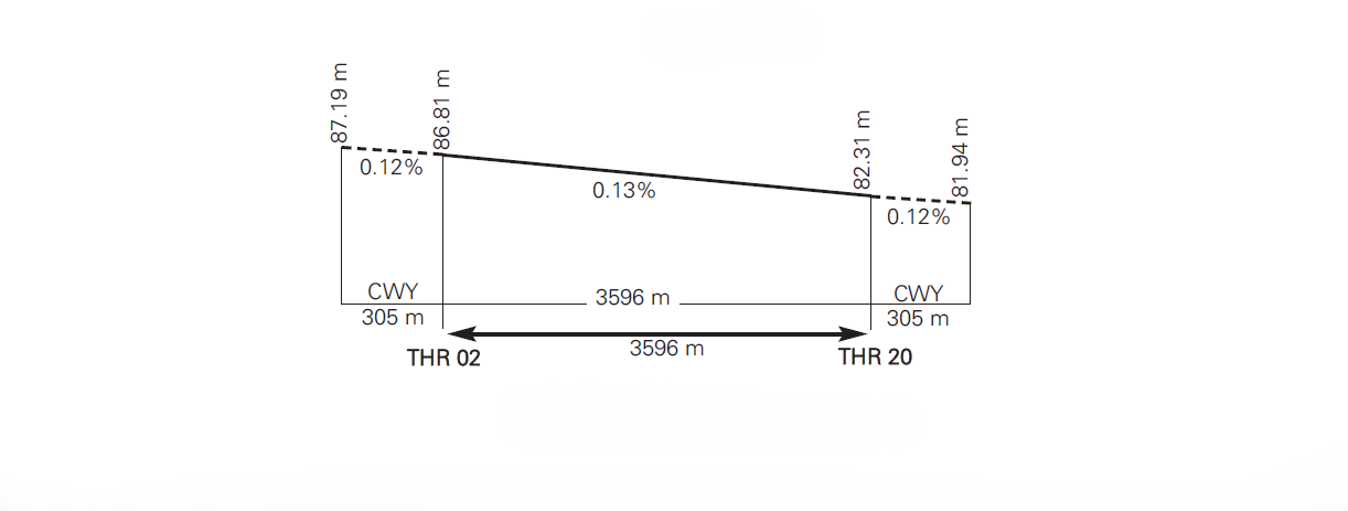
RUNWAY PHYSICAL CHARACTERISTICS
RWY |
Direction |
DIM (m) |
THR PSN |
THR ELEV |
SWY (m) |
CWY (m) |
Strip (m) |
OFZ |
RESA (m) |
RWY/SWY SFC PCN |
|---|---|---|---|---|---|---|---|---|---|---|
02 |
019.83°GEO 021°MAG |
3596 x 61 |
370934.73N 0053722.40W |
THR: 87 m / 285 ft TDZ: No |
305 x 61 |
305 x 61 |
4207 x 91 |
No |
No |
RWY: ASPH PCN 54/F/A/W/T (1) SWY: PCN 44/F/B/W/T |
20 |
199.84°GEO 201°MAG |
3596 x 61 |
371124.47N 0053632.93W |
THR: 82.3 m / 270 ft TDZ: INFO NO AVBL |
305 x 61 |
305 x 61 |
4207 x 91 |
INFO NO AVBL |
No |
RWY: ASPH PCN 54/F/A/W/T (1) SWY: PCN 32/F/B/W/T |
Remarks: (1) First 300 m of each threshold are concrete. (RWY 02: PCN 55/R/B/W/T and RWY 20: PCN 121/R/B/W/T). With wet surface, both TDZ are highly dangerous due to skating or hydroplaning. |
||||||||||
Profile
DECLARED DISTANCES
RWY |
TORA (m) |
TODA (m) |
ASDA (m) |
LDA (m) |
|---|---|---|---|---|
02 |
3596 |
3901 |
3901 |
3596 |
20 |
3596 |
3901 |
3901 |
3596 |
02 INT B |
2393 |
2698 |
2698 |
- |
20 INT C |
2393 |
2698 |
2698 |
- |
Remarks: None. |
||||
APPROACH AND RUNWAY LIGHTING
Runway |
02 |
|
Approach |
Simple (434 m). Runway lead-in lighting system. (1) |
|
PAPI (MEHT) |
3° (INFO NO AVBL). |
|
Threshold |
Green. |
|
Touchdown zone |
No. |
|
Runway centre line |
No. |
|
Runway edge |
3596 m white. (1) |
|
Runway end |
Red. |
|
Stopway |
Red. |
|
Remarks |
(1) Adjustable lights intensity O/R. PAPI contact point outside TDZ and before arresting gear GEAR BAK 12B (B). |
Runway |
20 |
|
Approach |
Precision CAT I LIH (900 m). (1) |
|
PAPI (MEHT) |
3° (INFO NO AVBL). |
|
Threshold |
Green. |
|
Touchdown zone |
No. |
|
Runway centre line |
No. |
|
Runway edge |
3596 m: 2945 m white + 651 m yellow. (1) |
|
Runway end |
Red. |
|
Stopway |
Red. |
|
Remarks |
(1) Adjustable lights intensity O/R. PAPI contact point outside TDZ and before arresting gear GEAR BAK 12B (B). |
OTHER LIGHTING, SECONDARY POWER SUPPLY
ABN |
ALTN FLG W(2) G(1) EV 5 SEC. See AD 2-LEMO ADC (1). |
|
WDI/LDI |
1 near THR 02, 1 near THR 20. |
|
TWY lighting |
Edge. |
|
Apron lighting |
Floodlighting poles, 11 in P1 and 6 in P2. |
|
Secondary power supply |
Yes. |
|
Remarks |
(1) ABN only available O/R. |
HELICOPTER LANDING AREA
Position |
No. |
|
Elevation |
No. |
|
Dimensions, surface, maximum weight, marking |
No. |
|
Direction |
No. |
|
Declared distances |
No. |
|
Lighting |
No. |
|
Remarks |
None. |
AIR TRAFFIC SERVICES AIRSPACE ATS AIRSPACE
Designation |
CTR MORÓN. |
|
Lateral limits |
Circle radius 6.5 NM centred on ARP. |
|
Vertical limits |
SFC - 1000 ft HGT. |
|
Airspace class |
D. |
|
Unit |
SEVILLA APP. ES/EN. |
|
Transition altitude |
1850 m / 6000 ft. |
|
Hours of applicability |
- |
|
Remarks |
None. |
Designation |
ATZ MORÓN. |
|
Lateral limits |
Circle radius 8 km centred on ARP. (1) |
|
Vertical limits |
SFC - 3000 ft HGT. (2) |
|
Airspace class |
D. |
|
Unit |
MORÓN TWR. ES/EN. |
|
Transition altitude |
- |
|
Hours of applicability |
- |
|
Remarks |
(1) Or the ground visibility, whichever is lower. (2) Or up to the cloud ceiling, whichever is lower. |
AIR TRAFFIC SERVICES COMMUNICATION FACILITIESATS COMMUNICATION FACILITIES
Service |
Call sign |
FREQ |
HR |
Remarks |
|---|---|---|---|---|
APP |
Sevilla APP |
120.000 MHz |
H24 |
- |
120.800 MHz |
H24 |
APP/L (South sector) |
||
128.500 MHz |
H24 |
APP/H (North sector) |
||
TWR |
Morón TWR |
122.100 MHz |
H24 |
- |
139.300 MHz |
H24 |
MIL |
||
257.800 MHz |
H24 |
- |
||
337.900 MHz |
H24 |
GMC |
||
258.100 MHz |
H24 |
- |
||
121.500 MHz |
H24 |
EMERG |
||
243.000 MHz |
H24 |
EMERG |
||
258.900 MHz |
H24 |
GMC (USAF) |
||
396.850 MHz |
H24 |
(USAF) |
||
GCA |
Morón RADAR |
138.550 MHz |
(1) |
(3, 4, 5) |
276.800 MHz |
(1) |
(3, 4, 5) |
||
342.000 MHz |
(1) |
(3, 4, 5) |
||
143.200 MHz |
(1, 2) |
(3, 4, 5) |
||
| Remarks |
|
|||
RADIO NAVIGATION AND LANDING AIDSRADIO NAVIGATION & LANDING FACILITIES
Facility (VAR) |
ID |
FREQ |
HR |
Coordinates |
DME ELEV |
Remarks |
|---|---|---|---|---|---|---|
LOC 20 (1ºW) ILS CAT I |
IMRF |
109.700 MHz |
H24 |
370925.0N 0053726.8W |
- |
- |
GP 20 |
- |
333.200 MHz |
H24 |
371116.7N 0053641.7W |
- |
3°; RDH 10.5 m at 320 m FM THR 20 & 132 m FM RCL on the right in the APCH direction. |
ILS/DME 20 |
IMRF |
CH 34 X |
H24 |
371116.7N 0053641.7W |
81 m |
REF THR 20. |
VOR (1ºW) |
MRN |
115.500 MHz |
H24 |
371030.2N 0053708.0W |
- |
- |
DME |
MRN |
CH 102 X |
H24 |
371030.2N 0053708.0W |
90 m |
- |
TACAN (1ºW) |
MRN |
CH 100 X |
H24 |
371024.1N 0053714.1W |
90 m |
HR MAINT: V: THU 0500-0700; I: THU 0600-0800. |
LOCAL AERODROME REGULATIONSLOCAL REGULATIONS
USA AIRCRAFT
PREOCOPE authorization (military and civil aircraft operating for the USA government).
3rd NATIONALITY AIRCRAFT
Diplomatic authorization and PPR.
SPANISH CIVIL AIRCRAFT
Estado Mayor del Aire (EMA) authorization and PPR.
BACKTRACK
Only authorized in THR (concrete) with turn from W to E avoiding foreign object debris damage (FOD) in the TWY / See LEMO item 12.
TOUCH AND GOES
-
Vertical (aeroplanes): These may not be accomplished in the asphalt areas or on earth. They will only be cleared in the concrete pavements.
-
At low speed or with parachute: Notify TWR in advance.
HELICOPTERS
From runway to parking and vice versa, these will use taxiways.
TRANSPORT OF DANGEROUS GOODS
The net explosive quantity (NEQ) must be included in item 18 of Flight Plan. Expected parking in taxiways A, B, C or D depending on the net explosive quantity (NEQ).
TWR EVACUATION
TWR will be evacuated with wind speed equal to or greater than 54 kt.
RADIO FAILURE
Always proceed to intercept the Base leg (East part) of runway 20 maintaining 500 ft, and overfly the aircraft ramp (between runway and control tower). Determine the runway in use by the yellow panels of the control tower. Maintain the radio failure traffic circuit, going around the control tower and the 11 floodlighting poles to the EAST and repeating the circuit until light signals are received (GREEN: Land, heading to the base leg (EAST part) of the runway in use. On vacating the runway await the "FOLLOW ME" vehicle; RED: once, repeat the circuit / twice, proceed to the alternate AD). Acknowledgement: Rock wings by day and flash landing lights twice by night.
PROCEDURE FOR REDUCING THE RISK OF BIRD STRIKE
Procedure not applicable to USA DoD aircraft.
Moderate bird watch conditions (BWC Moderate):
-
No transit or touchdowns and take-offs shall take place.
-
No practices, exhibitions or aerial trials will be cleared.
-
Unless strictly necessary, take-offs/landings in formation will not be conducted.
Severe bird watch conditions (BWC Severe):
-
No take-offs will be cleared except for helicopters.
-
No transit or low approaches shall take place.
-
Only traffic for final touchdown shall be cleared (the aircraft commander shall assume the risk).
TURNING RADIUS LIMITATION TO 90° ON TWY B AND C
There are restrictions on heavy aircraft turning right to enter the runway from TWY C, or turning left to enter TWY C from the runway. The same is true of turning left to access the runway from TWY B and turning right to access TWY B from the runway.
NOISE ABATEMENT PROCEDURES
RWY 02
Due to noise abatement procedures, aircraft on departure from RWY 02 shall fly with heading 008°. Once 3000 ft or 6 NM is reached, resume the departure procedure or follow ATC instructions.
VFR flights must avoid overflying "El Arahal".
IFR flights approaching by the EAST part outside the defined paths shall not enter the CTR below 3000 ft, but follow one of the paths published in the IAC.
RWY 20
Due to noise abatement procedures, aircraft on departure from RWY 20 shall fly with heading 218°. Once 3000 ft or 6 NM is reached, resume the departure procedure or follow ATC instructions.
VFR flights must avoid overflying "El Coronil".
IFR flights approaching by the EAST part outside the defined paths shall not enter the CTR below 3000 ft, but follow one of the paths published in the IAC.
VISUAL ARRIVALS (POINTS W AND E)
Do not circle or overfly the towns of UTRERA or MORÓN DE LA FRONTERA lower than 3000 ft.
QUIET HOURS
The hours defined as 'quiet hours' for the Base run from 2300 LT to 0600 LT.
During this period, and unless expressly otherwise authorized by the competent authority, no manoeuvre implying start-up of engines, including engine testing, approach manoeuvres and/or local VFR/IFR training flights, shall be cleared.
FLIGHT PROCEDURES
LOW VISIBILITY PROCEDURES
Low Visibility Procedures (LVP) are not available at Morón Air Base.
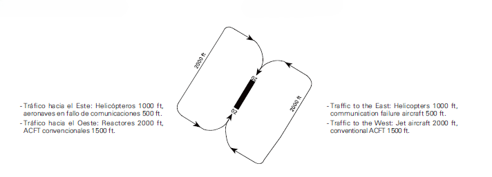
AD TRAFFIC CIRCUIT
ADDITIONAL INFORMATION
ARRESTING SYSTEMS
Nomenclature: LEMO-01-C-B.
Type: RETRACTABLE CABLE BARRIER BIDIRECTIONAL.
Location: RWY 02 THR+500 m/1640 ft. RWY 20 THR+3096 m/10157 ft.
Readiness status: Permanently available.
Nomenclature: LEMO-02-C-B.
Type: RETRACTABLE CABLE BARRIER BIDIRECTIONAL.
Location: RWY 02 THR+3101 m/10174 ft. RWY 20 THR+495 m/1624 ft.
Readiness status: Permanently available.
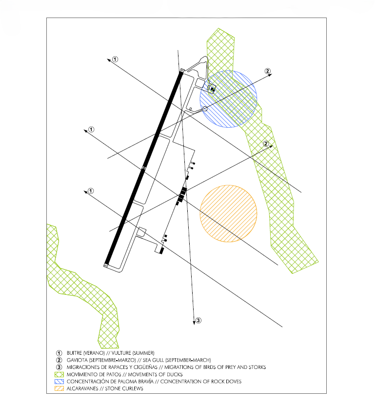
BIRDS AREAS OF CONCENTRATION AND FLOWS
RADAR INSTRUMENT APPROACH MINIMA
|
RWY | GP/TCH/RPI |
CAT |
DH/MDA-VIS |
HAT/HAA |
CEIL-VIS |
|---|---|---|---|---|---|---|
PAR |
20 | 3°/34/634 |
ALL |
470-800 |
200 |
200-800 |
PAR |
02 | 3°/66/1258 |
ALL |
485-800 |
200 |
200-800 |
SRE |
02 | A-B |
830-800* |
537 |
600-800* |
|
SRE |
02 | C |
830-1600 |
537 |
600-1600* |
|
SRE |
02 | D-HPMA |
830-2000 |
537 |
600-2000* |
|
SRE |
02 | E |
830-2400 |
537 |
600-2400* |
|
SRE |
20 | A-B |
690-800* |
411 |
400-800* |
|
SRE |
20 | C |
690-1200** |
411 |
400-1200** |
|
SRE |
20 | D-HPMA |
690-1200 |
411 |
400-1200** |
|
SRE |
20 | E |
690-1600 |
411 |
400-1600** |
|
CIR |
A |
830-1600 |
541 |
600-1600 |
||
CIR |
B |
830-1600 |
541 |
600-1600 |
||
CIR |
C |
940-2800 |
645 |
700-2800 |
||
CIR |
D |
1100-4000 |
809 |
900-4000 |
||
CIR |
HPMA |
910-3200 |
619 |
700-3200 |
||
CIR |
E |
1220-4800 |
934 |
1000-4800 |
Remarks:
* If approach lighting system is out of service, increase visibility by 800 m.
** If approach lighting system is out of service, increase visibility by 400 m.
AERONAUTICAL CHARTS RELATED TO AN AERODROMECHARTS RELATED TO THE AERODROME
The list of charts related to the aerodrome can be found on the link below:
VISUAL SEGMENT SURFACE (VSS) PENETRATION
Not applicable.