LEPP AD 2 AERODROME DATA
AERODROME LOCATION INDICATOR AND- NAME
LEPP - PAMPLONA
AERODROME GEOGRAPHICAL AND ADMINISTRATIVE DATA
ARP |
424612N 0013847W. See AD 2 - LEPP ADC. |
|
Distance and direction from the city |
6 km S. |
|
Elevation |
459 m / 1506 ft. |
|
Geoid undulation |
49.86 ± 0.05 (1). |
|
Reference temperature |
28°C. |
|
Low average temperature |
4ºC. |
|
Magnetic variation |
1ºE (2025). |
|
Annual change |
9.6' E. |
|
AD administration |
Aena. |
|
Address |
Aeropuerto de Pamplona - Pamplona (Navarra). |
|
TEL |
+34-948 168 700/740 |
|
AFTN |
LEPP |
|
FAX |
+34-948 168 707/717 |
|
Approved traffic |
IFR/VFR (2) (3). |
|
Remarks |
SITA: PNAOPYA. (1) For all AD points. (2) IFR/VFR General Aviation traffic (except State flights, hospital, SAR and aircraft based at the airport itself) is conditional on apron capacity. A request for slot PPR 24 HR must be made to LEPP CECOA via e-mail at pamplona_cecoa@aena.es (3) For commercial flight traffic, coordinate according to GEN 1.2 to SITA address PNAOPYA. |
OPERATIONAL HOURS
Airport |
V: 0430-2145 PS 45 MIN PPR 15 MIN BFR AD CLSD. (1) (2). I: 0530-2245 PS 45 MIN PPR 15 MIN BFR AD CLSD. (1) (2). |
|
Customs and Immigration |
O/R. |
|
Health and Sanitation |
See GEN 1.4. |
|
AIS |
H24. (3) |
|
ARO |
HR AD. (4) |
|
MET briefing |
V: 0300-2230; I: 0400-2330. |
|
ATS |
V: 0415-2205, I: 0515-2305. In case PPR is activated: V: 0415-2250, I: 0515-2350. |
|
Fuelling |
V: MON-SAT 0630-1530 (5) and SUN 0630-1730 (5). I: MON-SAT 0730-1630 (5) and SUN 0730-1830 (5). |
|
Handling |
HR AD. |
|
Security |
HR AD. |
|
De-icing |
HR AD. |
|
Remarks |
Airport hours of activity: V: 0415-2205, I: 0515-2305. In case PPR is activated: V: 0415-2250, I: 0515-2350. (1) For other operational hours, prior request, consult NOTAM in force. (2) PPR only for commercial aviation. (3) Centralised AIO Office - International NOTAM Office
(4) ARO service provided from the operations office of the airport. (5) For other fuelling hours within HR AD, 2 HR PPR is required. |
HANDLING SERVICES AND FACILITIES
Cargo facilities |
Up to 2000 kg. |
|
Fuel types |
JET A-1; 100LL (1). |
|
Oil types |
AEROSHELL-W100. |
|
Refuelling capacity |
JET A-1:
AVGAS 100LL:
|
|
De-icing facilities |
Service provided by handling operator in apron. |
|
Hangar space |
No. |
|
Repair facilities |
No. |
|
Remarks |
(1) Fuel
Agreement with handling services (ramp agent) is mandatory for Commercial, General (2) and Business (2) Aviation operations. (2) General and Business Aviation operations are exempt from the obligation to hire handling services (ramp agent) if they have the following characteristics:
Ramp agent:
Handling agent:
|
PASSENGER FACILITIES
Hotels |
No. |
|
Restaurant |
No. |
|
Transportation |
Taxis and hire cars. |
|
Medical facilities |
No. |
|
Bank/Post Office |
No / No. |
|
Tourist information |
No. |
|
Remarks |
None. |
RESCUE AND FIRE FIGHTING SERVICES
Fire category |
CAT 7. (1) (2) |
|
Rescue equipment |
In accordance with the fire category published. |
|
Removal of disabled aircraft |
Available means: 2 aircraft recovery dollies with a load/haul capacity of up to 5 Tm and 1 aircraft recovery dolly with a load/haul capacity of up to 10 Tm. Local contact details for the operation of removal of disabled aircraft: Centro de Coordinación de Operaciones (Operations Coordination Centre CECOA):
|
|
Remarks |
(1) The response time of the rescue and fire fighting service is less than 3 minutes, with an operational objective of less than 2 minutes. (2) For other fire categories, prior request, consult NOTAM in force. |
RUNWAY SURFACE CONDITION ASSESSMENT AND REPORTING, AND SNOW PLAN
Types of clearing equipment |
Urea spreader, snowplough. |
|
Clearance priorities |
Runway, taxiways and apron. |
|
Use of material for movement area surface treatment |
Urea (UREA). |
|
Specially prepared winter runways |
Not applicable. |
|
Remarks |
Period of application of snow plan: 01-DEC to 31-MAR. Runway surface condition assessment and reporting in accordance with the Global Reporting Format (GRF) methodology described in AD 1.2.2. Aerodrome in service during all seasons of the year. |
Aprons, taxiways and check locations/positions dataMOVEMENT AREA DETAILS
Apron |
Surface: Concrete. Strength: PCN 72/R/A/W/T. |
|
Taxiways |
Width: TWY A: 22 m; TWY B: 10.4 m. Surface: Asphalt. Strength: TWY A: PCN 109/F/A/W/T; TWY B: PCN 17/F/D/W/T. |
|
Check locations |
Altimeter: Apron: ELEV: 455 m / 1494 ft. VOR: No. INS: No. |
|
Remarks |
None. |
Surface movement guidance and control system and markingsTAXIING GUIDANCE SYSTEM AND MARKINGS
Taxiing guidance system |
Horizontal markings, boards, runway-holding, position, stop bar and runway guard lights. Intermediate holding position on taxiway B. |
|
RWY markings |
Designators, threshold, DTHR 33, centre line, side stripe, touchdown zone, aiming point and turn pad. |
|
TWY markings |
Centre line, side stripe. |
|
Remarks |
None. |
AERODROME OBSTACLES
Obstacles which penetrate the horizontal, conical, approach, take-off climb, transitional and balked landing contained in Annex 14 of ICAO; and the areas 2A and 3 contained in Annex 15 of ICAO. |
See Item 10 and Data Set.Digital Data section. |
|
Remarks |
See AD 2-LEPP AOC. |
Meteorological information providedMETEOROLOGICAL SERVICE PROVIDED
MET office |
Pamplona EMAe. |
|
HR |
V: 0300-2230; I: 0400-2330. |
|
METAR |
Half-hourly. Semi-automatic METAR will be issued during V: 0330–2200; I: 0430–2300. Outside these hours, METAR AUTO will be issued. |
|
TAF |
H24. |
|
TREND |
No. |
|
Briefing |
In person and by telephone. |
|
Flight documentation/Language |
Charts and plain language / Spanish. |
|
Charts |
Significant, forecasted in altitude (wind and temperature) and maximum wind maps. |
|
Supplementary equipment |
Clouds image, lightnings and radar information display. |
|
ATS unit served |
TWR. |
|
Additional information |
Santander OMAe (LESD): H24
Pamplona EMAe: HR AD
|
|
Remarks |
Aerodrome climatological summary available. Aerodrome warnings available. |
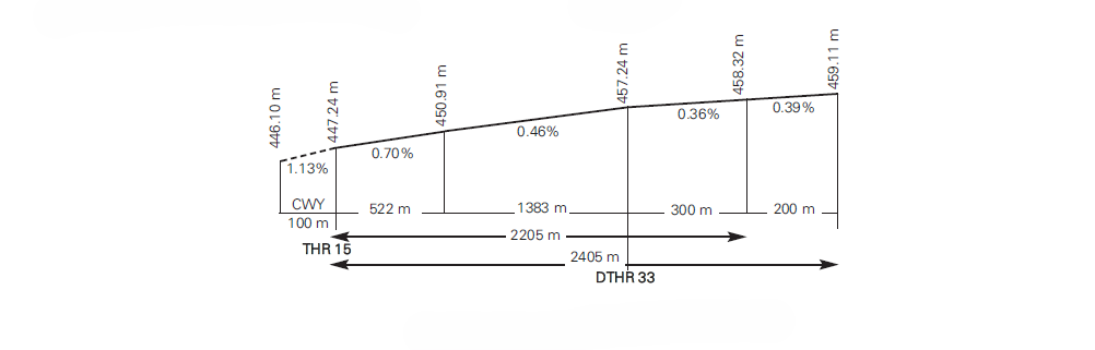
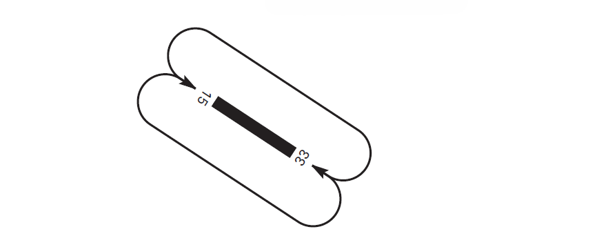
RUNWAY PHYSICAL CHARACTERISTICS
RWY |
Direction |
DIM (m) |
THR PSN |
THR ELEV |
SWY (m) |
CWY (m) |
Strip (m) |
OFZ |
RESA (m) |
RWY/SWY SFC PCN |
|---|---|---|---|---|---|---|---|---|---|---|
15 |
151.77° GEO |
2205 x 45 |
424646.36N 0013911.71W |
THR: 447.2 m / 1467 ft |
No |
80 x 150 |
2325 x 280 (3) |
Sí |
240 x 150 |
RWY: ASPH (2) |
33 (1) |
331.78° GEO |
2405 x 45 |
424551.91N 0013832.03W |
THR: 457 m / 1500 ft |
No |
100 x 150 |
2525 x 280 (3) (4) |
No |
90 X 90 |
RWY: ASPH (2) |
Remarks: (1) THR RWY 33 displaced 500 m. Coordinates of the beginning of the take-off run: 424537.67N 0013821.66W. (2) Asphalted surface FM THR 15:
(3) Taken as reference THR 15, the first 2325 m of the runway strip extends laterally up to a distance of 140 m on each side of the runway centre line except for the following sections:
(4) Taken as reference the beginning of the RWY 33 take-off run, the first 200 m of the runway strip extends laterally up to a distance of 75 m on each side of the runway centre line. |
||||||||||
profile
DECLARED DISTANCES
RWY |
TORA (m) |
TODA (m) |
ASDA (m) |
LDA (m) |
|---|---|---|---|---|
15 |
2205 |
2285 |
2205 |
2205 |
33 |
2405 |
2505 |
2405 |
1907 |
33 INT A |
1869 |
1969 |
1869 |
– |
Remarks: No. |
||||
APPROACH AND RUNWAY LIGHTING
Runway |
15 |
|
Approach |
Precision CAT I, 900 m. LIH. Threshold identification lights. |
|
PAPI (MEHT) |
3.4° (14.27 m/47 ft). |
|
Threshold |
Green with wing bars. |
|
Touchdown zone |
No. |
|
Runway centre line |
2405 m: 1500 m white+600 m red and white+305 m red. LIH. Distance between lights: 15 m. |
|
Runway edge |
2405 m: 1805 m white + 600 m yellow. LIH. Distance between lights: 50 m. |
|
Runway end |
Red. |
|
Stopway |
No. |
|
Remarks |
None. |
Runway |
33 |
|
Approach |
Simple, 420 m. LIH. Threshold identification lights. |
|
PAPI (MEHT) |
3° (7.36 m/24 ft). |
|
Threshold |
Green with wing bars. |
|
Touchdown zone |
No. |
|
Runway centre line |
2405 m: 1505 m white+600 m red and white+300 m red. LIH. Distance between lights: 15 m. |
|
Runway edge |
2405 m: 500 m red + 1305 m white + 600 m yellow. LIH. Distance between lights: 50 m. |
|
Runway end |
Red. |
|
Stopway |
No. |
|
Remarks |
None. |
OTHER LIGHTING, SECONDARY POWER SUPPLY
ABN/IBN |
No. |
|
WDI |
1 near DTHR 33, 1 near THR 15. LGTD. |
|
TWY lighting |
TWY A: Edge. TWY B: No. |
|
Apron lighting |
Edge and 4 floodlighting poles. |
|
Secondary power supply |
Engine generators that provide a maximum switch-over time (light) of 1 second to the lighting systems runway centre line and runway end, and 15 seconds to the rest of the lighting systems. |
|
Remarks |
None. |
HELICOPTER LANDING AREA
Position |
|
|
Elevation |
|
|
Dimensions, surface, maximum weight, marking |
|
|
Direction |
No. |
|
Declared distances |
No. |
|
Lighting |
No. |
|
Remarks |
Only air taxiing is permitted. |
Air traffic services airspaceATS AIRSPACE
Designation |
CTR PAMPLONA.
|
|
|
Lateral limits |
425812N 0014341W; 425504N 0014122W; 425642N 0013433W; 424907N 0013049W; 424748N 0013005W; 424601N 0012947W; 424445N 0013008W; 424129N 0013353W; 423944N 0013924W; 423654N 0014147W; 423842N 0014529W; 424108N 0014337W; 424425N 0014502W; 424946N 0014528W; 425541N 0014933W; 425631N 0014858W; 425812N 0014341W. |
Vertical limits |
SFC – 1000 ft AGL. |
|
Airspace class |
D. |
|
Unit |
PAMPLONA TWR. ES/EN. |
|
Transition altitude |
1850 m/6000 ft. |
|
|
Hours of applicability |
- |
|
Remarks |
None. |
Designation |
ATZ PAMPLONA. |
|
|
Lateral limits |
Circle radius 8 km centred on ARP. (1) |
Vertical limits |
SFC – 3000 ft HGT (2). |
|
Airspace class |
D. |
|
Unit |
PAMPLONA TWR. ES/EN. |
|
|
Transition altitude |
- |
Hours of applicability |
- |
|
Remarks |
(1) Or the ground visibility, whichever is lower. (2) Or up to the clouds ceiling, whichever is lower. |
Air traffic services communication facilitiesATS COMMUNICATION FACILITIES
Service |
Call sign |
FREQ |
HR |
Remarks |
|---|---|---|---|---|
APP/TWR |
Pamplona TWR |
118.200 MHz |
HR ATS |
APP/L |
121.705 C |
HR ATS |
GMC |
||
121.500 MHz |
HR ATS |
EMERG |
||
243.000 MHz |
- |
EMERG |
Radio navigation and landing aidsRADIO NAVIGATION & LANDING FACILITIES
Facility (VAR) |
ID |
FREQ |
HR |
Coordinates |
DME ELEV |
Remarks |
|---|---|---|---|---|---|---|
DVOR (1º E) |
PPN |
112.300 MHz |
H24 |
424401.5N 0014207.2W |
- |
R-114 COV:
|
DME |
PPN |
CH 70X |
H24 |
424401.7N 0014206.6W |
1050 m |
R-114 COV:
|
DVOR (1º E) |
PAP |
113.550 MHz |
H24 |
424118.2N 0013938.8W |
- |
U/S BTN R-080/R-140. COV 10 NM: R-310/R-340 U/S BLW 7000 ft. Disturbances in a circle radius 5 NM centred on DVOR/DME. |
DME |
PAP |
CH 82Y |
H24 |
424117.8N 0013939.2W |
570 m |
U/S BTN R-080/R-140 COV 10 NM: R-310/R-340 U/S BLW 7000 ft. |
L (0º) |
PP |
354.000 kHz |
HR AD |
425159.9N 0014301.0W |
- |
331° MAG / 10.988 m FM THR 15. |
LOC 15 (1º E) ILS CAT I |
IPN |
109.700 MHz |
HR AD |
424533.5N 0013818.6W |
- |
151° MAG / 646 m FM THR 33. COV 17 NM AVBL BTN +-25º FM RCL at 5000 ft AMSL or ABV. COV 25 NM AVBL BTN +-10º FM RCL at 6500 ft AMSL or ABV. |
GP 15 |
- |
333.200 MHz |
HR AD |
424640.1N 0013901.1W |
- |
3.4°; RDH 18 m; at 284 m FM THR 15 & 120 m FM RCL on the left in the APCH direction. COV 10 NM AVBL at 3500 ft AMSL or ABV. |
ILS/DME 15 |
IPN |
CH 34X |
H24 |
424640.0N 0013901.5W |
462 m |
REF DME THR 15. COV 17 NM AVBL BTN 17º to the left and 25º to the right FM RCL at 5000 ft AMSL or ABV. |
Local aerodrome regulationsLOCAL REGULATIONS
STANDARD TAXIING PROCEDURES
Guidance service only available on request.
During landing, all aircraft overshooting the exit taxiway leading to the apron shall continue taxiing to make the turn on the turn pad at the end of the runway. Category L (light) aircraft under ATC authorization are excluded from this restriction.
Commercial aircrafts shall perform the apron entry/exit procedure via TWY A from/to RWY 15/33.
From sunrise to sunset, aircraft from aeroclub, code letter A aircraft, shall use TWY B for the procedure of entry/exit to the hangar via TWY A.
RNP APCH+VPT MANOEUVRE
Special attention should be paid to the information published via the Aeronautical Information Circular (AIC) regarding the characteristics and operations of RNP APCH+VPT manoeuvres. In accordance with AIC 09/22, crews must be acquainted with the surroundings prior to flying in these scenarios.
Additionally, for this specific manoeuvre it is recommended that the EGPWS system be available and active.
TAKE-OFF FROM INTERSECTION
Take-off operations are allowed from the RWY 33 intersection with TWY A. (See distances in item 13).
Aircraft shall request this from ATC, preferably, at the same time as clearance to start up.
ATC shall notify the reduced distance and the take-off runway identifier by radio.
GROUND ENGINE TEST PROCEDURE
ATC, in coordination with the Operational Office, will assign the location with the following priority order:
-
Engine idling test:
PRKG 1 to 8.
-
Engine half power test:
PRKG 4, jet blast direction to the THR 15.
-
Engine maximum power test:
On RWY 33 designator, jet blast direction to THR 33.
OPERATION OF HELICOPTERS
At Pamplona Airport, in the absence of a specific FATO for helicopters, these will be treated as fixed-wing aircraft. ATC will authorize take-off and landing on RWY 15/33.
The maximum aircraft for PRKG H1 is the B212 helicopter (D = 17.46 m), so that the operation of code letter D aircraft more than that of the B212 will be restricted.
The maximum aircraft for PRKG H2 is the R44 helicopter (D = 11.66 m).
The maximum aircraft for PRKG H4A and H4B is the AS355N helicopter (D = 12.94 m).
The maximum aircraft for PRKG H5 is the SA332 L-2 helicopter (SuperPuma) (D = 19.5 m).
TAXIING ROUTES
Helicopters will be allowed to enter or exit RWY 15/33 via TWY A. Taxiing will be carried out via TWY A and this taxiing will be air.
ARRIVALS
Arriving helicopters will normally land on RWY 15/33, and will be authorized by ATC to air taxiing via the exit taxiway following the indications of the horizontal markings to the stand.
DEPARTURES
Departing helicopters shall be authorized by ATC to air taxiing from the stand assigned by CECOA via TWY A to enter RWY 15/33.
TAXIING LIMITATIONS
The maximum dimension for any helicopter operation when taxiing is 36 m. Taxiing shall always be air taxiing, via TWY A.
-
PRKG H1: when a helicopter is taxiing on the taxiway to/from PRKG H1 and accessing/exiting the stand, no movement of vehicles, persons or aircraft will be permitted in PRKG 4, 5, 5A and H2.
-
PRKG H2: When a helicopter is taxiing on the taxiway to/from PRKG H2 and accessing/exiting the stand, no movement of vehicles, persons or aircraft will be permitted in PRKG H1.
Helicopter departure from H1, H2, H4A, H4B or H5 will not be permitted when there is another aircraft in motion within the manoeuvring area.
RESTRICTIONS TO STANDS
The following operational restrictions apply due to jet blast at the different stands:
-
Aircraft entering or exiting PRKG 1: No movement of vehicles, persons or aircraft will be permitted in PRKG 7, 7B, 8, 8A and 8B.
-
Aircraft entering or exiting PRKG 2: No movement of vehicles, persons or aircraft will be permitted in PRKG 1, 6, 6B, 7A and 7B.
-
Aircraft entering or exiting PRKG 2A: No movement of vehicles, persons or aircraft will be permitted in PRKG 3, 3A, 5, 5B, 6, 6A and 6B.
-
Aircraft entering or exiting PRKG 3: No movement of vehicles, persons or aircraft will be permitted in PRKG 2, 2A, 5, 5A, 5B, 6 and H5.
-
Aircraft entering or exiting PRKG 3A: No movement of vehicles, persons or aircraft will be permitted in PRKG 2, 2A, 4, 5, 5A, H1, H4A and H4B.
-
Aircraft entering or exiting PRKG 4: No movement of vehicles persons or aircraft will be permitted in PRKG 3, 3A and H1.
-
Aircraft entering or exiting PRKG 5, 6, 7 and 8: During the entry or exit of an aircraft at any of these stands, vehicles, equipment and persons must remain in the Equipment Standby Areas located on the right-hand side of the stop bar of the parking stand. When an aircraft is entering PRKG 8, vehicles and persons must wait in the Equipment Standby Area located between PRKG 6 and 7.
Operation of ATR72 in PRKG 1 to 4:
-
+PRKG 1:
-
No movement of vehicles, persons or aircraft will be permitted in PRKG 2, 2A, 7, 7B, 8 and 8A.
-
The presence of vehicles or persons is not permitted in the Equipment Standby Area located between PRKG 1 and 2.
-
-
+PRKG 2:
-
No movement of vehicles, persons or aircraft will be permitted in PRKG 1, 3, 3A, 6, 6B, 7, 7A and 7B.
-
The presence of vehicles or persons is not permitted in the Equipment Standby Area located between PRKG 1-2 and 2-3.
-
-
+PRKG 2A:
-
No movement of vehicles, persons or aircraft will be permitted in PRKG 1, 3, 3A, 5, 5B, 6, 6A and 6B.
-
The presence of vehicles or persons is not permitted in the Equipment Standby Area located between PRKG 1-2 and 2-3.
-
-
+PRKG 3:
-
No movement of vehicles, persons or aircraft will be permitted in PRKG 2, 2A, 4, 5, 5A, 5B, 6 and 6A.
-
The presence of vehicles or persons is not permitted in the Equipment Standby Area located between PRKG 2-3 and 3-4.
-
-
+PRKG 3A:
-
No movement of vehicles, persons or aircraft will be permitted in PRKG 2, 2A, 4, 5, 5A, 5B, H1, H4A and H4B.
-
The presence of vehicles or persons is not permitted in the Equipment Standby Area located between PRKG 2-3 and 3-4.
-
-
+PRKG 4:
-
No movement of vehicles, persons or aircraft will be permitted in PRKG 3, 3A, 3B, H1 and H2.
-
The presence of vehicles or persons is not permitted in the Equipment Standby Area located between PRKG 3-4 and H1-H2.
-
Regarding helicopter parking stand operations:
-
Helicopter manoeuvring to enter or exit PRKG H1: No movement of vehicles, persons or aircraft will be permitted in PRKG 4, 5, 5A, H2 and in the Equipment Standby Area located between PRKG 5 and H1. No movement shall be permitted in these areas until the helicopter has vacated the apron boundaries.
-
Helicopter manoeuvring to enter or exit PRKG H2: No movement of vehicles, persons or aircraft will be permitted in PRKG H1.
-
Helicopter manoeuvring to enter or exit PRKG H4A: No movement of vehicles, persons or aircraft will be permitted in PRKG H4B.
-
Helicopter manoeuvring to enter or exit PRKG H4B: No movement of vehicles, persons or aircraft will be permitted in PRKG H4A.
-
Helicopter manoeuvring to enter or exit PRKG H5: No movement of vehicles, persons or aircraft will be in PRKG 3, 3A, 4, 6, 6A, H1, H2 and H4. No movement shall be permitted in these areas until the helicopter has vacated the apron boundaries.
HELICOPTER STANDS
Helicopters will use the stand assigned by CECOA.
OPERATIONAL SAFETY REPORTS
On the specific instance of safety reports related with the air traffic control service provider (manoeuvring area, flight phases and ATS airspace) these may be sent to the e-mail address: lecm.safety@enaire.es
OPERATION OF AIRCRAFT OF HIGHER CODE LETTER THAN THAT OF THE AIRPORT
Pamplona airport is reference code 4C; nevertheless, subject to prior clearance by the airport manager, code letter D aircraft (B752 or code letter D aircraft with lower wingspan and outer main gear wheel span) may operate. The operation request may be made to the airport manager via the handling company, the ICARO XXI portal or by email to pamplona_cecoa@aena.es.
-
This type of aircraft shall park by occupying PRKG 3 and 4 simultaneously.
-
The exit turn must be performed at minimum power.
-
The 180º turns on the turn pads provided for RWY 15/33 shall be performed to the right.
NIGHT VISUAL OPERATIONS (VFR-N)
Night visual operations are authorised.
ENERGY SAVINGS POLICY
The airport applies, during all the operating hours and if there are no planned aircraft operations, energy-saving procedures consisting in switching off the visual aid systems associated to runways, taxiways and apron.
NOISE ABATEMENT PROCEDURES
No.
FLIGHT PROCEDURES
LOW VISIBILITY PROCEDURES (LVP)
Low Visibility Procedures (LVP) are not available at Pamplona Airport.
PROCEDURE FOR PARALYSING OPERATIONS IN THE MOVEMENT AREA (PPOAM)
Pamplona Airport has a "Procedure for Paralysing Operations in the Movement area for RVR lower than 550 m (PPOAM 550)" to maintain safety in the movement area in situations of low visibility, which consists of the following phases:
PHASE I - Warning: 800 m ≥ RVR ≥ 550 m // 1500 m ≥ VIS ≥ 1000 m
PHASE II - Total paralysis of operations: 550 m > RVR // 1000 m > VIS
PHASE III - Cancellation: RVR > 800m // VIS > 1500 m
Information for pilots
Uncertainty about position in the manoeuvring area
If in doubt about the position of the aircraft in relation to the manoeuvring area:
-
if recognising that the aircraft is not on a runway, they must immediately halt the aircraft and report this circumstance to ATC (including the last known position).
-
if recognising that the aircraft is on a runway, the pilot shall immediately report this to ATC (including the last known position), and vacate the runway as soon as possible, if they can find an appropriate taxiway nearby, unless ATC should indicate otherwise, and then halt the aircraft.
Breakdown of an aircraft
It shall report the situation to ATC and await the arrival of assistance. Should it find itself on a runway, if possible and unless ATC should indicate otherwise, this shall be vacated.
Loss of visual contact between traffic
In the event that one aircraft loses visual contact with another, or with a vehicle with which it is maintaining its own separation, ATC shall be informed immediately, and the aircraft halted.
Communications failure
Departing aircraft: the aircraft shall continue by the assigned route and halt at the ATC clearance limit, taking extreme care, where it shall hold and await the arrival of an assistance vehicle.
Arriving aircraft: if the aircraft has just landed, it shall hold on vacating the runway and await the arrival of an assistance vehicle.
If the aircraft already has ATC taxiing clearance, it shall continue by the assigned route and halt at the ATC clearance limit, taking extreme care, where it shall hold and await the arrival of an assistance vehicle.
ATS SURVEILLANCE SYSTEMS
ATS surveillance systems may be used at the Pamplona airport, in the provision of the aerodrome control service, to perform the following functions:
-
Flight path monitoring of aircraft on final approach;
-
Flight path monitoring of other aircraft in the vicinity of the aerodrome;
-
Establishing the separation specified in article 4.6.7.3 of the R.C.A between consecutive departing aircraft;
-
Providing navigation assistance to VFR flights.
The provision of function a) is not guaranteed neither in the ATZ below 3600 ft AMSL.
The provision of functions b), c) and d) is not guaranteed neither in the ATZ below 3600 ft AMSL, nor in the East half of the ATZ below 4100 ft AMSL.
Depending on the availability of ATS surveillance systems, the altitude from which the preceding functions (a), b), c) and d)) can be provided may be affected, or they may even be suspended, in this case, this will be notified to the aircraft by the available aeronautical information resources.
AD TRAFFIC CIRCUIT
ADDITIONAL INFORMATION
NIL
Aeronautical charts related to an aerodromeCHARTS RELATED TO THE AERODROME
The list of charts related to the aerodrome can be found on the link below:
VISUAL SEGMENT SURFACE (VSS) PENETRATION
The instrument approach procedures affected can be found below:
IAC 1 ILS Z RWY 15: direct approach.
IAC 2 ILS Y RWY 15: direct approach.
IAC 3 ILS X RWY 15: direct approach.
IAC 4 LOC Z RWY 15: direct approach.
IAC 5 LOC Y RWY 15: direct approach.
IAC 6 LOC X RWY 15: direct approach.
IAC 7 RNP Z (LPV ONLY) RWY 15: LPV.
IAC 8 RNP Y RWY 15: LNAV, LNAV/VNAV.
IAC 9 RNP X (LPV ONLY) RWY 15:LPV.
IAC 10 RNP RWY 33: not applicable.
IAC 11 VOR B (CAT A, B & C): not applicable.
IAC 12 RNP A: not applicable.