LESA AD 2 AERODROME DATA
AERODROME LOCATION INDICATOR AND - NAME
LESA - SALAMANCA/Matacán
AERODROME GEOGRAPHICAL AND ADMINISTRATIVE DATA
ARP |
405707N 0053007W. See AD 2-LESA ADC. |
|
Distance and direction from the city |
15 km E. |
|
Elevation |
791 m / 2595 ft. |
|
Geoid undulation |
55.04 m ± 0.05 m (1). |
|
Reference temperature |
30°C. |
|
Low average temperature |
3°C. |
|
Magnetic variation |
0° W (2025). |
|
Annual change |
9.9' E. |
|
AD administration |
Ejército del Aire y del Espacio. |
|
Address |
CIV: Aeropuerto de Salamanca. 37071 - Salamanca. MIL: Base Aérea de Matacán. 37071 - Salamanca. |
|
TEL |
CIV: +34-923 329 600 MIL: +34-923 129 500 |
|
FAX |
CIV: +34-923 329 629 MIL: +34-923 129 777 |
|
AFTN |
LESA |
|
CIV: osalamanca@aena.es MIL: ctamatacan@ea.mde.es |
||
Approved traffic |
VFR/IFR. |
|
Remarks |
(1) For all AD points. |
OPERATIONAL HOURS
Airport |
CIV: I: 0730-1630; V: 0800-1900. (1) MIL: I: MON-FRI 0630-1630; SAT, SUN & HOL: 0730-1630. (2)(3)(4) V: MON-FRI 0530-1900; SAT, SUN & HOL: 0800-1900. (2)(3)(4) |
|
Customs and Immigration |
HR CIV AD O/R with 72 HR in advance. |
|
Health and Sanitation |
No. |
|
AIS/ARO/OPV |
HR MIL AD. |
|
MET briefing |
I: 0600-1800. (5) V: MON-FRI: 0500-1900; SAT & SUN: 0600-1900. (5) |
|
ATS |
HR MIL AD. |
|
Fuelling |
CIV: HR CIV AD for Civil Aviation. MIL: HR MIL AD for military flights and Spanish state aircraft. Outside these hours O/R. |
|
Handling |
CIV: HR CIV AD for Civil Aviation. MIL: HR MIL AD for military flights and Spanish state aircraft. Outside these hours O/R. |
|
Security |
H24. |
|
De-icing |
No. |
|
Remarks |
(1) See item 20: Local regulations. (2) State Security Forces, Military and other Spanish state aircraft, see item 20: Local regulations. (3) Foreign state/military aircraft. See item 20: Local regulations. (4) Other hours according to training periods. (5) Other hours according to NOTAM. Outside of this schedule, a half-hourly METAR AUTO will be issued. |
HANDLING SERVICES AND FACILITIES
Cargo facilities |
MIL: 4 cranes of 10000 Lb and 3 towing tractors. |
|
Fuel types |
CIV: JET A-1, AVGAS. MIL: F-34. |
|
Oil types |
CIV: AEROSHELL W100. MIL: G-354, O-156 and S-743. |
|
Refuelling capacity |
CIV: AVGAS:
JET A1:
MIL: trucks 20000 L; 16.6 L/s. |
|
De-Icing facilities |
No. |
|
Hangar space |
No. |
|
Repair facilities |
No. |
|
Remarks |
MIL: GPU: AC unit (up to 45 KVA) and DC (up to 1500 A). Ramp agents: SOUTH EUROPE GROUND SERVICES
|
PASSENGER FACILITIES
Hotels |
MIL: Yes. |
|
Restaurant |
MIL: Yes. |
|
Transportation |
CIV: Taxies and hire cars. MIL: Buses and light vehicles availables on request. |
|
Medical facilities |
MIL: First aid and motor ambulance. |
|
Bank/Post Office |
MIL: Cash dispenser/No. |
|
Tourist information |
No. |
|
Remarks |
None. |
RESCUE AND FIREFIGHTING SERVICES
Fire category |
CIV: 5. On demand 6 and 7. (1) MIL: 4. H24 (2). |
|
Rescue equipment |
CIV: In accordance with the fire category published. MIL: Yes. |
|
Removal of disabled aircraft |
MIL: Yes. Equipment Luna RSL 45/9000-A with hook maximum capacity 30 TN. CIV: 1 small towing truck. 1 tractor. |
|
Remarks |
(1) See item 20, "Procedure for the request of fire category on demand". (2) MIL category expandable up to 7 PPR 24 HR. |
RUNWAY SURFACE CONDITION ASSESSMENT AND REPORTING, AND SNOW PLAN
Equipment |
MIL: Yes. |
|
Priority |
No. |
|
Remarks |
None. |
APRONS, TAXIWAYS AND CHECK LOCATIONS/POSITIONS DATAMOVEMENT AREA DETAILS
|
Apron
|
Surface: Concrete. Strength: MIL apron: PCN 34/R/A/W/T and PCN 19/R/A/W/T. CIV apron: PCN 21/R/B/W/T. |
|
Taxiways
|
Width: 30 m EXC C-6, C-7: 23 m. Surface: Concrete. Strength:C-1, C-2, C-3, C-4, D-2, T-1, T-2, T-3, T-4 and T-5: PCN 28/R/B/W/T. C-5: PCN 34/R/A/W/T. C-6 and C-7: PCN 33/F/C/W/T. |
|
Check locations |
Altimeter: Military parking. ELEV 791 m/2594 ft. VOR: 208° / 3.7 NM FM THR 21. INS: Information not available. TACAN: 220° / 0.53 NM FM THR 21. |
Remarks |
None. |
SURFACE MOVEMENT GUIDANCE AND CONTROL SYSTEM AND MARKINGSTAXIING GUIDANCE SYSTEM AND MARKINGS
Taxiing guidance system |
Runway-holding positions, boards, NO ENTRY boards and stands. |
|
RWY markings |
Designators, threshold, centre line, side stripe and touchdown zone. |
|
TWY markings |
Centre line. EXC TWY C-6 and C-7: centre line and side stripe. |
|
Remarks |
None. |
AERODROME OBSTACLES
In approach and take-off areas. |
In circling area and at AD. |
|||
|---|---|---|---|---|
RWY Area |
Obstruction |
Coordinates |
Obstruction |
Coordinates |
03 |
Cottages |
030°/25 m FM THR ELEV:5 m HGT.
|
Arresting gear AERAZUR |
16 m BFR THR 03 in APCH direction. |
| 21 | Hillock | 210°/2 NM THR ELEV: 848 m. | ||
Observaciones: See AD 2-LESA AOC. |
||||
METEOROLOGICAL INFORMATION PROVIDEDMETEOROLOGICAL SERVICE PROVIDED
MET office |
CIV: Salamanca OMD. MIL: Matacán OMD. |
|
HR |
V: MON-FRI: 0500-1900; SAT & SUN: 0600-1900 / I: 0600-1800. |
|
METAR |
Half-hourly. |
|
TAF |
24 HR. |
|
TREND |
No. |
|
Briefing |
In person and by telephone. |
|
Flight documentation/Language |
Charts and plain language / Spanish. |
|
Charts |
Significant forecasted and wind and temperature aloft maps. |
|
Supplementary equipment |
Clouds, lightnings image and radar information image display. |
|
ATS unit served |
TWR, APP. |
|
Additional information |
Madrid OMAe (LEMC): H-24
MET office Salamanca: H24
|
|
Remarks |
Aerodrome climatological summary available. Aerodrome warnings available. Outside operational hours, the observer can be located at all times for situations of hours extension. 24 HR provision of Aerodrome Warning Bulletins for adverse phenomena. Other hours according to training periods. |
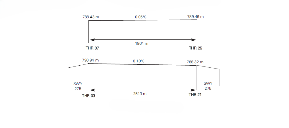
RUNWAY PHYSICAL CHARACTERISTICS
RWY |
TRUE BRG and MAG BRG |
DIM (m) |
THR PSN |
THR ELEV / TDZ ELEV |
SWY (m) |
CWY (m) |
Strip (m) |
OFZ |
RESA (m) |
RWY/SWY SFC PCN |
|---|---|---|---|---|---|---|---|---|---|---|
03 |
027.90°GEO 028°MAG |
2513 x 45 |
405631.29N 0053032.53W |
THR: 791 m/2595 ft / TDZ: No |
275 x 45 |
No |
2788 x 45 |
No |
No |
RWY: ASPH PCN 98/F/A/W/T SWY: Info no AVBL |
21 |
207.91°GEO 208°MAG |
2513 x 45 |
405743.29N 0052942.23W |
THR: 788 m/2586 ft / TDZ: Info not AVBL |
275 x 45 |
No |
2788 x 45 |
No |
No |
RWY: ASPH PCN 98/F/A/W/T SWY: Info no AVBL |
07 (1) |
074.10°GEO 074°MAG |
1864 x 122 |
405659.89N 0053043.15W |
THR: 788 m/2587 ft / TDZ: No |
No |
No |
No |
No |
No |
RWY: Hard soil 10000 kg SIWL 6.0 kg/cm² SWY: No |
25 (1) |
254.11°GEO 254°MAG |
1864 x 122 |
405716.44N 0052926.48W |
THR: 789 m/2590 ft / TDZ: No |
No |
No |
No |
No |
No |
RWY: Hard soil 10000 kg SIWL 6.0 kg/cm² SWY: No |
Remarks: (1) Military use only. |
||||||||||
profile
DECLARED DISTANCES
RWY |
TORA (m) |
TODA (m) |
ASDA (m) |
LDA (m) |
|---|---|---|---|---|
03 |
2513 |
2513 |
2788 |
2513 |
21 |
2513 |
2513 |
2788 |
2513 |
07 |
1864 |
1864 |
1864 |
1864 |
25 |
1864 |
1864 |
1864 |
1864 |
Remarks: None. |
||||
APPROACH AND RUNWAY LIGHTING
|
Runway | 03 |
Approach |
Simple, 420 m. Threshold identification lights. LIM. |
|
PAPI |
3°. |
|
Threshold |
Green. LIH. |
|
Touchdown zone |
No. |
|
Runway centre line |
No. |
|
Runway edge |
2513 m: 1913 m white + 600 m yellow. LIH. Distance between lights: 60 m. |
|
Runway end |
Red. LIH. |
|
Stopway |
No. |
|
Remarks |
None. |
|
Runway | 21 |
Approach |
Simple, 420 m. Threshold identification lights. LIM. |
|
PAPI (MEHT) |
3° (20 m / 66 ft). |
|
Threshold |
Green. LIH. |
|
Touchdown zone |
No. |
|
Runway centre line |
No. |
|
Runway edge |
2513 m: 1913 m white + 600 m yellow. LIH. Distance between lights: 60 m. |
|
Runway end |
Red. LIH. |
|
Stopway |
No. |
|
Remarks |
None. |
|
Runway | 07 |
Approach |
No. |
|
VASIS/PAPI |
No. |
|
Threshold |
No. |
|
Touchdown zone |
No. |
|
Runway centre line |
No. |
|
Runway edge |
No. |
|
Runway end |
No. |
|
Stopway |
No. |
|
Remarks |
None. |
|
Runway | 25 |
Approach |
No. |
|
VASIS/PAPI |
No. |
|
Threshold |
No. |
|
Touchdown zone |
No. |
|
Runway centre line |
No. |
|
Runway edge |
No. |
|
Runway end |
No. |
|
Stopway |
No. |
|
Remarks |
None. |
OTHER LIGHTING, SECONDARY POWER SUPPLY
ABN |
ALTN FLG W/G EV 6s. O/R. 405642N 0052937W. |
|
WDI |
1 near THR 03 NO LGTD, 1 near THR 21 LGTD. |
|
TWY lighting |
Edge. |
|
Apron lighting |
CIV: Yes, with floodlights. MIL: Yes, with floodlights. |
|
Secondary power supply |
There are two standby generators that provide a switch-over time (light) of 55 seconds approximately. |
|
Remarks |
None. |
HELICOPTER LANDING AREA
Position |
Near TWR. |
|
Elevation |
Information not available. |
|
Dimensions, surface, maximum weight, marking |
Circle 25 m. Grass. |
|
Direction |
Information not available. |
|
Declared distances |
Information not available. |
|
Lighting |
Information not available. |
|
Remarks |
NOT USEABLE. |
AIR TRAFFIC SERVICES AIRSPACE ATS AIRSPACE
|
Designation | CTR SALAMANCA. |
Lateral limits |
Circle radius 7.5 NM centred on ARP. Extended 2.5 NM on the RWY 07 RCL direction, forming a 4 NM wide rectangle symmetric about the RCL extension. |
|
Vertical limits |
SFC – FL 100. |
|
Airspace class |
D. |
|
Unit Language |
Salamanca APP. ES/EN. |
|
Transition altitude |
1850 m / 6000 ft. |
|
Hours of applicability |
- |
|
Remarks |
None. |
|
Designation | ATZ SALAMANCA. |
Lateral limits |
Circle radius 8 km centred on ARP. (1) |
|
Vertical limits |
SFC – 3000 ft HGT. (2) |
|
Airspace class |
D. |
|
Unit Language |
Salamanca TWR. ES/EN. |
|
Transition altitude |
- |
|
Hours of applicability |
- |
|
Remarks |
(1) Or the ground visibility, whichever is lower. (2) Or up to the cloud ceiling, whichever is lower. |
AIR TRAFFIC SERVICES COMMUNICATION FACILITIESATS COMMUNICATION FACILITIES
Service |
Call sign |
FREQ |
HR |
Remarks |
|---|---|---|---|---|
APP |
Salamanca APP |
124.405 C |
HR MIL AD |
APP/L |
121.500 MHz |
HR MIL AD |
EMERG |
||
257.800 MHz |
HR MIL AD |
MIL |
||
140.100 MHz |
HR MIL AD |
Local MIL |
||
TWR |
Salamanca TWR |
118.105 C |
HR MIL AD |
- |
139.300 MHz |
HR MIL AD |
MIL |
||
243.000 MHz |
HR MIL AD |
EMERG |
||
121.855 C |
HR MIL AD |
GMC |
RADIO NAVIGATION AND LANDING AIDSRADIO NAVIGATION & LANDING FACILITIES
Facility (VAR) |
ID |
FREQ |
HR |
Coordinates |
DME ELEV |
Remarks |
|---|---|---|---|---|---|---|
VOR (0°W) |
BBI |
112.200 MHz |
H24 |
410100.1N 0052724.6W |
- |
At 40 NM AVBL BTN:
|
DME |
BBI |
CH 59X |
H24 |
410100.1N 0052724.9W |
900 m |
At 40 NM AVBL BTN:
|
LOC 21 ILS CAT (0°W) |
IALR |
110.100 MHz |
H24 |
405623.3N 0053038.1W |
- |
208° MAG / 280 m FM THR 03. Caution due to possible false fly-up indications BTN 6 NM and 4 NM BLW GP. |
GP 21 |
- |
334.400 MHz |
H24 |
405736.7N 0052953.1W |
- |
3°; RDH 16 m; at 300 m FM THR 21 & 124 m FM RCL to the right in APCH direction. |
ILS/DME 21 |
IALR |
CH 38X |
H24 |
405736.7N 0052953.1W |
795 m |
REF DME THR 21. |
TACAN (0°W) |
TSC |
CH 80X |
H24 |
405718.8N 0053008.9W |
810 m |
Unmonitored facility. |
LOCAL AERODROME REGULATIONSLOCAL REGULATIONS
CIVIL AIRCRAFT
Civil aircraft not based at Salamanca AD:
-
May be cleared to carry out practices of approaches, landing and take-off on Saturdays, Sundays and holidays prior request at least 72 hours in advance. Other days they will not be cleared.
-
May experience delays due to schools flight activity, except for public passenger transport commercial flights.
-
May operate outside operational hours, prior coordination, at least 60 minutes in advance, when performing domestic ambulance and/or organ transport flights.
- Operations outside HR CIV AD, except for public passenger transport commercial flights, must be requested from the operations office via e-mail to osalamanca@aena.es, at least 72 hours before the operation. The request must contain the following information:
- Flight number and aircraft operator.
- Flight type.
- Type of aircraft and registration.
- Date and time planned (arrival and/or departure).
- Origin and/or destination.
- Passenger manifiest.
- Authorization for the operation will be issued by the same means by which it was requested.
-
VFR flights may not be accomplished from Mondays to Fridays, other than public holidays, except for regular commercial flights.
-
School flights will not be cleared from Mondays to Fridays (except public holidays).
CREW STAY IN CIVIL AIRCRAFT
Except in cases of force majeure, crew may stay in the aircraft up to one hour after landing, and may not accede to it until two hours before estimated time of departure.
FOREIGN STATE/MILITARY AIRCRAFT
PPR request is mandatory at least 72 hours in advance. When transporting dangerous goods or special operational needs this will be requested at least three working days in advance.
STATE SECURITY FORCES AIRCRAFT, MILITARY AND OTHER STATE AIRCRAFT
State Security Forces, Military and other state aircraft may operate outside operational hours, prior coordination, sending the request via FAX MIL at least 60 minutes in advance. In the request they must indicate: parent unit, number of aircraft, plans, schedule and POC.
PROCEDURE FOR THE REQUEST OF FIRE CATEGORY ON DEMAND
Salamanca Airport provides civil category 5 SEI continuously and 6 and 7 on demand. To operate with category 6 or 7 companies must request this from the operations office via e-mail to osalamanca@aena.es, at least 72 hours before the operation. The request must contain the following information:
-
Flight number and aircraft operator.
-
Flight type.
-
Type of aircraft and registration.
-
Date and time planned (arrival and/or departure).
-
Origin and/or destination.
-
Passengers manifiest.
Confirmation of category 6 or 7 will be issued by the same means by which it was requested.
ENGINE TESTS
The engine tests for aircraft located on the civil apron, shall be carried out at the RWY 03 runway holding position or at RWY 21 runway holding position. The testing request shall be made to TWR, who shall determine at which of these points it must take place.
OPERATIONAL SAFETY REPORTS
Pilots/operator shall report to the airport as soon as possible about any accidents, incidents, occurrences or events which may have a potential operational impact and in which they have been involved or witnessed.
The aim of these reports is the compilation of the information in order to improve operational safety, independently of the compulsory report of the occurrence to the appropriate aeronautical authority. Data may be sent in any format, including at least the following information:
-
Date and time.
-
Site.
-
Parties involved (data used to identify vehicles, aircraft...involved).
-
Companies implicated.
-
Description of the facts.
-
Any other data considered relevant (e.g. lighting conditions, weather, phase of the operation such as take-off / landing / stopover, pavement conditions…).
Contact e-mail address of the airport, for the reception of operational safety reports, is the following: seguridad_operacional_slm@aena.es
In addition to notifying the airport by means of the indicated system, it is necessary to send at least basic data of the accident, incident, occurrence or event to the air traffic control service provider (ATC).
ARMS AND EXPLOSIVES INSPECTION SERVICE
For those passengers who are carrying arms and so that the control services necessary can be established, a request must be made at least 72 hours in advance, to osalamanca@aena.es
NOISE ABATEMENT PROCEDURES
No.
FLIGHT PROCEDURES
LOW VISIBILITY PROCEDURES (LVP)
Low Visibility Procedures (LVP) are not available at Salamanca airport.
AD TRAFFIC CIRCUIT
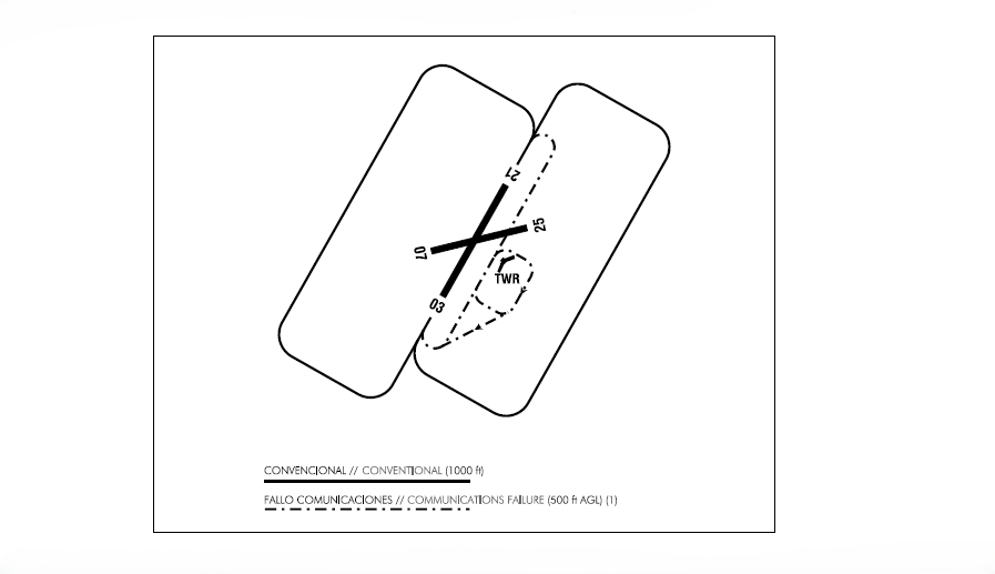
(1) Aircraft joining the communications failure circuit shall do so around the control tower, clockwise, maintaining appropriate safety distance from the runway and the main taxiway, and paying special attention to other aircraft which may be established in the visual circuits or making use of the runway.
ADDITIONAL INFORMATION
ARRESTING SYSTEMS
Nomenclature: LESA-01-R-U.
Type: NET BARRIER UNIDIRECTIONAL.
Location on RWY: RWY 21 THR + 2430 m / 7972 ft.
Readiness status: Permanently available on pilot request.
BIRD CONCENTRATION AREAS AND BIRD MOVEMENT IN THE VICINITY OF THE AD
The following bird concentration and passage areas can be identified near the airport compound:
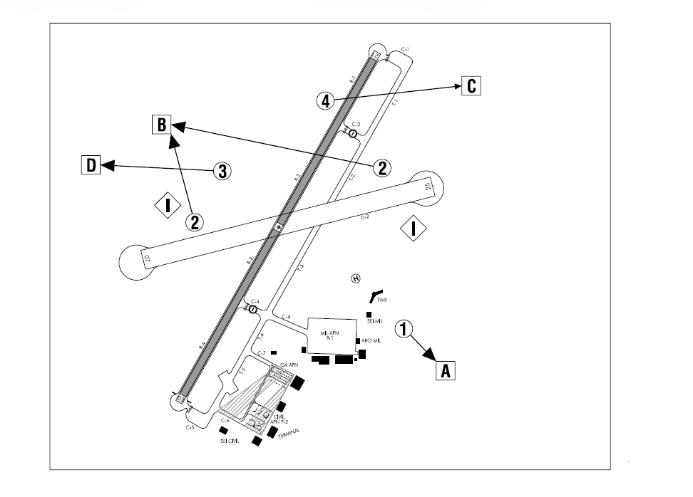
CONCENTRATION AREAS
Zone 1: concentration of pigeons.
Zone 2: concentration of starlings and lapwings (December-March).
Zone 3: concentration of crows.
Zone 4: concentration of common house martins (July-August).
FEEDING AREAS
Zone I: Crops areas.
BIRD MOVEMENT
Movement A: pigeons in flight.
Movement B: starlings and lapwings in flight.
Movement C: crows in flight.
Movement D: common house in flight.
POTENTIAL BIRD HAZARD AREAS
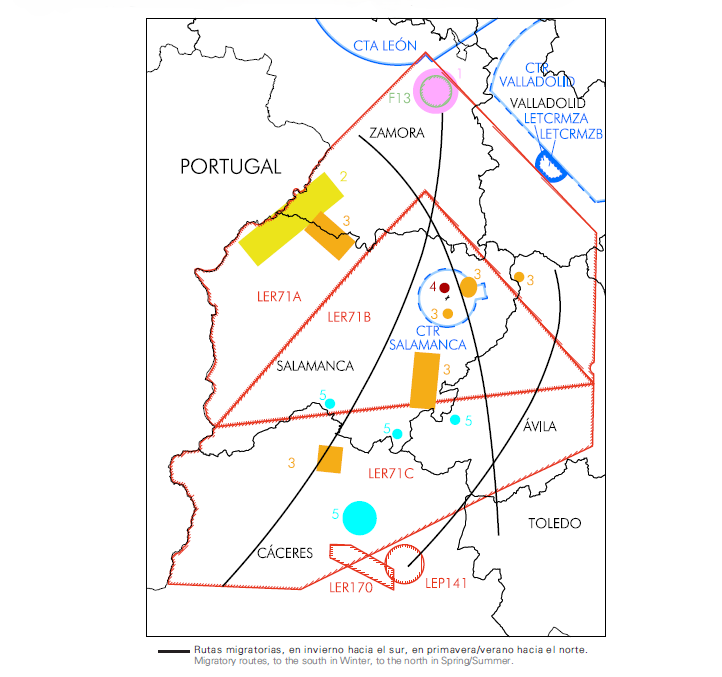
- Natural reserve: SFC-1000 ft AGL.
- Bustard (+6 kg)
- Goose (4 kg)
- Medium-sized raptors (1.5 kg)
- At sunrise and sunset below 1000 ft AGL; rest of the day above 1000 ft AGL.
- Black stork (+3 kg)
- Black griffon vulture (+10 kg)
- They can fly at heights above 1000 ft although they are usually at low altitudes.
- Crane (+6 kg)
- Gray heron (+2 kg)
- Cormorant (+3 kg)
- Ash Gull (+1 kg)
- Bustard (+6 kg)
- At mid and high altitudes all day.
- Stork (+3 kg)
- Griffon vulture (+8 kg)
- Black vulture (+10 kg)
- Seagull (+1 kg)
- Red kite (+1.5 kg)
- Heights above 1000 ft AGL.
- Black stork (+4 kg)
- Griffon vulture (+8 kg)
- Black vulture (+10 kg)
- Red kite (+1.5 kg)
AERONAUTICAL CHARTS RELATED TO AN AERODROMECHARTS RELATED TO THE AERODROME
The list of charts related to the aerodrome can be found on the link below:
VISUAL SEGMENT SURFACE (VSS) PENETRATION
Not applicable.