LEVD AD 2 AERODROME DATA
AERODROME LOCATION INDICATOR AND - NAME
LEVD - VALLADOLID/Villanubla
AERODROME GEOGRAPHICAL AND ADMINISTRATIVE DATA
ARP |
414222N 0045107W. See AD 2-LEVD ADC. |
|
Distance and direction from the city |
10 km NW. |
|
Elevation |
846 m / 2775 ft. |
|
Geoid undulation |
53.65 m ± 0.05 m. (1) |
|
Reference temperature |
29°C. |
|
Low average temperature |
3ºC. |
|
Magnetic variation |
1ºW (2020). |
|
Annual change |
8.5'E. |
|
AD administration |
Ejército del Aire y del Espacio. |
|
Address |
Base Aérea de Valladolid, Ctra. Adanero-Gijón km. 204; 47620 Villanubla (Valladolid). |
|
TEL |
CIV: +34-983 415 500; +34-983 415 503 (OPS). MIL: +34-983 368 400 |
|
| FAX | CIV: +34-983 415 513 MIL: +34-983 368 479 |
|
AFTN |
LEVD. |
|
CIV: OPS: vlloperaciones@aena.es |
||
Approved traffic |
IFR/VFR. |
|
Remarks |
(1) For all AD points. |
OPERATIONAL HOURS
Airport |
CIV: V: 0630-1915; I: 0730-2015. MIL: V: 0600-1915; I: 0700-2015. Other hours according to training periods. (1) |
|
Customs and Immigration |
HR AD. |
|
Health and Sanitation |
No. |
|
AIS/ARO/OPV |
HR AD. |
|
MET briefing |
HR AD PS 1 HR BFR. |
|
ATS |
HR AD. |
|
Fuelling |
CIV: HR AD. MIL: HR AD. |
|
Handling |
HR AD. |
|
Security |
H24. |
|
De-icing |
HR AD. |
|
Remarks |
(1) For foreign state/military aircraft is mandatory request PPR at least 72 hours in advance to:
|
HANDLING SERVICES AND FACILITIES
Cargo facilities |
CIV: No limitations. MIL: SATA CAT IV. Auxiliary cargo handling capabilities:
|
|
Fuel types |
CIV: JET A-1, 100LL. MIL: F-34. |
|
Oil types |
CIV: W100. MIL: G-354, G-395, H-573, O-156. |
|
Refuelling capacity |
CIV: JET A-1:
100LL:
MIL: F-34: Tanks 20000 L, 16.66 L/s. |
|
De-Icing facilities |
Yes (PRKG 0, 0A and 0B). |
|
Hangar space |
No. |
|
Repair facilities |
No. |
|
Remarks |
Thaw by GLICOL. MIL: GPU: Unit of AC (up to 100 KVA) and DC (up to 2600 A). Ramp agents:
Facilities for emptying aircraft holds:
|
PASSENGER FACILITIES
Hotels |
MIL: Yes. |
|
Restaurant |
Yes. |
|
Transportation |
CIV: Taxis and buses. MIL: Buses and light vehicles available on request. |
|
Medical facilities |
CIV: No. MIL: First aid and ambulance. |
|
Bank/Post Office |
No / No. |
|
Tourist information |
No. |
|
Remarks |
None. |
RESCUE AND FIREFIGHTING SERVICES
Fire category |
CIV: 7. MIL: 5. V: 0600-1915 (MON, TUE, WED, THU and FRI). I: 0700-2015 (MON, TUE, WED, THU and FRI). 4. V: 0600-1915 (SAT, SUN and holidays not Sunday). (1) I: 0700-2015 (SAT, SUN and holidays not Sunday). (1) From 01/07 to 30/09 and from 22/12 to 08/01. (1) |
|
Rescue equipment |
CIV/MIL: In accordance with the fire category published. |
|
Removal of disabled aircraft |
MIL: Equipment: LUNA RSL 45/9000-A with hook maximum capacity 30 TM. Low pressure bags up to 24 TM. |
|
Remarks |
(1) MIL category extendible to 5 with PPR 48 HR. |
RUNWAY SURFACE CONDITION ASSESSMENT AND REPORTING, AND SNOW PLAN
Equipment |
Lorry and tractor with snowplough spade and urea spreader. |
|
Priority |
RWY, TWY A, Civil apron, TWY T and C. |
|
Remarks |
Period of application: from 01-NOV to 30-APR. Iced / anti-iced of RWY 05/23, TWY and apron with urea. |
APRONS, TAXIWAYS AND CHECK LOCATIONS/POSITIONS DATAMOVEMENT AREA DETAILS
Apron |
Surface: Concrete. Strength: CIV: PCN 72/R/C/W/T. MIL: 20000 kg SIWL. |
|
Taxiways |
Width: 23 m, EXC A: 22.54 m. Surface: Concrete, EXC T4, T5, C6: asphalt. Strength: CIV: PCN 72/R/C/W/T. MIL: 30000 kg SIWL. |
|
Check locations |
Altimeter: Apron: CIV: 843 m / 2766 ft. MIL: 845 m / 2772 ft. VOR: No. INS: See AD 2-LEVD PDC 1.2. |
|
Remarks |
None. |
SURFACE MOVEMENT GUIDANCE AND CONTROL SYSTEM AND MARKINGSTAXIING GUIDANCE SYSTEM AND MARKINGS
Taxiing guidance system |
Boards, runway-holding positions, stands and stop bars. |
|
RWY markings |
Designators, threshold, centre line, side stripe, aiming point, touchdown zone and pre-threshold area. |
|
TWY markings |
Edge and centre line. |
|
Remarks |
None. |
AERODROME OBSTACLES
Obstacles in Approach, Take-Off Climb, Conical, Inner Horizontal, Transitional, Inner Transitional and Balked Landing Surfaces established in ICAO Annex 14; and the areas 2A and 3 established in ICAO Annex 15. Those penetrating these surfaces are identified in the CSV file as "Relevante_Relevant = Si/Yes". |
See Item 10 and Data Set.s section. |
|
Remarks |
See AD 2-LEVD AOC. |
METEOROLOGICAL INFORMATION PROVIDEDMETEOROLOGICAL SERVICE PROVIDED
MET office |
CIV: Valladolid OMD. MIL: Villanubla OMD. |
|
HR |
HR AD PS 1 HR BFR. Outside this schedule, a half-hourly METAR AUTO will be issued. |
|
METAR |
Hourly. |
|
TAF |
24HR. |
|
TREND |
Yes. |
|
Briefing |
In person and by telephone. |
|
Flight documentation/Language |
Charts and plain language / Spanish. |
|
Charts |
Significant forecasted, wind and temperature in altitude maps. |
|
Supplementary equipment |
Aeronautical meteorological self-service and cloud images, lightning and radar information display. |
|
ATS unit served |
TWR, OPV, APP. |
|
Additional information |
Madrid OMAe (LEMC): H24
MET office Valladolid: HR AD
|
|
Remarks |
Aerodrome climatological summary available. Aerodrome warnings available. |
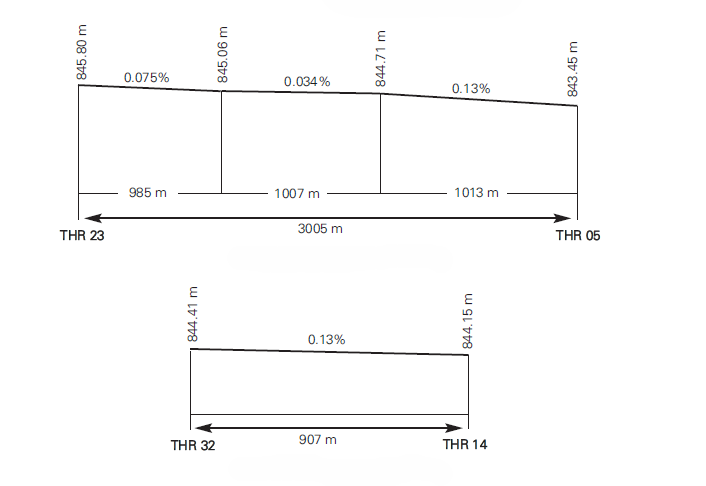
RUNWAY PHYSICAL CHARACTERISTICS
RWY |
Direction |
DIM (m) |
THR PSN |
THR ELEV TDZ ELEV |
SWY (m) |
CWY (m) |
Strip (m) |
OFZ |
RESA (m) |
RWY/SWY SFC PCN |
|---|---|---|---|---|---|---|---|---|---|---|
05 |
045.48° GEO 046° MAG |
3005 x 45 |
414149.27N 0045153.12W |
THR: 843 m / 2767 ft TDZ: No |
50 x 45 (2) |
300 x 150 |
3125 x 280 (3) |
No |
90 x 120 |
RWY: ASPH PCN 100/F/A/W/T SWY: Asphaltic concrete PCN: INFO NO AVBL |
23 |
225.50° GEO 226° MAG |
3005 x 45 |
414257.56N 0045020.42W |
THR: 845.8 m / 2775 ft TDZ: 845.8 m / 2775 ft |
206 x 45 (2) |
206 x 150 |
3125 x 280 (3) |
Yes |
90 x 120 |
RWY: ASPH PCN 100/F/A/W/T SWY: Hydraulic concrete PCN: INFO NO AVBL |
14 (1) |
144.06° GEO 145° MAG |
907 x 60 |
414247.94N 0045142.52W |
THR: 844 m / 2769 ft TDZ: No |
200 x 65 |
600 x 300 |
950 x 250 |
No |
No |
RWY: Hard soil 10000 kg SIWL 6.0 kg/cm2 SWY: INFO NO AVBL |
32 (1) |
324.06° GEO 325° MAG |
907 x 60 |
414224.14N 0045119.50W |
THR: 844 m / 2770 ft TDZ: No |
65 x 65 |
550 x 300 |
950 x 250 |
No |
No |
RWY: Hard soil 10000 kg SIWL 6.0 kg/cm2 SWY: INFO NO AVBL |
Remarks: (1) RWY 14/32 military use only. (2) SWY RWY 05/23 military use only. (3) First 579 m RWY 05 right side: strip 290 m. |
||||||||||
Profile
DECLARED DISTANCES
RWY |
TORA (m) |
TODA (m) |
ASDA (m) |
LDA (m) |
|---|---|---|---|---|
05 |
3005 |
3305 |
3005 (1) |
3005 |
23 |
3005 |
3211 |
3005 (2) |
3005 |
14 |
907 |
1507 |
1107 |
907 |
32 |
907 |
1457 |
972 |
907 |
Remarks: (1) ASDA MIL: 3055. (2) ASDA MIL: 3211. |
||||
APPROACH AND RUNWAY LIGHTING
Runway |
05 |
|
Approach |
No. |
|
PAPI (MEHT) |
3º (16.34 m/54 ft). |
|
Threshold |
Green with wing bars. |
|
Touchdown zone |
No. |
|
Runway centre line |
3005 m: 2105 m white + 600 m white and red + 300 m red. LIH. Distance between lights: 15 m. |
|
Runway edge |
3005 m: 2405 m white + 600 m yellow. LIH. Distance between lights: 60 m. |
|
Runway end |
Red. LIH. Distance between lights: 6 m. |
|
Stopway |
No. |
|
Remarks |
None. |
Runway |
23 |
|
Approach |
Precision CAT II/III 420 m. Runway lead-in lighting system (120). |
|
PAPI (MEHT) |
3º (16.15 m/53 ft). |
|
Threshold |
Green with wing bars. |
|
Touchdown zone |
900 m white. |
|
Runway centre line |
3005 m: 2105 m white + 600 m white and red + 300 m red. LIH. Distance between lights: 15 m. |
|
Runway edge |
3005 m: 2405 m white + 600 m yellow. LIH. Distance between lights: 60 m. |
|
Runway end |
Red. LIH. Distance between lights: 6 m. |
|
Stopway |
No. |
|
Remarks |
None. |
Runway |
14 |
|
Approach |
No. |
|
VASIS/PAPI |
No. |
|
Threshold |
No. |
|
Touchdown zone |
No. |
|
Runway centre line |
No. |
|
Runway edge |
No. |
|
Runway end |
No. |
|
Stopway |
No. |
|
Remarks |
None. |
Runway |
32 |
|
Approach |
No. |
|
VASIS/PAPI |
No. |
|
Threshold |
No. |
|
Touchdown zone |
No. |
|
Runway centre line |
No. |
|
Runway edge |
No. |
|
Runway end |
No. |
|
Stopway |
No. |
|
Remarks |
None. |
OTHER LIGHTING, SECONDARY POWER SUPPLY
ABN/IBN |
No. |
|
WDI |
1 near THR 05. 1 near THR 23. 1 near CIV apron. LGTD. 1 near MIL apron no LGTD. |
|
TWY lighting |
Edge and centre line. EXC: C-2, C-3 and C-5 edge. |
|
Apron lighting |
Floodlighting poles, edge. |
|
Secondary power supply |
Engine generators that provide a switch-over time (light) for CAT II/III according to Annex 14. |
|
Remarks |
None. |
HELICOPTER LANDING AREA
Position |
No. |
|
Elevation |
No. |
|
Dimensions, surface, maximum weight, marking |
No. |
|
Direction |
No. |
|
Declared distances |
No. |
|
Lighting |
No. |
|
Remarks |
None. |
AIR TRAFFIC SERVICES AIRSPACE ATS AIRSPACE
Designation |
CTR VALLADOLID. |
|
Lateral limits |
415025N 0051733W, circular sector radius 25 NM centred on 414722N 0044421W to 412229N 0044039W, 415025N 0051733W. |
|
Vertical limits |
SFC - FL100. |
|
Airspace class |
D. |
|
Unit Language |
VALLADOLID TWR. ES/EN. |
|
Transition altitude |
1850 m / 6000 ft. |
|
Hours of applicability |
- |
|
Remarks |
None. |
Designation |
ATZ VALLADOLID. |
|
Lateral limits |
Circle radius 8 km centred on ARP. (1) |
|
Vertical limits |
SFC - 3000 ft HGT. (2) |
|
Airspace class |
D. |
|
Unit Language |
VALLADOLID TWR. ES/EN. |
|
Transition altitude |
- |
|
Hours of applicability |
- |
|
Remarks |
(1) Or the ground visibility, whichever is lower. (2) Or up to the cloud ceiling, whichever is lower. |
AIR TRAFFIC SERVICES COMMUNICATION FACILITIESATS COMMUNICATION FACILITIES
Service |
Call sign |
FREQ |
HR |
Remarks |
|---|---|---|---|---|
APP/TWR |
Valladolid TWR |
122.205 C |
HR AD |
APP/L |
121.500 MHz |
HR AD |
EMERG |
||
139.300 MHz |
HR AD |
MIL |
||
139.700 MHz |
HR AD |
MIL |
||
243.000 MHz |
HR AD |
EMERG |
||
257.800 MHz |
HR AD |
MIL |
RADIO NAVIGATION AND LANDING AIDSRADIO NAVIGATION & LANDING FACILITIES
Facility (VAR) |
ID |
FREQ |
HR |
Coordinates |
DME ELEV |
Remarks |
|---|---|---|---|---|---|---|
VOR |
NUB |
113.650 MHz |
H24 |
414219.2N 0045103.3W |
- |
- |
DME |
NUB |
CH 83Y |
H24 |
414219.2N 0045103.3W |
840 m |
- |
LOC 23 ILS CAT II/III (1ºW) |
IVD |
109.300 MHz |
H24 |
414143.5N 0045201.0W |
- |
226º MAG / 256 m FM THR 05. |
GP 23 |
- |
332.000 MHz |
H24 |
414247.5N 0045026.7W |
- |
3°; RDH 16.65 m; at 323 m FM THR 23 & 120 m FM RCL to the left in APCH direction. |
ILS/DME |
IVD |
CH 30X |
H24 |
414247.5N 0045026.7W |
852 m |
REF DME THR 23. |
LOCAL AERODROME REGULATIONSLOCAL REGULATIONS
Parachute jumping and dropping exercises will take place periodically. Relevant information will be published by NOTAM in advance.
RESTRICTIONS TO OPERATIONS
No civil aircraft (IFR/VFR) will be cleared to practise approaches or touch-and-goes. Landing will be authorised only if a flight plan with destination LEVD is approved.
EXTENSION OF OPERATING HOURS
Request to extend civil Operating Hours will be submitted by companies or aircraft operators to the delegate of Aena in Villanubla Air Base at least four days in advance. For regular companies operating from or to Villanubla, delayed for reasons not attributable to them, they may submit the request to extend operating hours at least two hours in advance.
ILS CATEGORY II AND III OPERATIONS
RWY 23, subject to service availability of the appropriate approach and landing aids, is suitable for carrying out CAT II and III operations by air operators whose operational minima has been approved by the aeronautical civil authority.
OPERATIONAL SAFETY REPORTS
Pilots/operator shall report to the airport as soon as possible any accidents, incidents, occurrences or events that may have a potential operational impact and in which they have been involved or witnessed.
The aim of these reports is to compile the information in order to improve operational safety, independently of the compulsory report of the occurrence to the appropriate aeronautical authority. Data may be sent in any format, including at least the following information:
-
Date and time.
-
Site.
-
Parties involved (data used to identify vehicles, aircraft...involved).
-
Companies involved.
-
Description of facts.
-
Any other data considered relevant (e.g. lighting conditions, weather, operational phase, such as take-off / landing / stopover, pavement conditions…).
The contact e-mail address of the airport, for receipt of operational safety reports, is the following: Seguridad_Operacional_VLL@aena.es
In addition to notifying the airport by means of the indicated system, it is necessary to send at least basic data on the accident, incident, occurrence or event to the air traffic control service provider (ATC).
NOISE ABATEMENT PROCEDURES
No.
FLIGHT PROCEDURES
LOW VISIBILITY PROCEDURES (LVP)
GENERAL
RWY 23 is equipped with ILS CAT II/III and authorised for CAT III approach.
RWY 05/23 is authorised for use for take-off in low visibility conditions, LVTO.
CRITERIA FOR APPLICATION AND CANCELLATION OF PROCEDURES
Low Visibility Procedures shall apply when the RVR value or general visibility, if RVR is out of service, is 1000 m or below or the cloud ceiling is below 75 m.
Low Visibility Procedures shall end when:
- RVR value is higher than 1000 m, the cloud ceiling is 90 m or above for at least 10 minutes and the improvement trend for the meteorological conditions is strong.
- Application of the procedure shall be suspended when there are no operations in progress or planned that require application of the LVP.
DETAILS OF ENTRIES TO RUNWAY
For runway access, aircraft shall proceed depending on the runway in use:
- THR 23:
-
For aircraft leaving the civil apron: exit the apron by TWY A, cross the runway, follow TWY C-4, T-4 and T-5 until C-6.
- For aircraft leaving the military apron: follow TWY T-4 and T-5 until C-6.
- THR 05:
-
For aircraft leaving the civil apron: exit the apron by TWY A, cross the runway, follow TWY C-4, T-3, T-2 and T-1 until C-1.
-
For aircraft leaving the military apron: follow TWY C-1-1, T-2 and T-1 until C-1.
When vacating the runway, civil aircraft that have already landed will vacate runway in use by TWY C-1, following the parallel TWY until C-4, crossing the runway and following TWY A until the civil apron. While LVP procedures are activated, TWY C-2, C-3 and C-5 will be closed. In the case of military aircraft, the runway in use shall be vacated by TWY C-1 following parallel TWY until C-1-1 to the military apron.
DETAILS OF HOLDING POINTS AVAILABLE
The runway holding points corresponding to the threshold of each runway will be used.
GROUND MOVEMENT RESTRICTIONS
Usually, while the low visibility procedures are in force, the movement of only one aircraft will be authorised by TWR.
Pilots shall verify the aircraft position at all times, especially at intersections, checking that taxiing is being conducted under complete safety conditions. In case of disorientation or when in doubt, pilots shall stop the aircraft and immediately notify the TWR.
The "Follow me" vehicle in the civil area shall accompany the aircraft between the stand and C-1 or C-6 via TWY, and vice versa, if the pilot has requested this service.
During Low Visibility Procedures, apron safety rules shall be respected with special attention. Passengers boarding and debarking shall use a bus. Failing that, the handling agent must guide passengers through pedestrian paths and service roads available for such purpose. In both cases, security regulations shall be observed with special attention.
LOW VISIBILITY PROCEDURE DESCRIPTION
General
Pilots will be informed of the application of the Low Visibility Procedures by radiotelephone. Any incident affecting LVP will be communicated immediately.
The integrated system at the meteorology office will provide runway visual range (RVR) values directly as follows:
-
RVR ALPHA: figures corresponding to the touchdown zone.
-
RVR BRAVO: figures corresponding to the runway mid-point.
-
RVR CHARLIE: runway end figures.
CAT II/III approach and landing.
Landing clearance shall not be granted after the aircraft is located 2 NM from TDZ. If that is not possible, instructions shall be given to execute the missed approach manoeuvre. When CAT II/III approaches are executed, landing clearance shall be granted only when the sensitive areas of ILS (LSA) are cleared.
Departures with low visibility.
-
RWY 05/23 are appropriately suited for take-off in low visibility conditions, according to the aerodrome's operational tables of minima, appendix 1 OPS 1.430 and will be interpreted with the criteria and exceptions of this document.
-
The minima for departure (RWY 05/23) shall be established by each operator.
-
TWR will inform the pilots of the application of the Low Visibility Procedures.
-
Pilots shall request engine start-up from TWR with RVR figures equal to or greater than their departure minima.
-
In case of disorientation, pilots shall stop the aircraft and notify the TWR immediately.
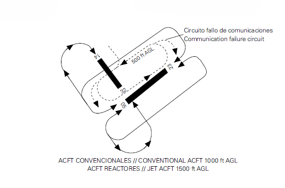
COMMUNICATIONS FAILURE
If an aircraft or vehicle has a communication failure in the manoeuvres area, the following procedure shall apply:
-
If it is a departing aircraft, it shall continue on the assigned route until the clearance limit, taking care to avoid deflection and maintaining position and awaiting the arrival of a "Follow me" vehicle, which will provide guidance until the stand position or the assigned holding bay.
-
If it is an arriving aircraft, it shall hold its position in the first segment of the taxiway in which the ILS sensitive area is cleared and awaiting the arrival of a "Follow me" vehicle, which will provide guidance until the assigned stand position.
-
If it is a vehicle, it shall hold its position and await the arrival of a "Follow me" vehicle, which will provide guidance to the assigned point. If the communications failure occurs while crossing or remaining on a RWY, it shall vacate the RWY as soon as possible, stopping the vehicle off the runway and awaiting the arrival of a "Follow me" vehicle.
AD TRAFFIC CIRCUIT
ADDITIONAL INFORMATION
No.
AERONAUTICAL CHARTS RELATED TO AN AERODROMECHARTS RELATED TO THE AERODROME
The list of charts related to the aerodrome can be found on the link below:
VISUAL SEGMENT SURFACE (VSS) PENETRATION
Not applicable.