LEXJ AD 2 AERODROME DATA
AERODROME LOCATION INDICATOR AND - NAME
LEXJ - SANTANDER/Seve Ballesteros-Santander
AERODROME GEOGRAPHICAL AND ADMINISTRATIVE DATA
ARP |
432537N 0034912W. See AD 2-LEXJ ADC. |
|
Distance and direction from the city |
4 km S. |
|
Elevation |
5 m / 16 ft. |
|
Geoid undulation |
50.12 m ± 0.05 m (1). |
|
Reference temperature |
24°C. |
|
Low average temperature |
9ºC. |
|
Magnetic variation |
0º (2025). |
|
Annual change |
10'E. |
|
AD administration |
Aena. |
|
Address |
Aeropuerto de SANTANDER/Seve Ballesteros-Santander; 39600 Maliaño (Cantabria). |
|
TEL |
+34-942 202 113/111 |
|
|
FAX |
+34-942 202 153 |
AFTN |
LEXJ |
|
Approved traffic |
IFR/VFR. (2) |
|
Remarks |
Payment of airport fees shall be accomplished by electronic means (payment card or virtual TPV) or by the exact sum in cash (maximum amount of 1000 euros). (1) For all AD points. (2) Business and General Aviation: see item 20. |
OPERATIONAL HOURS
Airport |
V: 0430-2100, PS 2 HR PPR. I: 0530-2200, PS 2 HR PPR. |
|
Customs and Immigration |
HR AD. (1) |
|
Health and Sanitation |
See GEN 1.4. |
|
AIS |
H24. (2) |
|
ARO |
HR AD. (3) |
|
MET briefing |
V: 0330-2100, PS 2HR PPR. I: 0430-2200, PS 2HR PPR. |
|
ATS |
V: 0415-2120, I: 0515-2220. In case PPR is activated: V: 0415-2320, I: 0515-0020. |
|
Fuelling |
HR AD. |
|
Handling |
HR AD. |
|
Security |
H24. |
|
De-icing |
No. |
|
Remarks |
Airport hours of activity: V: 0415-2120, I: 0515-2220. In case PPR is activated: V: 0415-2320, I: 0515-0020. (1) Except for scheduled commercial flights and before submitting the flight plan, the operation must be communicated 1 HR in advance to the Airport Operations Centre (CEOPS):
(2) Centralised AIO Office - International NOTAM Office
(3) ARO service provided from the operations office of the airport. |
HANDLING SERVICES AND FACILITIES
Cargo facilities |
Yes. |
|
Fuel types |
100LL, JET A-1. |
|
Oil types |
AEROSHELL W100. |
|
Refuelling capacity |
100LL:
JET A-1:
|
|
De-Icing facilities |
Hot water and glicol for removing ice from the ACFT in stand. Service provided by handling agent. |
|
Hangar space |
No. |
|
Repair facilities |
No. |
|
Remarks |
Request for fuel supply: EXOLUM
Commercial Aviation and General Aviation handling agent:
General Aviation handling agent:
|
PASSENGER FACILITIES
Hotels |
No. |
|
Restaurant |
Yes. |
|
Transportation |
Bus, taxis and hire cars. |
|
Medical facilities |
No. |
|
Bank/Post Office |
Banking machine/Mail box. |
|
Tourist information |
Yes. |
|
Remarks |
None. |
RESCUE AND FIREFIGHTING SERVICES
Fire category |
7. (1) |
|
Rescue equipment |
In accordance with the fire category published. |
|
Removal of disabled aircraft |
Own equipment for removing disabled aircraft up to 2 TM. For heavier aircraft, external service subject to presence and at the expense of the aircraft owner/operator. (2) |
|
Remarks |
(1) The response time of the rescue and fire fighting service is less than 3 minutes, with an operational objective of less than 2 minutes. Fire category 8 on demand, according to PROCEDURE FOR OPERATION OF AIRCRAFT EXCEEDING THE CERTIFIED AERODROME CHARACTERISTICS (see item 20). (2) Responsible for coordinating the removal operation for disabled aircraft: CEOPS (Airport Operations Centre). The contact data appear in item 2. |
RUNWAY SURFACE CONDITION ASSESSMENT AND REPORTING, AND SNOW PLAN
Types of clearing equipment |
Urea spreader, snowplough. |
|
Clearance priorities |
Runway, runway access taxiway Y2, apron access B, parking apron access taxiway B and stands 01 to 04. |
|
Use of material for movement area surface treatment |
Urea (UREA). |
|
Specially prepared winter runways |
Not applicable. |
|
Remarks |
Period of application of snow plan: 01-DEC to 31-MAR. Runway surface condition assessment and reporting in accordance with the Global Reporting Format (GRF) methodology described in AD 1.2.2. Aerodrome in service during all seasons of the year. |
APRONS, TAXIWAYS AND CHECK LOCATIONS/POSITIONS DATAMOVEMENT AREA DETAILS
Apron |
Surface: Concrete. EXC PRKG 23: Asphaltic concrete. Strength: PRKG FM 1 TO 8: PCN 63/R/B/W/T. PRKG FM 9 TO 13: PCN 79/R/B/W/T. PRKG FM 14 TO 24: PCN 136/R/B/W/T. |
|
Taxiways |
Width: 23 m. Surface: Asphalt. Strength: PCN 102/F/A/W/T. |
|
Check locations |
Altimeter: Apron ELEV 3 m / 10 ft. VOR: No. INS: See AD 2-LEXJ PDC. |
|
Remarks |
None. |
SURFACE MOVEMENT GUIDANCE AND CONTROL SYSTEM AND MARKINGSTAXIING GUIDANCE SYSTEM AND MARKINGS
Taxiing guidance system |
Runway-holding positions, runway guard lights, intermediate holding positions, stop bars, LGTD boards and stands. |
|
RWY markings |
Designators, threshold, turning bay, centre line, side stripe, aiming point, touchdown zone. |
|
TWY markings |
Centre line, edge. |
|
Remarks |
None. |
AERODROME OBSTACLES
Obstacles in Approach, Take-Off Climb, Conical, Inner Horizontal, Transitional, Inner Transitional and Balked Landing Surfaces established in ICAO Annex 14; and the areas 2A and 3 established in ICAO Annex 15. Those penetrating these surfaces are identified in the CSV file as "Relevante_Relevant = Si/Yes". |
See Item 10 and Digital Data sectionData Set. |
|
Remarks |
See AD 2-LEXJ AOC. |
METEOROLOGICAL INFORMATION PROVIDEDMETEOROLOGICAL SERVICE PROVIDED
MET office |
Santander EMAe. |
|
HR |
V: 0330-2100, PS 2HR PPR. I: 0430-2200, PS 2HR PPR. Outside these hours, a half-hourly METAR AUTO will be issued. |
|
METAR |
Half-hourly. |
|
TAF |
24 HR. |
|
TREND |
No. |
|
Briefing |
In person and by telephone. |
|
Flight documentation/Language |
Charts and plain language/Spanish. |
|
Charts |
Forecasted significant and wind and temperature in altitude map. |
|
Supplementary equipment |
Cloud, lightning image and radar information display. |
|
ATS unit served |
TWR. |
|
Additional information |
Santander OMAe (LESD): H24
Santander EMAe: HR AD
|
|
Remarks |
Aerodrome climatological summary available. Aerodrome warnings available. There is a meteorological station sited at 4329N 00348W. Which launches observation balloons twice daily, between 1115 and 1130 and between 2315 and 2330. See ENR 5.3. |
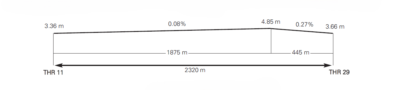
RUNWAY PHYSICAL CHARACTERISTICS
RWY |
Direction |
DIM (m) |
THR PSN |
THR ELEV |
SWY (m) |
CWY (m) |
Strip (m) |
OFZ |
RESA (m) |
RWY/SWY SFC |
|---|---|---|---|---|---|---|---|---|---|---|
11 |
110.12° GEO |
2320 x 45 |
432550.8436N 0035002.1062W |
THR: 3.4 m / 11 ft |
No |
60 x 150 |
2440 x 300 |
No |
90 x 90 |
RWY: ASPH (1) |
29 |
290.15° GEO |
2320 x 45 |
432524.9536N 0034825.2462W |
THR: 3.7 m / 12 ft |
No |
60 x 150 |
2440 x 300 |
No |
90 x 90 |
RWY: ASPH (2) |
Remarks: (1) Concrete first 200 m of RWY 11. PCN 71/R/C/W/T. (2) Concrete first 120 m of RWY 29. PCN 71/R/C/W/T. |
||||||||||
Profile
DECLARED DISTANCES
RWY |
TORA (m) |
TODA (m) |
ASDA (m) |
LDA (m) |
|---|---|---|---|---|
11 |
2320 |
2380 |
2320 |
2320 |
29 |
2320 |
2380 |
2320 |
2320 |
11 INT Y2 (1) |
1312 |
1372 |
1312 |
- |
11 INT Y3 |
1943 |
2003 |
1943 |
- |
29 INT Y1 |
1833 |
1893 |
1833 |
- |
29 INT Y2 (1) |
1030 |
1090 |
1030 |
- |
Remarks: (1) Helicopters exclusive use only. |
||||
APPROACH AND RUNWAY LIGHTING
Runway |
11 |
|
Approach |
Threshold identification lights. LIH |
|
|
PAPI (MEHT) |
3° (16.38 m/54 ft). |
Threshold |
Green, with wing bars. |
|
Touchdown zone |
No. |
|
Runway centreline |
2320 m: 1420 m white + 600 m white and red + 300 m red. LIH. Regulable luminosity. Distance between lights: 15 m. |
|
Runway edge |
2320 m: 1720 m white + 600 m yellow. Regulable luminosity. LIH. Distance between lights: 50 m. |
|
Runway end |
Red. |
|
Stopway |
No. |
|
Remarks |
Turning pad centreline: 43 green markers. Turning pad edge: LED lighting. |
Runway |
29 |
|
Approach |
Precision CAT I, 300 m. (1) Threshold identification lights. LIH. |
|
|
PAPI (MEHT) |
3° (16.51 m/54 ft). |
Threshold |
Green, with wing bars. |
|
Touchdown zone |
No. |
|
Runway centreline |
2320 m: 1420 m white + 600 m white and red + 300 m red. LIH. Regulable luminosity. Distance between lights: 15 m. |
|
Runway edge |
2320 m: 1720 m white + 600 m yellow. Regulable luminosity. LIH. Distance between lights: 50 m. |
|
Runway end |
Red. |
|
Stopway |
No. |
|
Remarks |
Turning pad centreline: 39 green markers. Turning pad edge: LED lighting. (1) LED lighting. |
OTHER LIGHTING, SECONDARY POWER SUPPLY
ABN/IBN |
No. |
|
WDI |
1 near THR 11, 1 near THR 29, 1 near apron. LGTD. |
|
TWY lighting |
Edge and centreline. |
|
Apron lighting |
Edge (1), 4 floodlighting poles. LIH (2). |
|
Secondary power supply |
The maximum switch-over (light) time is 1 second for the runway centre line, runway edge, threshold, runway end and stop bars. For the remaining visual aids systems, the maximum switch-over (light) time established is 15 seconds. |
|
Remarks |
(1) LED lighting. (2) Partial LED lighting (50%). |
HELICOPTER LANDING AREA
Position |
FATO: RWY 11/29. Coordinates THR 11 and THR 29, see item 12. Ground taxiing: TLOF same as RWY 11/29. Coordinates: 432537N 0034912W (same as ARP). Air taxiing: TLOF same as PRKG 23 and 24. |
|
Elevation |
FATO: RWY 11/29. Elevation THR 11 and THR 29, see item 12. Ground taxiing: TLOF same as RWY 11/29. Elevation: 5 m. Air taxiing: TLOF same as PRKG
|
|
Dimensions, surface, maximum weight, marking |
FATO: RWY 11/29. Ground taxiing: TLOF same as RWY 11/29, see item 12. Air taxiing: TLOF same as PRKG
Circular strip 30 cm wide with inner diameter of 17.85 m. |
|
Directions |
No. |
|
Declared distances |
Yes. See AD 2-LEXJ item 20, HELICOPTER OPERATIONS. |
|
Lighting |
No. |
|
Remarks |
Air taxiing: Maximum speed: 37 km/h. Lighting for TWY D-2, and PRKG 23 and 24: No. |
AIR TRAFFIC SERVICES AIRSPACEATS AIRSPACE
Designation |
CTR SANTANDER. |
|
Lateral limits |
433128N 0040036W; 432913N 0034546W; 432833N 0034316W; 433025N 0033707W; 432457N 0033224W; 431823N 0033522W; 432646N 0040256W; 433128N 0040036W. |
|
Vertical limits |
SFC - 1000 ft AGL. |
|
Airspace class |
D. |
|
Unit |
SANTANDER TWR. ES/EN. |
|
Transition altitude |
1850 m/6000 ft. |
|
Hours of applicability |
- |
|
Remarks |
- |
Designation |
ATZ SANTANDER. |
|
Lateral limits |
Circle radius 8 km centred on ARP. (1) |
|
Vertical limits |
SFC - 3000 ft HGT (2). |
|
Airspace class |
D. |
|
Unit |
SANTANDER TWR. ES/EN. |
|
Transition altitude |
- |
|
Hours of applicability |
- |
|
Remarks |
(1) Or the ground visibility, whichever is lower. (2) Or up to the cloud ceiling, whichever is lower. |
AIR TRAFFIC SERVICES COMMUNICATION FACILITIESATS COMMUNICATION FACILITIES
Service |
Call sign |
FREQ |
HR |
Remarks |
|---|---|---|---|---|
APP |
Santander TWR |
118.375 MHz |
HR ATS |
APP/I |
TWR |
Santander TWR |
118.105 C |
HR ATS |
- |
121.500 MHz |
HR ATS |
EMERG |
||
121.705 C |
HR ATS |
GMC |
||
257.800 MHz |
HR ATS |
MIL |
||
ATIS |
Santander Information |
127.530 C |
HR ATS |
- |
D-ATIS |
Santander Information |
NIL |
HR ATS |
Provision of ATIS information via data link. |
RADIO NAVIGATION AND LANDING AIDSRADIO NAVIGATION & LANDING FACILITIES
Facility (VAR) |
ID |
FREQ |
HR |
Coordinates |
DME ELEV |
Remarks |
|---|---|---|---|---|---|---|
DVOR (0ºW) |
SNR |
115.300 MHz |
H24 |
432659.2N 0035408.7W |
- |
COV 40 NM U/S BTN:
COV 10 NM:
|
DME |
SNR |
CH 100X |
H24 |
432659.7N 0035408.3W |
60 m |
COV 40 NM U/S BTN:
R-275 COV FL080 26.4 NM (RONSI), FL100 38 NM overlap with VES. |
NDB (0ºW) |
SA |
416.000 kHz |
H24 |
432606.2N 0035059.6W |
- |
COV 25 NM: Possible signal fluctuations BTN 119º/159º & 219º/249º. |
LOC 29 (0ºW) |
STA |
110.900 MHz |
H24 |
432553.0N 0035010.2W |
- |
290º MAG / 193 m FM THR 11. COV 17 NM AVBL BTN 20º to the left and 35º to the right of RCL to 5100 ft AMSL or ABV. COV 25 NM AVBL BTN +-10º of RCL to 5100 ft AMSL or ABV. |
GP 29 |
- |
330.800 MHz |
H24 |
432532.3N 0034836.7W |
- |
3°; RDH 17.7 m; at 320 m FM THR 29 & 125 m FM RCL to the right in direction APCH. Full fly-up indications may not be received BLW GP to the right of RCL. |
ILS/DME 29 |
STA |
CH 46X |
H24 |
432532.3N 0034836.7W |
9 m |
REF DME THR 29. |
LOCAL AERODROME REGULATIONSLOCAL REGULATIONS
AD closed to aircraft without two-way radio communication.
ATC PROCEDURES
MINIMUM RUNWAY OCCUPANCY TIME
Given that the taxiway parallel to the runway does not reach the thresholds, it is usually necessary to taxi along the runway. In this case, the following shall be taken into account:
-
DEPARTURES
Aircraft should be ready to initiate take-off immediately after alignment with the corresponding runway centre line. Pilots unable to comply with this requirement shall notify ATC before reaching the runway-holding positions at Y-1, Y-2 or T-3.
-
ARRIVALS
Commensurate with aircraft safety and standard operation, pilots are reminded that rapid exit from the runway enables maximum runway utilization and lessens its occupancy time.
TAKE-OFF FROM INTERSECTION
Aircraft requesting this procedure shall notify it, preferably, when requesting clearance to start-up.
STANDARD TAXIING PROCEDURES
TAXIING MANOEUVRES
-
Pilots shall request clearance from ATC to start-up engines/turbines on the appropriate frequency. When this clearance is requested, the aircraft must be ready to start up immediately, or expected to be ready to do so within a maximum period of 5 minutes.
-
All the stands are autonomous. Exits from these stands shall be carried out using the minimum start-up engine power and in such a way that, when making the turn, this is not higher than idling.
TAXIING RESTRICTIONS
Simultaneous use of the runway and the taxiway parallel to the runway are incompatible when one of them is being used by a type E aircraft.
GROUND MOVEMENT
Crossing the apron taxiways on foot is forbidden except when the aircraft does not have a ground handling agent, and shall be accomplished using the apron service roads, wearing high-visibility clothing, and with clearance from the movement area supervision service.
All surface movements of aircraft, towed aircraft, persons and vehicles in the manoeuvring area are subject to prior ATC clearance.
All movements of aircraft, towed aircraft, persons and vehicles on the apron shall be regulated by the Apron Safety Regulations.
Avoidance of collisions with other aircraft or obstacles is the responsibility of:
-
Pilots, when taxiing on the apron.
-
Ground handling companies during parking stand exit manoeuvres with push-back, and during towing.
RWY 29 IN USE
DEPARTURES
Aircraft shall exit the apron at GATE A, except:
-
In cases where, for operational reasons, the exit via GATE B is coordinated with the inspection service in the manoeuvring area (access road to apron parking is occupied by an aircraft that poses an obstacle to the entry manoeuvre, assigned parking, aircraft type, etc.).
Aircraft shall generally taxi on TWY T1 and Y1.
ARRIVALS
Aircraft shall exit via TWY Y2 or Y3 or Y4.
Aircraft shall enter the apron via GATE B, except in cases where, for operational reasons, entry via GATE A is coordinated with the inspection service in the manoeuvring area (access road to apron parking is occupied by an aircraft that poses an obstacle to the entry manoeuvre, assigned parking, aircraft type, etc.).
RWY 11 IN USE
DEPARTURES
Aircraft shall depart the apron at GATE B, except:
-
In cases where, for operational reasons, exit via GATE A is coordinated with the inspection service in the manoeuvring area (access road to apron parking is occupied by an aircraft that poses an obstacle to the entry manoeuvre, assigned parking, aircraft type, etc.).
Aircraft shall generally taxi on TWY T3 and Y4 or Y3.
ARRIVALS
Arriving aircraft shall exit via TWY Y2 or Y1.
Aircraft shall enter the apron via GATE A, except in cases where, for operational reasons, entry via GATE B is coordinated with the inspection service in the manoeuvring area (access road to apron parking is occupied by an aircraft that poses an obstacle to the entry manoeuvre, assigned parking, aircraft type, etc.).
For helicopter operations, consult item 20. LOCAL REGULATIONS - HELICOPTER OPERATIONS.
For operations of higher code letter aircraft, consult item 20. LOCAL REGULATIONS - OPERATING PROCEDURE FOR HIGHER CODE LETTER AIRCRAFT (D and E: A330-200)
GENERAL AND BUSINESS AVIATION
GENERAL
School and training operations (landing, touch-and-go, approach manoeuvre, low pass, etc.) shall be constrained by the operational possibilities, with the scheduled commercial activity at the airport being given priority.
The rates for financial contributions currently published by AENA will be applicable, section 2.1.5 Training and schools, to all operations including approach, low pass or touch-and-go manoeuvres.
GROUND HANDLING
In accordance with the provisions of AIP-Spain, section AD 1.1, point 1.3.1.6, it is mandatory to contract ground handling services for all operations, including non-commercial ones, whose passengers and/or crew members must access to the terminal building.
The minimum services to be contracted are as follows:
-
Complementary ramp service for the transport of passengers and/or crew members between the aircraft and the terminal building.
-
Additionally, if the operation originates from or is destined to a non-Schengen airport, category 2, passenger handling services, must be contracted to escort passengers to the passport control areas in the terminal building.
See item 4 for contact information of the airport ground handling agents.
Exemptions from this requirement:
-
National State flights.
-
Users with aircraft based at LEXJ who hold airport accreditation.
-
Users holding a valid General Aviation Pilot Card: Users possessing the General Aviation Pilot Card, must inform the airport in advance that they hold such a card. This information shall be included in Item 18 of the flight plan, under the indicator RMK/.
IMPORTANT: This exemption shall not apply when the flight originates from or is destined for a non-Schengen airport, or when the flight originates from an aerodrome where security measures at departure are not applied as provided for in Regulation (EU) No 300/2008 throughout the entire operational hours. In such cases, the contracting of handling services shall be mandatory, and the handling company contracted shall be included in Item 18 of the flight plan under the indicator RMK/.
For arriving operations, passengers and crew members shall remain on board the aircraft until the arrival of their ground handling agent.
For departing operations, they shall contact their ground handling agent for transfer to the aircraft.
PARKING ON GENERAL AVIATION APRON (PRKG 14 - 22)
Aircraft parked in the General Aviation Zone (PRKG 14-22) must be chocked and secured to the anchor points. Therefore, general aviation operators must possess chocks and fittings to secure their aircraft to the anchor points provided in each stand.
HELICOPTER OPERATIONS
This item defines, exclusively, operation by helicopters with parking position allocated on the apron in SANTANDER/Seve Ballesteros-Santander AD and which do not hold a letter of exemption under the terms prescribed in RD. 552/2014, Articles 24 to 31, and Article 4 of Reglamento del Aire (SERA).
As not be defined other specific area to operate with helicopters, they will have the same treatment as fixed-wing aircraft and will be authorised by ATC to take off and land, from/to RWY 11/29. However, in order to reduce the taxiing as far as possible, GATE B shall be used to both enter and exit the apron and the following declared lift-off distances shall be defined for lift-off from the intersection with TWY Y2 for helicopter operations only.
Declarated distances see item 13.
PRKG 23 and 24 are for the exclusive use of helicopters. Simultaneous entry and/or departure from both parkings or from the helicopter hangars based at the airport are not permitted.
PROCEDURE FOR OPERATION OF AIRCRAFT EXCEEDING THE CERTIFIED AERODROME CHARACTERISTICS
GENERAL INFORMATION
SANTANDER/Seve Ballesteros-Santander Airport permits the operation of aircraft exceeding the certified aerodrome characteristics.
Prior authorisation shall be requested by the airline or the ground handling agent. The request and corresponding response shall be made through the Airport Operations Centre (see box 2).
CONSIDERATIONS ON SURFACE MOVEMENT
Entries and exits to/from Apron shall only be via TWY A. Guidance via TWY T will be possible if there is any operational impact on the manoeuvring area.
Use of turning pads 11 and 29 applying a nose wheel steering angle greater than 45º.
Oversteering shall occur in the following turns: A-T1, A-T2, T1-Y1, T2-Y2, Y3-T3, Y4-T3, 11/29-Y1, 11/29-Y2, 11/29-Y3 and 11/29-Y4.
CONSIDERATIONS ON PARKING
Aircraft exceeding the certified aerodrome characteristics shall use PRKG 10 by default, although combined use of PRKG 12-13 may be enabled.
When PRKG 12-13 are used jointly, a reference point on the pavement shall be provided to "SÍGAME" for positioning the aircraft nose wheel.
Guidance will be provided:
-
Arriving aircraft: from TWY A to the assigned PRKG.
-
Departing aircraft: from PRKG to TWY A.
REQUEST FOR PROTECTION LEVEL 8 ON DEMAND
Seve Ballesteros-Santander Airport offers the possibility to increase the protection level to ICAO-SSEI CAT 8 for operations exceeding the certified aerodrome characteristics upon request. To operate under category 8, interested airlines shall submit a request through the Airport Operations Centre (see box 2).
The request shall be made at least 15 days prior to the scheduled flight date.
The request shall include the following details:
-
Flight number.
-
Type of flight.
-
Aircraft model.
-
Scheduled date and times.
Confirmation of category 8 will be provided through the same channel used for the request.
OPERATING PROCEDURE FOR HELICOPTERS WITH D-VALUE GREATER THAN 17.10 M
In the event that a helicopter with a D-VALUE greater than 17.10 m needs to operate at SANTANDER/Seve Ballesteros-Santander Airport, prior clearance must be requested by the airline or ground handling agent. The request and the corresponding response shall be made through the Airport Operations Centre (see item 2).
NIGHT VISUAL OPERATIONS (VFR-N)
Night visual operations are allowed.
OPERATIONAL SAFETY REPORTS
Pilots/operator shall report any accidents, incidents, occurrences or events which may have a potential operational impact and in which they have been involved or witnessed, to the airport, and as soon as possible.
The aim of these reports is the compilation of information to improve operational safety, independently of the mandatory reporting of the occurrence to the appropriate aeronautical authority.
Data may be sent in any format, including at least the following information:
-
Date and time.
-
Site.
-
Parties involved (data used to identify vehicles, aircraft...involved).
-
Companies implicated.
-
Description of the facts.
-
Any other data considered relevant (e.g. lighting conditions, weather, phase of the operation such as take-off / landing / stopover, pavement conditions…).
Contact e-mail address of the airport, for the reception of operational safety reports, is the following: Seguridad_operacional_SDR@aena.es
In addition to notifying the airport by means of the indicated system, it is necessary to send at least basic data of the accident, incident, occurrence or event to the air traffic control service provider (ATC).
On the specific instance of safety reports related to the air traffic control service provider (manoeuvring area, flight phases and ATS airspace), they may be sent to the e-mail address: lecm.safety@enaire.es
POINT OF ENTRY FOR PASSENGERS WITH PET ANIMALS FROM THIRD COUNTRIES
To guarantee compliance with the Regulation (EU) No 576/2013 of the European Parliament and of the Council of 12 June 2013 on the noncommercial movement of pet animals and repealing Regulation (EC) No 998/2003, any Air Carrier wishing to operate at the airport and transport the animals (pets) set out in part A of Annex I to the cited Regulation (dogs, cats and ferrets) in the cabin, as part of passenger hand baggage, must have engaged a handling agent who is to be responsible for handling the same in those cases where, during the checks undertaken by the Resguardo Fiscal of the Guardia Civil or Customs Personnel of the Passenger Terminals of SANTANDER/Seve Ballesteros-Santander airport, some breach of the health requirements established in the cited regulations is detected, prompting the animal's rejection at the point of entry.
The management for animals rejected at the border shall include, at least, transport to the facilities of the Border Inspection Service at the appropriate cargo terminal, their subsistence, veterinary care and animal welfare, and even their return to origin within the periods stipulated by the public health authorities.
NOISE ABATEMENT PROCEDURES
TRAINING FLIGHTS
Repeated approaches for training purposes are only permitted with prior authorization from the airport ATC authority and will be restricted according to the air traffic.
ENGINE TESTS
Engine tests higher than idling shall be requested, for approval by the CEOPS office, through the FAX (+34-942 202 153) or e-mail (ceopssdr@aena.es).
Once authorized, engine tests shall be accomplished in the following areas (as appropriate):
-
TWY T-1, nosing towards THR 29.
-
TWY T-3, nosing towards THR 11.
FLIGHT PROCEDURES
RADAR DISPLAY SYSTEM / ATS SURVEILLANCE SYSTEMS
At SANTANDER/Seve Ballesteros-Santander airport, ATS surveillance systems may be use in the provision of aerodrome control service to carry out the following tasks:
-
Supervision of flight paths of aircraft on final approach;
-
Supervision of flight paths of other aircraft in the vicinity of the aerodrome;
-
Establishment of separation between consecutive departing aircraft, in accordance with RCA 4.6.7.3; and
-
Provision of navigation assistance to VFR flights.
Should the Solórzano radar be unavailable, all of the foregoing functions will be suspended.
Likewise, the provision of functions b) and d) is not guaranteed in the northern half of the ATZ below 1000 ft AMSL nor in the southern half of the ATZ below 2000 ft AMSL.
In addition, the ATS Surveillance Systems may be used to provide the following to the controler by procedures:
-
Better position information on controlled aircraft.
-
Supplementary information on other transit.
-
Information about any significant deviation of aircraft from what the corresponding air traffic control clearances may establish, including cleared routues and flight levels where applicable.
LOW VISIBILITY PROCEDURES (LVP)
Low Visibility Procedures (LVP) are not available at SANTANDER/Seve Ballesteros–Santander airport.
OPERATIONAL STANSTILL PROCEDURE IN THE MOVEMENT AREA (PPOAM)
Low Visibility Procedures (LVP) are not available at Santander/Seve Ballesteros-Santander Airport for ground movements. The MOVEMENT AREA OPERATIONAL STANDSTILL PROCEDURE WHEN RVR IS LOWER THAN 550 M (PPOAM 550) is available instead to maintain safety in the movement area. This procedure shall be applied when the weather conditions are as follows:
-
550 ≤ RVR < 800: taxiing of only one aircraft, at a time, in the movement area shall be authorized.
-
RVR < 550: Operations in the movement area shall come to a standstill.
Information for pilots
Uncertainty regarding the position in the manoeuvring area
When in doubt about the position of the aircraft relative to the manoeuvring area:
-
If it is known that the aircraft is not on RWY, immediately stop the aircraft and report this event (including the last known position) to ATC.
-
If it is known that the aircraft is on a RWY, immediately report (including the last known position) to ATC, evacuating the RWY, as soon as possible if a proper nearby TWY can be located, unless ATC indicates otherwise; and then stop the aircraft.
Failure of an aircraft
-
Report the situation to ATC and await the arrival of assistance. In the case that the aircraft is on a RWY, if possible and unless ATC indicates otherwise, the pilot will evacuate the RWY.
Loss of visual contact between traffics
-
In the case of the loss of visual contact with another aircraft or a vehicle with which separation is maintained, ATC will be informed immediately and the aircraft will stop.
Communications failure
-
Departing aircraft: aircraft shall continue by the assigned route and stop at the limit of the ATC clearance, taking extreme caution. Here they will maintain their position and wait for the arrival of an assistance vehicle.
-
Arriving aircraft: if the aircraft has just landed, it shall maintain its position when leaving the RWY and wait for the arrival of an assistance vehicle.
-
If the aircraft already has taxiing with ATC clearance, it shall continue by the assigned route to the limit of such authorisation, taking extreme caution. Here, it will maintain its position and wait for the arrival of an assistance vehicle.
CONTINUOUS DESCENT OPERATIONS
Depending on traffic situation, and if no need for interrupting the descent is foreseen, aircraft will be cleared to proceed to a standard arrival (STAR), or by means of a "direct to" clearance to an intermediate fix of the STAR, to the IAF, to an intermediate approach fix or to the IF, to an appropriate altitude of the instrumental procedure (IAC), so that the descent operation may be accomplished continuously.
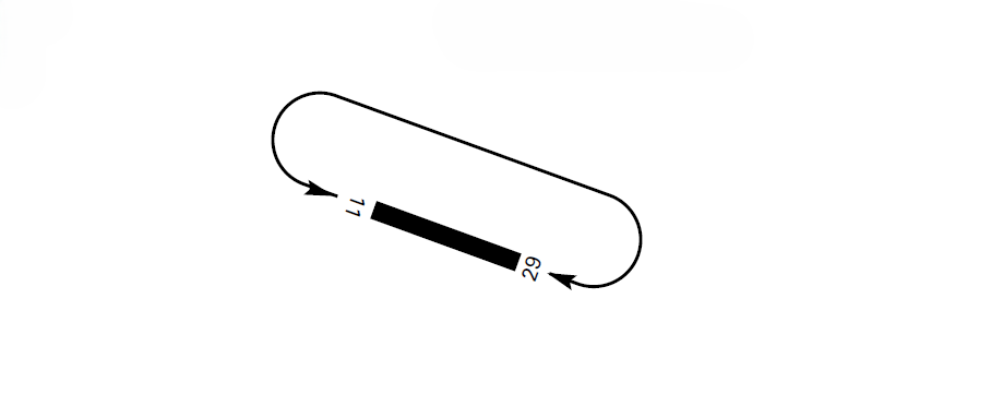
AD TRAFFIC CIRCUIT
ADDITIONAL INFORMATION
Caution due to bird concentration on RWY 11/29 and in the vicinity of the aerodrome.
Notification to aircraft equipped with TCAS, version prior to number 7, operating at Santander/Seve Ballesteros-Santander airport or in the vicinity:
-
For continuous performance verification of the en-route radar located at in Solórzano (Cantabria), a fixed radar transponder has been installed in the airport TWR with the following characteristics:
-
Location: 432521.6519N 0034919.6526W (3.87 DME SNR, 0.28 NM South of ARP).
-
Alpha Mode code: 7777
-
Antenna altitude: 123.70 ft.
-
Aircraft equipped with TCAS, version prior to number 7, during approach or overflying at low altitude close to these coordinates, may receive TCAS traffic advisories corresponding to this fixed transponder. These indications do not identify real traffic and should be ignored.
WIND PHENOMENA
The orographic conditions of Cantabria and the location of Santander/Seve Ballesteros-Santander airport contribute, under certain conditions, to the appearance of wind shear and turbulence phenomena in THR 29 approach. At this location, an S-SW wind creates severe turbulence that can be noticed in an area up to 10 NM, from the ground up to 1800 ft estimated altitude. These phenomena occur when the wind measured at THR 29 varies between 190º and 220º, with intensity equal to or greater than 20 kt, accompanied by frequent gusts above 30 kt.
In these situations, the THR 29 approach is not recommended.
BIRD CONCENTRATION AREAS AND MOVEMENTS OF BIRDS
Between approximately 15 June and 15 September (with greatest likelihood during the months of July and August), after days of rain, with stable environmental conditions, high humidity and temperature, and in the absence of rain and wind; there may be occasional concentrations of gulls (principally of yellow-legged gulls, Larus michahellis), due to the massive presence of flying ants over the runway and over unpaved areas.
BIRD CONCENTRATION AREAS – ATTRACTION POINTS
AREA 1: Laguna de Parayas (inside the aerodrome).
AREA 2: Marismas de Alday.
AREA 3: Agro-food material warehouses at Raos industrial estate.
AREA 4: Ensenada de San Bartolomé.
BIRD MOVEMENTS
MOVEMENT A: Movements of mute swan and mallard (generally parallel to the runway and between AREAS 1, 2 and 4).
MOVEMENT B: Movements of yellow-legged gull (outside threshold 11 and threshold 29).
MOVEMENT C: Movements of rock dove (outside threshold 11).
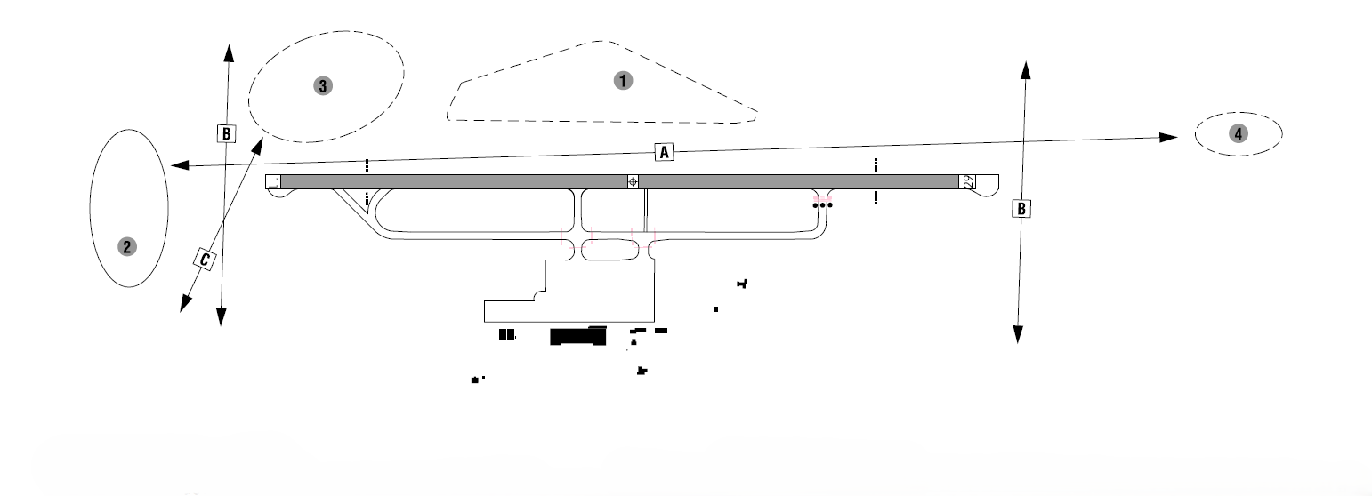
PRESENCE OF SMOKE
Occasional presence of thick smoke at 1.2 NM from THR 29 in the vicinity of coordinates 432447.8N 0034631.5W.
AERONAUTICAL CHARTS RELATED TO AN AERODROMECHARTS RELATED TO THE AERODROME
The list of charts related to the aerodrome can be found on the link below:
VISUAL SEGMENT SURFACE (VSS) PENETRATION
The instrument approach procedures affected can be found below:
IAC 1 RNP Z RWY 11 (LPV ONLY): LPV.
IAC 2 RNP Y RWY 11: LNAV, LNAV/VNAV.
IAC 3 VOR RWY 11: Direct approach.
IAC 4 NDB RWY 11: Direct approach.
IAC 6 RNP Y RWY 29: LNAV, LNAV/VNAV.
IAC 10 VOR RWY 29: Direct approach.