GECE AD 3 HELIPORT DATA
HELIPORT LOCATION INDICATOR and - NAME
GECE - CEUTA
HELIPORT GEOGRAPHICAL AND ADMINISTRATIVE DATA
Heliport reference point |
355334N 0051823W. See AD 3-GECE HELC. |
|
Distance and direction from the city |
0.5 km to the North. |
|
Elevation |
3 m / 9 ft. |
|
Geoid undulation |
42.02 ± 0.05 m. (1) |
|
Reference temperature |
27.6º C. |
|
Low average temperature |
13º C. |
|
Magnetic variation |
2º W (2015). |
|
Annual change |
INFO NO AVBL. |
|
Heliport administration |
Aena. |
|
Address |
Helipuerto de Ceuta, Avda. Compañía del Mar s/n - 51001 Ceuta. |
|
TEL |
+34-956 527 302; +34-667 197 305 |
|
FAX |
+34-956 527 329 |
|
AFTN |
GECE |
|
Approved traffic |
VFR. |
|
Remarks |
(1) For other operational hours, following prior request, consult NOTAM in force. |
OPERATIONAL HOURS
Heliport |
V: MON-FRI 0525-2010, SAT 1415-1550, SUN 1255-2010; |
|
Customs and Immigration |
HR HLP. |
|
Health and Sanitation |
No. |
|
AIS/ARO |
H24. (2) |
|
MET briefing |
HR HLP. |
|
ATS |
No. |
|
Fuelling |
No. |
|
Handling |
HR HLP. |
|
Security |
HR HLP. |
|
De-icing |
No. |
|
Remarks |
(1) For other operational hours, following prior request, consult NOTAM in force. (2) Centralised ARO Office Geographical Area 14.
Centralised AIO Office – International NOTAM Office.
|
HANDLING SERVICES AND FACILITIES
Cargo facilities |
No. |
|
Fuel types |
No. |
|
Oil types |
No. |
|
Refuelling capacity |
No. |
|
De-Icing facilities |
No. |
|
Hangar space |
No. |
|
Repair facilities |
No. |
|
Remarks |
None. |
PASSENGER FACILITIES
Hotels |
In the city. |
|
Restaurant |
No. |
|
Transportation |
Taxi. |
|
Medical facilities |
No. |
|
Bank/Post Office |
No. |
|
Tourist information |
Yes. |
|
Remarks |
None. |
RESCUE AND FIREFIGHTING SERVICES
Fire category |
H-3. (1) |
|
Rescue equipment |
In accordance with the fire category published. |
|
Removal of disabled helicopters |
Yes. (2) |
|
Remarks |
(1) For other fire categories, following prior request, consult NOTAM in force. |
SEASONAL AVAILABILITY -/OBSTACLE CLEARING
Equipment |
No. |
|
Priority |
No. |
Aprons, taxiways and check locations/positions dataMOVEMENT AREA DETAILS
FATO (1) |
Surface: Asphalt. Strength: PCN 51/F/A/W/U. |
|
Apron (2) |
Surface: Asphalt. Strength: PCN 51/F/A/W/U. |
|
TLOF (3) |
Surface: Concrete. Strength: PCN 133/R/A/W/U. |
|
Taxiway |
1 (Access to TLOF Nº1) Width: 5 m. Surface: Concrete. Strength: PCN 133/R/A/W/U. |
|
Taxiways |
2, 3, 4 and 5 (Access to TLOF Nº2, TLOF Nº3, TLOF Nº4, TLOF Nº5) Width: 6.5 m. Surface: Concrete. Strength: PCN 133/R/A/W/U. |
|
Taxiway |
6 (Access to TLOF Nº1A) Width: 9.1 m. Surface: Asphalt. Strength: PCN 51/F/A/W/U. |
|
Check locations |
Altimeter: TLOF (4): ELEV 3 m / 10 ft. VOR: No. INS: No. |
|
Remarks |
|
MARKINGS AND MARKERS
Final approach markings |
Aiming point. |
|
Take-off markings |
Designators and edge. |
|
Taxiway markers |
No. |
|
Air taxiway markers |
No. |
|
Air transit route markers |
No. |
|
Ground taxiway markers |
No. |
|
Ground transit routes markers |
No. |
|
Remarks |
None. |
HELIPORT OBSTACLES
Obstacles in Approach, Take-Off Climb, Conical, Inner Horizontal, Transitional, Inner Transitional and Balked Landing Surfaces established in ICAO Annex 14; and the areas 2A and 3 established in ICAO Annex 15. Those penetrating these surfaces are identified in the CSV file as “Relevante_Relevant = Si/Yes”. |
See Item 10 and Data Set. s section. |
|
Remarks |
See AD 3-GECE AOC. |
METEOROLOGICAL INFORMATION SERVICE PROVIDED
MET office |
No. |
|
HR |
No. |
|
METAR |
AUTO H24 half-hourly. (1) |
|
TAF |
24 HR. |
|
TREND |
No. |
|
Briefing |
Observed lightning and forecasted storm warnings available. |
|
Flight documentation/Language |
No. |
|
Charts |
No. |
|
Supplementary equipment |
No. |
|
ATS unit served |
None. |
|
Additional information |
Sevilla OMAe (LESV): H24
|
|
Remarks |
(1) In addition, meteorological information about wind speed and direction, visibility, RVR, current weather (precipitation, fog, mist, haze and storms), cloud amount, height of cloud base, air temperature, dew point and QNH is broadcasted, in English and Spanish with 5 SEC in pause, on frequency 122.500 MHz. |
HELIPORT DATA
Type of heliport |
Surface-level heliport. |
|
TLOF Nº 1 |
Dimensions: 15 x 15 m. Elevation: 3 m / 9 ft. MAX HEL dimensions: 13 m. Surface: Concrete. Strength: PCN 133/R/A/W/U. Coordinates: 355330.98N 0051825.94W. |
|
TLOF Nº 1A |
Dimensions: 18.5 x 18.5 m. Elevation: 3 m / 9 ft. MAX HEL dimensions: 16.6 m. Surface: Asphalt. Strength: PCN 51/F/A/W/U. Coordinates: 355331.10N 0051825.32W. |
|
TLOF Nº 2 |
Dimensions: 14.5 x 14.5 m. Elevation: 3 m / 9 ft. MAX HEL dimensions: 16.7 m. Surface: Concrete. Strength: PCN 133/R/A/W/U. Coordinates: 355331.59N 0051824.44W. |
|
TLOF Nº 3 |
Dimensions: 14.5 x 14.5 m. Elevation: 3 m / 9 ft. MAX HEL dimensions: 16.7 m. Surface: Concrete. Strength: PCN 133/R/A/W/U. Coordinates: 355332.04N 0051823.30W. |
|
TLOF Nº 4 |
Dimensions: 15 x 15 m. Elevation: 3 m / 9 ft. MAX HEL dimensions: 16.7 m. Surface: Concrete. Strength: PCN 133/R/A/W/U. Coordinates: 355332.43N 0051822.22W. |
|
TLOF Nº 5 |
Dimensions: 15 x 15 m. Elevation: 3 m / 9 ft. MAX HEL dimensions: 16.7 m. Surface: Concrete. Strength: PCN 133/R/A/W/U. Coordinates: 355332.93N 0051820.99W. |
|
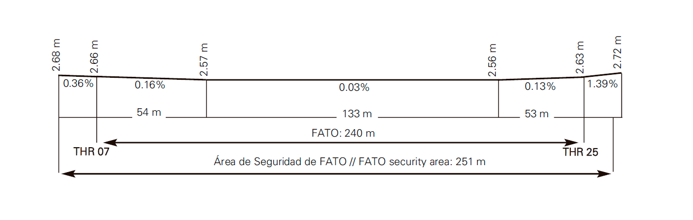
FATO |
Magnetic heading: 065º-245º. (1) Dimensions: 240 x 35 m. Elevation: 3 m / 9 ft. Surface: Asphalt. Strenght: PCN 51/F/A/W/U. Coordinates: THR 07: 355331.95N 0051826.97W; ELEV 3 m / 9 ft. |
|
| Safety area dimensions | 251 x 46 m. | |
| Heliport CWY dimensions | No. | |
| Obstacle-free sector | No. | |
| Remarks | (1) FATO coincident with TLOF from sunrise to sunset. |
FATO Profile
DECLARED DISTANCES
| FATO | TODAH (m) | RTODAH (m) | LDAH (m) |
|---|---|---|---|
| 07 | 240 | 240 | 240 |
| 25 | 240 | 240 | 240 |
| Remarks | None. | ||
APPROACH AND FATO LIGHTING
FATO 07 |
Approach: No. APAPI (MEHT): 5.62º (5.56 m / 18 ft). |
|
FATO 25 |
Approach: No. APAPI (MEHT): 9.87º (9.49 m / 31 ft). |
|
FATO area lighting |
Characteristics: Omnidirectional white. Location: Edge and THR. |
|
Aiming point lighting |
Characteristics: Omnidirectional white. Location: Aiming point. |
|
TLOF lighting system |
Characteristics: Floodlighting poles. Location: Floodlighting poles in terminal building. |
|
Remarks |
Lighting available on 123.325 MHz frequency: |
OTHER LIGHTING, SECONDARY POWER SUPPLY
Heliport BCN |
FLG W EV 2s. |
|
WDI |
1 near THR 07. LGTD. |
|
Apron |
See item 14 TLOF lighting. |
|
Secondary power supply |
Engine generators that provide a maximum switch-over time (light) of 15 seconds to all the lighting systems. |
|
Remarks |
None. |
Air traffic services airspaceATS AIRSPACE
|
Designation |
No. |
Lateral limits |
- | |
Vertical limits |
- | |
Airspace class |
- | |
Unit Language |
- | |
Transition altitude |
- | |
Hours of applicability |
- |
|
Remarks |
None. |
Air traffic services communication facilitiesATS COMMUNICATION FACILITIES
| Service | Call sign | FREQ | HR | Remarks |
|---|---|---|---|---|
| No | No | 123.325 MHz | HR HLP | HLP without ATS service. Only air/air communications: usable between HLP within 15 NM radius of HRP and below 3000 ft. |
| 122.500 MHz | HR HLP | AWOS system. | ||
RADIO NAVIGATION and landing aidsfacilities
| Installation (VAR) | ID | FREQ | HR | Coordinates | ELEV DME | Remarks |
|---|---|---|---|---|---|---|
| NDB (2ºW) | CEU | 300 kHz | H24 | 355333.2N 0051819.6W | - | - |
| DME | CEU | CH 124Y | H24 | 355333.0N 0051819.0W | 0 m / 0 ft | U/S BTN 040º/290º. 000º distance error BTN 0 NM and 1 NM. |
LOCAL heliport REGULATIONS
COMMUNICATION OF DEPARTURES AND ARRIVALS
The departure/arrival of flights from/to Ceuta must be reported to the Centralised ARO by the pilot in command of the aircraft.
TAXIING ROUTES
A TLOF has been defined, coinciding with the FATO, for the operation of helicopters which have wheeled landing gear. Pursuant to the applicable regulations, the FATO may only be used as TLOF by day (sunrise to sunset).
Once the final approach to FATO has been accomplished, if the helicopter has means to carry out ground taxiing, and the operation is taking place between sunrise and sunset, it shall proceed to touch down in the FATO, defined as TLOF.
Otherwise, it shall carry out air taxiing to the TLOF situated at the assigned stand. In both cases, the taxiing shall be performed inside the safety limits of the taxiway and the stand.
Taxiways for access to PRKG TLOF 1, TLOF 1A, TLOF 2, TLOF 3, TLOF 4 and TLOF 5 from FATO are defined: Arrival manoeuvres: After final approach to FATO, carry out taxiing up to the TLOF indicated, in direction perpendicular to FATO. Take the centre of the TLOF as visual reference. Departure manoeuvres: Taxiing from TLOF up to FATO in direction perpendicular to the FATO.
Manoeuvres from FATO to TLOF and vice versa, shall start and finish, respectively, at the points RA 1, RA 1A, RA 2, RA 3, RA 4 and RA 5, with the following coordinates:
- RA 1: 355332.11N 0051826.61W.
- RA 1A: 355332.31N 0051826.04W.
- RA 2: 355332.69N 0051825.11W.
- RA 3: 355333.15N 0051823.98W.
- RA 4: 355333.57N 0051822.92W.
- RA 5: 355334.07N 0051821.69W.
SIMULTANEOUS OPERATIONS BETWEEN FATO AND STANDS
Simultaneous operations are considered to be those in which one aircraft is operating on the FATO (either landing or taking off), and another aircraft has its rotors running on the stand.
After analysing the safety areas required between the FATO and the stands, it is concluded that simultaneous operations are allowed between FATO and stands for the maximum aircraft defined for each stand (EC45 for PRKG TLOF 1 and A139 for PRKG TLOF 2, TLOF 3, TLOF 4 and TLOF 5). For PRKG TLOF 1A, the MAX HEL dimension (D) that allows simultaneous operations is D≤22.5 m (S61).
SIMULTANEOUS OPERATIONS BETWEEN STANDS: AIR TAXIING AND GROUND TAXIING
Simultaneous operations are considered to be those where one aircraft is on the stand with rotors running and another aircraft is in movement from/to the adjacent stand.
Simultaneous operations are allowed between TLOF 1, TLOF 2, TLOF 3, TLOF 4 and TLOF 5 provided that the following conditions are met:
- The aircraft operating on PRKG TLOF 2, TLOF 3, TLOF 4 and TLOF 5 must have a MAX DIM equal to or less than A139 (D=16.65 m).
- The aircraft operating on PRKG TLOF 1 must have a MAX DIM equal to or less than EC45 (D=13.03 m).
Simultaneous operation between PRKG TLOF 1A and PRKG TLOF 1 and TLOF 2 is not allowed.
PARKING OF AIRCRAFT WITH MAX DIM > 16.65 M (A139):
The use of PRKG TLOF 1A, as it is an overlapped and secondary use stand, must be requested to the Heliport Operations Centre (CEOPS) at least 24 hours in advance.
ARRIVING AIRCRAFT WITHOUT PREVIOUSLY ASSIGNED STAND
In exceptional cases, when the arrival of the aircraft has not been communicated sufficiently in advance for it to have been assigned a stand before it is in flight, the helicopter shall access PRKG TLOF 1 by default, unless its DIM is greater than that allowed, in which case it may use PRKG TLOF 2 or TLOF 1A, as appropriate. CEOPS shall notify the SSEI so that they may assist the crew if necessary and ensure they park at the assigned stand.
NOISE ABATEMENT PROCEDURES
No.
FLIGHT PROCEDURES
LOW VISIBILITY PROCEDURES (LVP)
Low Visibility Procedures (LVP) are not available at Ceuta heliport.
ADDITIONAL INFORMATION
In the vicinity of the heliport there are migratory routes crossing the strait that cause significant concentrations of birds, at different heights, which often coincide with the months of February and March in migratory flows from north to south, and in September and October in the flows from south to north, although these periods may be advanced or extended depending on general weather conditions.
Caution due to bird concentration all year long.
Caution in port area. Presence of high masts in ship docking manoeuvres (Dique de Levante and Muelle España) that could affect the obstacle limitation surfaces during the takeoff ascent and landing 07 and 25.
Request information by air frequency.
Charts related to a heliportCHARTS RELATED TO THE HELIPORT
The list of charts related to the heliport can be found on the link below:
VISUAL SEGMENT SURFACE (VSS) PENETRATION
No.