LEZG AD 2 AERODROME DATA
AERODROME LOCATION INDICATOR AND-NAME
LEZG - ZARAGOZA
AERODROME GEOGRAPHICAL AND ADMINISTRATIVE DATA
ARP |
413958N 0010230W. See AD 2-LEZG ADC. |
|
Distance and direction from the city |
10 km NW. |
|
Elevation |
263 m / 862 ft. |
|
Geoid undulation |
49.90 m ± 0.05 m (1). |
|
Reference temperature |
32ºC. |
|
Low average temperature |
7ºC. |
|
Magnetic variation |
0º (2020). |
|
Annual change |
8.0' E. |
|
AD administration |
CIV: Aena. MIL: Ejército del Aire y del Espacio. |
|
Address |
CIV: Aeropuerto de Zaragoza; 50190 Zaragoza. MIL: Base Aérea de Zaragoza; 50071 Zaragoza. |
|
TEL |
CIV: +34-976 712 300 MIL: +34-976 708 503 |
|
FAX |
MIL: +34-976 708 017 |
|
AFTN |
LEZG |
|
|
CIV: ceopsza@aena.es |
|
Approved traffic |
IFR/VFR (2). |
|
Remarks |
Payment of charges in cash will only be accepted in euros (€), up to the maximum permitted by the current law of Spain. (1) For all AD points. (2) IFR/VFR general aviation traffic is dependent upon the apron capacity. These aircraft must request SLOT PPR 3 HR from LEZG CEOPS via TEL: +34-976 712 304 or AFTN: LEZGYFYX. Aircraft type, registration number, operator, departure and destination aerodrome and EOBT, ETA and ETD must be included in the request. Traffic withoutclearance will not be allowed. |
OPERATIONAL HOURS
Airport |
CIV: V: 0445-2100, PS HR PPR (1); I: 0545-2200, PS HR PPR (1). H24 all year long for cargo flights. MIL: H24. (2) |
|
Customs and Immigration |
Customs: CIV: H24. MIL: NO (O/R via PPR with 72h in advance). Immigration: V: 0445-2100, I: 0545-2200. |
|
Health and Sanitation |
CIV: NO. See GEN 1.4. MIL: Subject to availability. |
|
AIS/ARO/OPV |
H24. (3) |
|
MET briefing |
CIV: H24. |
|
ATS |
H24. |
|
Fuelling |
HR AD y O/R. |
|
Handling |
HR AD. |
|
Security |
H24. |
|
De-icing |
H24. |
|
Remarks |
(1) Extension of operational hours for passenger aircraft: see item 20: Local regulations. (2) For foreign state/military aircraft (see item 20: Local Regulations) is mandatory request PPR at least 72 hours in advance to:
(3) Centralised AIO Office - International NOTAM Office
Centralised ARO Office geographical area 3
|
HANDLING SERVICES AND FACILITIES
Cargo facilities |
CIV: No limitations. MIL: Up to 170 Tm. |
|
Fuel types |
CIV: JET A-1, 100LL (1). MIL: F-34. |
|
Oil types |
CIV: No. MIL: 246, 283; C-620, 642; G-353, 354, 355, 359, 366, 372, 382, 392, 395, 396, 403, 412; H-515, 537, 542; O-113, 117, 128, 133, 135, 142, 147, 148, 153, 155, 156, 157, 158, 190, 192, 218, 226, 228, 237, 238, 278,1177, 1236; S-720, 722, 736, 740, 743, 750, 752, 753, 758, 1735, TF-02, 03, 05; TG-09, 15; TH-36; TS-01, 07. |
|
Refuelling capacity |
CIV: No limitations. MIL:
|
|
De-Icing facilities |
CIV: Yes, de-icing service is available at commercial aviation stands, using hot water and glycol units for the removal of ice from aircraft. Service provided by handling agents. MIL: NO. |
|
Hangar space |
No. |
|
Repair facilities |
No. |
|
Remarks |
(1) Exolum Aviation. Company
SLCA Company. MIL: GPU: AC unit (up to 120 KVA) and DC (up to 2500 A). APU: AC unit (up to 1.10 kg/s at 46.3 p.s.i.). It is mandatory to have handling agent for all civilian operations, non-commercial operations included. In arrival operations, passengers and crews must wait for their handling agent. Ramp agents:
SOUTH GROUNDFORCE UNITED AVIATION Ramp agents may attend commercial aviation as well as general aviation. |
PASSENGER FACILITIES
Hotels |
MIL: Yes, subject to availability, exclusively military personnel O/R with 72 hours in advance. |
|
Restaurant |
Yes. |
|
Transportation |
CIV: Buses, taxies and hire cars. MIL: Buses and light vehicles are subject to logistic availability and prior request of PPR. |
|
Medical facilities |
CIV: No. MIL: First aid and ambulance, subject to availability. |
|
Bank/Post Office |
Cash dispenser. Money exchange/No. |
|
Tourist information |
CIV: Yes. MIL: No. |
|
Remarks |
None. |
RESCUE AND FIREFIGHTING SERVICES
Fire category |
CIV: 7. (1) MIL: 8. |
|
Rescue equipment |
CIV: In accordance with the fire category published. MIL: In accordance with the fire category published. |
|
Removal of disabled aircraft |
CIV: Yes. 3 aircraft rescue platforms with load capacity up to 5000 kg, 10000 kg and 30000 kg. For higher capacities, service provided by external company. MIL: Yes, subject to availability. (2) |
|
Remarks |
(1) 8 / 9 upon request, according to procedure (see item 20). (2)
|
RUNWAY SURFACE CONDITION ASSESSMENT AND REPORTING, AND SNOW PLAN
Types of clearing equipment |
CIV: Snowplough truck equipped with melter spreader and blade. Sweeper vehicle equipped with blade. MIL: Aspiration sweeper machines. |
|
Clearance priorities |
CIV: RWY12L/30R; TWY A-5, TA, A-1 and SSEI exit to the runway; access TWY C-1.1 to the civil apron; inner apron taxiway, stands necessary, and the entire apron. MIL: Runways, taxiways and apron. |
|
Use of material for movement area surface treatment |
CIV: Potassium acetate (KAC), sodium formate (NAFO) and urea (UREA). |
|
Specially prepared winter runways |
Not applicable. |
|
Remarks CIV |
Period of application of snow plan: 01-DEC to 31-MAR. Runway surface condition assessment and reporting in accordance with the Global Reporting Format (GRF) methodology described in AD 1.2.2. Aerodrome in service during all seasons of the year. |
APRONS, TAXIWAYS AND CHECK LOCATIONS/POSITIONS DATAMOVEMENT AREA DETAILS
Apron |
Surface: CIV: PRKG 1 to 16: Concrete. PRKG 20 to 23 (General Aviation): Asphalt. PRKG 30 to 34 (Hangar apron) (1): Asphalt. MIL: Concrete. Strength: CIV: PRKG 1 to 8A: PCN 64/R/B/W/T. PRKG 9 and 9A: PCN 107/R/B/W/T. PRKG 12 and 13: PCN 99/R/B/W/T. PRKG 14 to 16: PCN 62/R/B/W/T. PRKG 20 to 23 (General Aviation): PCN 45/F/C/W/T. PRKG 30 to 34 (Hangar apron) (1): PCN: 32/F/B/W/T. MIL: EAST: PCN 90/R/A/W/T. SOUTH: PCN 136/R/A/W/T. WEST: INFO NO AVBL. |
|
Taxiways |
Width: 23 m. EXC A-1: 22.3 m; B-3, C-3: 22.5 m; A-5, TB, B-1, B-2, B-4, B-5: 22.6 m; C-1: 23.6 m; C-1.1: 25 m; TC: INFO NO AVBL. Surface: Asphalt EXC B-1: Concrete. Strength: A-1: PCN 92/F/B/W/T. A-2: PCN 147/F/A/W/T. A-3: PCN 153/F/A/W/T. A-4: PCN 158/F/A/W/T. A-5, TA: PCN 143/F/A/W/T. B-1: PCN 49/R/A/W/T. B-2: PCN 17/F/A/X/T. B-3, C-3: INFO NO AVBL. B-4: PCN 52/F/A/X/T. B-5: PCN 26/F/A/W/T. C-1: PCN 61/F/A/Y/T. C-1.1: PCN 105/F/A/W/T. C-2.2: PCN 112/F/A/W/T. C-4: PCN 56/F/A/X/T. TB: PCN 41/F/A/W/T. Section of 1650 m FM B-1: PCN 49/R/A/W/T. TC: PCN 62/F/A/W/T. |
|
Check locations |
Altimeter: CIV Apron: ELEV 296 m / 971 ft. MIL EAST apron: 251 m / 823 ft. MIL WEST apron: 252 m / 827 ft. MIL SOUTH apron: 272 m / 892 ft. THR: See item 12, runway physical characteristics for each THR ELEV. VOR: No. INS: See AD 2-LEZG PDC. |
|
Remarks |
(1) Hangar apron: Usable from sunrise to sunset by general aviation, 13.56 m MAX wingspan. |
SURFACE MOVEMENT GUIDANCE AND CONTROL SYSTEM AND MARKINGSTAXIING GUIDANCE SYSTEM AND MARKINGS
Taxiing guidance system |
Runway-holding positions,signs, stands. Runway guard lights and stop bars on A-1, A-2, A-3, A-4, A-5 and C-1 (1). |
|
RWY markings |
Designation, threshold, centre line, touchdown zone, side stripe, aiming point and remaining distance signs. Non standar marking in RWY12R/30L only for military use. Marks location: BTN 1138M AND 2512M FM THR12R/1206M and 2580M FM THR30L. |
|
TWY markings |
Centre line and side stripe. Edge markers on TWY TA, A-1, A-2, A-3, A-4, A-5, C-1.1 and C-2.2. |
|
Remarks |
(1) Runway guard lights and stop bars associated to RWY 12L/30R. |
AERODROME OBSTACLES
Obstacles which penetrate Approach, Take-Off Climb, Conical, Inner Horizontal, Transitional, Inner Transitional and Balked Landing Surfaces established in ICAO Annex 14; and the areas 2A and 3 established in ICAO Annex 15. Those penetrating these surfaces are identified in the CSV file as “Relevante_Relevant = Si/Yes”. |
See Item 10 and Data Sets section. |
|
Remarks |
See AD 2-LEZG AOC. |
METEOROLOGICAL INFORMATION PROVIDEDMETEOROLOGICAL SERVICE PROVIDED
MET office |
CIV: Zaragoza EMAe. MIL: OMD of Zaragoza Air Base. |
|
HR |
CIV: H24. MIL: V: 0400-1600. I: 0500-1700. |
|
METAR |
Half-hourly. |
|
TAF |
24 HR. |
|
TREND |
Yes. |
|
Landing forecast |
No. |
|
|
Briefing |
In person and by telephone. |
|
Flight documentation/Language |
Charts and plain language / Spanish. |
|
Charts |
Forecasted significant weather and wind and temperature at altitude maps. |
|
Supplementary equipment |
Aeronautical meteorological self-service, cloud image, lightning and radar information display. |
|
ATS unit served |
AIS, TWR, Zaragoza TACC/APP. |
|
Additional information |
Valencia OMAe (LEVA): H24
Zaragoza EMAe: H24
|
Remarks |
Aerodrome climatological summary available. Aerodrome warnings available. |
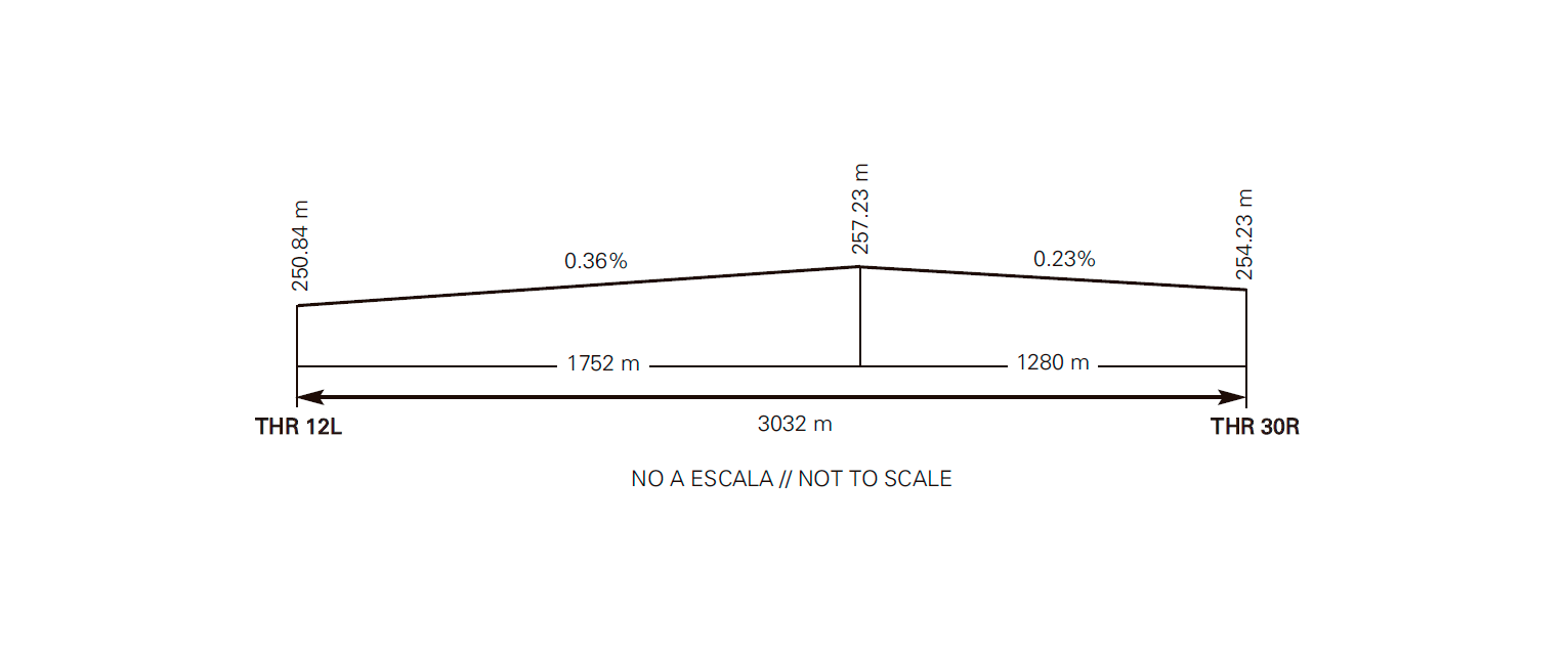
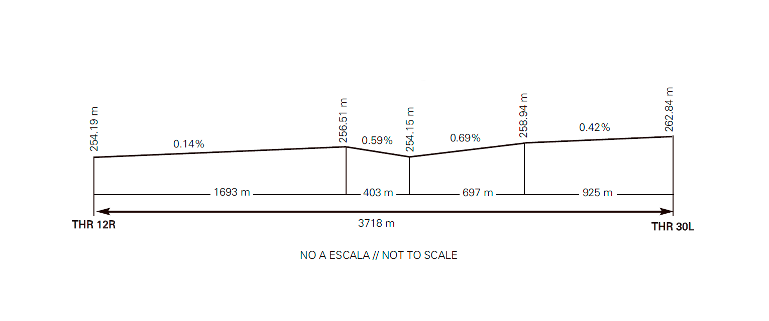
RUNWAY PHYSICAL CHARACTERISTICS
RWY |
Direction |
DIM (m) |
THR PSN |
TDZ ELEV |
SWY (m) |
CWY (m) |
Strip (m) |
OFZ |
RESA (m) |
RWY/SWY SFC |
|---|---|---|---|---|---|---|---|---|---|---|
12L |
120.03° GEO / 120° MAG |
3032 x 45 |
414008.62N 0010223.40W |
THR: 251 m / 823 ft. TDZ: No |
300 x 45 (1) |
690 x 150 |
3605 x 300 |
No |
240 x 150 |
RWY: ASPH |
30R |
300.05° GEO / 300° MAG |
3032 x 45 |
413919.42N 0010029.94W |
THR: 254.0 m / 834 ft. TDZ: 255.5 m / 838 ft |
185 x 45 (1) |
No |
3605 x 300 |
No |
240 x 150 |
RWY: ASPH |
12R |
120.00° GEO / 120° MAG |
3718 x 45 |
414048.74N 0010456.54W |
THR: 254 m / 834 ft. TDZ: No |
300 x 45 (1) |
850 x 150 |
4438 x 300 |
No |
240 x 150 |
RWY: ASPH (4) |
30L |
300.03° GEO / 300° MAG |
3718 x 45 |
413948.46N 0010237.37W |
THR: 263 m / 862 ft. TDZ: No |
300 x 45 (1) |
850 x 150 |
4438 x 300 |
No |
240 x 150 |
RWY: ASPH (4) |
Remarks: |
||||||||||
PROFILE
DECLARED DISTANCES
RWY |
TORA (m) |
TODA (m) |
ASDA (m) |
LDA (m) |
|---|---|---|---|---|
12L |
3032 |
3722 |
3332 |
3032 |
30R |
3032 |
3032 |
3217 |
3032 |
12R |
3718 |
4568 |
4018 |
3718 |
30L |
3718 |
4568 |
4018 |
3718 |
12L INT A2 |
2248 |
2938 |
2548 |
- |
12L INT A3 |
1498 |
2188 |
1798 |
- |
30R INT A3 |
1534 |
1534 |
1719 |
- |
30R INT A4 |
2234 |
2234 |
2419 |
- |
12R INT B3 |
1903 |
2753 |
2203 |
- |
12R INT C4/B4 |
2508 |
3358 |
2808 |
- |
30L INT B2 |
2544 |
3394 |
2844 |
- |
30L INT C3/B3 |
1815 |
2665 |
2115 |
- |
Remarks: None |
||||
APPROACH AND RUNWAY LIGHTING
Runway |
12L |
|
Approach |
Simple, 427 m. Threshold identification lights (1). |
|
PAPI (MEHT) |
2.5° (22.02 m / 72 ft). |
|
Threshold |
Green. |
|
Touchdown zone |
No. |
|
Runway centre line |
3032 m: 2132 m white + 600 m white and red + 300 m red. LIH (1). Distance between lights: 15 m. |
|
Runway edge |
3032 m: 2432 m white + 600 m yellow. LIH (1). Distance between lights: 60 m. |
|
Runway end |
Red. |
|
Stopway |
Red. |
|
Remarks |
(1) Adjustable light intensity. |
Runway |
30R |
|
Approach |
Precision CAT II/III, 600 m. LIH (1). Threshold identification lights. |
|
PAPI (MEHT) |
3° (20.10 m / 66 ft). |
|
Threshold |
Green. |
|
Touchdown zone |
900 m white. |
|
Runway centre line |
3032 m: 2132 m white + 600 m white and red + 300 m red. LIH (1). Distance between lights: 15 m. |
|
Runway edge |
3032 m: 2432 m white + 600 m yellow. LIH (1). |
|
Runway end |
Red. |
|
Stopway |
Red. |
|
Remarks |
(1) Adjustable light intensity. |
Runway |
12R |
|
Approach |
Precision CAT I, 581 m. LIH (1). Threshold identification lights. Runway lead-in lighting system. |
|
PAPI (MEHT) |
3° (19.27 m / 63 ft). |
|
Threshold |
Green. |
|
Touchdown zone |
No. |
|
Runway centre line |
No. |
|
Runway edge |
3718 m white. LIH (1). Distance between lights: 60 m. |
|
Runway end |
Red. |
|
Stopway |
No. |
|
Remarks |
(1) Adjustable light intensity. |
Pista |
30L |
|
Approach |
No. |
|
PAPI (MEHT) |
3° (19.31 m / 63 ft). |
|
Threshold |
Green with wing bars. |
|
Touchdown zone |
No. |
|
Runway centre line |
No. |
|
Runway edge |
3718 m white. LIH (1). Distance between lights: 60 m. |
|
Runway end |
Red. |
|
Stopway |
No. |
|
Remarks |
(1) Adjustable light intensity. |
OTHER LIGHTING, SECONDARY POWER SUPPLY
WDI |
1 near THR 30L, LGTD. 1 near THR 12L, 1 near THR 12R, 1 near TWY B-2: No LGTD. |
|
TWY lighting |
Edge EXC TA, A-1, A-2, A-3, A-4, A-5, C-1.1, C-2.2 and civil apron inner TWY. Centre line on TA, A-1, A-2, A-3, A-4, A-5, C-1.1, C-2.2 and civil apron inner TWY. |
|
Apron lighting |
CIV: Floodlighting poles LIH. MIL EAST: 9 floodlighting poles. MIL WEST: 7 floodlighting poles. MIL SOUTH: 5 floodlighting poles. |
|
Secondary power supply |
Runway 12L/30R: Uninterruptible power supply which provides a switch-over time (light) as provided for CAT II/III in Annex 14. Rest of lighting systems: Generators which provide a MAX switch-over time (light) of 15 seconds. |
|
Remarks |
None. |
HELICOPTER LANDING AREA
Position |
|
|
Elevation |
|
|
Dimensions, surface, maximum weight, marking |
|
|
Direction |
Direction of RWY 12L/30R, see item 12. |
|
Declared distances |
|
|
Lighting |
Visual approach slope indicator system: See PAPI of RWY 12L/30R in item 14. Winching area: No. |
|
Remarks |
None. |
AIR TRAFFIC SERVICES AIRSPACEATS AIRSPACE
Designation |
CTR ZARAGOZA. |
|
Lateral limits |
Circle radius 7 NM centred on ARP and a rectangular surface limited by the lines joining: |
|
Vertical limits |
SFC - 1000 ft AGL. |
|
Airspace class |
D. |
|
Unit Lenguage |
Zaragoza APP. |
|
Transition altitude |
1850 m/6000 ft. |
|
Hours of applicability |
- |
|
Remarks |
None. |
Designation |
ATZ ZARAGOZA. |
|
Lateral limits |
Circle radius 8 km centred on ARP (1). |
|
Vertical limits |
SFC - 3000 ft HGT (2). |
|
Airspace class |
D. |
|
Unit Lenguage |
Zaragoza TWR. |
|
Transition altitude |
- |
|
Hours of applicability |
- |
|
Remarks |
(1) Or the ground visibility, whichever is lower. (2) Or up to the cloud ceiling, whichever is lower. |
AIR TRAFFIC SERVICES COMMUNICATION FACILITIESATS COMMUNICATION FACILITIES
Service |
Call sign |
FREQ |
HR |
Remarks |
|---|---|---|---|---|
APP |
Zaragoza APP |
119.305 C |
H24 |
APP/H |
127.055 C |
H24 |
APP/I |
||
125.005 C |
H24 |
APP/I |
||
296.750 MHz |
H24 |
APP/MIL |
||
313.500 MHz |
H24 |
APP/MIL |
||
363.675 MHz |
H24 |
APP/MIL |
||
121.500 MHz |
H24 |
EMERG |
||
243.000 MHz |
H24 |
EMERG |
||
TWR |
Zaragoza TWR |
122.105 C |
H24 |
CIV |
121.500 MHz |
H24 |
EMERG |
||
243.000 MHz |
H24 |
EMERG |
||
118.105 C |
H24 |
GMC |
||
171.000 MHz |
H24 |
GMC Frequency for vehicles taxiing in manoeuvring area and ground coordination for emergencies. |
||
139.300 MHz |
H24 |
MIL |
||
257.800 MHz |
H24 |
MIL |
||
292.200 MHz |
H24 |
MIL |
||
388.200 MHz |
H24 |
MIL |
||
396.900 MHz |
H24 |
MIL |
||
GCA |
Zaragoza GCA |
121.500 MHz |
(1) |
EMERG (1) MON-FRI EXC HOL: V: 0600-1230; I: 0700-1330. |
243.000 MHz |
(1) |
EMERG |
||
130.025 MHz |
(1) |
|||
123.300 MHz |
(1) |
|||
235.125 MHz |
(1) |
|||
281.375 MHz |
(1) |
|||
374.525 MHz |
(1) |
|||
375.575 MHz |
(1) |
|||
387.225 MHz |
(1) |
RADIO NAVIGATION AND LANDING AIDSRADIO NAVIGATION & LANDING FACILITIES
Facility (VAR) |
ID |
FREQ |
HR |
Coordinates |
ELEV |
Remarks |
|---|---|---|---|---|---|---|
VOR (0º) |
ZAR |
113.000 MHz |
H24 |
413928.4N 0010151.1W |
- |
COV: 119°/309° 8500 ft 40 NM, 309°/119° 5500 ft 40 NM. |
DME |
ZAR |
CH 77X |
H24 |
413928.4N 0010151.1W |
270 m |
- |
TACAN (0º) |
ZZA |
CH 64X |
H24 |
414037.6N 0010330.6W |
240 m |
300° MAG 1800 m FM THR 12L, R-123 10000 m NW FM THR 12R COV 50 NM. |
TACAN (0º) |
TZZ |
CH 82X |
H24 |
414008.99N 0010251.28W |
270 m |
- |
NDB (0º) |
ZRZ |
389.000 kHz |
H24 |
414349.9N 0011136.0W |
- |
COV 50 NM. |
LOC 30R (0º) ILS CAT II/III |
IZZA |
109.500 MHz |
H24 |
414017.0N 0010242.8W |
- |
300° MAG / 518 m FM THR 12L. |
GP 30R |
- |
332.600 MHz |
H24 |
413920.9N 0010043.8W |
- |
3°; RDH 16.6 m; at 300 m FM THR 30R & 120 m FM RCL to the left on APCH direction. |
ILS/DME 30R |
IZZA |
CH 32X |
H24 |
413920.9N 0010043.8W |
255 m |
REF DME THR 30R. |
LOCAL AERODROME REGULATIONSLOCAL REGULATIONS
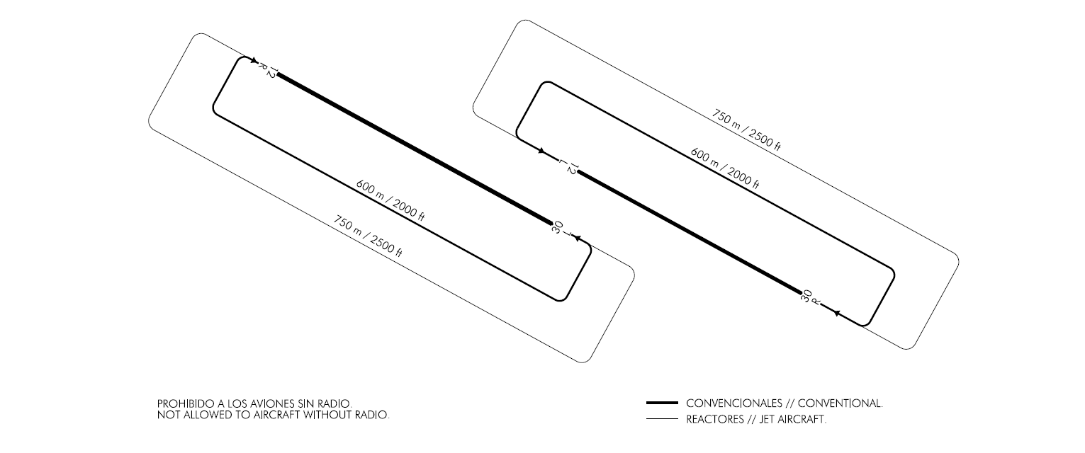
Aerodrome closed to aircraft without radiocommunication equipment.
Caution must be exercised due to military flights.
Simultaneous use of parallel runways VFR/IFR only in VMC.
AIP TAXI PROCEDURE
Code letter E and F aircraft will exit the civil apron via C-2.2 in order to minimise the impact of jet blast in stands.
Restrictions to operations
First 1245 ft of RWY 30L and last 1245 ft of RWY 12R and first 120 ft of RWY 12R and last 120 ft of RWY 30L not usable by light aircraft with tail skid.
No civilian aircraft (IFR/VFR), except those expressly authorized, will be cleared to practice approaches or touch-and-goes. Only the final touchdown will be cleared and only if a flight plan with destination LEZG has been approved.
Foreign state aircraft
When transporting hazardous goods, the PPR application must be made at least three working days in advance.
Ground handling
At Zaragoza Airport, the maximum fees that South Airport Services can charge for the services provided to their clients have been defined. These services include transporting passengers and/or crew from the aircraft to the terminal building and vice versa.
ILS Category II and III Operations
RWY 30R, subject to service availability of the appropriate approach and landing aids, is suitable for carrying out CAT II and III operations by those air operators whose operational minima has been approved by the aeronautical civil authority.
Helicopter operation
Hours of operation in which helicopters can operate are from sunrise to sunset, daytime.
As there is no defined specific area for helicopter operation, they will be treated as fixed-wing aircraft and ATC shall clear them to take off from and land on the runway.
Taxing
-
RWY 12L in use:
-
Departures: Helicopters shall execute air or ground taxiing, as appropriate, via C-2.2 and TA to holding position located at A-1.
-
Arrivals: Helicopters shall complete the final approach to the runway and they shall vacate it via TA. They shall taxi to TWY C-2.2, unless otherwise advised by ATC. They shall execute air or ground taxiing, as appropriate, to the assigned stand.
-
-
RWY 30R in use:
-
Departures: Helicopters shall execute air or ground taxiing, as appropriate, via C-2.2 to holding position located at A-5.
-
Arrivals: Helicopters shall complete the final approach to the runway and they shall vacate it via TA. They shall taxi to TWY C-2.2. They shall execute air or ground taxiing, as appropriate, to the assigned stand.
-
Once on the apron, both air and ground taxiing shall be carried out via the access taxiway to the stand, following its centre line marking on arrival, where they shall obey the directions of the “FOLLOW ME ”vehicle for guidance to the stand.
Simultaneous helicopter taxiing operations are not permitted in the airport.
Taxing Procedures
It’s mandatory for Code letter E and F four-engined aircraft taxiing with outer engines at idle power on the whole movement area.
Taxing procedures for b748 and an124 aircraft
- Arrivals
-
THR 30R: Vacate runway via A-1, taxi via the parallel taxiway TA to C-1.1 and access the apron to the stand.
-
THR 12L: Vacate runway via A-5, cross TA to C-2.2 and access the apron to the stand.
-
THR 12R: Vacate runway via C-1, taxi via TA to C-1.1 and access the apron to the stand.
- THR 30L: This is not allowed for the landing manoeuvre, because TWY B-5 is not appropriate for the size of the B-748 and AN124.
- Departures
-
THR 30R: Departure from apron via C-2.2, cross TA to A-5 and continue to threshold 30R.
-
THR 12L: Departure from apron via C-2.2 to TA, turn right along TA to A-1 and enter runway.
-
THR 30L: departure from apron via TWY C-2.2 to TWY TA, turn left along TWY TA to TWY A-1/C-1 and continue threshold RWY 30L.
- THR 12R: This is not allowed for take-off manoeuvres.
Entry and exit procedure into stands
It´s mandatory access to PRKG 12 and 13 and the access and exit from the PRKG 6, 6A, 7, 7A, 8, 8A, 9 and 9A with two engines running and using minimum thrust to avoid Jet Blast.
Operational safety reports
Pilots/operator shall report any accidents, incidents, occurrences or events which may have a potential operational impact and in which they have been involved or witnessed, to the airport as soon as possible.
The aim of these reports is the compilation of the information in order to improve operational safety, independently of the compulsory report of the occurrence to the appropriate aeronautical authority.
Data may be sent in any format, including at least the following information:
-
Date and time.
-
Site.
-
Parties involved (data used to identify vehicles, aircraft...involved).
-
Companies involved.
-
Description of the facts.
-
Any other data considered relevant (e.g. lighting conditions, weather, phase of the operation such as takeoff / landing / stopover, pavement conditions).
Contact e-mail address of the airport, for the reception of operational safety reports, is the following:
Seguridad_Operacional_ZAZ@aena.es
In addition to notifying the airport by means of the indicated system, it is necessary to send at least basic data of the accident, incident, occurrence or event to the air traffic control service provider (ATC).
Extension of operational hours for passenger aircraft
Commercial aircraft requiring the operational hours of the airport to be extended for passengers should request SLOT PPR 12 HR from LEZG CEOPS by
- TEL (+34-976 712 304),
- E-MAIL (ceopszaz@aena.es)
- or AFTN (LEZGYFYX), and await confirmation or denial of authorisation by the same channel.
The request must include: Type of aircraft, registration, operator, origin and destination aerodromes, EOBT, ETA and ETD.
Airport emergency plan
See AD 1.1 Emergency management
Application procedure for on-demand rescue and firefighting protection level
Operators wishing to operate at Zaragoza Airport with an ICAO-SSEI Category 7 aircraft or higher must apply by e-mail to the following addresses:
mailtoceopszaz@aena.es">ceopszaz@aena.es and zaz.ope.oficina@aena.es; as far in advance of the scheduled arrival date as possible, indicating the aircraft model, date and scheduled time of arrival.
NOISE ABATEMENT PROCEDURES
GROUND ENGINE TEST
Ground engine tests shall be carried out:
-
At the stand itself, on the civilian apron, if conducted at idling power; or
-
At the holding bay located in A-5 at higher declared powers.
Before conducting engine run tests, contact shall be made with the Airport Operations Coordination Centre (CEOPS).
FLIGHT PROCEDURES
Possible delays in arrivals after the landing of heavy turbulent wake aircraft because of the inspection of the runway.
LOW VISIBILITY PROCEDURES (LVP)
GENERAL
RWY 30R is equipped with ILS and authorized for CAT II/III operations and low visibility take-offs (LVTO). RWY 12L is authorized for low visibility take-offs (LVTO).
- Low visibility procedures (LVP) shall be applied when any of the following conditions is met:
-
When any transmissometer indicates RVR lower than 600 m, or visibility lower than 800 m in the case of failure of the transmissometers; or
- When the meteorological report indicates a cloud base height equal to or lower than 250 ft (75 m).
- ATC shall inform pilots by radiotelephone that low visibility procedures are in force. Any incident notified or detected which might affect the LVP shall be communicated immediately to the aircraft so that they can take appropriate measures.
- Because TWR does not have visibility of the civil apron, from the moment at which the application of the Low Visibility Procedures starts, a "follow-me" vehicle shall proceed to guide aircraft pilot request, both on the civil and military aprons.
-
Arrivals: from RWY 30R exit via A-1, A-2, A-3 and A-4 intersections with TA to civil/military apron.
- Departures: from the civil/military apron up to the threshold of the runway in use.
- Normally, while the Low Visibility Procedures (LVP) are in force, only one aircraft/formation will be authorized to taxi at a time in the manoeuvring area.
A single aircraft/formation may taxi in each of the following areas independently:
-
The areas bounded by the East Military Apron, the Civil Apron, RWY 12L/30R, taxiways to the north of said runway and Taxiway C1
-
The areas bounded by the South Military Apron, the Civil Apron, RWY 12R/30L, taxiways to the south of the apron and Taxiway C1.
Taxiway C1 is a common taxiway, therefore when an aircraft is on this taxiway, it shall be considered as movement in both areas, avoiding overlap with other aircraft.
E.- The LVP shall be cancelled when the following conditions are met:
-
When all the transmissometers indicate RVR above 1000 m, or the same value of visibility if the transmissometers are out of service.
-
When the meteorological report indicates a cloud base height equal to or above than 300 ft (90 m).
SURFACE MOVEMENTS
Pilots shall proceed to verify the situation of their aircraft at all times, especially at intersections, ensuring that their taxiing takes place under conditions of complete safety.
The stop bars will be used to manage the surface movements.
In the event that an exiting aircraft has to return to the apron, the pilot shall inform ATC and await new taxiing instructions.
Arrivals
These shall proceed as follows:
-
CIVIL APRON
Vacate RWY30R via A-1, A-2, A-3, A-4 up to TA. Taxi via TA, entering the civil apron via C-1.1/C-2.2, except for other ATC instructions. -
EAST MILITARY APRON
Vacate RWY 30R via A-1, A-2 up to TA. Taxi via TA, entering the east military apron, except for other ATC instructions. -
SOUTH MILITARY APRON
Vacate RWY 30R via C-1 up to B-1. Obtain ATC clearance for crossing RWY 12R/30L. Taxi via TB, entering the south military apron, except for other ATC instructions. -
WEST MILITARY APRON
Vacate RWY 30R via C-1 up to B-1. Obtain ATC clearance for crossing RWY 12R/30L. Taxia via TB, B-3, C-3, TC entering west military apron, except for other ATC instructions.
Departures
These shall proceed according to the runway to be used:
-
RWY 12L:
-
CIVIL APRON
Taxi via C-1.1/C-2.2, TA, to A-1, except for other ATC instructions. -
EAST MILITARY APRON
Taxi via TA, to A-1 except for other ATC instructions. -
SOUTH MILITARY APRON
Taxi via TB, to B-1, C-1. Obtain ATC clearance for crossing RWY 12R/30L except for other ATC instructions. -
WEST MILITARY APRON
Taxi via TC, C-3/C-4, B-3/B-4, to TB, B-1, C-1. Obtain ATC clearance for crossing RWY 12R/30L except for other ATC instructions.
-
-
RWY 30R:
-
CIVIL APRON
Taxi via C-2.2 and A-5 except for other ATC instructions. -
EAST MILITARY APRON
Taxi via TA, to A-5 except for other ATC instructions. -
SOUTH MILITARY APRON
Taxi via TB, to B-1, C-1. Obtain ATC clearance for crossing RWY 12R/30L, TA to A-5 except for other ATC instructions. -
WEST MILITARY APRON
Taxi via TC, C-3/C-4, B-3/B-4, to TB, B-1, C-1. Obtain ATC clearance for crossing RWY 12R/30L, TA to A-5 except for other ATC instructions.
-
COMMUNICATIONS FAILURE AND ANOMALOUS SITUATIONS IN THE MANOEUVRING AREA
COMMUNICATIONS FAILURE
In the event that an aircraft operating in the manoeuvring area should experience a communications failure, it shall proceed as follows:
-
Departing aircraft: the aircraft shall continue by the assigned route and halt at the limit of the ATC clearance, taking extreme care, where it shall hold and await the arrival of an assistance vehicle.
-
Arriving aircraft: if the aircraft has just landed, it shall hold on vacating the sensitive area and await the arrival of an assistance vehicle.
If the aircraft already has ATC taxiing clearance, it shall continue by the assigned route and halt at the limit of the ATC clearance, taking extreme care, where it shall hold and await the arrival of an assistance vehicle.
ANOMALOUS SITUATIONS IN THE MANOEUVRING AREA
- Uncertainty about position in the manoeuvring area.
-
Other than as provided for in the following paragraph, if a pilot is in doubt about the position of the aircraft in relation to the manoeuvring area, they must immediately halt the aircraft and report this circumstance to ATC (including the last known position).
-
In situations in which a pilot is in doubt about the position of the aircraft in relation to the manoeuvring area, but recognises that the aircraft is on a runway, the pilot shall immediately report this to ATC (including the last known position), and vacate the runway as soon as possible, if they can find an appropriate taxiway nearby, unless ATC should indicate otherwise, and then, halt the aircraft.
- In the event that ATC realises that an aircraft or vehicle has lost its position in the manoeuvring area, or is not sure of its position, the appropriate measures shall be taken immediately to safeguard the operations and help the aircraft or vehicle in question to determine its position.
- Loss of visual contact between mobile elements. -
- In the event that one aircraft loses visual contact with another, or with a vehicle with which it is maintaining its own separation, ATC shall be informed immediately, and the aircraft halted. ATC shall take the measures that it shall deem fit.
- Breakdown of aircraft.
-
It shall report the situation to ATC and await the arrival of assistance. Should it find itself on a runway, if possible and unless ATC should indicate otherwise, this shall be vacated.
AD TRAFFIC CIRCUIT
ADDITIONAL INFORMATION
ARRESTING SYSTEMS
Nomenclature |
LEZG-01-C-B |
|
Type |
Retractable bidirectional cable barrier. |
|
Location on runway |
RWY 12L THR + 2577 m/8455 ft. RWY 30R THR + 455 m/1493 ft. |
|
Readiness status |
Permanently available, at pilot request. |
Nomenclature |
LEZG-02-C-B |
|
Type |
Bidirectional cable barrier. |
|
Location on runway |
RWY 12R THR + 3345 m/10974 ft. RWY 30L THR + 380 m/1247 ft. |
|
Readiness status |
Permanently available. |
Nomenclature |
LEZG-03-R/C-U |
|
Type |
Unidirectional net/cable barrier. |
|
Location on runway |
RWY 30L THR + 3758 m/12329 ft. |
|
Readiness status |
Cable mode available. Net mode prior publication of NOTAM. |
|
Nomenclature |
LEZG-04-C-B |
|
Type |
Retractable bidirectional cable barrier. |
|
Location on runway |
RWY 12R THR + 515 m/1690 ft. RWY 30L THR + 3203 m/10509 ft. |
|
Readiness status |
Permanently available, at pilot request. |
RADAR INSTRUMENT APPROACH MINIMA (EXCLUSIVE MILITARY USE).
RWY |
GP/TCH/RPI |
CAT |
DA/MDA-VIS |
HAT/HAA |
CEIL-VIS |
|
|---|---|---|---|---|---|---|
PAR |
30R |
3° / 52 / 983 |
ALL |
1034 - 800 m |
200 |
(200 - 800 m) |
PAR |
12L |
3° / 60 / 1152 |
ALL |
1023 - 800 m |
200 |
(200 - 800 m) |
SRE |
30R |
A - B |
1490 - 800* m |
647 |
(700 - 800* m) |
|
SRE |
30R |
C |
1490 - 2000* m |
647 |
(700 - 2000* m) |
|
SRE |
30R |
D - HPMA |
1490 - 2400* m |
647 |
(700 - 2400* m) |
|
SRE |
30R |
E |
1490 - 2800* m |
647 |
(700 - 2800* m) |
|
SRE |
12L |
A - B |
1250 - 1200** m |
426 |
(400 - 1200** m) |
|
SRE |
12L |
C - D - HPMA |
1250 - 1600** m |
426 |
(400 - 1600** m) |
|
SRE |
12L |
E |
1250 - 2000* m |
426 |
(400 - 2000* m) |
|
SRE |
30L |
A - B |
1550 - 1600 m |
684 |
(700 - 1600 m) |
|
SRE |
30L |
C |
1550 - 3200 m |
684 |
(700 - 3200 m) |
|
SRE |
30L |
D - HPMA |
1550 - 3600 m |
684 |
(700 - 3600 m) |
|
SRE |
30L |
E |
1550 - 4000 m |
684 |
(700 - 4000 m) |
|
SRE |
12R |
A - B |
1340 - 800* m |
501 |
(500 - 800* m) |
|
SRE |
12R |
C - D - HPMA |
1340 - 1600* m |
501 |
(500 - 1600* m) |
|
SRE |
12R |
E |
1340 - 2000* m |
501 |
(500 - 2000* m) |
|
CIR |
A |
1550 - 1600 m |
687 |
(700 - 1600 m) |
||
CIR |
B |
1610 - 2000 m |
747 |
(800 - 2000 m) |
||
CIR |
HPMA |
2000 - 3200 m |
1137 |
(1200 - 3200 m) |
||
CIR |
C - D |
2600 - 4800 m |
1737 |
(1800 - 4800 m) |
||
CIR |
E |
2700 - 4800 m |
1837 |
(1900 - 4800 m) |
* Increase VIS 800 m when ALS U/S.
** Increase VIS 400 m when SALS U/S.
Remarks:
Hours of operation: MON-FRI EXC HOL: V: 0600-1230; I: 0700-1330.
Any modification in hours of operation shall be established by
NOTAM.
BIRD CONCENTRATION
Wood pidgeons and rock doves.
Note: Probability of birds of prey (Vultures, Buzzards, Kites, Eagles, Etc.).
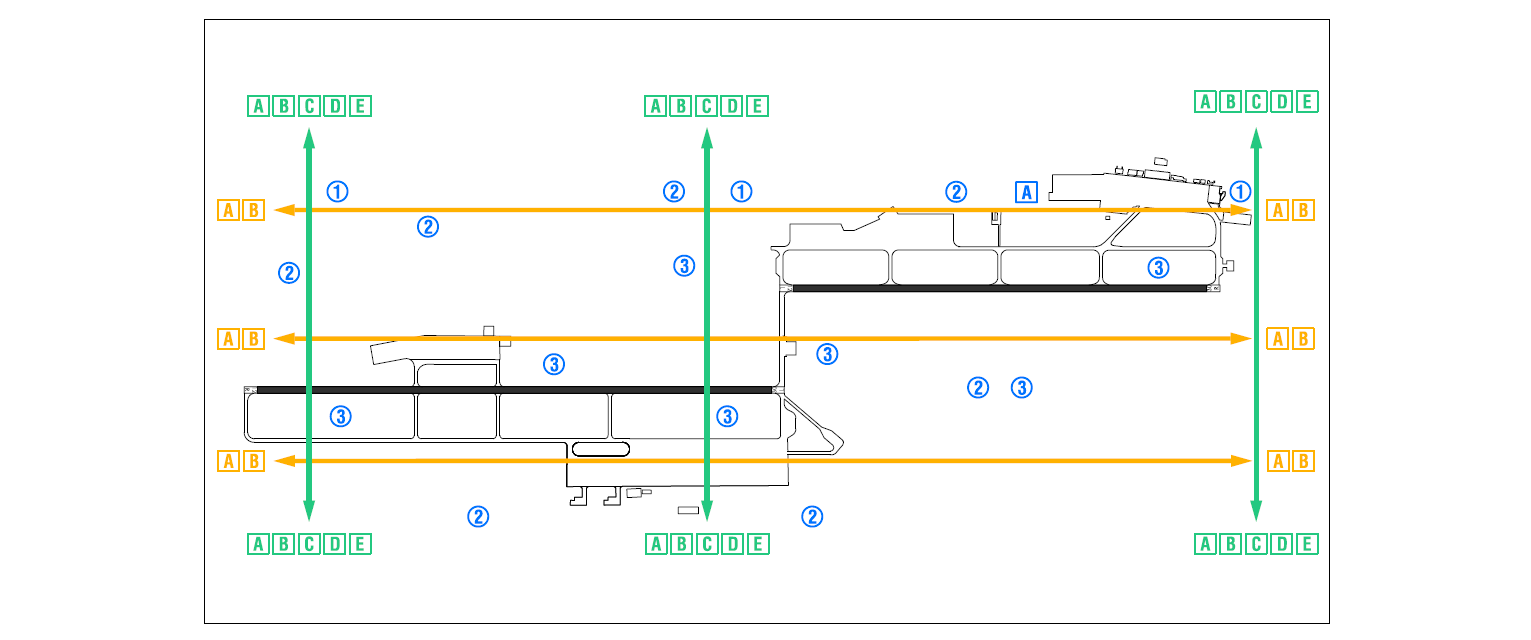
Bird concentration areas:
Zone 1 |
Concentration of starlings. |
|
Zone 2 |
Concentration of wood and rock pigeons. |
|
Zone 3 |
Concentration of birds of prey. |
Bird movement zones:
Movement A |
Movement of vultures and other birds of prey (Summer). |
|
Movement B |
Pigeon movement (All Year). |
|
Movement C |
Movement of starlings (Autumn / Winter). |
|
Movement D |
Movement of cranes (Autumn / Winter). |
|
Movement E |
Movement of White Storks (Summer). |
AERONAUTICAL CHARTS RELATED TO AN AERODROMECHARTS RELATED TO THE AERODROME
The list of charts related to the aerodrome can be found on the link below:
VISUAL SEGMENT SURFACE (VSS) PENETRATION
Not applicable.