LEBT AD 3 HELIPORT DATA
HELIPORT LOCATION INDICATOR and-NAME
LEBT - VALENCIA/Bétera
HELIPORT GEOGRAPHICAL AND ADMINISTRATIVE DATA
Heliport reference point |
393728N 0002820W. See AD 3-LEBT HELC. |
|
Distance and direction from the city |
4 km N. |
|
Elevation |
127 m / 416 ft. |
|
Geoid undulation |
50.58 m ± 0.05 m. (1). |
|
Reference temperature |
30°C. |
|
Low average temperature |
9°C. |
|
Magnetic variation |
1°E (2020). |
|
Annual change |
7.5’E. |
|
HLP administration |
Ejército de Tierra. |
|
Address |
Base de Bétera (BHELEME II). 46117 - Bétera (Valencia). |
|
TEL |
+34-961 606 230/201 |
|
|
FAX |
+34-961 699 277 |
AFTN |
LEBT |
|
No. |
||
Approved traffic: |
IFR/VFR. Exclusive military use. |
|
Remarks: |
(1) For all HLP points. |
OPERATIONAL HOURS
Heliport |
MON-THU: V: 0545-1300; I: 0645-1400. |
|
Customs and Immigration |
No. |
|
Health and Sanitation |
No. |
|
AIS/ARO/OPV |
HR HLP. |
|
MET briefing |
HR HLP. |
|
ATS |
HR HLP. |
|
Fuelling |
HR HLP. |
|
Handling |
HR HLP. |
|
Security |
H24. |
|
De-icing |
No. |
|
Remarks |
None. |
HANDLING SERVICES AND FACILITIES
Cargo facilities |
Claws, ladders and crane. |
|
Fuel types |
JP-8. |
|
Oil types |
No. |
|
Refuelling capacity |
INFO NO AVBL. |
|
De-icing facilities |
No. |
|
Hangar space |
No. |
|
Repair facilities |
No. |
|
Remarks |
None. |
PASSENGER FACILITIES
Hotels |
Yes. |
|
Restaurant |
Yes. |
|
Transportation |
Yes. |
|
Medical facilities |
First aid and ambulance. |
|
Bank/Post Office |
No. |
|
Tourist information |
No. |
|
Remarks |
None. |
RESCUE AND FIREFIGHTINGSERVICES
Fire category |
H3. |
|
Rescue equipment |
In accordance with the fire category published. |
|
Removal of disabled helicopters |
Tractor with dragging bars. |
|
Remarks |
None. |
SEASONAL AVAILABILITY -/OBSTACLE CLEARING
Equipment |
Crane on truck vehicle. |
|
Priority |
RWY and movement area. |
|
Remarks |
None. |
Aprons, taxiways and check locations/positions dataMOVEMENT AREA DETAILS
Apron |
Surface: Asphalt. Strength: CAT A. |
|
Taxiways |
Width: 20 m. Surface: INFO NO AVBL. Strength: INFO NO AVBL. |
|
Check locations |
Altimeter: No. VOR: No. INS: No. |
|
Remarks |
None. |
MARKINGS AND MARKERS
Final approach markings |
Maltese Cross. |
|
Take-off markings |
Centre line. |
|
TWY markings |
Centre line and runway-holding positions. |
|
TWY markers |
No. |
|
Air Transit Route markers |
No. |
|
Remarks |
None. |
HELIPORT OBSTACLES
In approach and take-off areas
Area |
Obstruction |
Coordinates |
|---|---|---|
09 |
Antenna 133 m / 436 ft |
393734N 0002824W |
27 |
Building 136 m / 446 ft |
393732N 0002820W |
Antenna 134 m / 440 ft |
393730N 0002820W |
|
Remarks |
None. |
|
In circling area and at AD
Obstruction |
Coordinates |
|---|---|
Lightningrod 154 m / 505 ft |
393723N 0002821W |
Remarks |
None. |
METEOROLOGICAL INFORMATION SERVICE PROVIDED
MET office |
Bétera OMD. |
|
HR |
HR HLP. |
|
METAR |
AUTO H24, half-hourly. |
|
TAF |
No. |
|
TREND |
No. |
|
Briefing |
In person and by telephone. |
|
Flight documentation/Language |
Charts and plain language / Spanish. |
|
Charts |
Significant, forecasted in altitude (wind and temperature) maps. |
|
Supplementary equipment |
Meteorological self-service, clouds image display and radar information. |
|
ATS unit served |
OPV, TWR. |
|
Additional information |
Valencia OMAe (LEVA): H24; TEL: +34-963 690 750. Bétera OMD: HR HLP; TEL: +34-961 606 187. |
|
Remarks |
None. |
HELIPORT DATA
Type of heliport |
Surface level. |
|
TLOF |
Dimensions: 23 x 23 m. Maltese Cross. |
|
FATO |
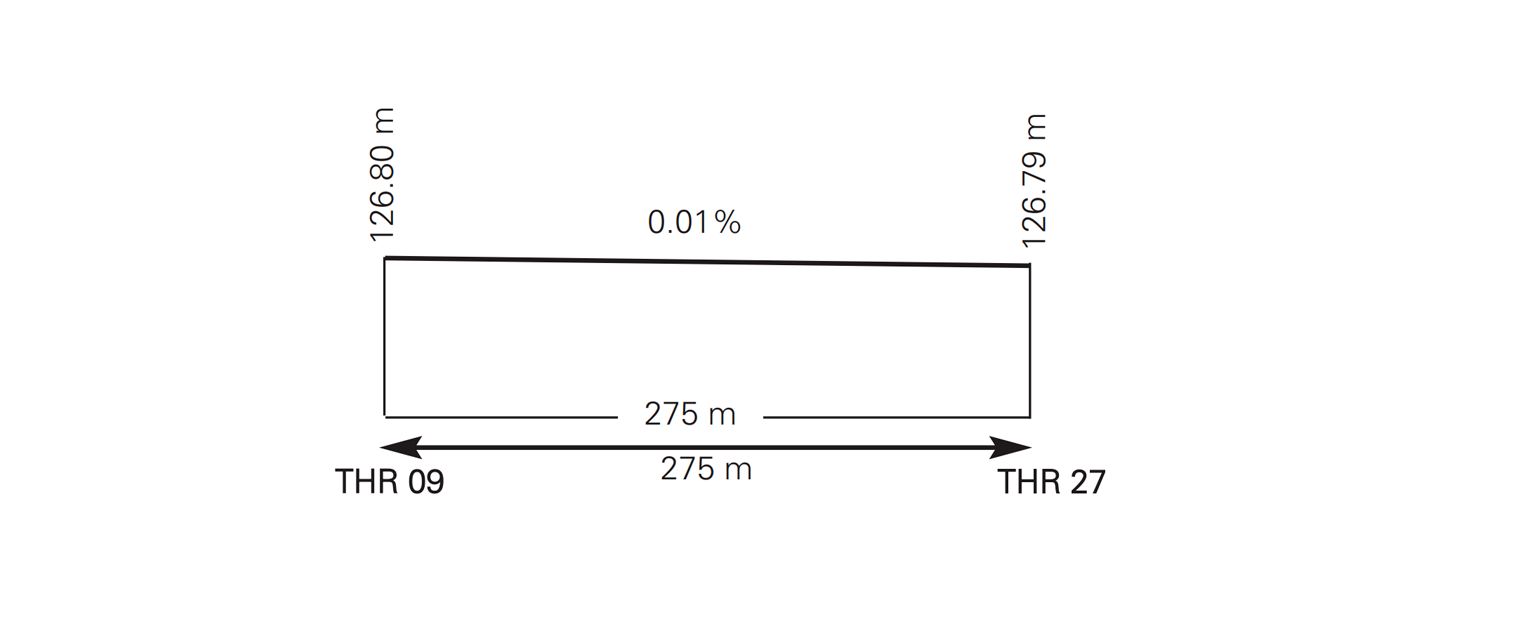
Magnetic heading: 091°–271°. THR 09: 393728.17N 0002827.20W. THR 27: 393727.94N 0002815.67W. THR 09: 127 m / 416 ft. THR 27: 127 m / 416 ft. |
|
Security zone dimensions |
INFO NO AVBL. |
|
Heliport CWY dimensions |
FATO 09: 30 x 30 m. FATO 27: 18 x 30 m. |
|
Clear sector |
INFO NO AVBL. |
|
Remarks |
None. |
Profile
DECLARED DISTANCES
FATO |
TODAH (m) |
RTODAH (m) |
LDAH (m) |
|---|---|---|---|
09 |
275 |
305 |
275 |
27 |
275 |
293 |
275 |
Remarks: None.
APPROACH AND FATO LIGHTING
FATO |
09 |
|
Approach |
No. |
|
APAPI |
No. |
FATO |
27 |
|
Approach |
No. |
|
APAPI |
No. |
|
FATO lighting |
Characteristics: Green/white/red/orange and red/green. |
|
Aiming point lighting |
No. |
|
TLOF lighting |
Characteristics: Orange with different intensities. |
|
|
Remarks |
(1) Variable lights intensity. |
OTHER LIGHTING, SECONDARY POWER SUPPLY
Heliport BCN |
No. |
|
WDI |
1 near ARP. |
|
TWY lighting |
Edge. |
|
Apron lighting |
Characteristics: Blue. |
|
Secondary power supply |
No. |
|
|
Remarks |
None. |
Air traffic services airspaceATS AIRSPACE
|
Designation |
ATZ BÉTERA.
|
Lateral limits |
Circle radius 5 km centred on HRP, limited to the south by CTR VALENCIA. (1) |
|
Vertical limits |
SFC - 1000 ft HGT (2). |
|
Airspace class |
D. |
|
|
Unit Language |
BÉTERA TWR. ES. |
Transition altitude |
1850 m / 6000 ft. |
|
Hours of applicability |
- |
|
Remarks |
(1) Or the ground visibility, whichever is lower. (2) Or up to the clouds ceiling, whichever is lower. |
Air traffic services communication facilitiesATS COMMUNICATION FACILITIES
Service |
Call sign |
FREQ |
HR |
Remarks |
|---|---|---|---|---|
APP |
Valencia APP |
120.100 MHz 124.750 MHz |
HR HLP HR HLP |
- |
TWR |
Bétera TWR |
126.750 MHz 129.375 MHz 121.500 MHz 243.000 MHz 339.200 MHz |
HR HLP HR HLP HR HLP HR HLP HR HLP |
EMERG EMERG |
RADIO NAVIGATION and landing aidsfacilities
Facility (VAR) |
ID |
FREQ |
HR |
Coordinates |
ELEV DME |
Remarks |
|---|---|---|---|---|---|---|
NDB (1ºE) |
EBT |
362KHz |
H24 |
393731.9N 0002819.4W |
- |
U/S BTN 339º-349º |
LOCAL heliportREGULATIONS
No.
NOISE ABATEMENT PROCEDURES
No.
FLIGHT PROCEDURES
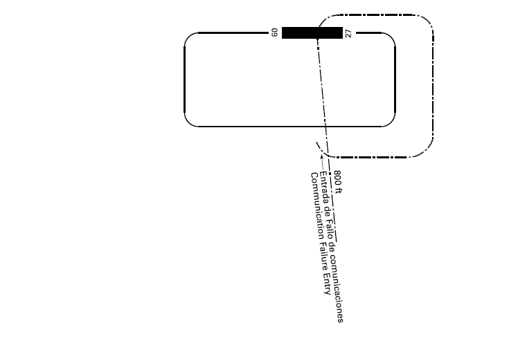
HLP TRAFFIC CIRCUIT
ADDITIONAL INFORMATION
No.
Charts related to a heliportCHARTS RELATED TO THE HELIPORT
The list of charts related to the heliport can be found on the link below:
VISUAL SEGMENT SURFACE (VSS) PENETRATION
Information not available.