LECV AD 3 HELIPORT DATA
HELIPORT LOCATION INDICATOR and-NAME
LECV - MADRID/Colmenar Viejo
HELIPORT GEOGRAPHICAL AND ADMINISTRATIVE DATA
Heliport reference point |
404150N 0034548W. See AD 3-LECV HELC. |
|
Distance and direction from the city |
3.5 km N. |
|
Elevation |
995 m / 3266 ft. |
|
Geoid undulation |
52.83 m ± 0.05 m. (1) |
|
Reference temperature |
30°C. |
|
Low average temperature |
5°C. |
|
Magnetic variation |
0° (2020). |
|
Annual change |
8.2’E. |
|
HLP administration |
Ejército de Tierra. |
|
Address |
Base Principal de las FAMET “Coronel Mate”. Ctra de Guadalix de la Sierra, km 3.8. 28770 - Colmenar Viejo (Madrid). |
|
TEL |
+34-918 463 393 |
|
FAX |
+34-918 465 328 |
|
AFTN |
LECV |
|
No. |
||
|
Approved traffic |
IFR/VFR. Exclusive military use. |
Remarks |
(1) For all HLP points. |
OPERATIONAL HOURS
Heliport |
MON-THU: V: 0545-1300; I: 0645-1400; |
|
Customs and Immigration |
No. |
|
Health and Sanitation |
No. |
|
AIS/ARO/OPV |
HR HLP. |
|
MET briefing |
SEP-JUN: V: 0600-1700; I: 0700-1800. |
|
ATS |
HR HLP. |
|
Fueling |
HJ. |
|
Handling |
HR HLP. |
|
Security |
H24. |
|
De-icing |
No. |
|
Remarks |
None. |
HANDLING SERVICES AND FACILITIES
Cargo facilities |
No. |
|
Fuel types |
JP-8. |
|
Oil types |
No. |
|
Refuelling capacity |
Trucks: 10000 L; 8.3 L/s. |
|
De-icing facilities |
No. |
|
Hangar space |
No. |
|
Repair facilities |
No. |
|
Remarks |
None. |
PASSENGER FACILITIES
Hotels |
No. |
|
Restaurant |
Yes. |
|
Transportation |
Yes. Available upon request from the principal UB. |
|
Medical facilities |
First aid and ambulance. |
|
Bank/Post Office |
No. |
|
Tourist information |
No. |
|
Remarks |
None. |
RESCUE AND FIREFIGHTINGSERVICES
Fire category |
H-3. |
|
Rescue equipment |
Yes. |
|
Removal of disabled helicopters |
Tractor with dragging bars. |
|
Remarks |
None. |
SEASONAL AVAILABILITY -/OBSTACLE CLEARING
Equipment |
Front loader vehicle and truck crane. |
|
Priority |
FATO and movement area. |
|
Remarks |
None. |
Aprons, taxiways and check locations/positions dataMOVEMENT AREA DETAILS
Apron |
Surface: Asphalt. Strength: CAT A. |
|
Stands |
Surface: Asphalt. Strength: CAT A. |
|
Taxiways |
Width: 20 m. Surface: Asphalt. Strength: CAT A. |
|
Check locations |
Altimeter: No. VOR: THR 21 340° 3.4 DME CNR. INS: No. |
|
Remarks |
None. |
MARKINGS AND MARKERS
Final approach markings |
Touch-down zone on both thresholds. Yellow circles. |
|
Take-off markings |
Touch-down zone on both thresholds. Yellow circles. |
|
TWY markings |
Centre line and taxi holding positions. |
|
Air TWY markers |
Yes. |
|
Air Transit Route markers |
No. |
|
Remarks |
None. |
HELIPORT OBSTACLES
In approach and take-off areas
Area |
Obstruction |
Coordinates |
|---|---|---|
03 |
High-voltage line 991 m / 3251 ft |
700 m / 244°MAG FM THR 03 |
21 |
Hill Hill Antenna Antenna |
3.0 km / 018°MAG 5.5 km / 051°MAG 404203.2N 0034540.3W
|
Remarks |
None. |
|
In circling area and at HLP
Obstruction |
Coordinates |
|---|---|
Tank |
404158.9N 0034551.8W |
Antenna |
404147.4N 0034602.6W |
Remarks |
None. |
METEOROLOGICAL INFORMATION SERVICE PROVIDED
MET office |
Colmenar Viejo OMD. |
|
HR |
MON-FRI: V: 0530-1800; I: 0630-1800. |
|
METAR |
Half-hourly. |
|
TAF |
24 HR. |
|
TREND |
No. |
|
Briefing |
In person and by telephone. |
|
Flight documentation/Language |
Charts and plain language / Spanish. |
|
Charts |
Significant, forecasted in altitude (wind and temperature) and maximum wind maps. |
|
Supplementary equipment |
No. |
|
ATS unit served |
OPV, TWR. |
|
Additional information |
Madrid OMAe (LEMC): H24; TEL: +34-915 045 807. TEL: +34-918 465 360; FAX: +34-918 465 360. |
|
Remarks |
Aerodrome warning available. |
HELIPORT DATA
Type of heliport |
Surface-level heliport. |
|
TLOF |
Dimensions: Two squares to 50x50 m. Coordinates Elevation |
|
FATO |
Magnetic heading: 035°-215°. THR 03: 404144.61N 0034552.86W. THR 03: 995 m / 3266 ft. |
|
FATO 2 |
Magnetic heading: 340°-160°. |
|
Security zone dimensions |
No. |
|
|
Heliport CWY dimensions |
No. |
|
Clear sector |
No. |
|
Remarks |
None. |
DECLARED DISTANCES
FATO |
TODAH (m) |
RTODAH (m) |
LDAH (m) |
|---|---|---|---|
03 |
524 |
524 |
524 |
21 |
524 |
524 |
524 |
FATO 2 |
50 |
50 |
50 |
Remarks: None.
APPROACH AND FATO LIGHTING
|
FATO |
03 |
|
Approach |
White. Distance between lights: 5 m. |
|
APAPI |
4.50°. |
|
FATO lighting |
Characteristics: White. Location: Edge, threshold and end. |
|
Aiming point lighting |
No. |
|
Remarks |
None. |
|
TLOF lighting |
Characteristics: Green. Location: Edge. Distance between lights: 5 m. Remarks: None. |
|
FATO |
21 |
|
Approach |
No. |
|
APAPI |
No. |
|
FATO lighting |
Characteristics: White. Location: Edge, threshold and end. |
|
Aiming point lighting |
No. |
|
Remarks |
None. |
|
TLOF lighting |
Characteristics: Green. Location: Edge. Distance between lights: 5 m. Remarks: None. |
|
FATO 2 |
(34/16) |
|
Approach |
White. Distance between lights: 5 m. |
|
APAPI |
3°. |
|
FATO lighting |
Characteristics: White. Location: Edge, threshold and end. |
|
Aiming point lighting |
No. |
|
Remarks |
None. |
|
TLOF lighting |
Characteristics: Green. Location: Edge. Distance between lights: 5 m. Remarks: None. |
OTHER LIGHTING, SECONDARY POWER SUPPLY
Heliport BCN |
No. |
|
WDI |
1 above the tank, 1 near THR 03. NO LGTD. |
|
TWY lighting |
Centre line. Green markers. |
|
Apron lighting |
Characteristics: Blue. Location: Perimeter. |
|
Secondary power supply |
Engine generator. |
|
|
Remarks |
None. |
Air traffic services airspaceATS AIRSPACE
|
Designation |
CTR COLMENAR VIEJO |
Lateral limits |
Circle of radius 4.2 NM centred at HRP, bounded to the South by the line joining the points: 403759N 003476W and 403942N 0034045W. |
|
Vertical limits |
SFC -1000 ft AGL |
|
Airspace class |
D |
|
|
Unit Language |
COLMENAR TWR ES/EN |
Transition altitude |
3962 m / 13000 ft |
|
Hours of applicability |
- |
|
Remarks: |
- |
|
Designation |
ATZ COLMENAR VIEJO |
Lateral limits |
Circle radius 8 km centred on HRP. (1) |
|
Vertical limits |
3000 ft HGT N of alignment (2) (3) |
|
Airspace class |
D |
|
|
Unit Language |
COLMENAR TWR ES/EN |
Transition altitude |
3962 m / 13000 ft |
|
Hours of applicability |
- |
|
Remarks: |
(1) Or the ground visibility, whichever is lower. |
Air traffic services communication facilitiesATS COMMUNICATION FACILITIES
Service |
Call sign |
FREQ |
HR |
Remarks |
|---|---|---|---|---|
APP |
Madrid APP |
118.400 MHz |
HR HLP |
APP/I |
TWR |
Colmenar TWR |
123.225 MHz |
HR HLP |
|
RADIO NAVIGATION and landing aidsfacilities
Facility (VAR) |
ID |
FREQ |
HR |
Coordinates |
ELEV |
Remarks |
|---|---|---|---|---|---|---|
NDB (0°) |
ECV |
319.000 kHz |
H24 |
404158.8N 0034546.1W |
- |
- |
LOCAL heliportREGULATIONS
OPERATIONAL MINIMA
The AD operational minima table for aircraft for landings and take-offs within the ATZ/CTR is as follows:
Cloud height (ft) |
Horizontal visibility (m) |
|
|---|---|---|
AD traffic circuit |
700 |
1800 |
DEP/ARR VFR |
1500 |
5000 |
DEP/ARR VFR ESPECIAL |
600 |
800 |
DEP/ARR OVFR |
500 |
800 |
APP IFR/OIFR |
Those marked on the approach chart |
|
DEP IFR/OIFR |
100 |
200 |
DEP/ARR AD traffic circuit AD |
1500 |
5000 |
DEP/ARR Night-time GVN |
500 |
4000 |
Aircraft on SAR missions or in emergency, at the discretion of their commanders. |
||
NOISE ABATEMENT PROCEDURES
No.
FLIGHT PROCEDURES
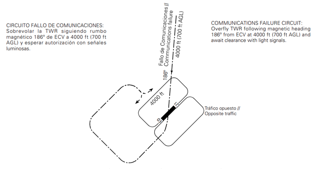
HLP TRAFFIC CIRCUIT
ADDITIONAL INFORMATION
No.
Charts related to a heliportCHARTS RELATED TO THE HELIPORT
The list of charts related to the heliport can be found on the link below:
VISUAL SEGMENT SURFACE (VSS) PENETRATION
No.