LELO AD 3 HELIPORT DATA
HELIPORT LOCATION INDICATOR and-NAME
LELO - LOGROÑO/Agoncillo
HELIPORT GEOGRAPHICAL AND ADMINISTRATIVE DATA
Heliport reference point | 422715N 0021915W. See AD 3-LELO HLP. | |
Distance and direction from the city | 10 km E. | |
Elevation | 352 m / 1155 ft. | |
Geoid undulation | 51 m ± 0.05 m (1). | |
Reference temperature | 30°C. | |
Low average temperature | 6°C. | |
Magnetic variation | 0° (2020). Annual change: 8.3'E. | |
HLP administration | Ejército de Tierra. | |
Address | Base de Agoncillo (Bhelma III). Ctra. de Zaragoza | |
Contact | TEL: +34-941 279 400 | |
AFTN | LELO | |
| Information not available. | |
Approved traffic | IFR/VFR. Exclusive military use. | |
Remarks | (1) For all HLP points. |
OPERATIONAL HOURS
Heliport | MON-THU: V: 0545-1300 / I: 0645-1400; | |
Customs and Immigration | No. | |
Health and Sanitation | No. | |
AIS/ARO/OPV | HR HLP. | |
MET briefing | HR HLP. | |
ATS | HR HLP. | |
Fueling | HR HLP. | |
Handling | HR HLP. | |
Security | H24. | |
De-icing | No. | |
Remarks | None. |
HANDLING SERVICES AND FACILITIES
Cargo facilities | Claws and ladders. | |
Fuel types | JP-8. | |
Oil types | No. | |
Refuelling capacity | Trucks: 5000 L; 7.5 L/s. | |
De-icing facilities | No. | |
Hangar space | No. | |
Repair facilities | No. | |
Remarks | None. |
PASSENGER FACILITIES
Hotels | Yes. | |
Restaurant | Yes. | |
Transportation | Limited. | |
Medical facilities | First aid and ambulance. | |
Bank/Post Office | No. | |
Tourist information | No. | |
Remarks | None. |
RESCUE AND FIREFIGHTINGSERVICES
Fire category | H-2. | |
Rescue equipment | No. | |
Removal of disabled helicopters | Tractor with dragging bars. | |
Remarks | None. |
SEASONAL AVAILABILITY -/OBSTACLE CLEARING
Equipment | Information not available. | |
Priority | RWY and movement area. | |
Remarks | None. |
Aprons, taxiways and check locations/positions dataMOVEMENT AREA DETAILS
Apron | Surface: Compacted natural soil. Strength: Information not available. | |
Taxiways | Width: 10 m. Surface: Asphalt. Strength: Information not available. | |
Check locations | Altimeter: No. VOR: No. INS: No. | |
Remarks | None. |
MARKINGS AND MARKERS
Taxiing guidance system | Information not available. | |
RWY markings | Designators. | |
TWY markings | Information not available. | |
Remarks | None. |
HELIPORT OBSTACLES
In approach and take-off areas
Area | Obstruction | Coordinates |
|---|---|---|
See AD 3-LELO HELC. | - | - |
Remarks | None. | |
In circling area and at AD
Obstruction | Coordinates |
|---|---|
Water tank | 42º27’05”N 002º20’13”W |
Electric tower | 42º27’21”N 002º20’25”W |
Remarks | None. |
METEOROLOGICAL INFORMATION SERVICE PROVIDED
MET office | Agoncillo OMD. | |
HR | HR HLP. Outside this schedule, a half-hourly METAR AUTO will be issued. | |
METAR | Half-hourly. | |
TAF | 24 HR. | |
TREND | No. | |
Briefing | In person and by telephone. | |
Flight documentation/Language | Charts and plain language / Spanish. | |
Charts | Significant, forecast wind and temperature at altitude. | |
Supplementary equipment | Cloud, lightning and radar information image display. | |
ATS unit served | TWR. | |
Additional information | Madrid OMAe (LEMC): H24; TEL: +34-915 045 807. FAX: +34-941 437 136. | |
Remarks | Aerodrome climatological summary available. Aerodrome warnings available. |
HELIPORT DATA
RWY | Direction | DIM (m) | THR PSN | THR ELEV / TDZ ELEV | SWY (m) | CWY (m) | Strip (m) | OFZ | RESA (m) | RWY/SWY SFC PCN |
|---|---|---|---|---|---|---|---|---|---|---|
10 | 097.65° GEO | 1452 x 60 | 422718.33N | THR: 352 m / 1155 ft | No | No | No | No | No | RWY: Natural soil (1) |
28 | 277.66° GEO | 1452 x 60 | 422712.06N | THR: 351 m / 1150 ft | No | No | No | No | No | RWY: Natural soil (1) |
Remarks: (1) Information not available.
DECLARED DISTANCES
RWY | TORA (m) | TODA (m) | ASDA (m) | LDA (m) |
|---|---|---|---|---|
10 | 1452 | 1452 | 1452 | 1452 |
28 | 1452 | 1452 | 1452 | 1452 |
Remarks: None.
Profile: Information not available.
APPROACH AND FATO LIGHTING
Runway | 10 | |
Approach | No. | |
VASIS/PAPI | No. | |
Threshold | No. | |
Touch-down zone | No. | |
Runway centre line | No. | |
Runway edge | No. | |
Runway end | No. | |
Stopway | No. | |
Remarks | None. |
Runway | 28 | |
Approach | No. | |
VASIS/PAPI | No. | |
Threshold | No. | |
| Touch-down zone | No. |
| Runway centre line | No. |
| Runway edge | No. |
| Runway end | No. |
| Stopway | No. |
| Remarks | None. |
OTHER LIGHTING, SECONDARY POWER SUPPLY
ABN/IBN | No. | |
WDI/LDI | 1 near HRP. LGT. | |
TWY lighting | No. | |
Apron lighting | 1 floodlighting tower. | |
Secondary power supply | No. | |
| Remarks | None. |
Air traffic services airspaceATS AIRSPACE
| Designation | CTR LOGROÑO |
Lateral limits | 423339N 0023308W; 423339N 0023055W; 423053N | |
Vertical limits | SFC - 1000 ft AGL | |
Airspace class | D | |
| Unit Language | Logroño TWR (ES/EN) |
Transition altitude | 1850 m / 6000 ft | |
Hours of applicability | - | |
Remarks | - |
| Designation | ATZ LOGROÑO |
Lateral limits | Circle radius 8 km centred on DVOR/DME LPA. (1). | |
Vertical limits | SFC - 3000 ft HGT (2) | |
Airspace class | D | |
| Unit Language | Logroño TWR (ES/EN) |
Transition altitude | - | |
Hours of applicability | - | |
Remarks | (1) Or the ground visibility, whichever is lower. |
Air traffic services communication facilitiesATS COMMUNICATION FACILITIES
Service | Call sign | FREQ | HR | Remarks |
|---|---|---|---|---|
TWR | Logroño TWR | 123.225 | HR HLP |
|
RADIO NAVIGATION and landing aidsfacilities
Installation (VAR) | ID | FREQ | HR | Coordinates | ELEV DME | Remarks |
|---|---|---|---|---|---|---|
DVOR (0°) | LPA | 115.450 MHz | H24 | 422737.9N 0021936.9W | - | COV at 40 NM NO AVBL BTN: |
DME | LPA | CH 101Y | H24 | 422737.5N 0021937.1W | 360 m | COV at 40 NM NO AVBL BTN: |
NDB (0°) | EAG | 399 kHz | HR HLP | 422705.0N 0021852.9W | - | COV 45 NM |
LOCAL heliportREGULATIONS
Flight plans with origin and/or destination from/to Logroño AD shall be addressed to both location indicators LERJZTZX (Logroño AD control tower) and LELOZTZX (Agoncillo Airbase control tower).
NOISE ABATEMENT PROCEDURES
No.
FLIGHT PROCEDURES
HLP TRAFFIC CIRCUIT
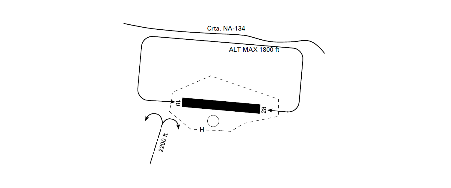
COMMUNICATIONS FAILURE
Stay to the south of the airfield with TWR in sight, without crossing the motorway, to enter the communications failure circuit (2200 ft MAX).
ADDITIONAL INFORMATION
No.
Charts related to a heliportCHARTS RELATED TO THE HELIPORT
The list of charts related to the heliport can be found on the link below:
VISUAL SEGMENT SURFACE (VSS) PENETRATION
Not applicable.