LEda AD 2 AERODROME DATA
AERODROME LOCATION INDICATOR AND NAME
LEDA - LLEIDA/Alguaire
AERODROME GEOGRAPHICAL AND ADMINISTRATIVE DATA
ARP | 414341N 0003207E. See AD 2-LEDA ADC. | |
Distance and direction from the city | 16 km NW. | |
Elevation | 351 m / 1152 ft. | |
Geoid undulation | 50 m ± 0.05 m (1). | |
Reference temperature | 32°C. | |
Low average temperature | 4ºC. | |
Magnetic variation | 2ºE (2025). | |
Annual change | 9.1'E. | |
AD administration | Aeroports de Catalunya. | |
Address | Aeropuerto de Lleida / Alguaire - 25125, Alguaire (Lleida). | |
TEL | +34-973 032 700 | |
FAX | +34-973 032 768 | |
AFTN | LEDA | |
Approved traffic | IFR/VFR. (2) | |
Remarks | SITA: ILDAPXH (1) For all AD points. (2) During the periods of time in which the aerodrome is not controlled, only VFR or night VFR flights are permitted. See item 20. Local Regulations. |
OPERATIONAL HOURS
Airport (1) | V: 0600-1800 I: 0700-1700 (2) (3). | |
Customs and Immigration | HR AD 48 HR PPR. | |
Health and Sanitation | No. | |
AIS/ARO | HR AD. | |
MET briefing | HR ATS. | |
ATS | V: 0600-1800 I: 0700-1700 O/T: PPR 48HR before the operation. | |
Fuelling | Variable depending on needs. Consult CECOA (cecoa@leda.cat). O/T: PPR 48 HR before refuelling to:
| |
Handling | HR ATS. Other HR PPR 48 HR to:
| |
Security | H24. | |
De-icing | No. | |
Remarks | (1) In the event that the ATS schedule is extended, the airport's schedule will be extended accordingly to completely cover it. (2) Possible temporary closures during airport operational hours which will be communicated via NOTAM. (3) Apron management service (SDP): provided by CECOA. |
HANDLING SERVICES AND FACILITIES
Cargo facilities | No. | |
Fuel types | JET A-1, AVGAS 100LL. | |
Oil types | No | |
Refuelling capacity | JET A-1: 2 tankers 35000 L, 15 L/s. AVGAS 100LL: 1 tanker 8000 L, 3.3 L/s. | |
De-Icing facilities | No. | |
Hangar space | No. | |
Repair facilities | Yes. Maintenance Service Area AERONPARK
Maintenance apron Sector 1
| |
Remarks | None. |
PASSENGER FACILITIES
Hotels | No. | |
Restaurant | Yes. | |
Transportation | Taxi. | |
Medical facilities | First aid kit. | |
Bank/Post Office | No / No. | |
Tourist information | Yes. | |
Remarks | None. |
RESCUE AND FIREFIGHTING SERVICES
Fire category | HR AD: CAT 7: FRI, SUN. CAT 4: MON, TUE, WED, THU, SAT. Other categories, PPR 48H before the operation notifying to CECOA. (1) | |
Rescue equipment | According to the fire category published. | |
Removal of disabled aircraft | Service provided by external companies in the area, response time between 30 and 60 minutes. Load capacity up to 300T. (2) | |
Remarks | (1) CAT 8: Scheduled flights: PPR 15 days before the expected day of operation notifying to CECOA. Non-scheduled flights: PPR 3 days before the expected day of operation notifying to CECOA.
(2) Responsible for coordinating the aircraft transfer operation: Head of Operations. Contact through the Airport Operations office:
|
RUNWAY SURFACE CONDITION ASSESSMENT AND REPORTING, AND SNOW PLAN
Types of clearing equipment | Not applicable. | |
Clearance priorities | Not applicable. | |
Use of material for movement area surface treatment | Not applicable. | |
Specially prepared winter runways | Not applicable. | |
Remarks | Runway surface condition assessment and reporting in accordance with the Global Reporting Format (GRF) methodology described in AD 1.2.2. Aerodrome in service during all seasons of the year. |
APRONS, TAXIWAYS AND CHECK LOCATIONS/POSITIONS DATA
Apron | Surface: Concrete. Strength: PCN 50/R/C/W/T. | |
Taxiways | Width: TWY A: 23 m. Surface: TWY A: Asphalt. Strength: TWY A: PCN 51/F/A/W/T. | |
Check locations | Altimeter: Apron: ELEV: 349 m / 1144 ft. VOR: No. INS: See AD 2-LEDA PDC. | |
Remarks | None. |
SURFACE MOVEMENT GUIDANCE AND CONTROL SYSTEM AND MARKINGS
Taxiing guidance system | Runway-holding position (A1), directional signs to stands, boards, stands and NO ENTRY markings. | |
RWY markings | Designators, threshold, displaced threshold RWY 31, centre line, side stripe, aiming point, touchdown zone and pre-threshold area. | |
TWY markings | Enhanced center line and side strip. | |
Remarks | None. |
AERODROME OBSTACLES
In approach/take-off, circling and AD areas
DESIGNATION | DESCRIPTION | COORDINATES | ELEV / HGT (M) | MARKED |
|---|---|---|---|---|
LLD-OBS13-0204-2008 | Antenna | 414412.4N 0003122.3E | 350 / 3 | Yes |
LLD-OBS31-0321-2008 | Fence | 414253.2N 0003316.2E | 370 / 2 | No |
LLD-OBS31-0322-2008 | Fence | 414254.0N 0003316.4E | 369 / 2 | No |
LLD-MEGA-0192-2008 | Mega tower | 414348.5N 0003226.6E | 381 / 32 | Yes |
LLD-MEGA-0195-2008 | Mega tower | 414346.7N 0003229.2E | 381 / 32 | Yes |
LLD-MEGA-0196-2008 | Mega tower | 414344.9N 0003231.7E | 381 / 32 | Yes |
LLD-MEGA-0197-2008 | Mega tower | 414343.0N 0003234.4E | 381 / 32 | Yes |
LLD-OBS-0218-2008 | Building | 414343.8N 0003233.6E | 356 / - | No |
LLD-OBS-0219-2008 | TWR | 414341.8N 0003236.7E | 392 / - | No |
LLD-OBS-0220-2008 | Building | 414340.3N 0003238.6E | 356 / - | No |
LLD-WDI-0406-2009 | Wind indicator | 414406.8N 0003135.1E | 357 / 8 | Yes |
LLD-WDI-0414-2009 | Wind indicator | 414314.4N 0003239.8E | 357 / 8 | Yes |
LLD-OBS-0562-2009 | Antenna | 414340.4N 0003238.6E | 360 / - | No |
LLD-OBS-0563-2009 | Antenna | 414340.9N 0003236.9E | 359 / 10 | No |
LLD-OBS-0566-2009 | Antenna | 414343.7N 0003233.9E | 360 / - | No |
LLD-OBS-0567-2009 | Antenna | 414341.8N 0003236.8E | 394 / - | No |
Remarks: See AD 2-LEDA AOC.
METEOROLOGICAL INFORMATION PROVIDED
MET office | Lleida EMAe. | |
HR | HR ATS. Outside these hours, a half-hourly METAR AUTO will be issued. | |
METAR | Half-hourly. | |
TAF | 24 HR. | |
TREND | No. | |
Briefing | In person and by telephone. | |
Flight documentation/Language | Charts and plain language / Spanish. | |
Charts | Significant, forecasted in altitude (wind and temperature) maps. | |
Supplementary equipment | Clouds and lightnings image and radar information display. | |
ATS unit served | TWR. | |
Additional information | Valencia OMAe (LEVA): H24
Lleida EMAe: HR AD
| |
Remarks | Aerodrome warnings available. During not on the spot hours the following service will be provided:
|
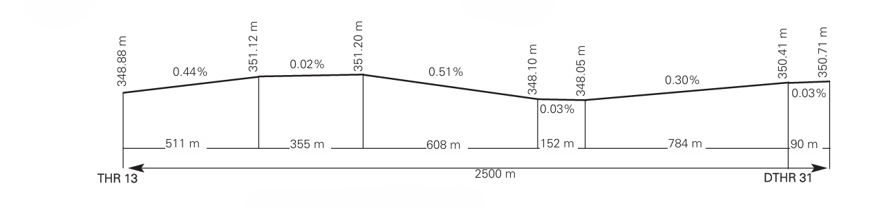
RUNWAY PHYSICAL CHARACTERISTICS
RWY | Direction | DIM (m) | THR PSN | THR ELEV | SWY (m) | CWY (m) | Strip (m) | OFZ | RESA (m) | RWY/SWY SFC PCN |
|---|---|---|---|---|---|---|---|---|---|---|
13 (1) | 133.33º GEO 132º MAG | 2500 x 61 | 414408.37N 0003128.13E | THR: 349 m/1145 ft TDZ: No | No | No | 2620 x 300 | No | 240 x 150 | RWY: ASPH PCN 51/F/A/W/T. SWY: No |
31 (2) | 313.35º GEO 312º MAG | 2500 x 61 | 414314.76N 0003243.96E | THR: 350.4 m/1150 ft TDZ: 350.4 m/1150 ft | No | No | 2620 x 300 | No | 240 x 150 | RWY: ASPH PCN 51/F/A/W/T. SWY: No |
Remarks: (1) End RWY 13 coordinates: 414312.71N 0003246.91E. (2) THR RWY 31 displaced 90 m. | ||||||||||
Profile
DECLARED DISTANCES
RWY | TORA (m) | TODA (m) | ASDA (m) | LDA (m) |
|---|---|---|---|---|
13 | 2500 | 2500 | 2500 | 2500 |
31 | 2500 | 2500 | 2500 | 2410 |
31 INT A | 1512 | 1512 | 1512 | – |
Remarks: None. | ||||
APPROACH AND RUNWAY LIGHTING
Runway | 13 | |
Approach | Simple, 420 m. | |
PAPI (MEHT) | 3º (16.37 m / 54 ft). | |
Threshold | Green. | |
Touchdown zone | No. | |
Runway centre line | 2500 m: 1600 m white + 600 m white and red + 300 m red. Distance between lights: 30 m. (1) | |
Runway edge | 2500 m = 1900 m white + 600 m yellow. Distance between lights: 50 m. (1) | |
Runway end | Red. | |
Stopway | No. | |
Remarks | Halogen lights. (1) Adjustable intensity lights. |
Runway | 31 | |
Approach | Precision CAT I, 900 m. Threshold identification lights. (1) | |
PAPI (MEHT) | 3º (16.97 m / 56 ft). | |
Threshold | Green. | |
Touchdown zone | No. | |
Runway centre line | 2410 m: 1510 m white + 600 m white and red + 300 m red. Distance between lights: 30 m. (1) | |
Runway edge | 2410 m = 1810 m white + 600 m yellow. Distance between lights: 50 m. (1) | |
Runway end | Red. | |
Stopway | No. | |
Remarks | Halogen lights. (1) Adjustable intensity lights. |
OTHER LIGHTING, SECONDARY POWER SUPPLY
ABN/IBN | No. | |
WDI | 1 near THR 13, 1 near THR 31. LGTD. | |
TWY lighting | Edge. (1) | |
Apron lighting | 4 poles with 6 floodlighting. LIH. (1) | |
Secondary power supply | Engine generators that provide a maximum switch-over (light) time of 15 s for emergency services / Uninterrupted Power Supply (UPS) with switch-over (light) time of 0 s for approach lights, PAPI, threshold, centre line, edge, runway end and protection lights. | |
Remarks | (1) LED technology lighting system. |
HELICOPTER LANDING AREA
Position | Geoid undulation, see item 2.
| |
Elevation |
| |
Dimensions, surface, maximum weight, marking |
| |
Taxiways | See items 8 and 9. | |
Direction | FATO: RWY 13/31. See item 12. | |
Declared distances | FATO: RWY 13/31. See item 13. | |
Lighting |
Taxiways: See items 8 and 9. | |
Remarks | None. |
AIR TRAFFIC SERVICES AIRSPACE
Designation and lateral limits | CTR LLEIDA. Circle radius 6 NM centred on ARP. (1) | |
Vertical limits | SFC-3000 ft ALT.
| |
Airspace class | D. | |
Unit | LLEIDA TWR (2). | |
Language | ES/EN. | |
Transition altitude | 1850 m / 6000 ft. | |
| Hours of applicability | -HR ATS. |
| Remarks | (1) During the periods of time in which the aerodrome is not controlled, the CTR disappears. (2) Call sign: Lleida TWR. HR ATS: see item 3. |
Designation and lateral limits | ATZ LLEIDA (RMZ) (3). Circle radius 8 km centred on ARP. (4)(3). | |
Vertical limits | SFC-MAX ALT VFR SECTOR.
| |
Airspace class | G. | |
Language | ES/EN. | |
Hours of applicability | -ATZ is only available outside of ATS hours. | |
| Remarks | (3) ATZ is only available outside of ATS hours. (4)(3) Or the ground visibility, whichever is lower. |
AIR TRAFFIC SERVICES COMMUNICATION FACILITIES
Service | Call sign | FREQ | HR | Remarks |
|---|---|---|---|---|
APP | Barcelona Control | 127.700 MHz | HR ATS | APP/H |
TWR | Lleida TWR (1) | 121.330 C (2) | HR ATS | - |
121.500 MHz | HR ATS | EMERG | ||
121.630 C | HR ATS | GMC (1) TWR operation in limited hours. See item 3. (2) Out of TWR operation hours, this frequency will be used for communications between pilots considering NO ATS as frequency. See item 20. Local regulations. | ||
RADIO NAVIGATION AND LANDING AIDS
Facility (VAR) | ID | FREQ | HR | Coordinates | ELEV DME | Remarks |
|---|---|---|---|---|---|---|
DVOR (2º E) | LLE | 113.600 MHz | H24 | 414347.2N 0003138.6E | - | - |
DME | LLE | CH 83X | H24 | 414347.2N 0003138.6E | 360 m | - |
NDB (2º E) | LRD | 404.000 KHz | H24 | 413310.5N 0003852.9E | - | COV 50 NM |
LOC 31 ILS CAT I (2º E) | ILL | 110.900 MHz | H24 | 414414.5N 0003119.5E | - | 132º MAG / 275 m FM THR 13. COV 25 NM |
GP 31 | 330.800 MHz | H24 | 414319.5N 0003230.8E | - | 3º; RDH 15.9 m; at 338 m FM THR 31 & 103 m FM RCL on the left in APCH direction. COV 25 NM | |
ILS/DME 31 | ILL | CH 46X | H24 | 414319.5N 0003230.8E | 354 m | REF DME THR 31 |
LOCAL AERODROME REGULATIONS
Airport with Aerodrome Control Service during limited hours (see item 3). During the periods of time in which the airport is not controlled:
VFR/IFR approach and take-off/take-off practice flights, shall be authorised on a restricted basis according to the air traffic situation.
Only VFR flights are permitted. Night VFR flights are permitted subject to PPR 48 HR, to the following e-mail address: cecoa@leda.cat.
VFR flights will monitor the TWR frequency 121.330 C (NO ATS frequency during this time) and will transmit their intentions thereon, as well as the evolution of different phases of their flight, for knowledge and where appropriate, separation by other aircraft that are part of the aerodrome traffic.
None of the airport's aeronautical stations will respond or confirm receipt of these communications.
Departing VFR flights will comply with the VFR procedures in TMA Barcelona published in the ENR 6.5-11. When leaving the ATZ they will monitor on frequency 127.700 MHz and will not call unless necessary.
Departing VFR flights intending to continue their IFR flight will formulate a "Z" flight plan and request ATC clearance from BARCELONA ACC on frequency 127.700 MHz before take-off. Arriving IFR flights will formulate a "Y" flight plan and will be approved by BARCELONA ACC until DVOR LLE at a 4000 ft. altitude, where they will cancel IFR and continue on VFR.
The control tower in its frequency will spread a message announcing the beginning and end of the provision of the Control Service.
Airport with reduced meteorological service (see item 3). During not on the spot hours the service provided will be that specified in the Remarks section of item 11.
TURNING ON RUNWAY
A 180º turn on RWY is permitted from sunrise to sunset and outside low visibility conditions (LVP).
Aircraft requesting to make this turn shall notify TWR when landing on RWY 31. Maximum permitted aircraft DA42.
GROUND MOVEMENT
Outside ATS hours, pilots must contact CECOA for the assignment of parking stands on 121.630 MHz.
All ground movements of aircraft, towed aircraft, persons and vehicles in the manoeuvring area are subject to prior ATC clearance. Aircraft guidance from the apron transfer point to the parking stand is provided if so requested by the pilot or TWR.
All movements of aircraft, towed aircraft, persons and vehicles on the apron shall be regulated by the Apron Safety Regulations.
Avoidance of collisions with other aircraft or obstacles is the responsibility of:
Pilots, when taxiing on the apron.
Ground handling companies during parking stand exit manoeuvres with push-back, and during towing.
TWR clearances and instructions must be read back.
TAXIING RESTRICTIONS ON APRON
Aircraft classification according to chapter 1 of Annex 14 ICAO:
Code letter D: wingspan equal or greater than 36 m, and less than 52 m.
Code letter C: wingspan equal or greater than 24 m, and less than 36 m.
Code letter B or below: wingspan less than 24 m.
Access to the apron is limited to a maximum code letter D aircraft (B753), taking into account their parking restrictions.
Limitation on apron taxiing for circulation of code letter C aircraft going to Sector 1 with PRKG 1A occupied.
Weight limitation on apron:
B738: 74000 kg.
A21N: 75000 kg.
OPERATIONAL SAFETY REPORTS
In the specific instance of safety reports related with the air traffic control service provider (manoeuvring area, flight phases and ATS airspace) these may be sent to the e-mail address:
TAKE-OFFS FROM INTERSECTION
Take-off operations are permitted from the intersection of RWY 31 with TWY A (see distances in item 13).
Aircraft must request this from ATC at the moment of start-up.
An informational board is provided at the intersection stating the distance available for take-off.
Take-offs from the intersection will only be permitted between sunrise and sunset and in the absence of LVC.
NOISE ABATEMENT PROCEDURES
No.
FLIGHT PROCEDURES
Threshold RWY 31 is preferred for take-offs of code letter C or higher aircraft.
RESTRICTIONS TO HELICOPTERS
Helicopter air taxiing is allowed.
Landing will be accomplished on the RWY in use. Air taxiing will take place from the RWY to the stand on TWY A.
Helicopters will park on the apron in the parking position indicated by the ATS unit.
STANDSTILL OF OPERATIONS IN THE MOVEMENT AREA PROCEDURE (PPOAM)
A "Standstill of Operations in the Movement Area Procedure for RVR lower than 550 m" (PPOAM 550) is available, which consists of the following phases:
CONDITIONS FOR THE ACTIVATION OF EACH OF THE PHASES OF THE PPOAM | ||
|---|---|---|
PHASES | RVR | VISIBILITY |
PHASE I (WARNING) | ≤ 800 m | ≤ 1200 m |
PHASE II (STANDSTILL OF OPERATIONS) | < 550 m | < 800 m |
PHASE III (RESUMPTION OF OPERATIONS) | ≥ 550 m, and there is a firm improving trend | ≥ 800 m, and there is a firm improving trend |
INFORMATION FOR PILOTS
Uncertainty about position in the manoeuvring area
When in doubt about the position of the aircraft with respect to the manoeuvring area:
If it is recognised that the aircraft is not on a runway, the aircraft will be immediately stopped and ATC will be notified of this circumstance (including the last known position).
If it is recognised that the aircraft is on a runway, ATC will be notified immediately (including the last known position) and the runway will be vacated, as soon as possible, provided it is possible to locate an appropriate taxiway close to its position, unless ATC indicates otherwise; and, following this, the aircraft will stop.
Failure of an aircraft
Notify ATC of the situation and wait for the arrival of assistance. In the case that the aircraft is on a runway, if possible and unless ATC indicates otherwise, the pilot will vacate the runway.
Loss of visual contact between traffic
In the case of loss of visual contact with another aircraft or a vehicle with which own separation is being maintained, ATC will be informed immediately and the aircraft will stop.
Communications failure
Departing aircraft: the aircraft shall continue by the designated route and stop at the limit of the ATC clearance, taking extreme caution. Here it will hold and wait for the arrival of an assistance vehicle.
Arriving aircraft: if the aircraft has just landed, it shall hold in the first segment of the taxiway which leaves the ILS sensitive area free and wait for the arrival of an assistance vehicle.
If the aircraft already has ATC taxiing clearance, it shall continue by the designated route and stop at the limit of that clearance, taking extreme caution. Here it will hold and wait for the arrival of an assistance vehicle.
ATS SURVEILLANCE SYSTEM
The air traffic controllers at the aerodrome shall maintain a constant visual surveillance over all the operations at the AD or its vicinity. An ATS surveillance system is available in support of such visual observation above 2300 ft AMSL, for the monitoring of flight paths of aircraft operating within LEDA CTR, as stipulated in article 4.5.1.3 of the Reglamento de la Circulación Aérea.
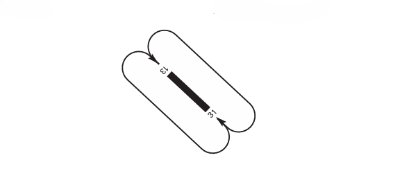
AD TRAFFIC CIRCUIT
ADDITIONAL INFORMATION
The airport of Lleida/Alguaire has the appropriate means and local procedures to handle aircraft with code letter D, up to maximum B753. The turning speed for aircraft with code letter D on turn pads is limited to 21 Km/h.
For operations of code letter E aircraft without cargo or passengers, contact the airport manager at cecoa@aeroportlleida.cat.
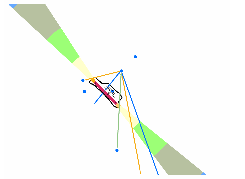
BIRD CONCENTRATION AREAS AND FLOW
Presence of storks and gulls in the following areas.
AERONAUTICAL CHARTS RELATED TO AN AERODROME
The list of charts related to the aerodrome can be found on the link below:
VISUAL SEGMENT SURFACE (VSS) PENETRATION
The instrument approach procedures affected can be found below:
IAC 1 RNP Z RWY 13 (LPV ONLY): LPV.
IAC 2 RNP Y RWY 13: LNAV/VNAV.
IAC 3 VOR RWY 13: direct approach.
IAC 6 ILS RWY 31: direct approach.
IAC 7 LOC RWY 31: direct approach.
IAC 8 VOR RWY 31: direct approach.