LEGT AD 2 AERODROME DATA
AERODROME LOCATION INDICATORAND NAME
LEGT - MADRID/Getafe
AERODROME GEOGRAPHICAL AND ADMINISTRATIVE DATA
ARP |
401739N 0034325W. See AD 2-LEGT ADC. |
|
Distance and direction from the city |
15 km SW. |
|
Elevation |
619 m / 2032 ft. |
|
Geoid undulation |
51 m ± 0.05 m (1). |
|
Reference temperature |
33°C. |
|
Low average temperature |
6ºC. |
|
Magnetic variation |
1º E (2025). |
|
Annual change |
9.5' E. |
|
AD administration |
Ejército del Aire y del Espacio. |
|
Address |
Base Aérea de Getafe, Avd. John Lennon, s/n. 28071 Getafe (Madrid). |
|
TEL / FAX |
+34-917 798 200 / +34-917 798 610 |
|
AFTN |
LEGT |
|
Approved traffic |
IFR/VFR. MIL: Exceptionally used by civil aircraft with express prior clearance from the military ATC authority. |
|
Remarks |
(1) For all AD points. |
OPERATIONAL HOURS
Airport |
V: 0530-1900; I: 0630-2000; Other hours according to needs of Unit (1). |
|
Customs and Immigration |
No. |
|
Health and Sanitation |
No. |
|
AIS/ARO/OPV |
HR AD. |
|
MET briefing |
0600-1800. Other hours according to needs of Unit. MAX 2300. |
|
ATS |
HR AD. |
|
Fuelling |
MIL: HR AD. |
|
Handling |
HR AD. |
|
Security |
H24. |
|
De-icing |
No. |
|
Remarks |
(1) Foreign State aircraft: see item 20. |
HANDLING SERVICES AND FACILITIES
Cargo facilities |
Forklift truck up to 8 TM and pallet transfer system up to 13.5 TM. |
|
Fuel types |
F-34. |
|
Oil types |
O-113, O-117, O-123, O-125, O-142, O-147, O-148, O-153, O-156, O-157, O-158, O-190, O-216, O-226, O-228, O-237, O-283, O-1177, O-1178, O-1236. |
|
Refuelling capacity |
Trucks: 20000 L; 16.66 L/s. |
|
De-Icing facilities |
No. |
|
Hangar space |
No. |
|
Repair facilities |
No. |
|
Remarks |
MIL: GPU: Unit of AC (up to 100 KVA) and DC (up to 2500 A). |
PASSENGER FACILITIES
Hotels |
MIL: Yes. |
|
Restaurant |
MIL: Yes. |
|
Transportation |
CIV: Buses and taxis. MIL: Buses and light vehicles available on request. |
|
Medical facilities |
First aid and ambulance. |
|
Bank/Post Office |
Cash dispenser / No. |
|
Tourist information |
No. |
|
Remarks |
None. |
RESCUE AND FIREFIGHTING SERVICES
Fire category |
5 (1). |
|
Rescue equipment |
MIL: In accordance with the fire category published. |
|
Removal of disabled aircraft |
No (2). |
|
Remarks |
(1) Upgradeable to CAT 7 upon PPR request at least 48 HR in advance. Upgradeable to CAT 8 only for Airbus DS cleared aircraft, upon PPR request at least 48 HR in advance. (2) Availability in MAESMA MADRID of crane up to 10000 Kg, at the request of the CITAM. |
RUNWAY SURFACE CONDITION ASSESSMENT AND REPORTING, AND SNOW PLAN
Equipment |
No. |
|
Priority |
No. |
|
Remarks |
None. |
APRONS, TAXIWAYS AND CHECK LOCATIONS/POSITIONS DATA
Apron |
Surface: Concrete. Strength: P1 PCN 39/R/C/W/T EXC first 260 m from Eastern limit: PCN 57/R/C/W/T. P2 PCN 66/R/C/W/T EXC first 200 m from Southern limit: PCN 41/R/C/W/T. P3 PCN 49/R/C/W/T. |
|
Taxiways |
Width: 25 m, except CA5: 23 m + 3.5 m flexible pavement edge. Surface: Asphalt. Strength: TA: PCN 87/F/C/W/T, CA1: PCN 63/F/C/W/T, CA2: PCN 78/F/C/W/T, CA3: PCN 33/R/B/W/T, CA4: PCN 121/F/C/W/T, CA5: PCN 65/R/C/X/U. |
|
Check locations |
Altimeter: THR 04: 619 m / 2032 ft. THR 22: 611 m / 2004 ft. VOR: No. INS: No. |
|
Remarks |
None. |
SURFACE MOVEMENT GUIDANCE AND CONTROL SYSTEM AND MARKINGS
Taxiing guidance system |
NO ENTRY boards, runway-holding position. |
|
RWY markings |
Designators, threshold, centre line, side stripe, touchdown zone and fixed distance. |
|
TWY markings |
Centre line. |
|
Remarks |
None. |
AERODROME OBSTACLES
In approach and take-off areas |
In circling area and at AD |
|||
|---|---|---|---|---|
RWY Area |
Obstruction |
Coordinates |
Obstruction |
Coordinates |
22 APCH / 04 TKOF |
Building 645 m/2116 ft |
401751N 0034244W |
Antenna 664 m/2179 ft |
401821N 0034325W |
Hill 670 m/2198 ft LGTD |
401835N 0034103W |
Chimenea 629 m/2064 ft |
401756N 0034205W |
|
Antenna 627 m/2057 ft LGTD |
401825N 0034311W |
|||
04 APCH / 22 TKOF |
Meseta 683 m/2241 ft |
401450N 0034501W |
||
Chimney 649 m/2129 ft |
401614N 0034517W |
|||
Building 659 m/2162 ft |
401437N 0034706W |
|||
Remarks: See AD 2-LEGT AOC.
METEOROLOGICAL INFORMATION PROVIDED
MET office |
CIV: Madrid/Getafe OMD. MIL: Getafe OMD. |
|
HR |
0600-1800. Other hours according to needs of Unit. Max 2300. |
|
METAR |
Half-hourly. |
|
TAF |
24 HR. |
|
TREND |
No. |
|
Briefing |
In person and by telephone. |
|
Flight documentation / Language |
Charts and plain language/Spanish. |
|
Charts |
Significant forecast and wind and temperature in altitude maps. |
|
Supplementary equipment |
Cloud image display. |
|
ATS unit served |
TWR, OPV. |
|
Additional information |
Madrid OMAe (LEMC): H24
MADRID/Getafe MET office
|
|
Remarks |
Aerodrome climatological summary available. Aerodrome warnings available. |
RUNWAY PHYSICAL CHARACTERISTICS
RWY |
Direction |
Dimensions (m) |
THR PSN |
THR ELEV/TDZ |
SWY (m) |
CWY (m) |
Strip (m) |
OFZ |
RESA (m) |
RWY/SWY SFC PCN |
|---|---|---|---|---|---|---|---|---|---|---|
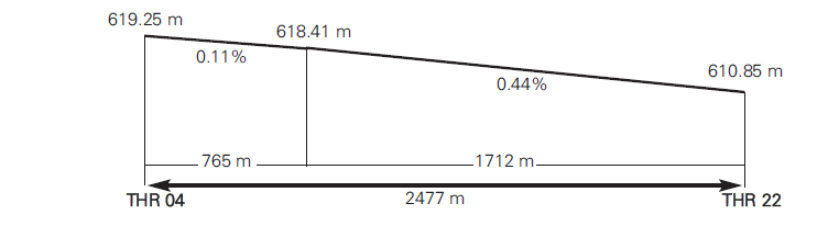
04 |
045.19° GEO / 045° MAG |
2477 x 60 |
401710.34N 0034402.64W |
THR: 619.3 m / 2032 ft |
150 x 60 |
150 x 60 |
2490 x 74 |
No |
No |
RWY: ASPH PCN 70 R/B/W/T (1); PCN 71 R/C/W/T (2); PCN 73 R/C/W/T (3); PCN 93 R/B/W/T (4); PCN 66 R/B/W/T (5) SWY: INFO NO AVBL |
22 |
225.20° GEO / 225° MAG |
2477 x 60 |
401806.93N 0034248.23W |
THR: 611 m / 2004 ft |
125 x 60 |
375 x 60 |
2490 x 74 |
No |
No |
RWY: ASPH PCN 70 R/B/W/T (1); PCN 71 R/C/W/T (2); PCN 73 R/C/W/T (3); PCN 93 R/B/W/T (4); PCN 66 R/B/W/T (5) SWY: INFO NO AVBL |
Remarks |
(1) RWY 04: 0 m - 500 m; RWY 22: 2040 m - 2477 m. (2) RWY 04: 500 m - 1060 m; RWY 22: 1480 m - 2040 m. (3) RWY 04: 1060 m - 1700 m; RWY 22: 840 m - 1480 m. (4) RWY 04: 1700 m - 2160 m; RWY 22: 380 m - 840 m. (5) RWY 04: 2160 m - 2477 m; RWY 22: 0 m - 380 m. |
|||||||||
PROFILE
DECLARED DISTANCES
RWY |
TORA (m) |
TODA (m) |
ASDA (m) |
LDA (m) |
|---|---|---|---|---|
04 |
2477 |
2627 |
2627 |
2477 |
22 |
2477 |
2852 |
2602 |
2477 |
04 INT CA3 |
1567 |
1717 |
1717 |
– |
22 INT CA2 |
1770 |
2145 |
1895 |
– |
Remarks |
None. |
|||
APPROACH AND RUNWAY LIGHTING
Runway |
04 |
|
Approach |
Precision CAT I 540 m. (1) |
|
PAPI (MEHT) |
3° (20.59 m / 68 ft). |
|
Threshold |
Green. |
|
Touchdown zone |
No. |
|
Runway centre line |
NoYes. |
|
Runway edge |
2477 m white. (1) |
|
Runway end |
Red. |
|
Stopway |
No. |
|
Remarks |
(1) Adjustable light intensity. |
Runway |
22 |
|
Approach |
Simple, 420 m. (1) |
|
PAPI (MEHT) |
3° (19.70 m / 65 ft). |
|
Threshold |
Green. |
|
Touchdown zone |
No. |
|
Runway centre line |
NoYes. |
|
Runway edge |
2477 m white. (1) |
|
Runway end |
Red. |
|
Stopway |
No. |
|
Remarks |
(1) Adjustable light intensity. |
OTHER LIGHTING, SECONDARY POWER SUPPLY
ABN/IBN |
No. |
|
WDI |
1 near TWR, 1 near THR 04. Not LGTD. |
|
TWY lighting |
Edge, EXC: CA5. |
|
Apron lighting |
No. |
|
Secondary power supply |
Engine generator that provides a switch-over time of 20 seconds. |
|
Remarks |
None. |
HELICOPTER ALIGHTING AREA
Position |
To SE of TWR (Private EADS - C.A.S.A factory). |
|
Elevation |
No. |
|
Dimensions, surface, maximum weight, marking |
No. |
|
Direction |
No. |
|
Declared distances |
No. |
|
Lighting |
No. |
|
Remarks |
None. |
AIR TRAFFIC SERVICES AIRSPACE
Designation |
CTR MADRID. |
|
Lateral limits |
403301.53N 0034658.39W; arc centred on DVOR/DME BRA (402808.9N 0033327.1W), radius 11.4 NM; 402158.81N 0032053.71W; 401544.73N 0031457.24W; 400611.28N 0032929.16W; 401222.89N 0033746.85W; 400809.08N 0034614.61W; 401320.10N 0035258.35W; 401642.37N 0034856.17W; arc centred on MADRID/Getafe AD (401738.6N 0034325.4W), radius 8.0 km; 402038.71N 0034729.48W; arc centred on MADRID/Cuatro Vientos AD (402214.4N 0034706.5W), radius 3.0 km; 402146.76N 0034504.54W; arc centred on MADRID/Getafe AD (401738.6N 0034325.4W), radius 8.0 km; 402154.86N 0034232.04W; 402308.24N 0034112.60W; 403301.53N 0034658.39W. |
|
Vertical limits |
SFC-1000 ft AGL. |
|
Airspace class |
D (1). |
|
Unit Language |
MADRID APP. ES/EN. |
|
Transition altitude |
3962 m / 13000 ft. |
|
Hours of applicability |
- |
|
Remarks |
(1) Visual flights only allowed to Spanish military aircraft from/to Ministerio de Defensa facilities. |
Designation |
ATZ MADRID/GETAFE |
|
Lateral limits |
Circle radius 8 km centred on ARP (2). |
|
Vertical limits |
SFC-3000 ft AGL (3). |
|
Airspace class |
D. |
|
Unit Language |
GETAFE TWR. ES/EN. |
|
Transition altitude |
- |
|
Hours of applicability |
- |
|
Remarks |
(2) Or the ground visibility, whichever is lower. (3) Or up to the cloud ceiling, whichever is lower. |
AIR TRAFFIC SERVICES COMMUNICATION FACILITIES
Service |
Call sign |
FREQ |
HR |
Remarks |
|---|---|---|---|---|
APP |
Madrid APP |
127.100 MHz |
H24 |
INITIAL |
119.950 MHz |
HR AD |
MIL |
||
124.230 |
C H24 |
DEP W |
||
TWR |
Getafe TWR |
121.500 MHz |
HR AD |
EMERG |
121.605 |
C HR AD |
GMC |
||
129.930 |
C HR AD |
LOCAL MIL |
||
139.305 |
C HR AD |
MIL |
||
243.000 MHz |
HR AD |
EMERG |
||
257.800 MHz |
HR AD |
MIL |
||
342.650 MHz |
HR AD |
LOCAL MIL |
RADIO NAVIGATION AND LANDING AIDS
Facility (VAR) |
ID |
FREQ |
HR |
Coordinates |
ELEV/DME |
Remarks |
|---|---|---|---|---|---|---|
DVOR/TACAN (1ºE) |
VGE |
112.050 MHz CH 57Y |
H24 |
401723.4N 0034334.2W |
630 m |
- |
NDB (0ºE) |
GE |
421.000 kHz |
H24 |
401159.2N 0035039.4W |
- |
COV 30 NM
|
LOC 04 (1ºE) ILS CAT I |
IGE |
110.900 MHz |
H24 |
401812.7N 0034240.7W |
- |
045ºMAG / 252 m FM THR 22. |
GP 04 |
330.800 MHz |
H24 |
401715.1N 0034349.1W |
- |
3°; RDH 15 m; at 120 m FM RCL to the right in the direction of APCH. |
|
ILS/DME 04 |
IGE |
CH 46X |
H24 |
401715.1N 0034349.1W |
617 m |
REF DME THR 04. |
LOCAL AERODROME REGULATIONS
Foreign state aircraft
For foreign state aircraft, a PPR request is mandatory 48 hours in advance. When transporting dangerous goods, it will be requested at least 72 hours in advance. As a general rule, PPR will not be accepted within the following hours:
-
V: FRI 1200 to MON 0530.
-
I: FRI 1330 to MON 0630.
NOISE ABATEMENT PROCEDURES
No.
FLIGHT PROCEDURES
Adjustment of vertical speed in Madrid TMA
Aircraft in evolution shall adjust their vertical speed when approaching the assigned altitude or flight level. In these circumstances, the vertical speed shall be reduced to 1500 ft per minute when approaching a vertical distance of 1000 ft above or below the assigned altitude or flight level.
AD traffic circuit
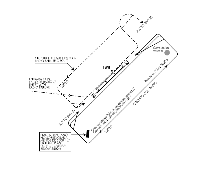
Radio failure circuit
Aircraft with radio failure shall enter this circuit by the NW quadrant at an angle of 45° with reference to RWY 04/22. To check the RWY in use, pilots shall overfly the TWR in parallel to RWY 04/22, always keeping to the left of the TWY and between the TWY and TWR.
Helicopters circuit
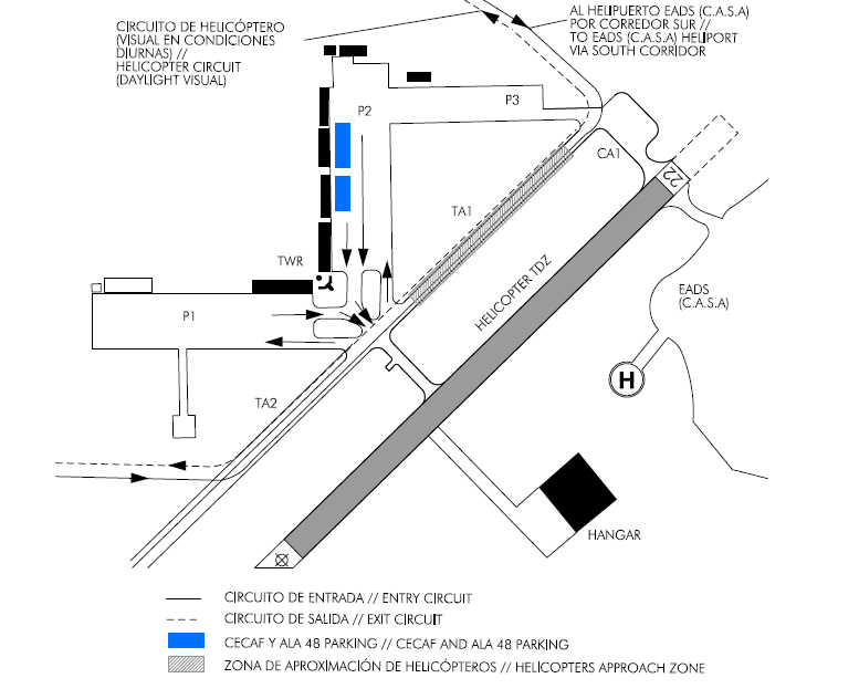
Circuit characteristics:
1. Helicopters will remain between 100 ft and 200 ft AGL in the helicopter circuit.
2. Access to the helicopter circuit is through the NORTH CORRIDOR.
3. Flyover from SOUTH CORRIDOR to NORTH CORRIDOR or vice versa, will be conducted through the circuit cleared for all types of aircraft.
4. In case of special circumstances due to winds or helicopter loads, or any other reasons, pilots will accomplish the most suitable manoeuvre (with prior aerodrome control clearance), avoiding to fly at a low altitude, over parked or taxiing aircraft.
5. Aerodrome control may provide clearance for crossing the departure RWY, or any other place within the aerodrome area, when traffic allows.
6. Helicopters will head for the segment T.A.1 where contact will be established. Next they will taxi to the parking stand following TWR instructions.
7. Arrivals and departures to/from E.A.D.S. (C.A.S.A.) heliport, proceed by south corridor at 2500 ft.
ADDITIONAL INFORMATION
Arresting systems
Nomenclature: LEGT-01-C-B.
Type: RETRACTABLE BIDIRECTIONAL CABLE BARRIER.
Location on: RWY 04 THR+565 m/1857 ft. RWY 22 THR+1911 m/6270 ft.
Readiness status: Permanently available at the pilot request.
Nomenclature: LEGT-02-C-B.
Type: RETRACTABLE BIDIRECTIONAL CABLE BARRIER.
Location on: RWY 04 THR+1946 m/6385 ft. RWY 22 THR+530 m/1742 ft.
Readiness status: Permanently available at the pilot request.
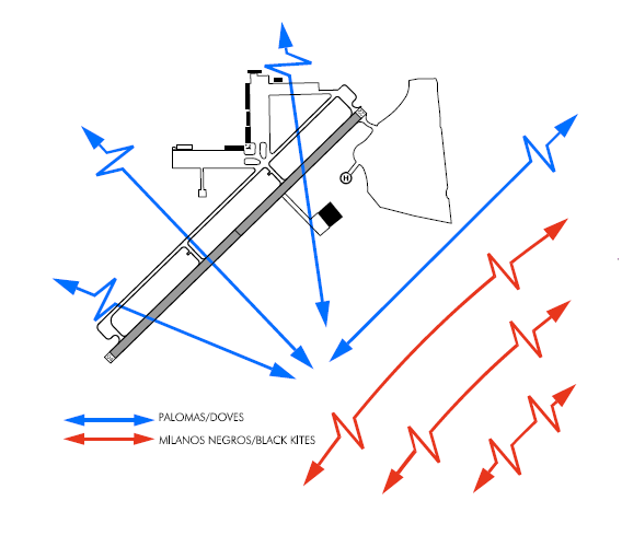
Bird concentration
Caution is recommended due to bird concentration over RWY 04/22.
MOVEMENT OF BIRDS
AERONAUTICAL CHARTS RELATED TO AN AERODROME
The list of charts related to the aerodrome can be found on the link below:
VISUAL SEGMENT SURFACE (VSS) PENETRATION
Not applicable.